| Previous :: Next Topic |
| Author |
Message |
scott&lucy
Member

Joined: 13 Mar 2007
Posts: 24 | TRs | Pics
|
I had the day off so you get good photos and an essay trip report!
Well we were supposed to do a loop backpack from Sloan Creek CG up the North Fork Sauk to the PCT, along to Kodak Peak, then back along Pilot Ridge, however my buddy Mr A felt too weak as we ascended towards White Pass, so we re-planned things on the fly...
We left Seattle around 3pm on Friday after a mishap involving a GPS & a car roof... Got to the TH around 6pm & started up the trail. We checked the crossing over the N Fork Sauk to the Johnson Ridge trail: I say there's no problem at all--plenty of big easy logs to cross, Mr A's not quite so sure of my judgment, but agrees he may be able to make it across, somehow. Sorry, no picture taken.
We continue up the trail which is nice up & down through old growth till roughly Red Creek. There the old growth seems to disappear & the forest becomes creepy dark, thick second growth. The big news is that there is an awesome trail crew camped out at Red Creek for the next week who are brushing out the trail, and constructing a new portion that must be almost a ½ mile long around a washed out area between Red Creek & the Mackinaw Shelter. The Red Creek crossing isn't bad for me (some nice logs just upstream of the trail), Mr A isn't so sure but makes it across...eventually =)
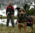
 Nice Old Trees  Sloan Peak through the maples  Red Creek Bridge  morning flowers 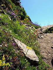 more morning flowers 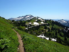 The PCT looking towards White Pass with Indian Head & Kodak Peaks  Glacier Lilies at White Pass  Marmot watching Lucy  Lucy watching Marmot  Pasque Flowers below Red Pass  Glacier Peak from Portal Peak  Red Pass Camp  Resting Dog 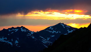 Rainshowers & sun over Sloan  Looking to the south at sunset 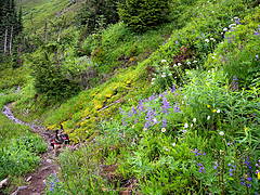 Wet Lucy in the flowers  Green waterfall  Flowers in the drizzle  Sloan above the mist  Scott & Lucy back across Red Creek | Code: | | 5500' gain
20.5 mi
2 days
Trails mud & snow free
Some bugs but not annoying |
|
| Back to top |
  
|
|
Magellan
Brutally Handsome

Joined: 26 Jul 2006
Posts: 13116 | TRs | Pics
Location: Inexorable descent |
|
Magellan
Brutally Handsome
|
 Mon Jul 13, 2009 7:32 pm |
|
|
Totally sweet! 
|
| Back to top |
|
|
ericrjensen
Member

Joined: 12 Oct 2008
Posts: 58 | TRs | Pics
|
Wow this looks INCREDIBLE!  I am not pressed to respond to trip reports often but these pictures are outstanding, and I haven't even read the content yet! I am not pressed to respond to trip reports often but these pictures are outstanding, and I haven't even read the content yet!  Nice job and thanks for posting on an unfamiliar area (at least to me)
|
| Back to top |
|
|
Alpine Balding
Member

Joined: 09 Feb 2008
Posts: 59 | TRs | Pics
Location: Snohomish,Wa |
Very nice .I plan on backpacking that loop Labor day weekend ,with a side trip to Red pass and mabye cinder cone if time and energy permits
P.S. Those giant trees are amazing
|
| Back to top |
|
|
Justus S.
Member

Joined: 17 Nov 2004
Posts: 1298 | TRs | Pics
Location: WA |
Up there by white & red passes is just beautiful. Thanks for sharing
|
| Back to top |
|
|
David¹
Token Canadian

Joined: 25 Jul 2002
Posts: 3040 | TRs | Pics
Location: The Great White North |
|
David¹
Token Canadian
|
Mon Jul 13, 2009 8:45 pm |
|
|
How apropos.
Surprising lack of snow up there.
Thanks for the report.
|
| Back to top |
|
|
Flora
Enjoying the Sun!

Joined: 25 Mar 2007
Posts: 1035 | TRs | Pics
Location: Land of many waters |
|
Flora
Enjoying the Sun!
|
Mon Jul 13, 2009 9:20 pm |
|
|
Beautiful area. Brings back a few old memories. Thanks.
|
| Back to top |
|
|
puzzlr
Mid Fork Rocks

Joined: 13 Feb 2007
Posts: 7220 | TRs | Pics
Location: Stuck in the middle |
|
puzzlr
Mid Fork Rocks
|
Mon Jul 13, 2009 9:36 pm |
|
|
| scott&lucy wrote: | Red Pass Camp |
Great campsite and photo
|
| Back to top |
|
|
Foist
Sultan of Sweat

Joined: 08 May 2006
Posts: 3974 | TRs | Pics
Location: Back! |
|
Foist
Sultan of Sweat
|
Tue Jul 14, 2009 10:11 am |
|
|
Gorgeous.
I was planning on going to that area at the very beginning of September. I'm also surprised by how little snow is up there already. Do you think there will still be water at the White Pass campsites by then? I know it's hard to tell these things...
|
| Back to top |
|
|
Kim Brown
Member
Joined: 13 Jul 2009
Posts: 6900 | TRs | Pics
|
Foist
Ive been there in mid-September before, and found water tumbling across the PCT right before White Pass (if youre coming from N Fk Sauk). Load up before descending to the campsites. (I've never been able to find the water source down there - I've heard about it, but have always had the place to myself with no one to show me)
It's the only campground that's completely void of rocks. Think about that when you're there. There aren't any rocks laying around. It's wierd. So if you need rocks, get those from the PCT, too.
"..living on the east side of the Sierra world be ideal - except for harsher winters and the chance of apocalyptic fires burning the whole area."
Bosterson, NWHiker's marketing expert
"..living on the east side of the Sierra world be ideal - except for harsher winters and the chance of apocalyptic fires burning the whole area."
Bosterson, NWHiker's marketing expert
|
| Back to top |
|
|
scott&lucy
Member
Joined: 13 Mar 2007
Posts: 24 | TRs | Pics
|
Thanks for the compliments. It's almost hard to not take good pictures with the awesome weather that we had, but it was also nice to be able to sit & chill for hours (and snap photos) rather than putting the miles on. If only I had 5 day weekends!
@Foist: There was a lot less snow than I thought there would be--I should have left my ice axe at home... But then if you think about it all the slopes we were on were south facing so it makes sense. There's still a lot of snow in the White Chuck & White River valleys so I think you'll find some water at White Pass, even if you have to descend into the valley a little bit to get it. I was mainly worried about snow on the high route to Blue Lake, and around Dishpan Gap--I don't know if I've ever seen Dishpan Gap without snow, but I guess I'm usually in that area fairly early in the season.
@Balding: You should be able to do that over Labor Day weekend no problem if you do what we did & get as far as Mackinaw on Friday evening. That'll let you set up camp at White Pass on Saturday (or just hide your packs somewhere at the PCT Junction) and get out to Cinder Cone as a day trip, and then still give you Sunday & Monday to get to Blue Lake & Pilot Ridge. The PCT is so easy to hike on--even though that portion that hasn't been maintained to PCT standards in a few years. If you go to Cinder Cone I'd recommend trying to go back cross country via Portal; the views are outstanding.
|
| Back to top |
|
|
Go Jo
of the lykkens

Joined: 08 Jun 2003
Posts: 2248 | TRs | Pics
Location: Around The Bend |
|
Go Jo
of the lykkens
|
Tue Jul 14, 2009 6:59 pm |
|
|
| scott&lucy wrote: | Rainshowers & sun over Sloan |
I love it when weather collides for an interesting shot. Great TR ~Jo
|
| Back to top |
|
|
Pepper
Member

Joined: 10 Apr 2009
Posts: 80 | TRs | Pics
Location: Ballard |
|
Pepper
Member
|
Mon Jul 20, 2009 7:48 pm |
|
|
thanks for the TR and photos I will be up that way this weekend.
|
| Back to top |
|
|
bonobo
Owl Juggler for rent
Joined: 23 Jun 2004
Posts: 818 | TRs | Pics
|
|
bonobo
Owl Juggler for rent
|
Tue Jul 21, 2009 7:36 pm |
|
|
I think with the hot weather we're having, our hike this weekend is going to be to Red Creek. Sounds like a nice stretch of trail to spend a hot day on. Is the road the road is repaired all the way to the trailhead? FS website says so, but you know how that goes....
Thanks for a great TR! I can't wait to hit this one.
|
| Back to top |
|
|
Vertical Smile
Member
Joined: 21 Jul 2009
Posts: 27 | TRs | Pics
Location: Great Northwest |
SWEET trip. Looks like you have a good hiking partner there. (dog)
I want to do that loop this summer.
Re-duce,
Re-use and
Recycle
Re-duce,
Re-use and
Recycle
|
| Back to top |
|
|
|
|


