| Previous :: Next Topic |
| Author |
Message |
seattlehikertoo
Member


Joined: 26 Jun 2008
Posts: 582 | TRs | Pics
Location: Finding an alternative to Mailbox Pk |
With all the construction I've done around my house, you'd think that ladders wouldn't bother me a bit; they don't unless there are 2000 vertical feet of mountain air awaiting one fateful step. I've been trying to overcome my mild acrophobia and general aversion to exposure. So, when Stefan K (not to be confused with the Stefan poster here) invited me to Three Fingers, I couldn't resist putting him through the agony of convincing me to ascend the infamous third ladder to the lookout.
I had read reports on getting to the lookout and knew the third ladder may be an issue for me, but adding the fact that we didn't get on the trail until late afternoon, meant we would be going up that ladder in darkness - well Stefan did, anyway. I waited until dawn as there was a great camping spot just 150 feet below the lookout. I cannot thank him enough for coaxing me up that ladder in the early morning light. It did wonders for my confidence in exposed situations. The views more than lived up to their expectations despite the fog and haze from a new burn in the neighboring Mt Bullon area.
Some important notes about the route:
1) It is at least 8 miles NOT 7 one way. My GPS said 8.25, but we had some tricky snow and moat to cross (see number 2).
2) There are no snow issues until you get to Tin Can Gap. Then, the trail disappears at a crossing on 40+ degree snow for about 50 feet, but you can stay higher on the snow or drop down depending on comfort level. The second crossing you come to is at the top of a moat where there is a yellow rope tied to a tree to help you down. I do not recommend this way. The moat steepens sharply below the end of the rope, and there was no safe way to straddle the rock and the snow. We chose to angle down the snow field toward the basin and traverse back below the moat, and then up a minor scramble where we were able to pick up the trail briefly before a third crossing that is in the 45 degree range.
3) After these snow crossings, the trail is fairly easy to pick up, but you need to pay attention. At around 6200 feet, there is another snowfield to ascend. It was no problem. The snow has long consolidated. At the top of this, there is a saddle with the obvious way up to the right shown in this picture:
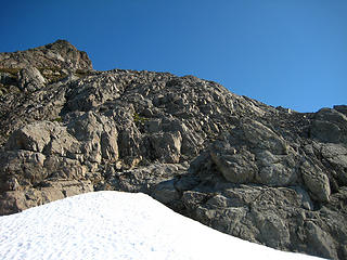 Crest of the 2nd to last snowfield pointing the way up 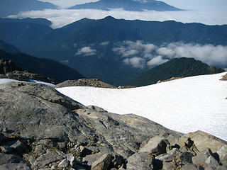 Looking down snowfield below the summit block 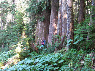 Stefan checking out the big cedars near the beginning of the trail 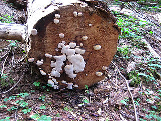 Log fungus 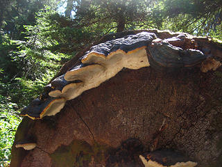 Fungus and worms near Saddle Lake 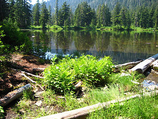 Saddle Lake 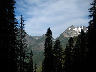 First glimpse of 3 Fingers on the right 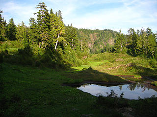 Meadow below just below Goat Flats 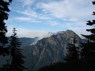 New forest fire evident in the Mt Bullon area 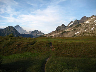 Goat Flats with the burn on the left and 3 Fingers on the right  Entering Goat Flats  Lower portion of Goat Flats with the shoulder of our destination above 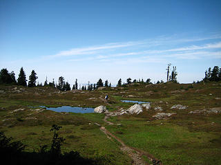 Goat Flat tarns 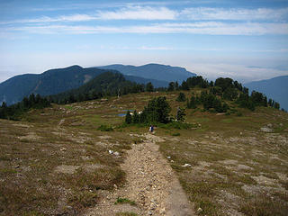 Heading back down to Goat Flats 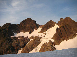 Looking over the receded cornice at 3 Fingers near Tin Can Gap. 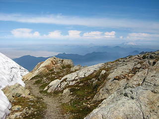 Interesting clouds with Mt Baker near a sketchy snow crossing beyond Tin Can Gap 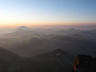 Early morning light and haze 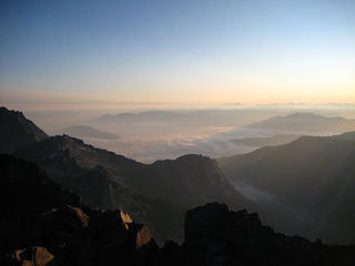 Fog everywhere below, but warm and cozy up here 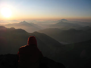 Sun glancing off Stefan's head as he stares at Pugh and Glacier Pk 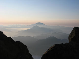 Mt Pugh in front of Glacier Peak 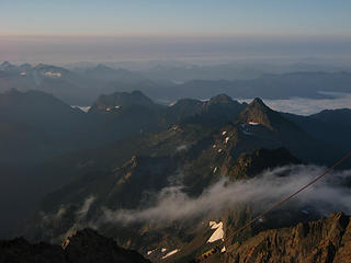 Streaming fog 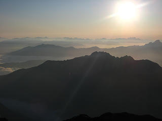 Sun over the fog 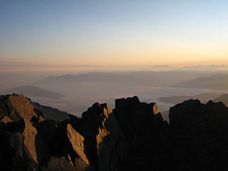 socked in valleys 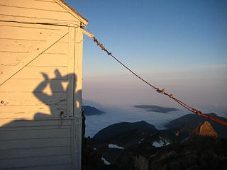 Early morning puppet show 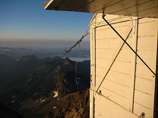 Lookout SE 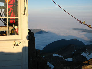 3 Finger shadow across a blanket of fog 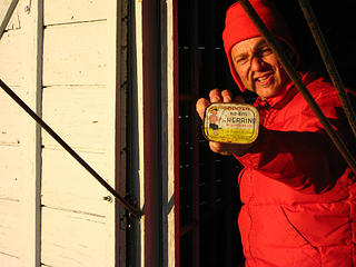 Stefan's ideal breakfast 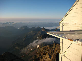 Lookout with fog bending over the ridge below 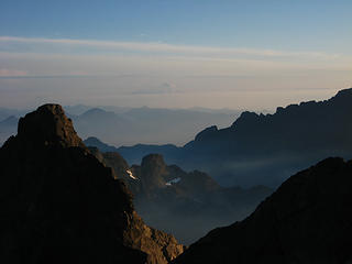 Baker in the distance with the North finger to the left 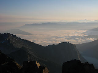 Morning fog for the city dwellers, warn sun up here socked in valleys 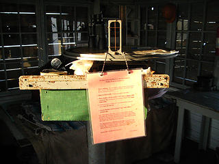 Lookout rules 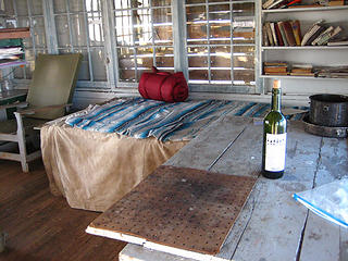 Lookout 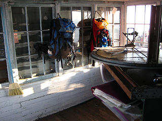 Lookout map 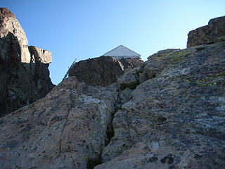 Very scary third ladder to the lookout 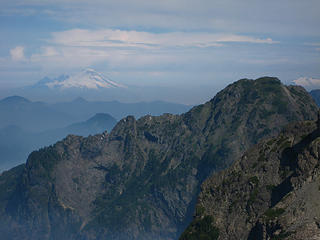 Baker touching the clouds 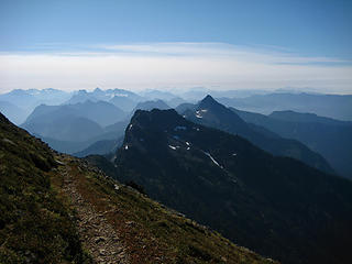 Mountain haze from just below Tin Can Gap 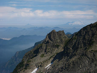 Baker from above Tin Can Gap
|
| Back to top |
  
|
|
Go Jo
of the lykkens

Joined: 08 Jun 2003
Posts: 2248 | TRs | Pics
Location: Around The Bend |
|
Go Jo
of the lykkens
|
 Sat Aug 08, 2009 12:37 am |
|
|
| seattlehikertoo wrote: | Early morning puppet show |
Good to hear you crossed a fear barrier, onward & upward for you! Great TR ~Jo
|
| Back to top |
|
|
Obi Tony Kenobi
Waterfall Crazy!

Joined: 25 Jun 2007
Posts: 1899 | TRs | Pics
Location: Marysville, WA |
Congrats on overcoming that fear, I hope I can do it too next week.
I am a little concern, are those snow fields before or after Tin Can Gap? I wasn't sure when I read your report and I don't have an ice ax so I don't want to deal with this. I'm going to guess I only have to deal with this after the ladders or if I'm going to the lookout?
Thanks and great pictures!
|
| Back to top |
|
|
seattlehikertoo
Member
Joined: 26 Jun 2008
Posts: 582 | TRs | Pics
Location: Finding an alternative to Mailbox Pk |
Snowfields are after Tin Can Gap. You need an ice axe. Do not attempt it without it, or if you do not know how to use one. The snow is before the ladders. The ladders are at the very end.
|
| Back to top |
|
|
Obi Tony Kenobi
Waterfall Crazy!
Joined: 25 Jun 2007
Posts: 1899 | TRs | Pics
Location: Marysville, WA |
Thank you Seattlehikertoo! I now have an excuse not to climb the ladders!  If they are as freaky as people say they are I can deal with them later once I know how to use an ice ax. Can't wait to go up and spend the night at Tin Can Gap! If they are as freaky as people say they are I can deal with them later once I know how to use an ice ax. Can't wait to go up and spend the night at Tin Can Gap!
|
| Back to top |
|
|
tmatlack
Member

Joined: 21 Aug 2007
Posts: 2854 | TRs | Pics
|
|
tmatlack
Member
|
Sat Aug 08, 2009 3:22 am |
|
|
Obes, et al,
I don't remember much level ground at Tin Can Gap for tenting or even bivouac.
I have irrational vertigo/fear of heights/exposure too and made it up the ladders. I crawled on the middle (?)rock platform, but no one seemed to mind.
On my 1st try the step from Tin Can Gap to snowfield was just too much for possible consequences of a slide down to the rocks. I turned around there. On the 2nd trip the snow was much softer, step smaller, ice axe, and no problems at all.
PS: One heck of a dayhike haul for average hiker, IMHO.
Tom
|
| Back to top |
|
|
jeremybe
Ol' One-shirt

Joined: 17 Jul 2008
Posts: 275 | TRs | Pics
Location: Seattle |
|
jeremybe
Ol' One-shirt
|
Sat Aug 08, 2009 6:47 am |
|
|
Congrats on conquering that fear. I've got some serious issues in that respect that I need to take care of as well. I better do a few simple scrambles...
Thanks for the report! 
|
| Back to top |
|
|
naturealbeing
Member

Joined: 05 Dec 2004
Posts: 1565 | TRs | Pics
Location: Great Mystery |
seattlehikertoo,
That's great! that you pushed through your comfort zone to get past those ladders and get the rewards of being present at the lookout.
Thanks for taking the time to share your TR, pics, & current conditions of Three Fingers.
Your experience reminds me of my first time up there (Sept. 1996), I went with my cousin and a friend of his. I got to Tin Can Gap ahead of them, there were some clouds coming in from the S, and there was a steady wind blowing. I had to make a choice to layer up and wait for them or keep my body temp up and continue on. After waiting about 15 minutes I choose to keep going. Some books claim that the lookout is another 1/2 mile away, but I think most would agree that it's quite a bit further.
Anyways, once I got to the ladders all I could think about, was the effort it took to this point and not getting to the LO became a non option. By concentrating on each and every step and hand hold and not thinking about anything else was the key for me.
Thinking my partners would be showing up soon I opened up the lookout and made myself at home. As it turned out those clouds moved in and I was cloaked from my partners held up at TCG for about an hour. During the wait I was hoping that the clouds were just passing through, as I wasn't to excited on making my way back down under those conditions. Once the clouds parted I could see them down at TCG and it appeared that they had bailed on proceeding, so I buttoned everything up and headed down.
|
| Back to top |
|
|
11th Essential
Member
Joined: 09 Jun 2007
Posts: 203 | TRs | Pics
Location: Shoreline, WA |
Thanks for posting your TR and all the pics. Glad to hear you made it to the top after all the effort to get to the ladders. Good to know the road has been fixed to gain access to the trailhead.
Even though you just passed through Goat Flats and didn't camp, any sense of how bad the skeeters were in that area? It's so boggy am thinking it the bugs would be swarming....
|
| Back to top |
|
|
Backpacker Joe
Blind Hiker

Joined: 16 Dec 2001
Posts: 23956 | TRs | Pics
Location: Cle Elum |
"If destruction be our lot we must ourselves be its author and finisher. As a nation of freemen we must live through all time or die by suicide."
Abraham Lincoln
|
| Back to top |
|
|
Sore Feet
Member

Joined: 16 Dec 2001
Posts: 6307 | TRs | Pics
Location: Out There, Somewhere |
Any flowers of note showing up there?
|
| Back to top |
|
|
seattlehikertoo
Member
Joined: 26 Jun 2008
Posts: 582 | TRs | Pics
Location: Finding an alternative to Mailbox Pk |
road is in good shape. still some big holes here and there. no wildflowers to note. my guess is it is past peak, except places near where the snow is still receding.
|
| Back to top |
|
|
4HzGp8
Member

Joined: 08 Aug 2009
Posts: 1 | TRs | Pics
|
|
4HzGp8
Member
|
Sat Aug 08, 2009 5:22 pm |
|
|
I hiked up and back yesterday and it was foggy almost the entire day. The good news is that the hike was bug free due to the colder conditions (so I'll take that as a win), but having seen seattlehikertoo's photos I can see that I missed out on some nice views. I haven't been up that way before, so I really didn't know where I was going, leading to some navigational entertainment above Tin Can Gap. Once I got to the bottom of the final snowfield, it was only a lucky break in the clouds that allowed me to spot the hut for the first time. I doubt I would have found it if that hadn't have happened.
Just to add to a few of the comments here,
- The road is in reasonable condition - a few big potholes to be careful of, but a low clearance vehicle will make it fine with some care. Crappy signage off the main road caused me to miss it the first time past.
- I never saw Goat Flat in the fog. I hear it's nice.
- The snow was soft enough to kick decent steps (even in my floppy Keen hiking boots). You need an ice axe to be safe. There are probably 6-10 snow crossings at one point or another, but the first couple are the dangerous ones.
- On the way up I attempted to climb up around the top of the glacier from Tin Can Gap to avoid having to walk on the snow. On the way back by following the track lower I was able to cross it easily. I missed the obvious crossing on the way up because of the fog and not knowing the way.
- The first and second ladders are fine. If you are wearing a pack beware of getting wedged in the narrow gap at the top of the second ladder.
- The step across the gap to the bottom of the third ladder is the real test. Also, there is no rope on the slab at the top of the third ladder - you just have to scramble up. I'm not sure I'd want to do it if the rock was wet and slippery.
- Once at the hut I was above the clouds, with a nice view of various peaks poking through.
- The glissade down the top snowfield below the hut is a hoot.
|
| Back to top |
|
|
MidLifeHiker
Member

Joined: 21 Sep 2007
Posts: 193 | TRs | Pics
Location: Mukilteo |
seattlehikertoo,
Thanks for the great trip report! I'm glad you made it all the way to the top. It's worth every step! I had heard that the road wasn't going to be repaired until 2010, so I took it off my list for this year. It has been a couple years since I have been up there myself. I went in late September so the snow fields weren't too bad. I only remember one place where an ice axe was needed at the time.
I don't have a fear of heights, but looking down the backside, 3000 feet straight down, I was very careful. I went with a friend and met two other guys at the top. Before we went to sleep for the evening, we all made sure nobody had a problem with sleep walking!
We all enjoyed reading the restroom instructions, wall postings and log book entries.
Mark
ps That one chair up there is soooo comfortable after a long hike.
|
| Back to top |
|
|
seattlehikertoo
Member
Joined: 26 Jun 2008
Posts: 582 | TRs | Pics
Location: Finding an alternative to Mailbox Pk |
Midlife,
It was actually one of your reports on 3 Fingers that convinced me I had to do it. What good is it if I stay in shape if I am too chicken to get to the really cool places. I just had to overcome it. The same with Mt Stone over in the Olympics. FYI, I actually fell asleep in that chair for a half hour.
Oh, and to answer some other questions:
1) Bugs = Very bad until Tin Can, and yes, it's "Tin Can" Not "Pan."
2) Yes, snow is scary. I would advise practicing your arrests on one of the snowfields before crossing if you haven't been doing much snow travel. That's what I did.
3) There is rope inside the lookout.
|
| Back to top |
|
|
|
|


