| Previous :: Next Topic |
| Author |
Message |
Roald
Member


Joined: 06 Aug 2007
Posts: 367 | TRs | Pics
Location: Seattle |
|
Roald
Member
|
 Tue Aug 25, 2009 11:20 am |
|
|
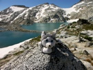
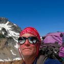
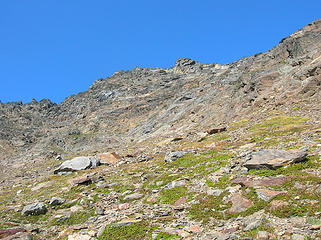 Luahna's SW face 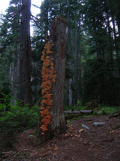 "Chicken of the forest" 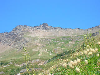 Luahna from the south 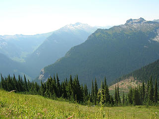 2 labels Looking SW from the upper slopes 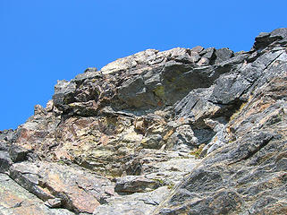 Luahna scramble at top 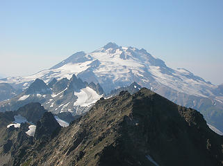 Glacier Peak from Luahna 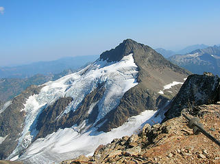 Clark from Luahna 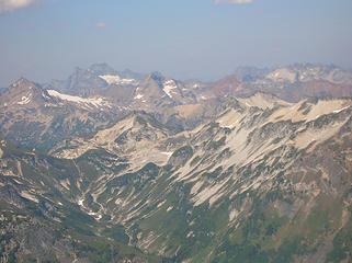 Views from Luahna 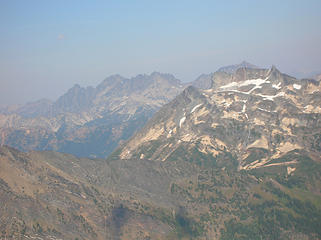 Views from Luahna 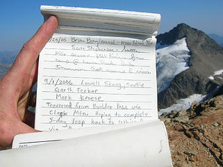 Luahna register #1 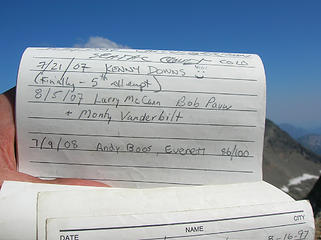 Luahna register #2 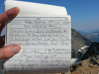 Luahna register #3 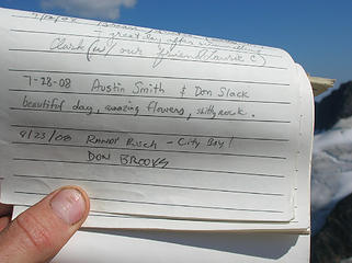 Luahna register #4 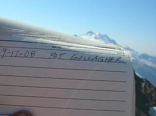 Luahna register #5 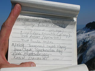 Luahna register #6 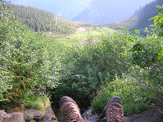 Contemplating another dive into the slide alder 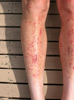 When a leg meets a ferret... 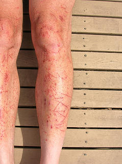 ... or a brushy outing.
|
| Back to top |
  
|
|
GeoTom
Member
Joined: 19 May 2005
Posts: 3215 | TRs | Pics
Location: Earth |
|
GeoTom
Member
|
Tue Aug 25, 2009 11:25 am |
|
|
Sounds, um...fun.
Thank you for the entertaining read. I hope not to relive your experiences however. 
|
| Back to top |
|
|
BirdDog
Member
Joined: 09 Jan 2007
Posts: 1067 | TRs | Pics
Location: Seattle |
|
BirdDog
Member
|
Tue Aug 25, 2009 11:38 am |
|
|
"good judgement comes from experience - experience comes from bad judgement" Definitely not a wasted trip.
"There can be no greater issue than that of conservation in this country."
Teddy Roosevelt August 6, 1912
"There can be no greater issue than that of conservation in this country."
Teddy Roosevelt August 6, 1912
|
| Back to top |
|
|
The Bubbly Hiker
Member

Joined: 07 Feb 2009
Posts: 375 | TRs | Pics
|
I "enjoyed" reading of your trip. I was on the 8/4 expedition but didn't summit with my two more capable compadres. We had approached via the sheepherder trail from Boulder Creek, climbed Clark, and descended towards Luahna. Things went ok up to this point. On our last day, we tried dropping down the sheepherder route and followed it about half way until running into some confusion.
At this point, the forest was open and downhill travel pretty easy. But that all changed! We tried to intersect the path where you were, at Thunder Creek... but we must have been about 10 feet away and could not see it. By this point the brush was as you describe -- thick and dense and nearly impenetrable. But we gave up on finding the ancient and venerable trail. Instead, we spent 6 hours battling the brush to go one mile. I still have scars and scratches. We all lost gear in our battle -- trekking poles, sunglasses, water bottles...
It was the worst bushwack I've ever done. Good times! Thanks for bringing up the memories!
|
| Back to top |
|
|
silence
Member

Joined: 25 Apr 2005
Posts: 4420 | TRs | Pics
|
|
silence
Member
|
Tue Aug 25, 2009 11:57 am |
|
|
well written ... most educational .. and captivating .. i read every word ... thx for sharing .. the heat last week gave us some troubs too .. not on your scale ... but enough to realize we had to scale back fm our original plans .. and water .. availability was an issue too .. anyhow i enjoyed and learned much fm your tr .. that area still intrigues me
PHOTOS
FILMS
Keep a good head and always carry a light bulb. Bob Dylan
PHOTOS
FILMS
Keep a good head and always carry a light bulb. Bob Dylan
|
| Back to top |
|
|
twodogdad
Member

Joined: 21 Nov 2006
Posts: 846 | TRs | Pics
Location: seattle |
| Roald wrote: | When a leg meets a ferret... ... or a brushy outing. |
Beautiful diptych photography, Roald
|
| Back to top |
|
|
dicey
custom title

Joined: 11 May 2004
Posts: 2870 | TRs | Pics
Location: giving cornices a wider berth |
|
dicey
custom title
|
Tue Aug 25, 2009 12:06 pm |
|
|
Nice!  Hey, at least you had views
|
| Back to top |
|
|
Randy
Cube Rat

Joined: 18 Dec 2001
Posts: 2910 | TRs | Pics
Location: Near the Siamangs |
|
Randy
Cube Rat
|
Tue Aug 25, 2009 12:11 pm |
|
|
Whoa. We need someone to carry the rope on Tupshin, so I'm glad you made it back!
Well written TR and congrats on another Top 100!
|
| Back to top |
|
|
Mtn Man
Snow addict

Joined: 13 Jan 2008
Posts: 552 | TRs | Pics
Location: Shoreline, WA |
|
Mtn Man
Snow addict
|
Tue Aug 25, 2009 12:13 pm |
|
|
This TR hurt by just reading it.....
Glad you made it out ok, albeit the cuts and lost contact.
B)
|
| Back to top |
|
|
touron
Member
Joined: 15 Sep 2003
Posts: 10293 | TRs | Pics
Location: Plymouth Rock |
|
touron
Member
|
Tue Aug 25, 2009 12:39 pm |
|
|
Touron is a nougat of Arabic origin made with almonds and honey or sugar, without which it would just not be Christmas in Spain.
|
| Back to top |
|
|
dicey
custom title
Joined: 11 May 2004
Posts: 2870 | TRs | Pics
Location: giving cornices a wider berth |
|
dicey
custom title
|
Tue Aug 25, 2009 12:55 pm |
|
|
| Roald wrote: | | No life is truly wasted. You can always serve as a bad example for someone else. |
My new favorite quote, BTW
Thanks!
|
| Back to top |
|
|
harrymalamute
Member

Joined: 26 Apr 2008
Posts: 852 | TRs | Pics
Location: Spokane |
 what bird dog said, and sorry for laughing in a few places but you did have a good sense of humor. what bird dog said, and sorry for laughing in a few places but you did have a good sense of humor.
hikes and climbs with malamute
hikes and climbs with malamute
|
| Back to top |
|
|
peltoms
Member

Joined: 13 Jul 2006
Posts: 1760 | TRs | Pics
Location: Worcester MA |
|
peltoms
Member
|
Tue Aug 25, 2009 1:39 pm |
|
|
In 1999 trying to bushwhack up from White River toward TenPeak I was defeated by the brush, no nausea, no summit, lots of bugs, lots of heat. Great determination and keeping your head when losing your guts.
|
| Back to top |
|
|
AR
724

Joined: 22 Aug 2007
Posts: 1514 | TRs | Pics
Location: Saratoga Passage |
|
AR
724
|
Tue Aug 25, 2009 1:40 pm |
|
|
"Gatorade pollution left in the woods"

...wait...are we just going to hang here or go hiking?
...wait...are we just going to hang here or go hiking?
|
| Back to top |
|
|
Stefan
Member

Joined: 17 Dec 2001
Posts: 5093 | TRs | Pics
|
|
Stefan
Member
|
Tue Aug 25, 2009 2:57 pm |
|
|
|
| Back to top |
|
|
|
|
You cannot post new topics in this forum
You cannot reply to topics in this forum
You cannot edit your posts in this forum
You cannot delete your posts in this forum
You cannot vote in polls in this forum
|
Disclosure: As an Amazon Associate NWHikers.net earns from qualifying purchases when you use our link(s). |


