| Previous :: Next Topic |
| Author |
Message |
Yana
Hater


Joined: 04 Jun 2004
Posts: 4212 | TRs | Pics
Location: Out Hating |
|
Yana
Hater
|
 Mon Sep 14, 2009 4:52 pm |
|
|
EDITED TO ADD: I'm not sure why some of the photos are displayed sideways - they are correctly rotated in flickr.  These two peaks are located near the Canadian border north of Mt. Baker. Matt has been wanting to go up there for a while, so in August he, dicey, and fwb2 went for it. Unfortunately, that attempt was thwarted before it could begin due to a meeting between a pesky rock and the oil pan of fwb2's car.
  This weekend, Matt and dicey returned for try #2 and I joined them. Unfortunately, fwb2 was not able to come.
  The approach for these peaks begins at the Twin Lakes Trailhead, seven miles up a charming dirt road. All of it is rough and bumpy and the mile after the Yellow Aster Butte Trailhead features several entertaining dips that caused some worry. When we got to the lakes, I noted that there were very few low clearance vehicles there. It is certainly possible to take a normal car (I drive a Geo Prizm), but not the most advisable method. However, parking at the YAB trailhead adds 2.5 miles of road walking each way.
  Twin Lakes was a happening place already on Saturday morning, full of car campers enjoying this beautiful locale.
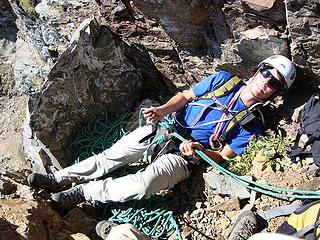
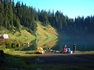 One of the Twin Lakes and an aesthetically pleasing tent 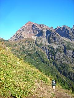 setting out toward Larrabee 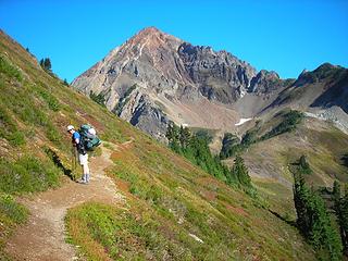 Larrabee from the trail to High Pass 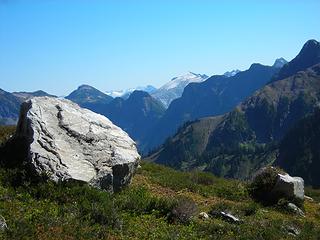 Ruth Mountain from High Pass 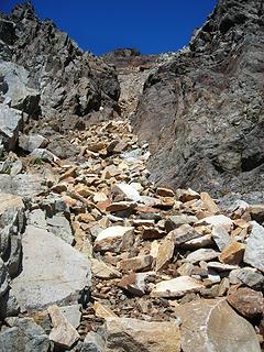 Larrabee gully 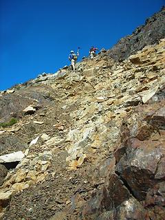 Matt and Carla on the way up 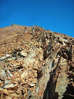 The more pleasant portion of the ascent 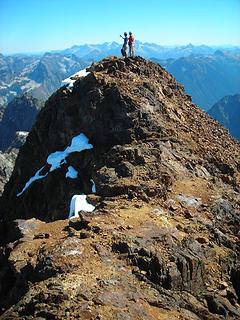 Matt and Carla on summit 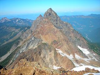 American Border Peak from summit 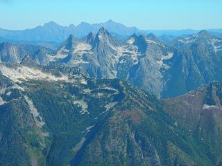 Summit views 2 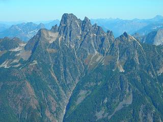 Summit Views 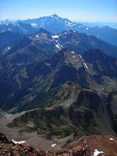 Layers 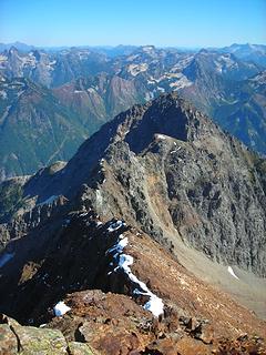 Lingering snow on Larrabee 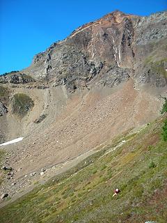 Matt gorges himself on blueberries on our descent from Larrabee 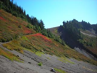 Descending from High Pass 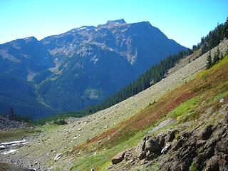 Tomyhoi Peak and the beginning of the traverse 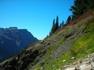 Garrett Mine Trail and Tomyhoi Peak 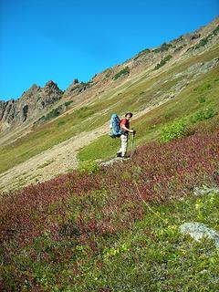 Matt on the traverse 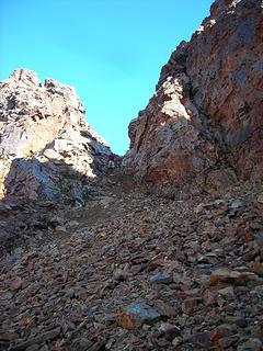 The descent from the lovely notch 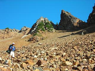 Carla expresses her feelings about the descent to camp 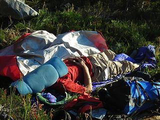 Matt's bivy setup 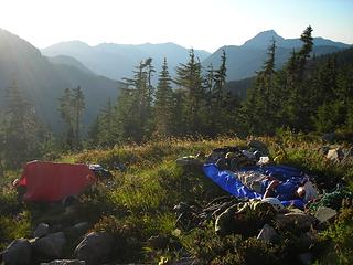 Lazing around in camp 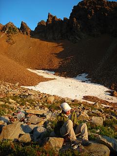 Carla at our basin camp 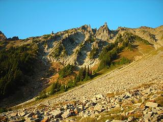 Bits of American Border to avoid on ascent 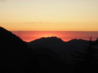 Sunset  The stars were spectacular and the silence in camp during the night was only broken periodically by the sounds of falling rock.
  Expecting a long day, we headed out of camp at 6:15. The route to the summit starts out steeply and remains so pretty much all the way to the top, with a few flatter areas for comfort. However, one of the belay stances was pretty comfortable!
 I gotcha 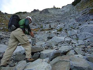 another Matt and cairn shot 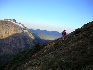 Yana and Tomyhoi 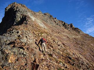 crossing the red slabs 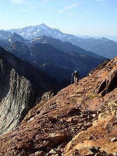 Matt and Shuksan 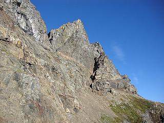 yucky scree traverse to the gully of yuck 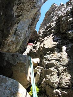 Matt works the chimney 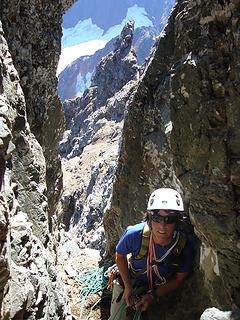 while I belay 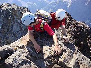 working the reverse mantle move 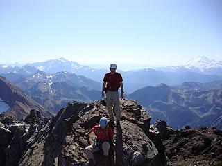 red shirt club on top 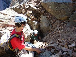 see ya Matt!! 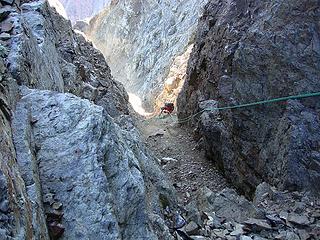 yucky gully rappel  About a mile from the trailhead, I heard some rustling just off the trail - it turned out to be a porcupine which had climbed a small tree! Pretty cool and it helped break the monotony of hiking in the dark.
We arrived back at the car at 10:40, then I had the unfortunate task of driving the endless dirt road in the dark, followed by more pleasant but also seemingly endless roads back to Seattle, finally getting home at 3 a.m. Oops!
Overall, I would say that American Border Peak and Mt. Larrabee share many things in common - both have lots of loose rock, and both offer excellent views. However, the former is much steeper and harder to approach, which might explain the fact that only about one to two parties per year climb it (if the summit register is anything to go by).
For those of you that want to enjoy the views without all that work and loose rock, take heart! Winchester Mountain, a short, easy hike on good trail from Twin Lakes offers many similar views, which begs the question: why, WHY, WHY climb those other things? If someone has the answer to that question, please let me know right away.
About a mile from the trailhead, I heard some rustling just off the trail - it turned out to be a porcupine which had climbed a small tree! Pretty cool and it helped break the monotony of hiking in the dark.
We arrived back at the car at 10:40, then I had the unfortunate task of driving the endless dirt road in the dark, followed by more pleasant but also seemingly endless roads back to Seattle, finally getting home at 3 a.m. Oops!
Overall, I would say that American Border Peak and Mt. Larrabee share many things in common - both have lots of loose rock, and both offer excellent views. However, the former is much steeper and harder to approach, which might explain the fact that only about one to two parties per year climb it (if the summit register is anything to go by).
For those of you that want to enjoy the views without all that work and loose rock, take heart! Winchester Mountain, a short, easy hike on good trail from Twin Lakes offers many similar views, which begs the question: why, WHY, WHY climb those other things? If someone has the answer to that question, please let me know right away. 
PLAY SAFE! SKI ONLY IN CLOCKWISE DIRECTION! LET'S ALL HAVE FUN TOGETHER!
PLAY SAFE! SKI ONLY IN CLOCKWISE DIRECTION! LET'S ALL HAVE FUN TOGETHER!
|
| Back to top |
  
|
|
joker
seeker

Joined: 12 Aug 2006
Posts: 7953 | TRs | Pics
Location: state of confusion |
|
joker
seeker
|
Mon Sep 14, 2009 5:06 pm |
|
|
Thanks for confirming my quick take from back when I took a walk up to High Pass and asked myself "is that climb as nasty as it looks?" And my take that making it further out to the Border Peaks was even crazier. Thanks for helping me feel even better about my feeling of contentedness at having merely summited Winchester in addition to the side-trip to High Pass  .
They sure are pretty peaks to look at during sunset from a nice perch over by Yellow Aster Butte, anyhow. .
They sure are pretty peaks to look at during sunset from a nice perch over by Yellow Aster Butte, anyhow.
|
| Back to top |
|
|
Jason Hummel
Member

Joined: 31 Aug 2006
Posts: 1209 | TRs | Pics
Location: Tacoma Washington |
Thanks for the report! The Pleiades are so cool looking from that area.
BTW, you need to try Larrabee in the winter/early spring.
|
| Back to top |
|
|
Sadie's Driver
Sadie's Driver

Joined: 24 Apr 2006
Posts: 1763 | TRs | Pics
Location: Welcome Pass |
| Yana wrote: | | which begs the question: why, WHY, WHY climb those other things? If someone has the answer to that question, please let me know right away. |
Answer: Because they're there, silly!
Lovely pics. (Excuse me while I manually twist my head/neck back to an upright position!)   s.d. s.d.
Four-paw buddy lets me tag along!
Four-paw buddy lets me tag along!
|
| Back to top |
|
|
DIYSteve
seeking hygge

Joined: 06 Mar 2007
Posts: 12655 | TRs | Pics
Location: here now |
|
DIYSteve
seeking hygge
|
Mon Sep 14, 2009 5:17 pm |
|
|
Nice work, great TR.
But my neck is stiff from looking at those damn sideways pics. 
|
| Back to top |
|
|
GeoTom
Member

Joined: 19 May 2005
Posts: 3215 | TRs | Pics
Location: Earth |
|
GeoTom
Member
|
Mon Sep 14, 2009 5:18 pm |
|
|
Looks steep. Sometimes really steep. 
|
| Back to top |
|
|
iron
Member

Joined: 10 Aug 2008
Posts: 6392 | TRs | Pics
Location: southeast kootenays |
|
iron
Member
|
Mon Sep 14, 2009 5:37 pm |
|
|
| Yana wrote: | | After sunset, we saw an amazing sight - perhaps a meteor, perhaps another object burning up in the atmosphere. It was larger, slower, and much brighter than any meteor I've ever seen, and it seemed to have two separate parts. Maybe a satellite? It was very visible, despite the fact that it wasn't really dark yet and it was in the west - precisely where the sky was lightest. Whatever it was, it was glorious. |
hotpantz and i saw the same one from our campsite near visit ridge (TR coming).
congrats on the peaks! AB looks so awesome from high pass and larabee's rich red color is inviting.
|
| Back to top |
|
|
wamtngal
Member

Joined: 13 Jun 2004
Posts: 2382 | TRs | Pics
Location: somewhere |
|
wamtngal
Member
|
Mon Sep 14, 2009 8:01 pm |
|
|
Opinions expressed here are my own.
|
| Back to top |
|
|
Tom_Sjolseth
Born Yesterday

Joined: 30 May 2007
Posts: 2652 | TRs | Pics
Location: Right here. |
Nice looking trip, people! Thanks for a great report about two peaks on my imminent list.
|
| Back to top |
|
|
the Zachster
Member

Joined: 17 Jan 2007
Posts: 4776 | TRs | Pics
Location: dog training |
Nice report! Whenever I'm in that area I look at those peaks and wonder who could enjoy that steep loose (and apparently sometimes wet!) stuff. Now I now!
We were over at Yellow Aster Butte for the weekend (did you see us  )
We shared the same lovely sunset...
And we saw the meteor thing too...AMAZING!!! )
We shared the same lovely sunset...
And we saw the meteor thing too...AMAZING!!!
"May I always be the kind of person my dog thinks I am"
"May I always be the kind of person my dog thinks I am"
|
| Back to top |
|
|
Tazz
Member
Joined: 27 Apr 2005
Posts: 7902 | TRs | Pics
|
|
Tazz
Member
|
Mon Sep 14, 2009 10:10 pm |
|
|
|
| Back to top |
|
|
EastKing
Surfing and Hiking

Joined: 28 Mar 2007
Posts: 2082 | TRs | Pics
Location: 77 miles from Seattle! |
|
EastKing
Surfing and Hiking
|
Mon Sep 14, 2009 10:41 pm |
|
|
YouTube | SummitPost
Saw the depths of despair. Now I am salvaging what time I have left on Earth.
|
| Back to top |
|
|
fwb
Member
Joined: 16 Oct 2008
Posts: 224 | TRs | Pics
Location: Mukilteo, WA |
|
fwb
Member
|
Mon Sep 14, 2009 11:38 pm |
|
|
Great TR. Glad everyone made it. I'm still bummed I couldn't go (and bummed as well... just got the bill from last time -ouch). My mind says I gotta' go, but the docs are keeping a close eye... I'm getting tired of baring a cheek...
|
| Back to top |
|
|
Randy
Cube Rat

Joined: 18 Dec 2001
Posts: 2910 | TRs | Pics
Location: Near the Siamangs |
|
Randy
Cube Rat
|
Tue Sep 15, 2009 9:24 am |
|
|
Nicely written TR, Yana. One for the list.
|
| Back to top |
|
|
pimaCanyon
Member

Joined: 13 Jul 2007
Posts: 1304 | TRs | Pics
Location: at the bottom of the map |
Yana, you, Carla, and Matt sure know how to have a good time!
Great TR, Yana, as always. Informative but also very funny in places. The one that had me laughing out loud though was when I clicked on the picture with the caption "Carla expresses her feelings about the descent to camp".
It's never too late to have a happy childhood
It's never too late to have a happy childhood
|
| Back to top |
|
|
|
|
You cannot post new topics in this forum
You cannot reply to topics in this forum
You cannot edit your posts in this forum
You cannot delete your posts in this forum
You cannot vote in polls in this forum
|
Disclosure: As an Amazon Associate NWHikers.net earns from qualifying purchases when you use our link(s). |


