| Previous :: Next Topic |
| Author |
Message |
daffish
Member


Joined: 16 Sep 2009
Posts: 282 | TRs | Pics
Location: Dreamtime |
|
daffish
Member
|
 Wed Sep 16, 2009 10:00 pm |
|
|
The route is an old sheepherders trail that traverses through the high basins along the SE ridge of Fortress Mtn. The 1965 book Routes and Rocks has a description that is still a good guide to follow. Not much seems to have changed since the authors surveyed the route long ago.
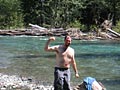
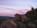
My first day was a long haul up the Buck Creek Trail until continuing on a good path to the meadow below Pass No Pass and a campsite in the trees.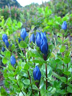 Mountain Gentian in Pass No Pass meadow 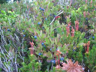 berry delicious 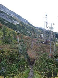 start of high route trail 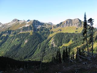 morning on Liberty Cap 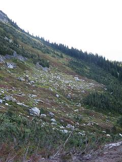 the high route contours upwards 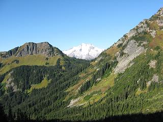 Glacier Peak above Buck Creek Pass 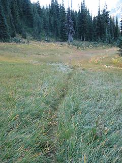 trail thru a meadow 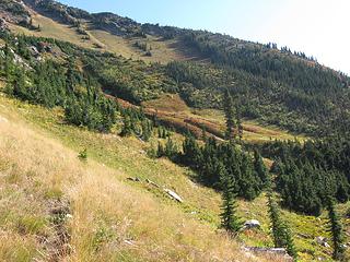 around a spur into another basin 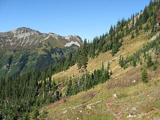 faint path on the slopes 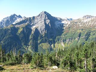 Mt Cleator across the valley 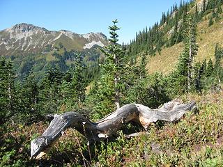 along the high route 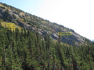 route finding thru the cliffs 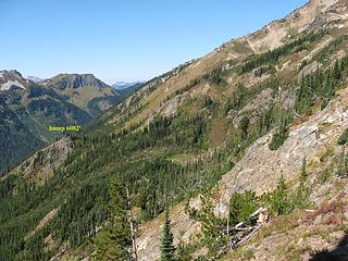 above the cliffs looking back at 6082 hump 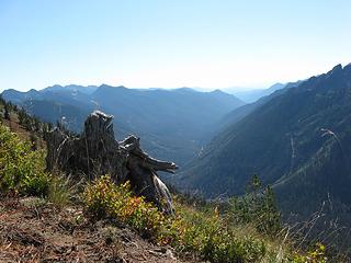 view down Buck Creek Valley 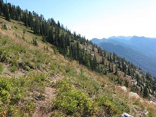 traversing open slopes 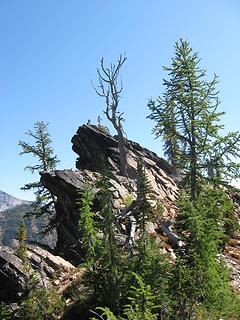 rock promontory at ridge 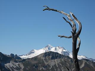 view from the ridge 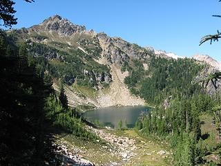 Massie Lake 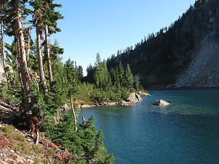 Massie Lake shoreline 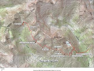 Massie Lake High Route 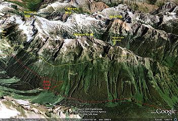 Google view of High Route
"Be moderate in everything, including moderation" Horace Porter
"Be moderate in everything, including moderation" Horace Porter
|
| Back to top |
  
|
|
Kim Brown
Member

Joined: 13 Jul 2009
Posts: 6899 | TRs | Pics
|
Damn. Nice trip report. R&R rocks. 
"..living on the east side of the Sierra world be ideal - except for harsher winters and the chance of apocalyptic fires burning the whole area."
Bosterson, NWHiker's marketing expert
"..living on the east side of the Sierra world be ideal - except for harsher winters and the chance of apocalyptic fires burning the whole area."
Bosterson, NWHiker's marketing expert
|
| Back to top |
|
|
Hanzsek
Member

Joined: 13 Sep 2009
Posts: 37 | TRs | Pics
Location: Snohomish |
|
Hanzsek
Member
|
Wed Sep 16, 2009 10:54 pm MLHR
|
|
|
I (and a partner) had come through that route exactly that you took two days prior. We saw you had signed the trail register as we exited. That was our boot prints at the top of the scruffy little gully, too. Did you happen to find my friend's pocket knife that he left on top the 6082' knob? Have any trouble picking up the trail to cross the river? We hemmed and hawed a bit before deciding to trust the altimeter and compass...
|
| Back to top |
|
|
Dayhike Mike
Bad MFKer
Joined: 02 Mar 2003
Posts: 10958 | TRs | Pics
Location: Going to Tukwila |
Great first post! Thanks for the trip report! I'd like to do this one myself one day.
"There is only one basic human right, the right to do as you damn well please. And with it comes the only basic human duty, the duty to take the consequences." -P.J. O'Rourke
"Ignorance is natural. Stupidity takes commitment." -Solomon Short
"There is only one basic human right, the right to do as you damn well please. And with it comes the only basic human duty, the duty to take the consequences." -P.J. O'Rourke
"Ignorance is natural. Stupidity takes commitment." -Solomon Short
|
| Back to top |
|
|
puzzlr
Mid Fork Rocks

Joined: 13 Feb 2007
Posts: 7220 | TRs | Pics
Location: Stuck in the middle |
|
puzzlr
Mid Fork Rocks
|
Thu Sep 17, 2009 2:02 am |
|
|
on the illustrated photos and maps.
We did a trip that crossed the Fortress south ridge a few years ago and I never figured out where the Massie HR went (we weren't trying to follow it). Great report. Isn't that area fantastic in good weather!
|
| Back to top |
|
|
DIYSteve
seeking hygge

Joined: 06 Mar 2007
Posts: 12655 | TRs | Pics
Location: here now |
|
DIYSteve
seeking hygge
|
Thu Sep 17, 2009 7:37 am |
|
|
Welcome.  Excellent. MLHR is on my list. Gotta luv Tabor & Crowder. Excellent. MLHR is on my list. Gotta luv Tabor & Crowder.
|
| Back to top |
|
|
silence
Member

Joined: 25 Apr 2005
Posts: 4420 | TRs | Pics
|
|
silence
Member
|
Thu Sep 17, 2009 8:34 am |
|
|
sweet .... very sweet .. way to get out there and do something different .. i'm jealous
hey chris (hanzsek) .. i just realized that was you .. howdy pal .. great to see you out there too .. where's your pix???? we gotta get together for a hike sometime -- kathy 
PHOTOS
FILMS
Keep a good head and always carry a light bulb. Bob Dylan
PHOTOS
FILMS
Keep a good head and always carry a light bulb. Bob Dylan
|
| Back to top |
|
|
wamtngal
Member

Joined: 13 Jun 2004
Posts: 2382 | TRs | Pics
Location: somewhere |
|
wamtngal
Member
|
Thu Sep 17, 2009 8:44 am |
|
|
Very nice! Have had the MLHR on my list for quite awhile now...thanks for the great detail too.
Opinions expressed here are my own.
Opinions expressed here are my own.
|
| Back to top |
|
|
silence
Member
Joined: 25 Apr 2005
Posts: 4420 | TRs | Pics
|
|
silence
Member
|
Thu Sep 17, 2009 8:45 am |
|
|
btw .. anyone .. i have the maps/pdfs for the challenger and glacier peaks quads of r & r but nothing for that area or chelan .. did i miss them?? are these also posted online and where again?
PHOTOS
FILMS
Keep a good head and always carry a light bulb. Bob Dylan
PHOTOS
FILMS
Keep a good head and always carry a light bulb. Bob Dylan
|
| Back to top |
|
|
Schroder
Member

Joined: 26 Oct 2007
Posts: 6719 | TRs | Pics
Location: on the beach |
|
Schroder
Member
|
Thu Sep 17, 2009 9:01 am |
|
|
This area is in the same book (Routes & Rocks) and you can download it from Tabor's site
|
| Back to top |
|
|
Malamonster1
Member
Joined: 25 Jun 2009
Posts: 20 | TRs | Pics
|
Yeah, we also did this route starting on the 11th with our Malamute. Spent the first night at Helmut Butte after bushwacking over avy debris instead of walking a couple more miles to Buck Pass and then over. The next day we too ran into that gigantic slide path. Took awhile to get through there. We came in north of Massie lake vs. traversing further to the south where the trail actually goes. It was a more direct route but we had to down climb that steep scree/talus/heather field on the north side of the lake. Beautiful lake!! We couldnt believe we were the only ones there on such a great weekend.
We didnt find a pocket knife. However, if someone's heads that way I left my eye glasses at the nothern most campsite at the lake. They are black titanium.
|
| Back to top |
|
|
Tom
Admin
Joined: 15 Dec 2001
Posts: 17851 | TRs | Pics
|
|
Tom
Admin
|
Thu Sep 17, 2009 11:18 am |
|
|
Love the labels on the map.
"no path or possible animal trail" 
|
| Back to top |
|
|
HitTheTrail
Member

Joined: 30 Oct 2007
Posts: 5455 | TRs | Pics
Location: 509 |
I was actually thinking of dayhiking or doing a one-nighter to Massie Lake next week. How is the Chiwawa River crossing?
|
| Back to top |
|
|
Hanzsek
Member
Joined: 13 Sep 2009
Posts: 37 | TRs | Pics
Location: Snohomish |
|
Hanzsek
Member
|
Thu Sep 17, 2009 1:32 pm Chiwawa crossing
|
|
|
Crossing the Chiwawa was short and easy once you find the vicinity to cross... We got suckered into following a trail remnant northward along the river thinking it would lead us to an easy crossing and efficient boot path beyond but it kept going - probably an abandoned river trail. There are two pieces of flagging on the trees marking the spot. Once across we found additional trail remnants but no clear route up to intersect the Chiwawa River trail. We just went the path of least resistance in a ENE direction and that worked well.
|
| Back to top |
|
|
daffish
Member
Joined: 16 Sep 2009
Posts: 282 | TRs | Pics
Location: Dreamtime |
|
daffish
Member
|
Thu Sep 17, 2009 3:23 pm |
|
|
Crossing the Chiwawa is easy. Here is what it looked like when I came across -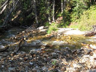 Chiwawa River crossing
"Be moderate in everything, including moderation" Horace Porter
"Be moderate in everything, including moderation" Horace Porter
|
| Back to top |
|
|
|
|


