| Previous :: Next Topic |
| Author |
Message |
wildernessed
viewbagger


Joined: 31 Oct 2004
Posts: 9275 | TRs | Pics
Location: Wenatchee |
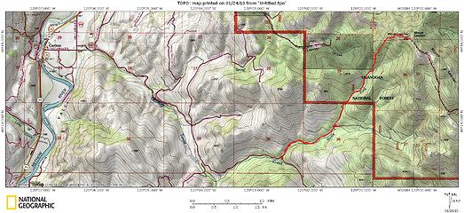
Location : East of Carlton, Wa. off SR 97
Access : See attached map ( 97 > Old Carlton Rd > Texas Creek Rd )
Maps : TOPO
Stats : 6.7 mi, 2650 r/t
 Mt. Leecher 5020'  . There is a pullout right by the forest rd. we planned on taking, probably used by xc skiers and snowshoers. The approach we took had us on State, then National Forest land.
We didnt bring any snowshoes (which we always do) figuring though we were farther North, we were pretty far East, and it was an El Nino year. I figured if anything we might need crampons, but we decided after talking to a xc skier we didnt need them, but she was pretty surprised we didnt bring snowshoes . There is a pullout right by the forest rd. we planned on taking, probably used by xc skiers and snowshoers. The approach we took had us on State, then National Forest land.
We didnt bring any snowshoes (which we always do) figuring though we were farther North, we were pretty far East, and it was an El Nino year. I figured if anything we might need crampons, but we decided after talking to a xc skier we didnt need them, but she was pretty surprised we didnt bring snowshoes  . I figured well here we are, weve postholed before for miles so its our mess and well have to live with it. . I figured well here we are, weve postholed before for miles so its our mess and well have to live with it.  The road early on was still hard from the nights freeze and we made good time until maybe half a mile before our ridge turn off then every step was initial weight baring, break through the crust, then sink down a foot. Steve did much better weighing 25 lbs. less than me and having bigger feet. We eventually turned off onto the ridge and it was much the same with snow increasing in depth. The ridge wasnt what I expected it was wide, then narrow, rather open, with a lot of brush, and huge rock formations you had to skirt around, some 20-30 high. The snow depth changed to 2-4 deep and to more of a powder I was often up to my thighs, waist, and chest rocking with each step to widen my step ahead and get some momentum
  . The route itself was low angle. More snow, than I expected this far East and at this altitude ( but it is January ). . The route itself was low angle. More snow, than I expected this far East and at this altitude ( but it is January ).
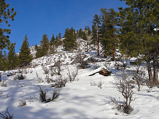 Lower ridge entry point. 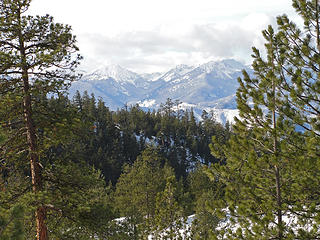 Looking up the Foggy Dew Drainage from the SSW ridge going up Leecher. 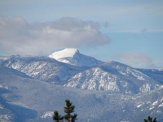 Oval Peak 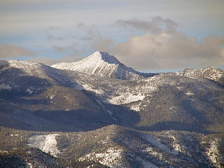 Hoodoo Peak 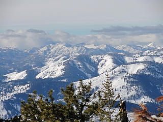 The more we struggle, the higher we get, the more obscured the views. We miss high pressure over here. 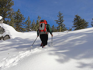 Steve 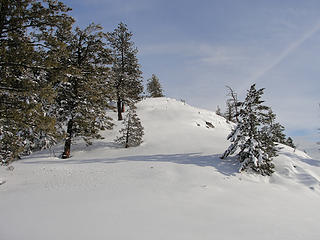 Pushing up through deep powder to the final summit ridge / lookout area. 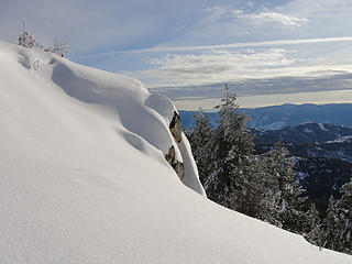 On the map the ridge looks quite straightforward, but it undulated and there are quite a few large rock formations that you have to skirt around.  Wowza ! I still hate snowshoes, but this is definitely a ridge run that should be considered, especially in the Spring with the open ridge, rock formation, wild flowers, and views from the Columbia River to Isabella Ridge and beyond. Wowza ! I still hate snowshoes, but this is definitely a ridge run that should be considered, especially in the Spring with the open ridge, rock formation, wild flowers, and views from the Columbia River to Isabella Ridge and beyond.
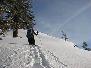 Rob struggling through the snow at a snails pace 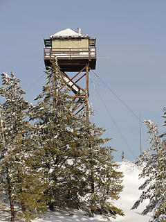 Mt. Leecher Lookout 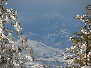 Goat Peak above Mazama. Earlier in the day we could see Old Goat from near the Columbia River and all the peaks between and beyond The Craggies. This is a great ridge run. 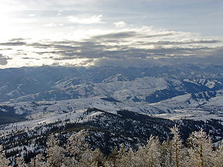 Once on the summit clouds generally obscured most peaks to the West. 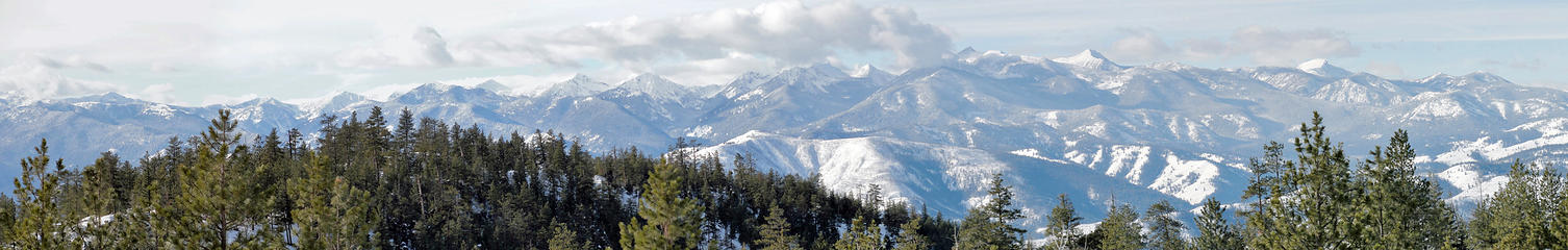 Ridgeline Pano 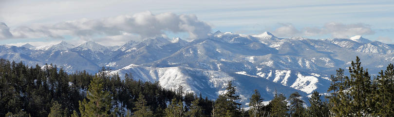 Ridgeline Pano II 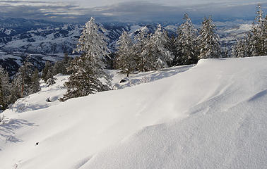 Snowbound Summit Area
Living in the Anthropocene
Living in the Anthropocene
|
| Back to top |
  
|
|
Hiker Mama
Member

Joined: 25 Jun 2006
Posts: 3451 | TRs | Pics
Location: Lynnwood |
That sun looks beautiful! Way to struggle through the snow. I don't think I would have persevered that long.
|
| Back to top |
|
|
wildernessed
viewbagger
Joined: 31 Oct 2004
Posts: 9275 | TRs | Pics
Location: Wenatchee |
Sunny days have been very few East of the crest for months, so it was nice. The route and summit were prisitine, I don't beleive anyone has been up there this winter.
Living in the Anthropocene
Living in the Anthropocene
|
| Back to top |
|
|
Get Out and Go
Member

Joined: 13 Nov 2004
Posts: 2128 | TRs | Pics
Location: Leavenworth |
Interesting, now you're checking out new terrain on the "East" side of the Methow River......But wait! Why didn't you just take that "well-worn boot-path" up to the summit? 
"These are the places you will find me hiding'...These are the places I will always go."
(Down in the Valley by The Head and The Heart)
"Sometimes you're happy. Sometimes you cry.
Half of me is ocean. Half of me is sky."
(Thanks, Tom Petty)
"These are the places you will find me hiding'...These are the places I will always go."
(Down in the Valley by The Head and The Heart)
"Sometimes you're happy. Sometimes you cry.
Half of me is ocean. Half of me is sky."
(Thanks, Tom Petty)
|
| Back to top |
|
|
wildernessed
viewbagger
Joined: 31 Oct 2004
Posts: 9275 | TRs | Pics
Location: Wenatchee |
There are quite a few accessible quiet peaks and ridges with good views up that way might as well take advantage of them. 
Living in the Anthropocene
Living in the Anthropocene
|
| Back to top |
|
|
Hikingqueen
Member

Joined: 12 Nov 2007
Posts: 2946 | TRs | Pics
|
Gorgeous pics! Thank you for sharing!
|
| Back to top |
|
|
|
|
You cannot post new topics in this forum
You cannot reply to topics in this forum
You cannot edit your posts in this forum
You cannot delete your posts in this forum
You cannot vote in polls in this forum
|
Disclosure: As an Amazon Associate NWHikers.net earns from qualifying purchases when you use our link(s). |


