| Previous :: Next Topic |
| Author |
Message |
Yana
Hater


Joined: 04 Jun 2004
Posts: 4212 | TRs | Pics
Location: Out Hating |
|
Yana
Hater
|
 Tue Feb 09, 2010 2:40 am |
|
|
With the weather forecast for the foreseeable future in the Mt. Baker area suggesting "partly sunny," I tricked dicey into agreeing on a three day trip. I threw out some suggestions and we agreed on Ruth Mountain and Icy Peak. Dicey has been to both before, Ruth more than once, but was happy to return. She and I were actually planning on Ruth and Icy a couple of years ago on our way back from Mt. Challenger but terrible weather forced us to abort that attempt before it even really began.
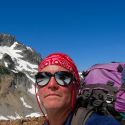
We thought this might be a good time to visit this locale as the road is drivable almost all the way to the Hannegan Pass trailhead! Not having five miles of roadwalking was really appealing for some reason.  Some high clearance vehicles had even made it all the way to the trailhead, but the last half mile is deeply rutted snow that my Geo Prizm was happy to avoid. In fact, there were three more cars up there than I was expecting to see (i.e., three total). We set off up the road at around 8:30, loaded with heavy packs full of all kinds of crap!
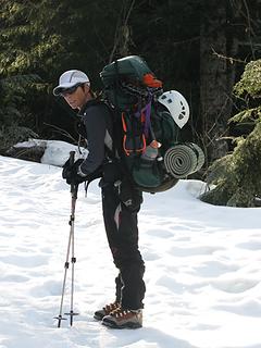 Carla and her giant pack are ready to go! 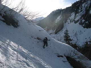 Charming icy gully crossing on the eternal traverse 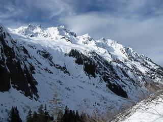 Mt. Sefrit from the trail to Hannegan Pass  Eventually, after what seems like several lifetimes of treading across avalanche debris and a generally pathetic snowpack, the trail enters the forest. This is a relief from the debris but is uncomfortably icy and slanted in a couple of sections. We donned snowshoes somewhere along this stretch, which helped both the postholing and the iciness.
It seems that this has mainly been a skier locale, as there were no other snowshoe tracks, just skin tracks and occasional bootprints from the people ahead.
Around 4400', the trail breaks out into a flattish area below Hannegan Pass. We made our way up toward the pass to follow the summer route to Ruth Mountain while some of the skin tracks continued a rising traverse toward Ruth. This is when we discovered that the snow conditions were such that we could really only go up very gentle snowslopes without slithering backward.
Eventually, after what seems like several lifetimes of treading across avalanche debris and a generally pathetic snowpack, the trail enters the forest. This is a relief from the debris but is uncomfortably icy and slanted in a couple of sections. We donned snowshoes somewhere along this stretch, which helped both the postholing and the iciness.
It seems that this has mainly been a skier locale, as there were no other snowshoe tracks, just skin tracks and occasional bootprints from the people ahead.
Around 4400', the trail breaks out into a flattish area below Hannegan Pass. We made our way up toward the pass to follow the summer route to Ruth Mountain while some of the skin tracks continued a rising traverse toward Ruth. This is when we discovered that the snow conditions were such that we could really only go up very gentle snowslopes without slithering backward.
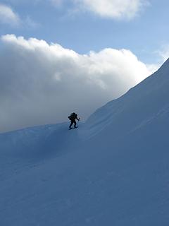
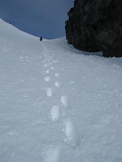
 Near Hannegan Pass 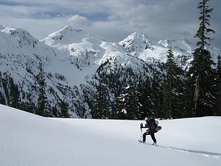 Carla admires the Mt. Sefrit massif  We took a brief break and considered the route ahead - a steep few hundred feet that dicey had described as a "wall of mud" on our last trip to Hannegan Pass. "Wall of Snow" may not sound nearly as disgusting and unpleasant, but in fact we could not actually snowshoe up it. Oh, we tried. First we hit it head on - slithering ensued. Then we tried angling - no luck. Finally, we just had to take the snowshoes off and boot up. This was exhausting but at least it worked!
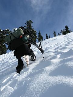 Kicking steps up the steep slope  At the top of the slope we once more donned the snowshoes and proceeded with a traverse around a high point between Ruth Mountain and Hannegan Pass. This area would be pretty hinky in terms of avalanche potential if conditions were not stable. We turned a corner, having to climb over a forming cornice, and got our first closeup look of Ruth Mountain and the rest of the route. We could see the group of skiers/snowboarders whose tracks we'd seen diverge earlier heading up toward the summit.
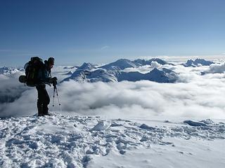
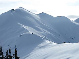 Ruth Mountain finally looks a bit closer! 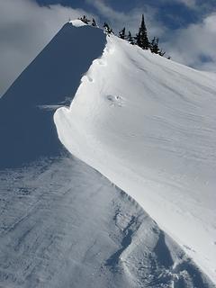 Interesting bit of Ruth ridge 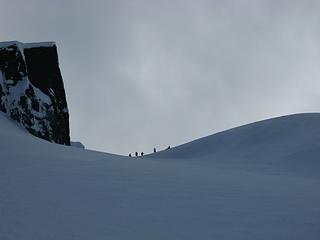 Skiers and Snowboarders get ready to descend 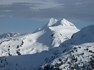 Whatcom Peak  ). I turned to watch them once in a while and they would stop and stand around for quite some time, apparently in no hurry despite the fact that it was past 3:30.
We arrived at the summit of Ruth Mountain at four o'clock, seven and a half hours after leaving the trailhead. Yikes! ). I turned to watch them once in a while and they would stop and stand around for quite some time, apparently in no hurry despite the fact that it was past 3:30.
We arrived at the summit of Ruth Mountain at four o'clock, seven and a half hours after leaving the trailhead. Yikes!
 Nearing the summit of Ruth Mountain 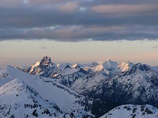 The sun sets on Canada 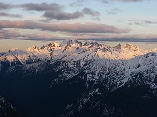 Sunset from the summit of Ruth  It hadn't been hideously cold overnight, but this didn't prevent my boots from freezing, so I had a really entertaining time shoving my feet into them in the morning.
Though it started out pretty socked in, as the morning progressed mountains appeared one by one.
It hadn't been hideously cold overnight, but this didn't prevent my boots from freezing, so I had a really entertaining time shoving my feet into them in the morning.
Though it started out pretty socked in, as the morning progressed mountains appeared one by one.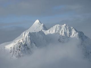 Mount Shuksan peeks 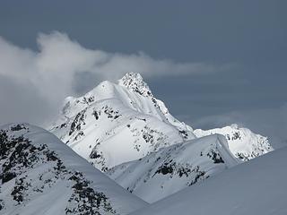 Mt. Sefrit frolicks with the clouds 
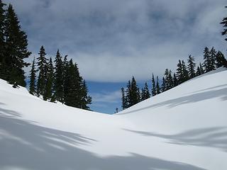
 Down the gully 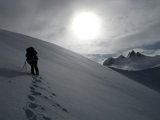 Heading toward Icy 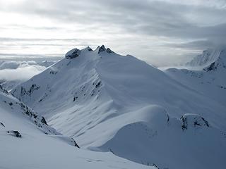 Nice, clear weather 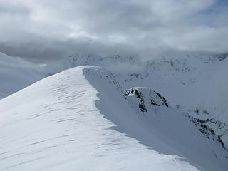 Windswept ridge and a bit of sunlight 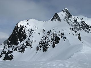 Our route toward Icy Peak 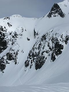 Gully footprints 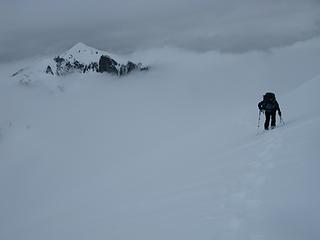 Near the top of the Icy Glacier, Ruth Mountain in the background 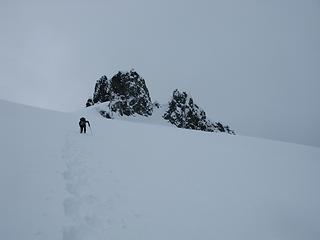 Heading up the Icy Glacier 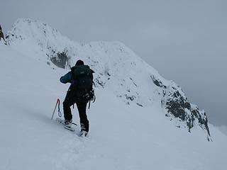 Carla and a brief glimpse of the summit of Icy Peak 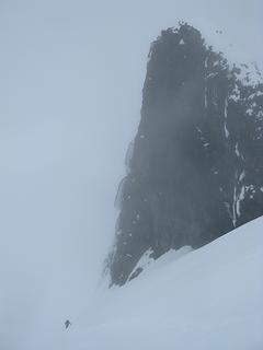 Traversing below bits of Icy Peak 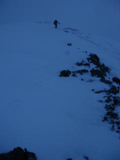 Returning to camp with the last of the daylight  Carla starts a fire to keep us warm 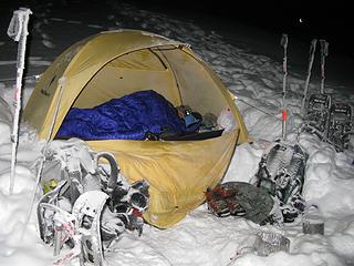 Snowy camp area. Carla tries to stay warm. 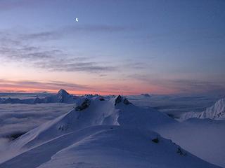 Icy Peak and the moon 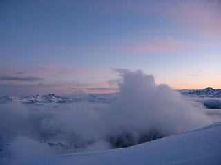 Giant cloud monster is coming to eat us! 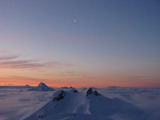 smRuthIcy 224 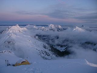 Camp at dawn 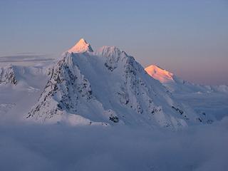 Shuksan and Baker turn shocking pink 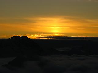 Sunrise 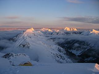 Camp and the Ruth Creek Valley 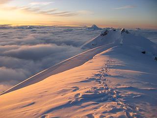 Icy Peak and the summit ridge of Ruth 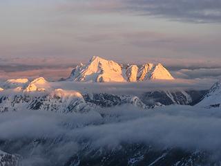 Mt. Larrabee 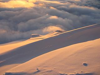 Snow and clouds 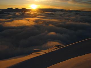 Good morning, starshine! 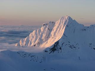 Seahpo Peak 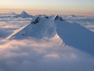 Icy Peak in the morning 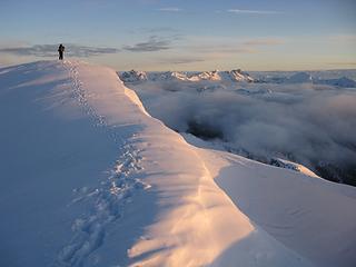 Carla photographs the spectacle 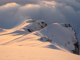 Lit up ridge 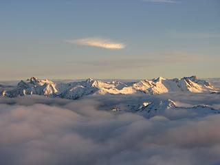 Mountains and funky cloud 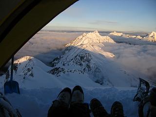 The view of our feet from the tent. Oh, and some other stuff, too. 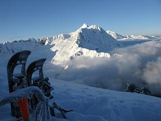 Snowshoes, Shuksan, and Baker 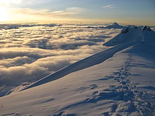 Morning! 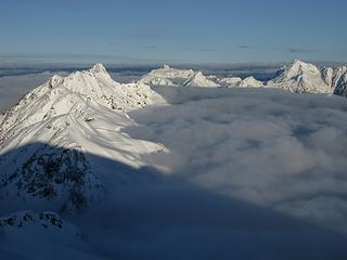 Silent cloud monster attacks Sefrit 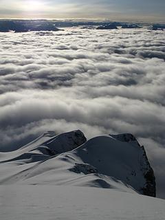 Clouds fill the lower elevations 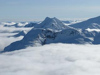 Whatcom Peak rises above the clouds 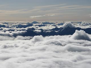 Mountains asea 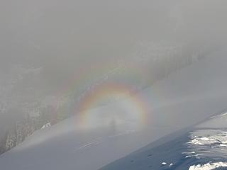 Oh glory, glory!  Eventually, it was time to leave.
 Carla gets ready to leave the summit 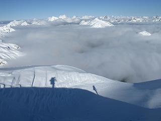 Shadows descend from Ruth summit 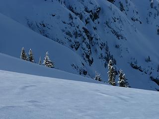 Snowy trees 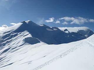 One last look at Ruth 
 Click here to view morning summit pano video
PLAY SAFE! SKI ONLY IN CLOCKWISE DIRECTION! LET'S ALL HAVE FUN TOGETHER!
PLAY SAFE! SKI ONLY IN CLOCKWISE DIRECTION! LET'S ALL HAVE FUN TOGETHER!
|
| Back to top |
  
|
|
Magellan
Brutally Handsome

Joined: 26 Jul 2006
Posts: 13116 | TRs | Pics
Location: Inexorable descent |
|
Magellan
Brutally Handsome
|
Tue Feb 09, 2010 3:44 am |
|
|
|
| Back to top |
|
|
EastKing
Surfing and Hiking

Joined: 28 Mar 2007
Posts: 2082 | TRs | Pics
Location: 77 miles from Seattle! |
|
EastKing
Surfing and Hiking
|
Tue Feb 09, 2010 6:09 am |
|
|
Incredible Trip!!! You both always have the best trips. Keep them coming!
YouTube | SummitPost
Saw the depths of despair. Now I am salvaging what time I have left on Earth.
YouTube | SummitPost
Saw the depths of despair. Now I am salvaging what time I have left on Earth.
|
| Back to top |
|
|
Redwic
Unlisted Free Agent

Joined: 23 Feb 2009
Posts: 3292 | TRs | Pics
Location: Going to the Prom(inence) |
|
Redwic
Unlisted Free Agent
|
Tue Feb 09, 2010 6:36 am |
|
|
Great trip report! Great photos!
60 pounds lighter but not 60 points brighter.
60 pounds lighter but not 60 points brighter.
|
| Back to top |
|
|
Tazz
Member

Joined: 27 Apr 2005
Posts: 7902 | TRs | Pics
|
|
Tazz
Member
|
Tue Feb 09, 2010 7:34 am |
|
|
I hate both of you! 
|
| Back to top |
|
|
kleet
meat tornado

Joined: 06 Feb 2002
Posts: 5303 | TRs | Pics
Location: O no they dih ent |
|
kleet
meat tornado
|
Tue Feb 09, 2010 8:05 am |
|
|
A fuxk, why do I not give one?
|
| Back to top |
|
|
silence
Member

Joined: 25 Apr 2005
Posts: 4420 | TRs | Pics
|
|
silence
Member
|
Tue Feb 09, 2010 8:17 am |
|
|
FANTASTIC TR AND PHOTOS (too many great ones to pick a fave) .. awesome work .. you guys rock!!!
ruth is such a beauty .. fond memories .. thx for the revisit
PHOTOS
FILMS
Keep a good head and always carry a light bulb. Bob Dylan
PHOTOS
FILMS
Keep a good head and always carry a light bulb. Bob Dylan
|
| Back to top |
|
|
Sadie's Driver
Sadie's Driver

Joined: 24 Apr 2006
Posts: 1763 | TRs | Pics
Location: Welcome Pass |
Glorious! Calendar shots indeed!  s.d. s.d.
Four-paw buddy lets me tag along!
Four-paw buddy lets me tag along!
|
| Back to top |
|
|
JimK
Member

Joined: 07 Feb 2002
Posts: 5606 | TRs | Pics
Location: Ballard |
|
JimK
Member
|
Tue Feb 09, 2010 8:43 am |
|
|
I'm glad you crawled out of the tent into that icy cold. Really nice morning shots! Ridiculous that you were able to get up there safely in early February.
|
| Back to top |
|
|
DIYSteve
seeking hygge

Joined: 06 Mar 2007
Posts: 12655 | TRs | Pics
Location: here now |
|
DIYSteve
seeking hygge
|
Tue Feb 09, 2010 8:50 am |
|
|
Cool trip. Fun TR and tasty pics, Yana. It's a great early summer route, a mere day trip for you two. Quite ballsy to try it mid-winter.
|
| Back to top |
|
|
loper
Member
Joined: 11 Aug 2007
Posts: 453 | TRs | Pics
Location: seeking the sun |
|
loper
Member
|
Tue Feb 09, 2010 8:57 am |
|
|
Wow!! Goood job!
I have been wondering about R/I with the low snow year. We did Ruth but not Icy last August and camped between the two. I defintitely want to go back and finish Icy this next year!
Thanks for the pictures.
Lisa
|
| Back to top |
|
|
Layback
Cascades Expatriate

Joined: 16 Mar 2007
Posts: 5712 | TRs | Pics
Location: Back East |
|
Layback
Cascades Expatriate
|
Tue Feb 09, 2010 9:00 am |
|
|
Hell yeah guys!!! What a great idea for a trip this time of year!!! Awesome pics!!!
|
| Back to top |
|
|
BirdDog
Member
Joined: 09 Jan 2007
Posts: 1067 | TRs | Pics
Location: Seattle |
|
BirdDog
Member
|
Tue Feb 09, 2010 9:13 am |
|
|
Great TR, nicely written and very entertaining. Nice pics too. Way to go gals!
"There can be no greater issue than that of conservation in this country."
Teddy Roosevelt August 6, 1912
"There can be no greater issue than that of conservation in this country."
Teddy Roosevelt August 6, 1912
|
| Back to top |
|
|
iron
Member

Joined: 10 Aug 2008
Posts: 6392 | TRs | Pics
Location: southeast kootenays |
|
iron
Member
|
Tue Feb 09, 2010 9:52 am |
|
|
good stuff yana & dicey! we were thinking of attempting a day trip up there this past saturday. sounds like it would've have been a bit much, especially with the enjoyable traverse.
i can't believe it only got down to 24 degrees inside your tent... on february 6th!!!
way to be ambitious!
|
| Back to top |
|
|
Yana
Hater
Joined: 04 Jun 2004
Posts: 4212 | TRs | Pics
Location: Out Hating |
|
Yana
Hater
|
Tue Feb 09, 2010 11:00 am |
|
|
| iron wrote: | | i can't believe it only got down to 24 degrees inside your tent... on february 6th!!! |
19, actually.
You could do Ruth as a day trip with an earlier start and a pack that didn't weigh 45 lbs.
PLAY SAFE! SKI ONLY IN CLOCKWISE DIRECTION! LET'S ALL HAVE FUN TOGETHER!
PLAY SAFE! SKI ONLY IN CLOCKWISE DIRECTION! LET'S ALL HAVE FUN TOGETHER!
|
| Back to top |
|
|
|
|
You cannot post new topics in this forum
You cannot reply to topics in this forum
You cannot edit your posts in this forum
You cannot delete your posts in this forum
You cannot vote in polls in this forum
|
Disclosure: As an Amazon Associate NWHikers.net earns from qualifying purchases when you use our link(s). |


