| Previous :: Next Topic |
| Author |
Message |
JimK
Member


Joined: 07 Feb 2002
Posts: 5606 | TRs | Pics
Location: Ballard |
|
JimK
Member
|
 Sat Apr 24, 2004 10:23 pm |
|
|
The flowers on Umtanum Ridge are just nearing their peak. What a show! I managed to take 227 photos in only 7 hours. Yellow and blue are the main colors but the cactus are also nearing full bloom. Well worth 260 miles of driving from North Seattle.
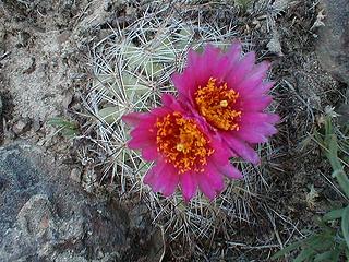 Cactus In Full Bloom 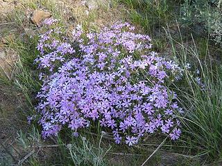 Blue Flowers 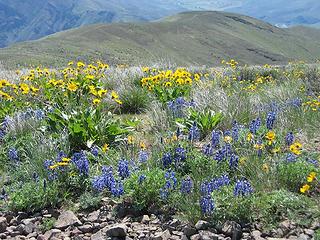 Ridge Top 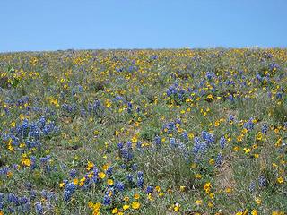 Flowers Everywhere
|
| Back to top |
  
|
|
Dean
(aka CascadeHiker)

Joined: 02 Mar 2002
Posts: 1967 | TRs | Pics
Location: ex Kennewick, Wa & Lehi Utah |
|
Dean
(aka CascadeHiker)
|
Sun Apr 25, 2004 6:20 am |
|
|
Great pics Jim. 
|
| Back to top |
|
|
Newt
Short Timer

Joined: 21 Dec 2001
Posts: 3176 | TRs | Pics
Location: Down the road and around the corner |
|
Newt
Short Timer
|
Sun Apr 25, 2004 6:22 am |
|
|
I agree And nice weather to boot?
Newt
It's pretty safe to say that if we take all of man kinds accumulated knowledge, we still don't know everything. So, I hope you understand why I don't believe you know everything. But then again, maybe you do.
It's pretty safe to say that if we take all of man kinds accumulated knowledge, we still don't know everything. So, I hope you understand why I don't believe you know everything. But then again, maybe you do.
|
| Back to top |
|
|
John
Member
Joined: 28 May 2003
Posts: 143 | TRs | Pics
Location: Edmonds |
|
John
Member
|
Sun Apr 25, 2004 10:14 pm |
|
|
Nice pictures, Jim!
I wanted to thank you, Pika, Alan and others for your inspiring reports on this area. It motivated me to make the two hour drive over the mountains to check it out myself. Very glad I did.
Thanks!
And we must have just missed each other! Here are some photos I took on Saturday:
http://www.johnandkristie.com/index.html?20040424-01.html
|
| Back to top |
|
|
JimK
Member
Joined: 07 Feb 2002
Posts: 5606 | TRs | Pics
Location: Ballard |
|
JimK
Member
|
Tue Apr 27, 2004 4:24 pm |
|
|
John,
I'm surprised I didn't see you. I guess I spent too long down the end of the ridge taking photos. Yours are very nice.
I now have all 50 photos up at: Umtanum Photos
|
| Back to top |
|
|
John
Member
Joined: 28 May 2003
Posts: 143 | TRs | Pics
Location: Edmonds |
|
John
Member
|
Tue Apr 27, 2004 8:02 pm |
|
|
Hey Jim,
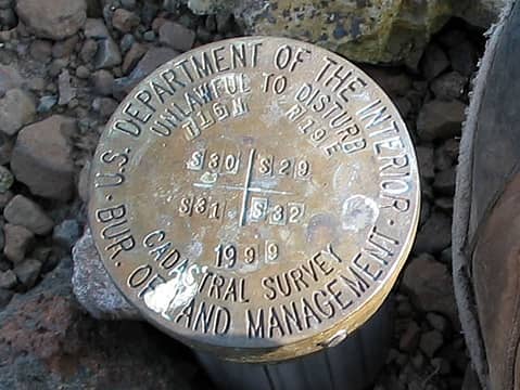
I think we missed each other because I wasn't sure which trail to take. At the grove of aspen trees, I took a left instead of a right, cutting back towards the river to get on top of an arm that gradually made its way up to the top. I wasn't sure if the faint trail I was following was created by deer or people. Probably both, as there were many piles of "Whoppers," and about half-way up, I came across a USGS marker out in the middle of nowhere.
Can someone tell me whether those markers reveal any information a hiker can use? I come across them every once in a while, but the numbers and letters don't make sense. I attached a closeup photo of the marker I saw on Saturday. I use the TOPO (USGS?) maps for Washington - are the marker locations represented on the map?
Thanks!
 usgs
|
| Back to top |
|
|
jimmymac
Zip Lock Bagger
Joined: 14 Nov 2003
Posts: 3705 | TRs | Pics
Location: Lake Wittenmyer, WA |
|
jimmymac
Zip Lock Bagger
|
Tue Apr 27, 2004 8:14 pm |
|
|
I'd take it as the corner monument for the four sections represented at the bottom (Section 29, 30, 31, & 32) within the intersection of two 6-mile swaths of land. Township 15 North is the E-W swath of land. Range 19 East is the N-S swath of land. You could pinpoint your location on a map that has Ordinance coordinates. Stamped aluminum plates are sometimes nailed to trees with similar info. 19th century GPS.
"Profound serenity is the product of unfaltering Trust and heightened vulnerability."
"Profound serenity is the product of unfaltering Trust and heightened vulnerability."
|
| Back to top |
|
|
John
Member
Joined: 28 May 2003
Posts: 143 | TRs | Pics
Location: Edmonds |
|
John
Member
|
Tue Apr 27, 2004 8:29 pm |
|
|
Thanks for the info, Jimmy! That's pretty cool! I never noticed. That marker is right at the intersection of section 29, 30, 31 and 32!
Wow. I wouldn't believe you if you told me there's a marker at EVERY intersection... Is there?
Also, the 1999 on the marker probably isn't the elevation, is it? On the map, it looks like it's closer to 2350'.
|
| Back to top |
|
|
jimmymac
Zip Lock Bagger
Joined: 14 Nov 2003
Posts: 3705 | TRs | Pics
Location: Lake Wittenmyer, WA |
|
jimmymac
Zip Lock Bagger
|
Tue Apr 27, 2004 9:01 pm |
|
|
They're few and far between in my experience, but over there, why not? With no trees you could survey the whole basin like you were striping parking stalls at Fred Meyer.
More often, you'll find an embossed metal panel, showing a 6X6 matrix. If the plate is nailed to a tree, which is located in the SW corner of the NE quarter of Section 22, Township Y N, Range X E, then a nail hole is poked into the approximate center of the box labeled 22 on the plate. The township and range designations are scratched into blank spaces at the top of the plate.
I find these installations intriguing, not so much because of the information they bear, but because they're typically festooned with tons of flagging tape.
"Profound serenity is the product of unfaltering Trust and heightened vulnerability."
"Profound serenity is the product of unfaltering Trust and heightened vulnerability."
|
| Back to top |
|
|
|
|


