| Previous :: Next Topic |
| Author |
Message |
Yana
Hater


Joined: 04 Jun 2004
Posts: 4212 | TRs | Pics
Location: Out Hating |
|
Yana
Hater
|
 Fri Mar 19, 2010 10:07 pm |
|
|
After an unsuccessful but instructive attempt on Quartz Mountain in December, dicey and I were ready to head back, this time armed with ErinB and more first hand route knowledge.
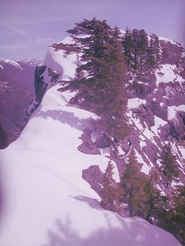
We were both drawn to the route described in Carl Dreisbach's Middle Fork Guide, mainly because it goes up a long, interesting looking gully, This is visible through the trees from the Middle Fork Road. Here's a photo from the route:
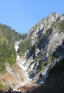 Quartz gully to Yin Yang Pass  This time, we made much better time on this most efficient route. The route description in the book references a no longer drivable road and does not mention the CCC Trail, which is the best approach. The trick is knowing where to turn off the trail (at least it's tricky without a GPS) - there are a number of wrong rocky streambeds you could follow up, but if you turn off too soon, you will end up going up the wrong drainage.
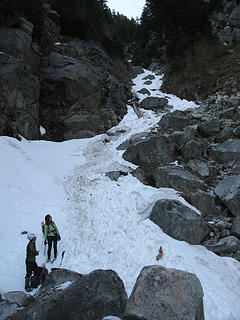
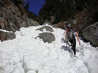
Shortly after reaching this rock referenced in the route description, forest gives way to tall, thick brush mixed in with sharp spiky unpleasantness.
This time, we made much better time on this most efficient route. The route description in the book references a no longer drivable road and does not mention the CCC Trail, which is the best approach. The trick is knowing where to turn off the trail (at least it's tricky without a GPS) - there are a number of wrong rocky streambeds you could follow up, but if you turn off too soon, you will end up going up the wrong drainage.
Shortly after reaching this rock referenced in the route description, forest gives way to tall, thick brush mixed in with sharp spiky unpleasantness.
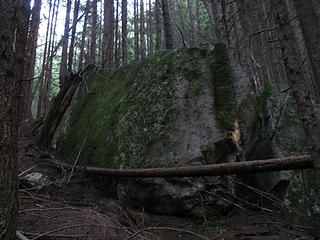 Big Rock mentioned in Middle Fork Guide route description 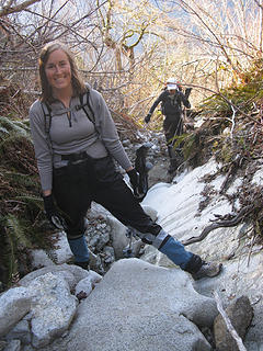 Brush avoidance tactics 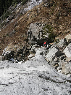 Scrambing the snowless lower gully 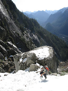 Carla ascends above ginormous boulder 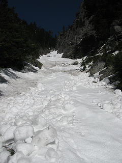 Looking up the gully 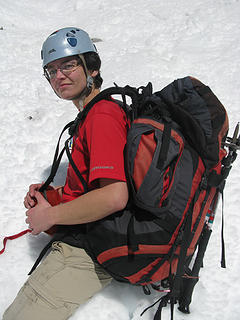 Missing a leg 
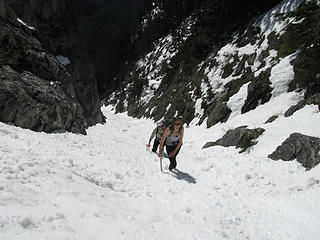 Gully fun 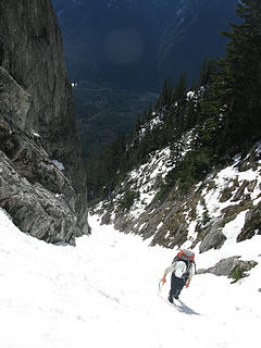 Up the gully! 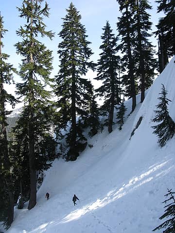 Dropping down from Yin Yang Pass 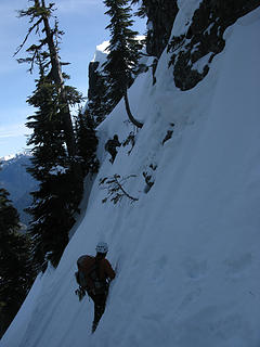 Steep traversing 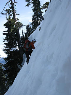 More steep traversing 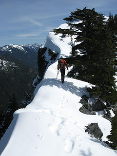 On the crest 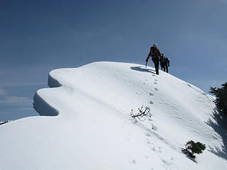 Interesting ridge walking 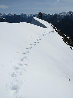 Arriving at the summit 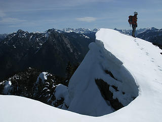 Carla on Quartz #1 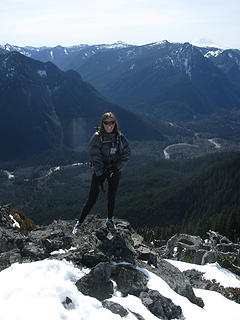 Erin on Quartz #1 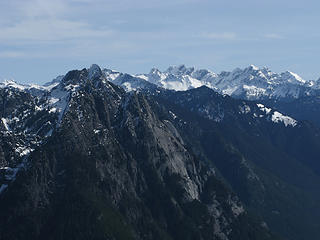 Garfield and some other stuff  Following the narrow crest 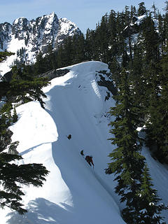 Descending from Quartz ridge, Bessemer behind 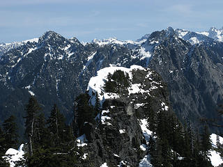 Quartz #1 with our tracks on it 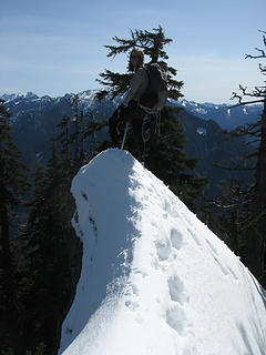 Erin on Quartz #2 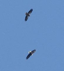 Eagles! 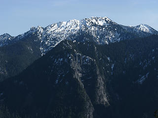 Preacher 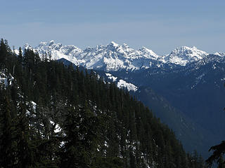 Lemah and stuff 
 Carla and Erin admire the gully  This is an amazingly alpine-y trip for a peak that's under 5000'! I love the Middle Fork!
About 7 miles RT and 5200' gain.
Approximate route: http://www.gmap-pedometer.com/?r=3557793
This is an amazingly alpine-y trip for a peak that's under 5000'! I love the Middle Fork!
About 7 miles RT and 5200' gain.
Approximate route: http://www.gmap-pedometer.com/?r=3557793
PLAY SAFE! SKI ONLY IN CLOCKWISE DIRECTION! LET'S ALL HAVE FUN TOGETHER!
PLAY SAFE! SKI ONLY IN CLOCKWISE DIRECTION! LET'S ALL HAVE FUN TOGETHER!
|
| Back to top |
  
|
|
EastKing
Surfing and Hiking

Joined: 28 Mar 2007
Posts: 2082 | TRs | Pics
Location: 77 miles from Seattle! |
|
EastKing
Surfing and Hiking
|
Fri Mar 19, 2010 10:11 pm |
|
|
Nice work and what a great find!!!!
YouTube | SummitPost
Saw the depths of despair. Now I am salvaging what time I have left on Earth.
YouTube | SummitPost
Saw the depths of despair. Now I am salvaging what time I have left on Earth.
|
| Back to top |
|
|
Matt
Tea, Earl Grey, Hot

Joined: 30 Jan 2007
Posts: 4307 | TRs | Pics
Location: Shoreline |
|
Matt
Tea, Earl Grey, Hot
|
Fri Mar 19, 2010 10:43 pm |
|
|
Yana had bare legs and ErinB didn't. What's the world coming to?
As beacons mountains burned at evening. J.R.R. Tolkien
As beacons mountains burned at evening. J.R.R. Tolkien
|
| Back to top |
|
|
Type E
Member

Joined: 19 Aug 2006
Posts: 1381 | TRs | Pics
|
|
Type E
Member
|
Fri Mar 19, 2010 11:21 pm |
|
|
Any thoughts on your route compared to coming up from the Quartz Creek side?
|
| Back to top |
|
|
puzzlr
Mid Fork Rocks

Joined: 13 Feb 2007
Posts: 7220 | TRs | Pics
Location: Stuck in the middle |
|
puzzlr
Mid Fork Rocks
|
Fri Mar 19, 2010 11:25 pm |
|
|
Middle Fork Feats! 
|
| Back to top |
|
|
BirdDog
Member
Joined: 09 Jan 2007
Posts: 1067 | TRs | Pics
Location: Seattle |
|
BirdDog
Member
|
Sat Mar 20, 2010 6:32 am |
|
|
Very nice! Love the corniced ridge shot.
"There can be no greater issue than that of conservation in this country."
Teddy Roosevelt August 6, 1912
"There can be no greater issue than that of conservation in this country."
Teddy Roosevelt August 6, 1912
|
| Back to top |
|
|
bonobo
Owl Juggler for rent
Joined: 23 Jun 2004
Posts: 818 | TRs | Pics
|
|
bonobo
Owl Juggler for rent
|
Sat Mar 20, 2010 7:52 am |
|
|
Glad you had success this time! Those ridge walking pics are wonderful.
|
| Back to top |
|
|
Bernardo
Member

Joined: 08 Feb 2010
Posts: 2174 | TRs | Pics
Location: out and about in the world |
|
Bernardo
Member
|
Sat Mar 20, 2010 8:20 pm |
|
|
Nice trip report. I will definitely add this to my MF list. I liked the picture with the Pratt River Valley in the background.
|
| Back to top |
|
|
ErinB
Member

Joined: 23 Jun 2006
Posts: 34 | TRs | Pics
|
|
ErinB
Member
|
Sat Mar 20, 2010 9:01 pm |
|
|
Yea for WA!!! So good to be back and into the mountains right away - thanks for the invite Dicey and Yana!
Very nice pics, Yana - especially catching two of the eagles! Too bad they didn't listen to Dicey's requests to come closer!
Wish I had pictures to contribute, but all mine turned out looking like this:
 Quartz summit  lined gully
|
| Back to top |
|
|
Yana
Hater
Joined: 04 Jun 2004
Posts: 4212 | TRs | Pics
Location: Out Hating |
|
Yana
Hater
|
Sat Mar 20, 2010 9:44 pm |
|
|
Matt - the bare legs resulted from a fit of insanity brought on by warm sun amidst warm rocks. Somehow, the insanity continued and I never put the pantlegs back on despite multiple reasons to do so. Consequently, my knees are now scrached up and red from thorny annoyances. Oh well, at least there was no devil's club!
Type E - I can't really compare since I have no knowledge of the Quartz Creek approach, but this route is very direct, aesthetic, and pretty quick. I'm not sure how pleasant or unpleasant the gully is when completely melted out later in the season - the lower melted out sections were fairly simple, unexposed scrambling with a couple of steps mixed in for good measure. Hope that helps!
Edited to add: here's a quote from the midfork.org website, a great resource, but sadly now defunct and only accessible via the wayback machine.  :
"It's possible to do this climb from the north side, via the Quartz Creek road, but even if you hit it optimally it's a pretty brushy mountainside. If you take the wrong line you are going to thrash a lot of brush. So Carl's gully route is probably best, although a little more demanding from the scrambling point of view. "
Erin - nice pictures. I feel so... pink. :
"It's possible to do this climb from the north side, via the Quartz Creek road, but even if you hit it optimally it's a pretty brushy mountainside. If you take the wrong line you are going to thrash a lot of brush. So Carl's gully route is probably best, although a little more demanding from the scrambling point of view. "
Erin - nice pictures. I feel so... pink.
PLAY SAFE! SKI ONLY IN CLOCKWISE DIRECTION! LET'S ALL HAVE FUN TOGETHER!
PLAY SAFE! SKI ONLY IN CLOCKWISE DIRECTION! LET'S ALL HAVE FUN TOGETHER!
|
| Back to top |
|
|
gabrielx
Member

Joined: 15 Nov 2004
Posts: 72 | TRs | Pics
|
|
gabrielx
Member
|
Mon Mar 22, 2010 10:48 pm |
|
|
| Yana wrote: | | We decided we weren't quite finished and went on to pt. 4487, nicknamed by gabrielx (I think) Bessequartz because of its location. |
It wasn't named by me, it was named by Douglas McCarville and Joe. Their TR is on the midforc.org website, which seems to be dead so here is a link to the TR via the Way Back Machine: http://web.archive.org/web/20030502233610/www.midfork.org/fram?url_id=30
Nice job on climbing both!
|
| Back to top |
|
|
dicey
custom title

Joined: 11 May 2004
Posts: 2870 | TRs | Pics
Location: giving cornices a wider berth |
|
dicey
custom title
|
Tue Mar 23, 2010 1:43 pm |
|
|
Yikes!
Thanks Gabriel, that sounds terrible  The difficulty of Quartz is getting to the gully without too much alder thrashing, and then finding the true summit amongst the imposters!
 ballz! 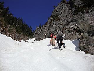 getting higher 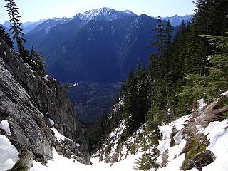 another view down 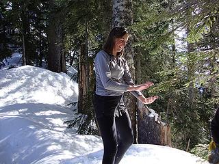 Erin doing some tai chi at yin yang pass 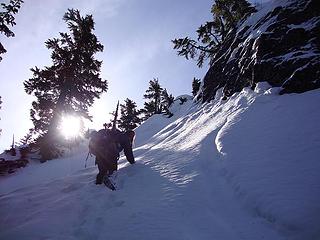 regaining the ridge to Quartz 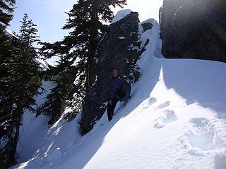 It is hard to stay on this ridge! 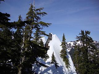 also not the summit of Quartz mtn 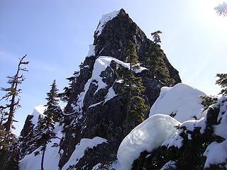 another non-Quartz summit with true summit visible to left 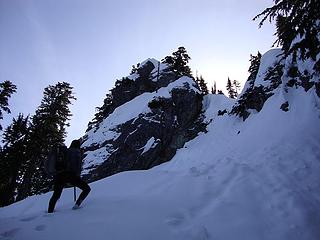 this is not the summit of Quartz mtn 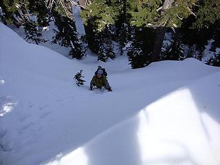 Yana climbing to the ridge 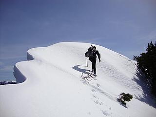 summit ahoy 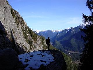 a commanding perch
|
| Back to top |
|
|
|
|


