| Previous :: Next Topic |
| Author |
Message |
Ice Girl
Member


Joined: 30 Apr 2002
Posts: 291 | TRs | Pics
|
|
Ice Girl
Member
|
 Wed Jun 12, 2002 5:59 pm |
|
|
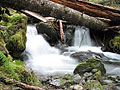
 Drove up FSR 41, 7.5 miles and 1900ft gain from Mtn Loop Hwy. Then, this...
I believe this warsh out is right on the bend at the South Fork in the rd., i don't think it is at the creek before it. But there is a creek right before the wash out, too. i can't say i know this rd. very well only been on it two times.
Then drove back down the rd. to the FSR 4111, followed it to the 4110 rd. and followed it for a total of 5 miles and 2950 ft. gain, until the snow once again covered the rd.
anyone wanting to see pic can email me and i will send them to you.
Drove up FSR 41, 7.5 miles and 1900ft gain from Mtn Loop Hwy. Then, this...
I believe this warsh out is right on the bend at the South Fork in the rd., i don't think it is at the creek before it. But there is a creek right before the wash out, too. i can't say i know this rd. very well only been on it two times.
Then drove back down the rd. to the FSR 4111, followed it to the 4110 rd. and followed it for a total of 5 miles and 2950 ft. gain, until the snow once again covered the rd.
anyone wanting to see pic can email me and i will send them to you.
|
| Back to top |
  
|
|
Ice Girl
Member
Joined: 30 Apr 2002
Posts: 291 | TRs | Pics
|
|
Ice Girl
Member
|
Wed Jun 12, 2002 6:03 pm |
|
|
Whooo...
i am impressed, i actually finally got some pick on the site, and they look good. Hey, and i didn't even crash the sight this time..
Ice Girl
|
| Back to top |
|
|
lopper
off-route

Joined: 22 Jan 2002
Posts: 845 | TRs | Pics
|
|
lopper
off-route
|
Wed Jun 12, 2002 7:35 pm |
|
|
All Hail Ice Girl.
Thanks for the photo-jounalist heroics on the thrashed-road story!
Info like this and Randy's log-o-rama make this computer nonsense almost worthwhile.
|
| Back to top |
|
|
Scrooge
Famous Grouse

Joined: 16 Dec 2001
Posts: 6966 | TRs | Pics
Location: wishful thinking |
|
Scrooge
Famous Grouse
|
Wed Jun 12, 2002 8:04 pm FS 41
|
|
|
Great reporting job, Ice Girl.  Looks like it's gonna be a looonnnng time before we drive to Tupso Pass again. Looks like it's gonna be a looonnnng time before we drive to Tupso Pass again.  BPJ, that may take more than 44" tires. A caterpiller tractor would get stuck in the bottom of that ravine.
IG, we need to see the real photo #6.
Tom, can we "edit" posted pics and links?
BPJ, that may take more than 44" tires. A caterpiller tractor would get stuck in the bottom of that ravine.
IG, we need to see the real photo #6.
Tom, can we "edit" posted pics and links?
Something lost behind the ranges. Lost and waiting for you....... Go and find it. Go!
Something lost behind the ranges. Lost and waiting for you....... Go and find it. Go!
|
| Back to top |
|
|
Roxann
Member
Joined: 25 Feb 2002
Posts: 29 | TRs | Pics
|
|
Roxann
Member
|
Wed Jun 12, 2002 8:10 pm |
|
|
So you went by yourself. I am sooooo jealous. Being stuck at work on a day like today. But I did enjoy the photos.
|
| Back to top |
|
|
Sundance Kid
Hiking the Wasatch

Joined: 07 Jun 2002
Posts: 120 | TRs | Pics
Location: Orem, Utah |
|
Sundance Kid
Hiking the Wasatch
|
Wed Jun 12, 2002 9:27 pm Other way in?
|
|
|
Can't you drive up to Tupso Pass from the other side? Coming in from the Lake Riley Road out by Arlington, up Jim Creek? It looks like FR 4150 will take you up there...unless, of course, there are GATES!
Just where is it I can find beaver, bear, and other critters that are worth cash money when skint?
Just where is it I can find beaver, bear, and other critters that are worth cash money when skint?
|
| Back to top |
|
|
Ice Girl
Member
Joined: 30 Apr 2002
Posts: 291 | TRs | Pics
|
|
Ice Girl
Member
|
Wed Jun 12, 2002 9:33 pm |
|
|
There seems to be a rd. on the map, but i didn't have time to do that. i did try to get to the rd. above it and see if the wash out was up that high, too. But the rd. had snow covering it at 5 miles.
Ice Girl
|
| Back to top |
|
|
Tom
Admin
Joined: 15 Dec 2001
Posts: 17851 | TRs | Pics
|
|
Tom
Admin
|
Wed Jun 12, 2002 9:44 pm |
|
|
| Scrooge wrote: | | Tom, can we "edit" posted pics and links? |
Yes, you can edit/add/delete attachments by editing your post.
|
| Back to top |
|
|
rubberlegs
Guest
|
|
rubberlegs
Guest
|
Wed Jun 12, 2002 10:24 pm New assignment - Squire Creek slide
|
|
|
Hey Ice Girl, can you go up Squire Creek road and document that slide? I've been told by several sources that it's extremely impressive -- several hundred feet wide coming from the top of the mountain. Wonder if it is closing down places like Three O'clock Rock, Exfoliation Dome, Green Giant Buttress, Squire Creek trail... etc.
|
| Back to top |

|
|
Ice Girl
Member
Joined: 30 Apr 2002
Posts: 291 | TRs | Pics
|
|
Ice Girl
Member
|
Thu Jun 13, 2002 7:43 am |
|
|
Right, rubberlegs... i went up to three fingers because last year i hiked almost all the way to goat flats and this year i was interested in backpacking in there for a night. But who knows maybe i will just go and do it. i am not sure exactly where this place is? Could you give me an idea where it is?

|
| Back to top |
|
|
REJ
Member
Joined: 21 Mar 2002
Posts: 100 | TRs | Pics
|
|
REJ
Member
|
Thu Jun 13, 2002 8:19 am |
|
|
Rubberlegs: The landslide your are referring to I believe is on the Squire Creek Road. (The FS had an aerial view of the big landslide on their website which is now gone). Access to Darrington Rock (3 o'clock, etc) is from the Clear Creek Road which is on the other side of Jumbo Mtn. Since the landslide on the Squire Creek Road I expect that the Eight Mile Creek trail from Clear Creek Road becomes the preferred trail to Squire Creek Pass.
|
| Back to top |
|
|
McPilchuck
Wild Bagger
Joined: 17 Dec 2001
Posts: 856 | TRs | Pics
Location: near Snohomish, Wa. |
This just in, came to me in a personal email:
Ken J. (McPilchuck)
Forest Service Rd. #41 will be closed until approximately August at the 7.5
mile. More information about repair and reopening should be known by the beginning-middle of July.
Thank you,
Jodi
|
| Back to top |
|
|
Backpacker Joe
Blind Hiker

Joined: 16 Dec 2001
Posts: 23956 | TRs | Pics
Location: Cle Elum |
"If destruction be our lot we must ourselves be its author and finisher. As a nation of freemen we must live through all time or die by suicide."
Abraham Lincoln
|
| Back to top |
|
|
|
|


