| Previous :: Next Topic |
| Author |
Message |
ldyblade
Member


Joined: 26 Feb 2003
Posts: 108 | TRs | Pics
Location: Joyce, WA |
|
ldyblade
Member
|
 Sat Jan 29, 2011 10:10 pm |
|
|
Note: There is a washout/slide on the road 1 mile from the Royal Basin TH. When we went today, we got out of the truck to inspect the damage before determining that (at the moment) it was safe. The creek has dumped more than it has taken away, but the cliff side of the road looks a little crumbly. This may pose a problem for any lower clearance vehicles and probably impossible for stock trailers.
Other than that, Rumidude and I enjoyed our quick ramble up to the bridge and back. We had arrived at the TH about 3pm, so that was about all the sunlight would allow. There is a trio of trees down about a quarter mile in. Easy enough for a hiker to get around, a wee bit harder for bike or horse.
|
| Back to top |
  
|
|
onemoremile
Member

Joined: 26 Dec 2010
Posts: 1305 | TRs | Pics
Location: Sequim |
Thanks for posting this. I was wondering where to post basically the same thing. I cleared a lot of rocks off of FS 2870 a few days ago....but that slide was a bit much! There was also a large washout on the lower trail about half a mile up from River Camp, and a large tree down about 2 miles past Camp Handy. I'll see if my shovel wants to play with the slide....that's not going to be a fun one with a bunch of snow on top!
Arbolist? Look up the word. I dont know, maybe I made it up. Anyway, its an arbo-tree-ist, somebody who knows about trees. G.W. Bush
Arbolist? Look up the word. I dont know, maybe I made it up. Anyway, its an arbo-tree-ist, somebody who knows about trees. G.W. Bush
|
| Back to top |
|
|
Slugman
Its a Slugfest!

Joined: 27 Mar 2003
Posts: 16874 | TRs | Pics
|
|
Slugman
Its a Slugfest!
|
Sun Jan 30, 2011 12:04 am |
|
|
So, what kind of snow conditions exist up there right now? Is there any? I'm thinking of taking the wonder dog on a little jaunt with the great weather forecast for the next few days.
|
| Back to top |
|
|
ldyblade
Member
Joined: 26 Feb 2003
Posts: 108 | TRs | Pics
Location: Joyce, WA |
|
ldyblade
Member
|
Sun Jan 30, 2011 12:10 am |
|
|
Nothing but a little ice left in the parking lot. Didn't see anything at all on the trail. Supposed to snow a little tonight, but not much accumulation, per NOAA.
|
| Back to top |
|
|
Slugman
Its a Slugfest!

Joined: 27 Mar 2003
Posts: 16874 | TRs | Pics
|
|
Slugman
Its a Slugfest!
|
Sun Jan 30, 2011 12:18 am |
|
|
Whoohoo, thanks! Looks like a nice early backpacking trip is in order. Or we could dayhike to camp Handy Monday, then do the Gray Wolf Tuesday, and have the "luxury" of sleeping in the car.
|
| Back to top |
|
|
ldyblade
Member
Joined: 26 Feb 2003
Posts: 108 | TRs | Pics
Location: Joyce, WA |
|
ldyblade
Member
|
Sun Jan 30, 2011 9:08 am |
|
|
Why not do both?  Hike up to the Bridge and set up camp. Run up to Camp Handy and back and spend the night listening to the river. Easy mile back out, drive to Gray Wolf and day hike. Hike up to the Bridge and set up camp. Run up to Camp Handy and back and spend the night listening to the river. Easy mile back out, drive to Gray Wolf and day hike.  I tell ya, I was wishing I had the tent and bag yesterday. I tell ya, I was wishing I had the tent and bag yesterday.
|
| Back to top |
|
|
RodF
Member

Joined: 01 Sep 2007
Posts: 2593 | TRs | Pics
Location: Sequim WA |
|
RodF
Member
|
Thu Feb 10, 2011 5:32 pm |
|
|
Photos of the debris flow on FS2870, 1 mile below the Upper Dungeness/Royal Creek trailhead parking area.
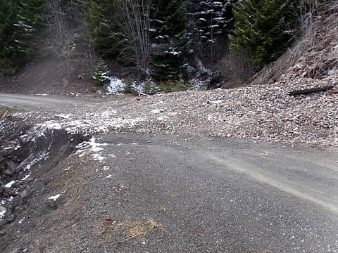 FS2870 road, 1 mi N upper Dungeness 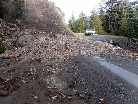 same, looking north
"of all the paths you take in life, make sure a few of them are dirt" - John Muir
"the wild is not the opposite of cultivated. It is the opposite of the captivated - Vandana Shiva
"of all the paths you take in life, make sure a few of them are dirt" - John Muir
"the wild is not the opposite of cultivated. It is the opposite of the captivated - Vandana Shiva
|
| Back to top |
|
|
oldwhiner
Member

Joined: 17 Jun 2007
Posts: 279 | TRs | Pics
Location: when not on a trail - S. Puget Sound |
Is that gravel pile loose? With my luck the gravel would start sliding when I got on it and I be inventing a new extreme sport.
Dreaming - a wistful dilemma between hope and disappointment, perpetuated by occasional bouts of happiness.
Dreaming - a wistful dilemma between hope and disappointment, perpetuated by occasional bouts of happiness.
|
| Back to top |
|
|
silence
Member

Joined: 25 Apr 2005
Posts: 4420 | TRs | Pics
|
|
silence
Member
|
Fri Feb 11, 2011 9:07 pm |
|
|
thx for posting rod .. is there a chance the fs will close this? heard any talk? that would suck ...
PHOTOS
FILMS
Keep a good head and always carry a light bulb. Bob Dylan
PHOTOS
FILMS
Keep a good head and always carry a light bulb. Bob Dylan
|
| Back to top |
|
|
onemoremile
Member
Joined: 26 Dec 2010
Posts: 1305 | TRs | Pics
Location: Sequim |
The rocks are about the size of tennis balls, with some up to basketball size. There is dirt packed in too. A large part of the road has fallen off and is undercut about a foot. The water is washing it out on one side, but it is still plenty sturdy to drive across. I'll check it out again tomorrow. Honestly, though, the potholes on other parts of the road are bigger car-eaters.
Arbolist? Look up the word. I dont know, maybe I made it up. Anyway, its an arbo-tree-ist, somebody who knows about trees. G.W. Bush
Arbolist? Look up the word. I dont know, maybe I made it up. Anyway, its an arbo-tree-ist, somebody who knows about trees. G.W. Bush
|
| Back to top |
|
|
RodF
Member
Joined: 01 Sep 2007
Posts: 2593 | TRs | Pics
Location: Sequim WA |
|
RodF
Member
|
Mon Feb 14, 2011 2:11 pm |
|
|
| silence wrote: | | thx for posting rod .. is there a chance the fs will close this? heard any talk? that would suck ... |
Naah, no safety hazard. Tracks show that most vehicles that've gone up there have chosen to cross it, and those that don't have plenty of sight-line to see it, and space to park or turn around. It's been there for 2 months.
Road bed itself is buried but undamaged, and nearby streambed and culvert are not affected at all, so it won't take more than a half-hour with a front-end loader to clear it.
Last year, a worse slide/washout 3 miles further up this road didn't close it. photo
It's not a big deal, I just posted it so hikers who might drive to the trailheads would be aware. ONF usually doesn't blade this road until late May, but is aware of this - I'll post if they clear it sooner.
(psst... Don't give our local anti-access advocates ideas, Silence! )
"of all the paths you take in life, make sure a few of them are dirt" - John Muir
"the wild is not the opposite of cultivated. It is the opposite of the captivated - Vandana Shiva
"of all the paths you take in life, make sure a few of them are dirt" - John Muir
"the wild is not the opposite of cultivated. It is the opposite of the captivated - Vandana Shiva
|
| Back to top |
|
|
|
|


