| Previous :: Next Topic |
| Author |
Message |
Elvis
Shuffl'n


Joined: 09 Jun 2004
Posts: 1804 | TRs | Pics
Location: del Boca Vista |
|
Elvis
Shuffl'n
|
 Mon Apr 18, 2011 11:05 pm |
|
|
After my warm up hike (with snow) on nearby Devil Mountain, it seemed like a fine opportunity to do a little exploring on the west side of the ridge.
According to my Topo Map, there is a lake near Devil Mountain called Ten Lake. Near Ten Lake is a high point that is labeled "Scott Mountain". On the western side of Scott Mountain, Topo shows a road that ends at a "Mine".
This was my desired location.
I found a well paved road with large undeveloped residential lots weaving up the mountainside and this road interesected the road showing on Topo. It intersected... but didn't follow the route.
At the intersection (look for Lot #8, across the street from Lot #19) is a gravel road heading up the hillside. Viola! So I thought.
I parked and started following the road uphill. There was a sign saying you need the owners permission for hunting.
The road wasn't really going in the direction that Topo said it was supposed to go. Since there didn't seem to be any other viable option (and I had nothing better to do), I continued upward.
Eventually, a water tower is reached. There is another road descending from the water tower which goes back to the paved road at the paved road's dead-end/cul de sac. You should consider just parking at the end of the paved road (it will save you a bit of elevation gain and has a better parking spot). All the lots up here are leveled but not built upon, yet.
Also at the water tower was a less noticable road that continued ascending and it appeared to be turning in the proper direction, so I continued upward.
A short while later, the ground levels out and you find yourself at an actual intersection of roads... and closer to the Topo implied route. You also find yourself next to a large house at another residential community's paved dead-end road. You CAN drive to the end of the pavement, but I'm not sure if it's a private road or whether or not you can park there. Doing so would save you quite a bit of elevation gain and could potentailly really shorten the trip.
Also at this intersection is a cliffy/ridgy sort of protusion. The map is telling me the mine is above this ridge/protusion, but a couple hundered feet up. Looks like a lot of bushwacking.
OR...
The map also indicates that if I head south, I will intersect the Topo road, which would/should then provide an easy and direct route directly to the mine - but it's a long switchback. Is it worth it to do the road or would it be better to bushwack and climb?
I chose the road route, since I was solo and new to the area, and don't have a lot of experience off trail.
The road was easy to follow but definitely getting overgrown. Doing this in summer is going to involve lots of alders, devils club, nettles and blackberries.
When I finally intersected the Topo road, there was another branch heading downhill which is where I was supposed to be coming up from. So, it probably does lead down to near Lot #8, but I think it's a boggy, swampy mess to access it. Just my theory (I tried to find it on my return but was not successful).
So, I followed the topo directed route upward to the 180 degree switchback turn. There was a third road at this intersection, but it went the wrong direction (S instead of N).
The upper segment of the switchback took me to an elevation that was above the mine, but the road dead-ended on the spine of the ridge... where the mine was supposed to be, but slightly higher in elevation.
Maybe I was at the mine and the map is wrong, or maybe the mine was down over the edge where I couldn't see it. Don't know anything about the mine... if it was a shaft or if it was just an open pit. No idea what to look for.
So, I headed back, with a couple side trips to explore game trails in hopes of finding another route to a lower elevation. No dice.
Eventually, I ended up back at the big house, looking at the ridge protusion.
Decided to explore the protrusion area and walked through deep sucking mud to follow what could have been trails or something. Eventually worked my way upwards into dense vegitation to just below the mine symbol.
No evidence of anything around there, but I didn't really go up quite as high as the topo said I should. Just too much out of my comfort zone.
Will have to do a little research on the mine and maybe head back some day with a buddy.
My route (and exploring) included 2.9 miles and 954 feet of elevation gain. One way (the long way, on the topo road and around the water tower) is about 1.18 miles and 735 feet of gain. If you park at the other residential community, it's probably less than a half mile of bushwacking upwards.
Drop me a PM if you're interested.
Thursday morning is wide open.  Here are a few pics. More will be on my blog, eventually.
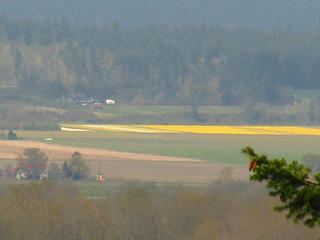 That Time Of Year 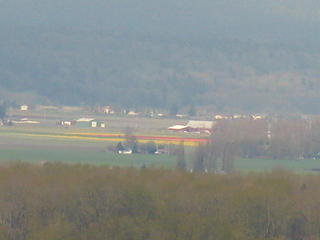 Two Lips 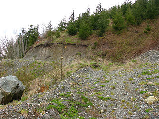 1 label Gravel Pitt... or maybe the mine? 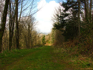 Old Road (on map) 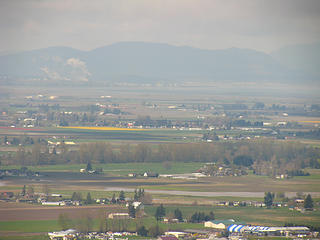 Skagit Daffy's 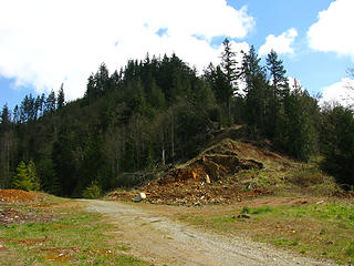 6 labels Scott Mtn and a mine (somewhere)
"Ill habits gather unseen degrees, as brooks make rivers, rivers run to seas." ~John Dryden
My Trip List
"Ill habits gather unseen degrees, as brooks make rivers, rivers run to seas." ~John Dryden
My Trip List
|
| Back to top |
  
|
|
Jimbo
Member

Joined: 14 Feb 2005
Posts: 1558 | TRs | Pics
Location: Arlington |
|
Jimbo
Member
|
Tue Apr 19, 2011 4:52 am |
|
|
Guns only have two enemies; rust and politicians
|
| Back to top |
|
|
Jimbo
Member
Joined: 14 Feb 2005
Posts: 1558 | TRs | Pics
Location: Arlington |
|
Jimbo
Member
|
Tue Apr 19, 2011 5:31 am |
|
|
I have pics on the NWUE site on yahoo group. 2nd page down left side I think....
Guns only have two enemies; rust and politicians
Guns only have two enemies; rust and politicians
|
| Back to top |
|
|
Redwic
Unlisted Free Agent

Joined: 23 Feb 2009
Posts: 3292 | TRs | Pics
Location: Going to the Prom(inence) |
|
Redwic
Unlisted Free Agent
|
Tue Apr 19, 2011 5:31 am |
|
|
I was looking forward to seeing photos of a mine!
It is probably overgrown and possibly collapsed.
60 pounds lighter but not 60 points brighter.
60 pounds lighter but not 60 points brighter.
|
| Back to top |
|
|
Jimbo
Member
Joined: 14 Feb 2005
Posts: 1558 | TRs | Pics
Location: Arlington |
|
Jimbo
Member
|
Tue Apr 19, 2011 6:13 am |
|
|
Not this one, solid rock. I have pics in Flicker but I don't pay for that so there deep in the arcives...
Guns only have two enemies; rust and politicians
Guns only have two enemies; rust and politicians
|
| Back to top |
|
|
Elvis
Shuffl'n

Joined: 09 Jun 2004
Posts: 1804 | TRs | Pics
Location: del Boca Vista |
|
Elvis
Shuffl'n
|
Tue Apr 19, 2011 10:04 pm |
|
|
Thanks for the insights jimbo. I'll do some more research on it later this week to see if I can sort it out (and figure out if I need to go back or not). 
"Ill habits gather unseen degrees, as brooks make rivers, rivers run to seas." ~John Dryden
My Trip List
"Ill habits gather unseen degrees, as brooks make rivers, rivers run to seas." ~John Dryden
My Trip List
|
| Back to top |
|
|
Jimbo
Member
Joined: 14 Feb 2005
Posts: 1558 | TRs | Pics
Location: Arlington |
|
Jimbo
Member
|
Wed Apr 20, 2011 6:37 am |
|
|
Guns only have two enemies; rust and politicians
|
| Back to top |
|
|
Boondog
Member

Joined: 31 Jul 2010
Posts: 15 | TRs | Pics
Location: Gold Bar, WA |
|
Boondog
Member
|
Sun Apr 24, 2011 8:43 am |
|
|
Devils lake is full of large beautiful eastern brookies! The best fishing is in spring during a mayfly hatch. Used to fish off the log jam in the NW inlet with spinning gear as the bottom is full of snags. The large kitties in the area are more of a concern than the locals...
|
| Back to top |
|
|
Jimbo
Member
Joined: 14 Feb 2005
Posts: 1558 | TRs | Pics
Location: Arlington |
|
Jimbo
Member
|
Wed Apr 27, 2011 5:23 am |
|
|
Kitties, Great..... I love Brookies, and they love Zug Bugs, thanks for the info..
Guns only have two enemies; rust and politicians
Guns only have two enemies; rust and politicians
|
| Back to top |
|
|
|
|
You cannot post new topics in this forum
You cannot reply to topics in this forum
You cannot edit your posts in this forum
You cannot delete your posts in this forum
You cannot vote in polls in this forum
|
Disclosure: As an Amazon Associate NWHikers.net earns from qualifying purchases when you use our link(s). |


 We always wanted to find that Devils lake fish it as we heard stories of HUGE Cuts... But gated we were not walking and heard of crazy people with guns that would chase your butt off if they seen you there
  In DWHM Vol 1 there is a small section that talks about a nickle mine on that West side of the hill facing I-5.. I looked at my topo mine program, made some print outs and off I went a few years back...
There are suppose to be more than 1 mine up there. 4-5 that I know of.
I spent some time driving around, found the area to be developed that had a dirt road running up the hill but to the South of the tower. I then found a small privet drive that led to a Bed and Breakfast Hmmm. I said what the heck I'll se were it ends up.
It was a nice place looking West and an older couple did have a bed and breakfast there. After telling the older Gent I was looking for a mine and showed my info with maps and Vol 1 he opened up some info for me.
That area soon to be homes was his land, told me of old rail lines that ran the hill side North and South and things to look for. He gave me some incite on this nickel mine and another. To the North below the tower there was a new road punched in and it went right over the top of a large tunnel that went in a few hundred feet. He and his buddy were going to blow it open at some point but never did get back with me on that ?????? I should go see this area again I guess..
There is a small tunnel he said that is right in a back yard or just off a fence. Gave me some directions to find this house and said if I asked they would probly let me have a look. I found the house but no one home. Now looking at land marks and were I was in that newly cleared area I went back, found a small rail line. I'm talking no wide at all.. Lot's of bush chopping and sweating I found it. There was now people in the back yard.l wasn't going to turn with out seeing this mine. It was about 100 feet away, I was in cammo and did the low crawl
In DWHM Vol 1 there is a small section that talks about a nickle mine on that West side of the hill facing I-5.. I looked at my topo mine program, made some print outs and off I went a few years back...
There are suppose to be more than 1 mine up there. 4-5 that I know of.
I spent some time driving around, found the area to be developed that had a dirt road running up the hill but to the South of the tower. I then found a small privet drive that led to a Bed and Breakfast Hmmm. I said what the heck I'll se were it ends up.
It was a nice place looking West and an older couple did have a bed and breakfast there. After telling the older Gent I was looking for a mine and showed my info with maps and Vol 1 he opened up some info for me.
That area soon to be homes was his land, told me of old rail lines that ran the hill side North and South and things to look for. He gave me some incite on this nickel mine and another. To the North below the tower there was a new road punched in and it went right over the top of a large tunnel that went in a few hundred feet. He and his buddy were going to blow it open at some point but never did get back with me on that ?????? I should go see this area again I guess..
There is a small tunnel he said that is right in a back yard or just off a fence. Gave me some directions to find this house and said if I asked they would probly let me have a look. I found the house but no one home. Now looking at land marks and were I was in that newly cleared area I went back, found a small rail line. I'm talking no wide at all.. Lot's of bush chopping and sweating I found it. There was now people in the back yard.l wasn't going to turn with out seeing this mine. It was about 100 feet away, I was in cammo and did the low crawl