| Previous :: Next Topic |
| Author |
Message |
John Morrow
Member


Joined: 03 Apr 2007
Posts: 1526 | TRs | Pics
Location: Roslyn |
I have been doing trips to Philly to help my ailing brother, so this brief escape into the canyons is truly spiritual, espicially when I leave the car behind for a few days.
Lower Muley Twist Canyon backpack: a 12 mile long canyon with a loop possiblity back through the Grand Gulch of Halls Creek, connecting back to Lower Muley at the four mile point.
April 22:
I hiked the length of Lower Muley to the 11 mile point where a neat side canyon enters through the red Wingate sandstone formation, complete with water and a beautiful little camp on a bed of juniper needles beneath the trees. The canyon seemed long on loose gravel, but beautiful with flowers and the ocassional cottonwoods.
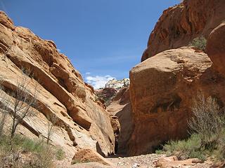 first narrow area 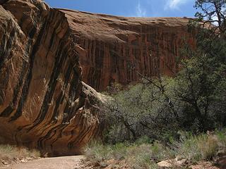 varnish and alcoves abound 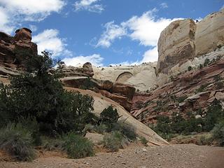 nice colors 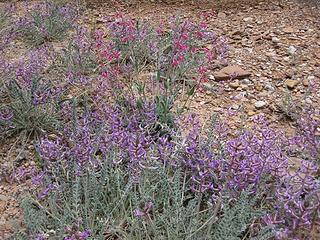 spring in desert equals flowers! 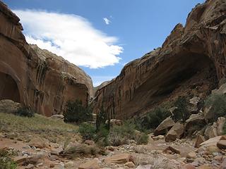 heading downstream 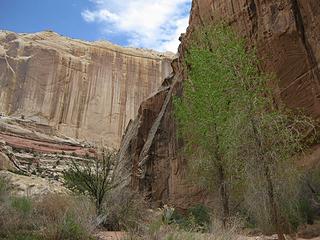 love the cottonwood color 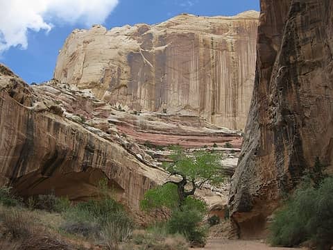 Cottonwood leafing out 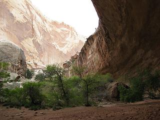 Cowboy cave 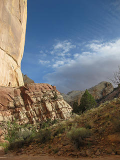 Lower Muley Twist IMG_3320 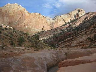 Nearing the narrows at end 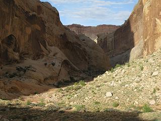 Look at tomorrow's narrows 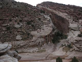 camp canyon with water 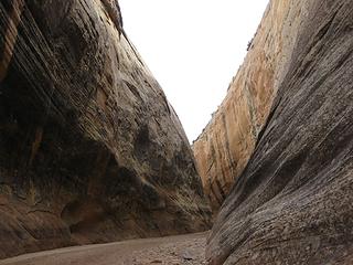 the narrows of Muley Twist 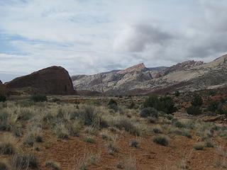 Into Grand Gulch of Halls Creek 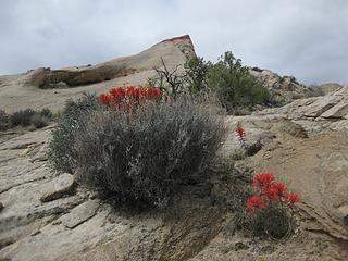 paintbrush 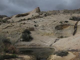 Muley Tanks 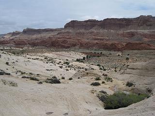 Tanks and Halls creek 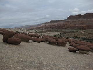 Hamburger rocks 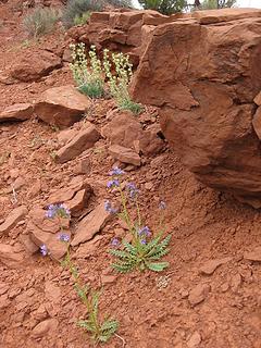 unknown 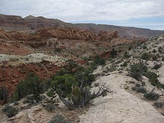 Down Halls Creek 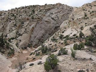 Try this, does it go? 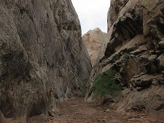 Narrows go in unnamed cnayon 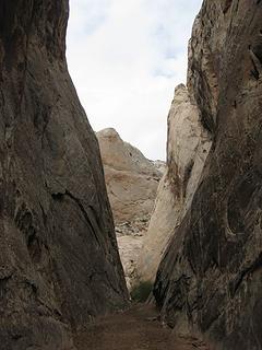 Nice narrows 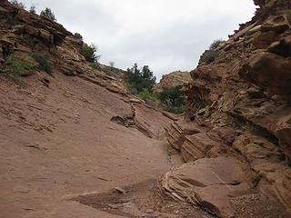 Climbing out into Chinle Formation  A route cutting through Capitol Reef 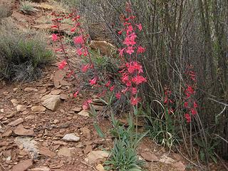 like scarlet gilia but not 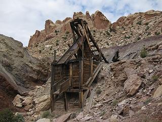 Uranium mine in Chinle at top 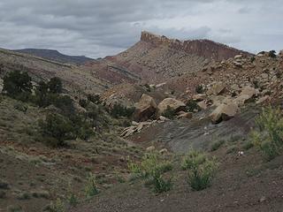 Then descend this 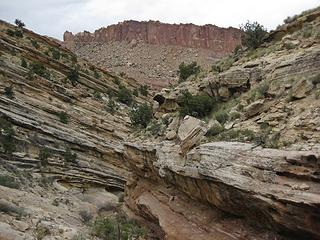 Does this go? 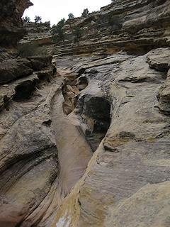 Whew, it does 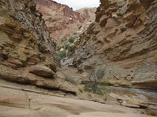 fun exploring, hope it goes 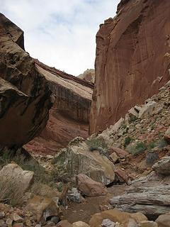 Camp canyon, yes? 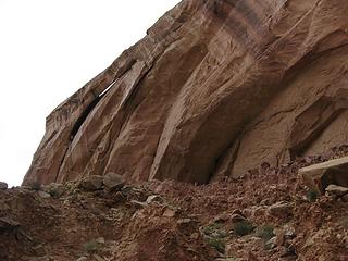 Capitol Reef National Park, Lower Muley Twist Canyon 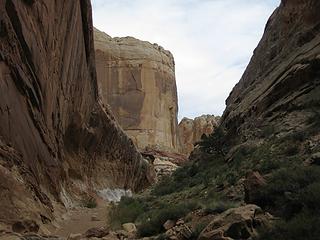 Yeah, it goes to camp! 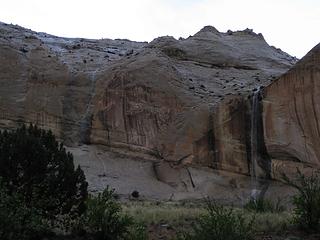 Showers make waterfalls! 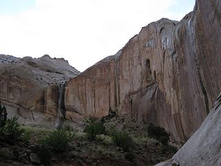 15 minutes old! 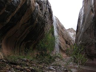 one in narrows 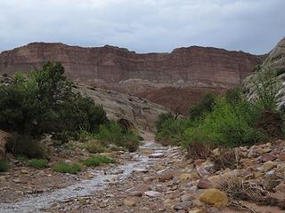 Lower Muley Twist-Grand Gulch of Halls Cr loop 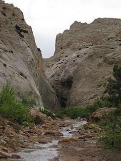 Lower Muley Twist-Grand Gulch of Halls Cr loop 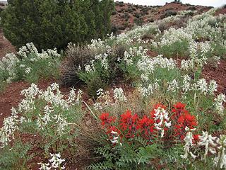 beautiful  claymation 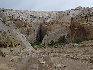 petroglyph canyon 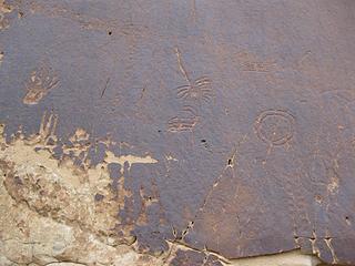 glyphs 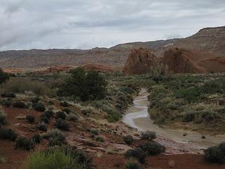 Halls creek and entrada blobs 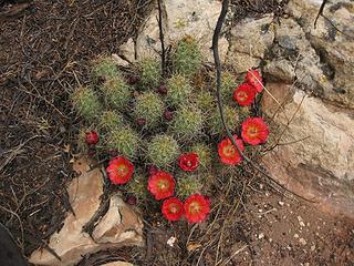 barrel cactus bloom 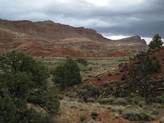 love the walls 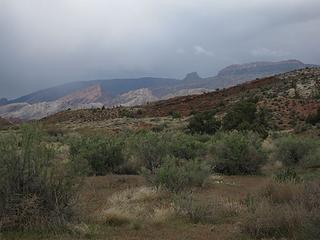 last look to stormy Brimhall Pt 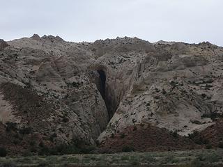 Capitol Reef National Park, Halls Creek 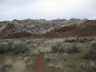 time to climb over 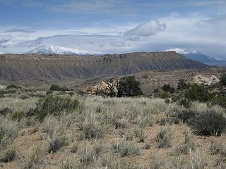 new snow on Henrys 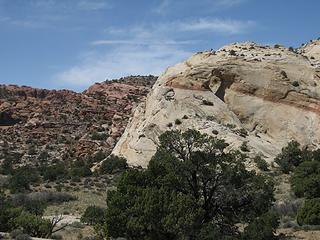 Capitol Reef National Park, Lower Muley Twist Canyon, Cutoff trail 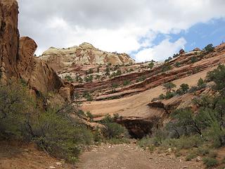 Navaho, Kayenta, and Wingate layers 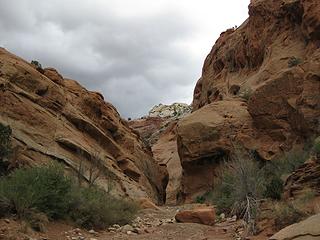 narrow spot 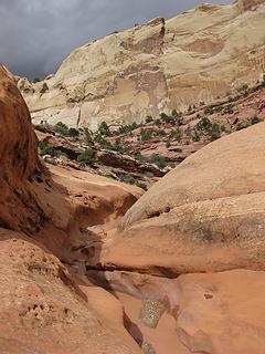 flooded, I'll bypass 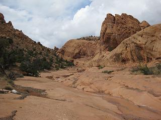 love the wingate slickrock 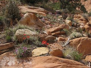 garden 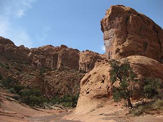 almost out
Tell me, what is it you plan to do with your one wild and precious life?-Mary Oliver
A nation that continues year after year to spend more money on military defense than on programs of social uplift is approaching spiritual doom.
― MLK Jr.
Tell me, what is it you plan to do with your one wild and precious life?-Mary Oliver
A nation that continues year after year to spend more money on military defense than on programs of social uplift is approaching spiritual doom.
― MLK Jr.
|
| Back to top |
  
|
|
David¹
Token Canadian

Joined: 25 Jul 2002
Posts: 3040 | TRs | Pics
Location: The Great White North |
|
David¹
Token Canadian
|
 Tue Apr 26, 2011 11:27 am |
|
|
I believe this is the first trip report I've seen for this particular hike - looks like a great place to explore.
Thanks so much for the report 
|
| Back to top |
|
|
Randy
Cube Rat

Joined: 18 Dec 2001
Posts: 2910 | TRs | Pics
Location: Near the Siamangs |
|
Randy
Cube Rat
|
Tue Apr 26, 2011 1:15 pm |
|
|
Good to see you out in the SW John.
|
| Back to top |
|
|
Matt Lemke
High on the Outdoors

Joined: 15 Jul 2010
Posts: 2052 | TRs | Pics
Location: Grand Junction |
|
Matt Lemke
High on the Outdoors
|
Wed Apr 27, 2011 8:26 am |
|
|
Another great part of Capitol Reef...did you get a good look at the massive overhangs in Lower Muley?
Love the dryfall uncertainties...I know how that goes
Nice photos btw and well done knowing the geology!
|
| Back to top |
|
|
ragman and rodman
Member

Joined: 28 Apr 2005
Posts: 1219 | TRs | Pics
Location: http://rgervin.com/ |
Beautiful area... thanks for the info... we spent 12 days in CRNP last September and didn't quite have time to fit this one into our schedule... in the Muley Twist area we were able to do short day hikes in Headquarters Canyon and Surprise Canyon, but Muley Twist looks nicer... hopefully next time.
|
| Back to top |
|
|
Yana's Dad
Member

Joined: 22 Aug 2007
Posts: 53 | TRs | Pics
Location: Orange, So Cal |
Thanks for the TR. I have not been yet in Capitol Reef and your report certainly convinced me what a great place to visit Capitol Reef is. I guess you had plenty of solitude - this makes a trip better. Great pictures... all these shapes and colors; and water and flowers make it even better.
|
| Back to top |
|
|
marta
wildflower maven

Joined: 07 May 2003
Posts: 1761 | TRs | Pics
|
|
marta
wildflower maven
|
Wed Apr 27, 2011 2:50 pm |
|
|
Beautiful. I love the canyon, solitude and most of all the flowers.  The scarlet gilia like flower is a firecracker penstemon. They can really brighten the desert and a favorite of hummers. The scarlet gilia like flower is a firecracker penstemon. They can really brighten the desert and a favorite of hummers.
|
| Back to top |
|
|
John Morrow
Member
Joined: 03 Apr 2007
Posts: 1526 | TRs | Pics
Location: Roslyn |
Thanks all for the comments!
Marta: Thanks for the flower ID, makes sense to me, penstemon like for sure.
Tell me, what is it you plan to do with your one wild and precious life?-Mary Oliver
A nation that continues year after year to spend more money on military defense than on programs of social uplift is approaching spiritual doom.
― MLK Jr.
Tell me, what is it you plan to do with your one wild and precious life?-Mary Oliver
A nation that continues year after year to spend more money on military defense than on programs of social uplift is approaching spiritual doom.
― MLK Jr.
|
| Back to top |
|
|
|
|


