| Previous :: Next Topic |
| Author |
Message |
Matt
Tea, Earl Grey, Hot


Joined: 30 Jan 2007
Posts: 4307 | TRs | Pics
Location: Shoreline |
|
Matt
Tea, Earl Grey, Hot
|
 Sun Jun 12, 2011 3:15 pm |
|
|
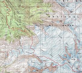
Dates: May 19-20
Destination: Colfax Peak 9440 & Sherman Peak 10160 (Mt. Baker)
Party: Matt, mtnmike
Highlights of the trip:
- Great fun to explore new high points for a different perspective on a familiar peak
- Clear weather and good snow the whole time
- Territorial view at camp on Point 7242
- Leaving the crowds to punch new tracks up the ridge to Colfax
- Vivid steamy volcanism traversing the crater to Sherman
 Mikes GPS Track 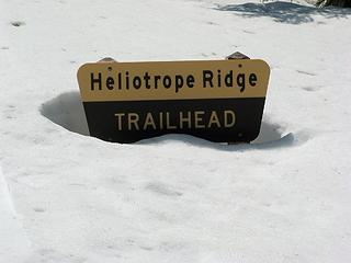 Trailhead sign four feet deep 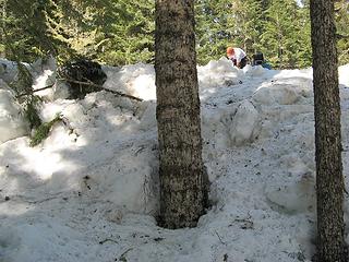 15-foot high avalanche debris along Grouse Creek 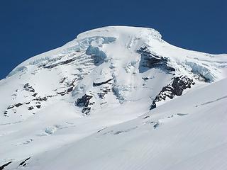 Baker sticking its tongue out at us 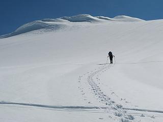 Heading toward Point 7242 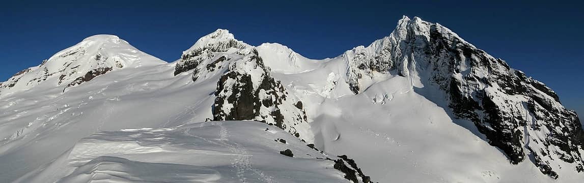 The view from camp: Baker, Colfax & Lincoln 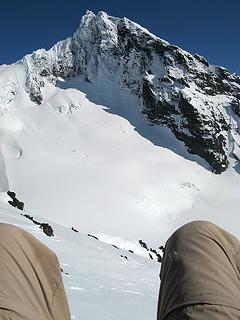 Lincoln & Thunder Glacier while napping  Looking down Thunder Creek to the Twin Sisters 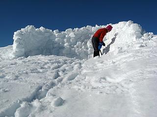 Mike constructing Fortress Torok 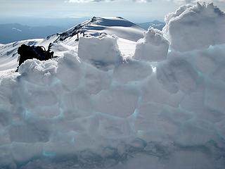 He said there was a cask of Amontillado in here 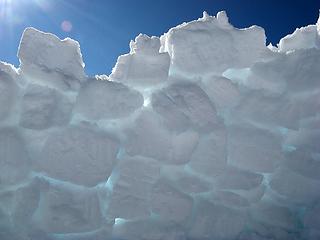 For the love of God, Montresor 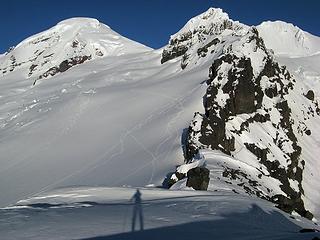 Casting a shadow toward Baker, and lots of ski tracks 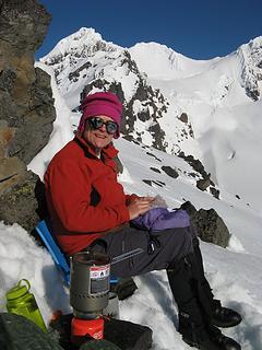 Cooking dinner 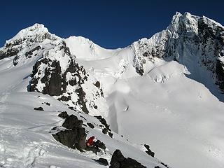 Dinner with a view, but dont slip 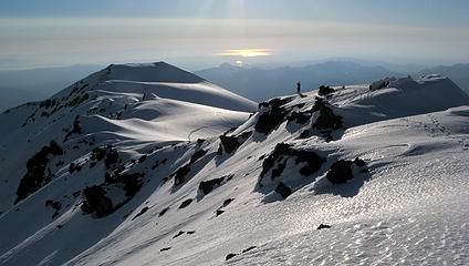 Mike near camp, with sun reflecting on the Sound, 7:28pm 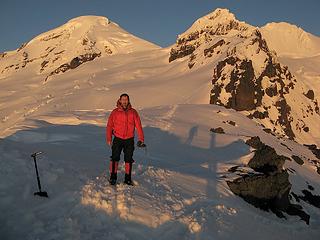 My jacket glowing a bit also 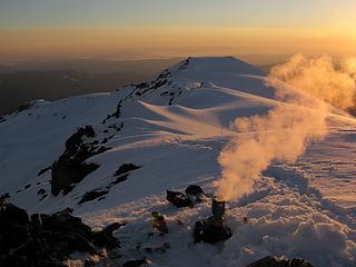 Tea Time, 8:31pm 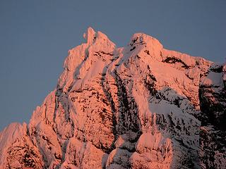 Pink Lincoln, 8:45pm 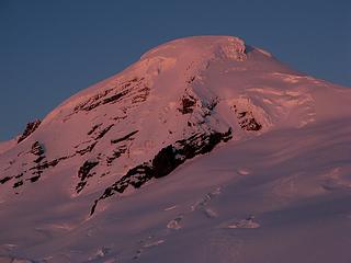 Pink Baker 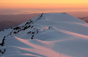 Pastel glow westward 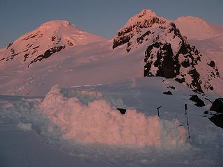 Last Light on Camp 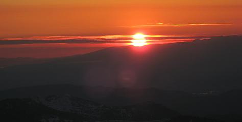 Triple cut sun, 8:50pm 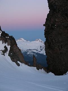 Sunrise descending toward the Twin Sisters 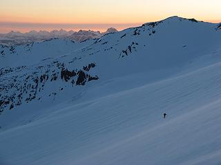 Mike hiking up in the pre-dawn glow 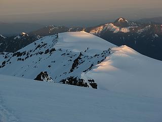 First light touches our camp far below 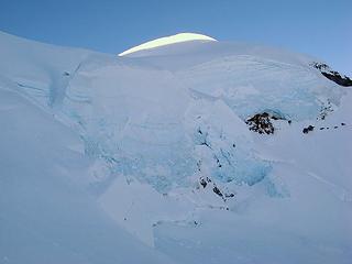 Colfax summit lit up above its ice cliffs 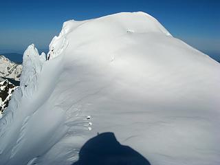 Standing nearly atop Colfaxs east summit, looking at the main summit. 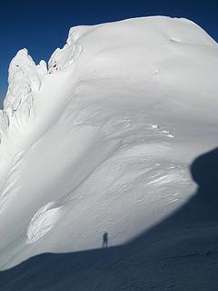 Bypassing the east summit. 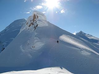 Mike coming around the false summit 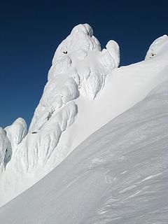 Cool rime, but glad its just a side tower, so we didnt have to climb it. 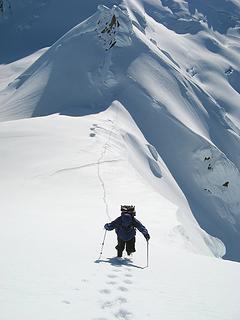 Mike ascending toward the summit 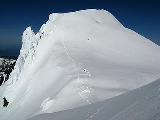 Our tracks to the summit (later photo) 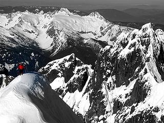 Top of the world on Colfax 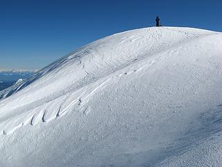 Mike on the summit 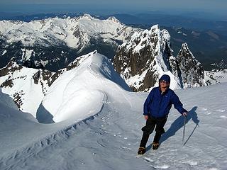 Mike with Twin Sisters & Lincoln 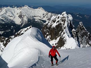 Same for me 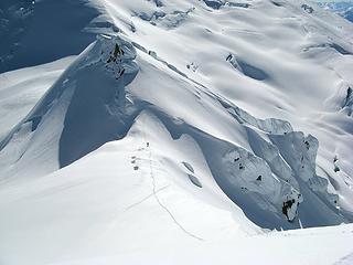 Mike heading back down to the false summit 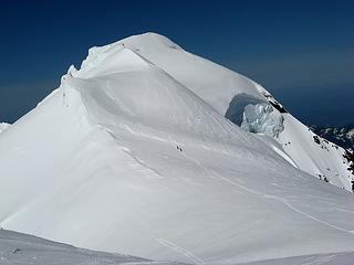 Some skiers following our tracks toward East Colfax 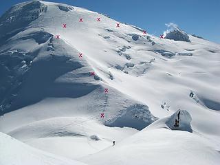 Our line to Sherman Col 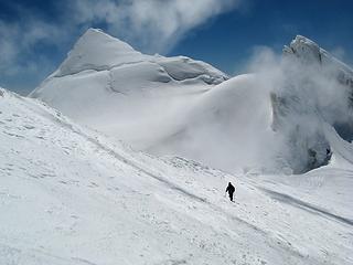 Mike arriving at Sherman col 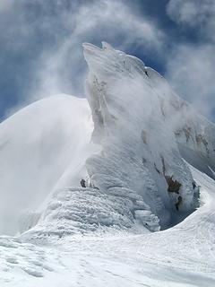 Mike starting the traverse under the fang 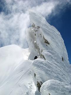 Looking up at the fang 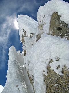 Right under the fang 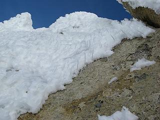 Rime & icicles of doom 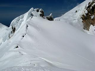 Our tracks running from the fang toward Sherman 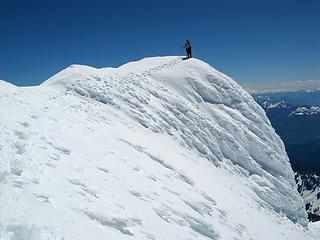 Mike on Sherman summit 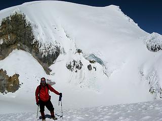 Looking across the crater from Sherman toward Grant 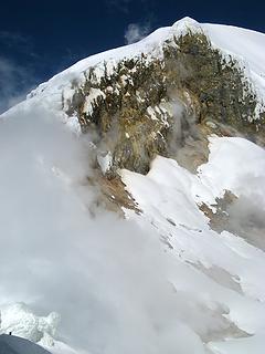 Steam vents around the opposite wall of the crater (note Mikes head in lower left corner) 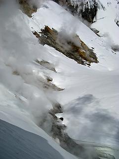 Little puffing vents 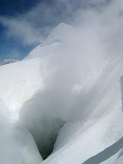 Big deep vent below the fang 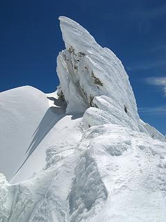 The Fang traverse momentarily clear of steam 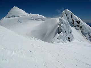 Sherman Crater with its fang & summit 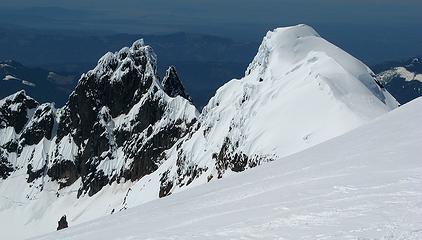 Lincoln & Colfax from Sherman Col 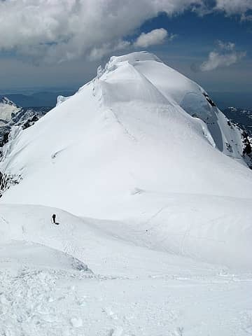 The CD Col and Colfax, from the Hogsback 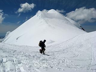 Mike at CD col  The Colfax ice cliffs in daylight
As beacons mountains burned at evening. J.R.R. Tolkien
As beacons mountains burned at evening. J.R.R. Tolkien
|
| Back to top |
  
|
|
Hiker Mama
Member

Joined: 25 Jun 2006
Posts: 3451 | TRs | Pics
Location: Lynnwood |
|
| Back to top |
|
|
dicey
custom title

Joined: 11 May 2004
Posts: 2870 | TRs | Pics
Location: giving cornices a wider berth |
|
dicey
custom title
|
Sun Jun 12, 2011 8:57 pm |
|
|
Nice!
I've passed on this trip twice this spring so far - dang, looks beautiful. 
|
| Back to top |
|
|
Schmidt Alti-Babe
The Ice Queen
Joined: 11 Mar 2008
Posts: 606 | TRs | Pics
Location: Buried by backlogged pictures |
Several very cool and artistic shots Matt. I especially enjoyed the ones of "The Fang". 
|
| Back to top |
|
|
puzzlr
Mid Fork Rocks

Joined: 13 Feb 2007
Posts: 7220 | TRs | Pics
Location: Stuck in the middle |
|
puzzlr
Mid Fork Rocks
|
Sun Jun 12, 2011 9:19 pm |
|
|
That's an amazing trip. Much more interesting than climbing Baker itself. I like your choice of a campsite.
|
| Back to top |
|
|
the Zachster
Member

Joined: 17 Jan 2007
Posts: 4776 | TRs | Pics
Location: dog training |
 Great report and beautiful pics as usual! Great report and beautiful pics as usual! 
"May I always be the kind of person my dog thinks I am"
"May I always be the kind of person my dog thinks I am"
|
| Back to top |
|
|
Magellan
Brutally Handsome

Joined: 26 Jul 2006
Posts: 13116 | TRs | Pics
Location: Inexorable descent |
|
Magellan
Brutally Handsome
|
Sun Jun 12, 2011 10:40 pm |
|
|
Lovely pictures Matt. Very strong work.
|
| Back to top |
|
|
iron
Member

Joined: 10 Aug 2008
Posts: 6392 | TRs | Pics
Location: southeast kootenays |
|
iron
Member
|
Sun Jun 12, 2011 11:04 pm |
|
|
| Matt wrote: | Pastel glow westward |
save this for the calendar
|
| Back to top |
|
|
Matt
Tea, Earl Grey, Hot
Joined: 30 Jan 2007
Posts: 4307 | TRs | Pics
Location: Shoreline |
|
Matt
Tea, Earl Grey, Hot
|
Sun Jun 12, 2011 11:27 pm |
|
|
Yeah, I really like how the light and shadow fold across the curves of the snow in scenes like this.
As beacons mountains burned at evening. J.R.R. Tolkien
As beacons mountains burned at evening. J.R.R. Tolkien
|
| Back to top |
|
|
Matt
Tea, Earl Grey, Hot
Joined: 30 Jan 2007
Posts: 4307 | TRs | Pics
Location: Shoreline |
|
Matt
Tea, Earl Grey, Hot
|
Sun Jun 12, 2011 11:31 pm |
|
|
Steam at Sherman Crater. Note Mike walking out under the fang at right.
As beacons mountains burned at evening. J.R.R. Tolkien
As beacons mountains burned at evening. J.R.R. Tolkien
|
| Back to top |
|
|
peltoms
Member

Joined: 13 Jul 2006
Posts: 1760 | TRs | Pics
Location: Worcester MA |
|
peltoms
Member
|
Mon Jun 13, 2011 4:13 am |
|
|
What a great campsite above Thunder, superb sunset. Colfax and the Fang look like a Himalayan rimed summit.
|
| Back to top |
|
|
Jim Dockery
Member

Joined: 12 Sep 2007
Posts: 3092 | TRs | Pics
Location: Lake Stevens |
Great shots
|
| Back to top |
|
|
GaliWalker
Have camera will use

Joined: 10 Dec 2007
Posts: 4930 | TRs | Pics
Location: Pittsburgh |
|
GaliWalker
Have camera will use
|
Mon Jun 13, 2011 7:20 am |
|
|
Any number of gorgeous photos, but I really like this one:
|
| Back to top |
|
|
RichP
Member

Joined: 13 Jul 2006
Posts: 5634 | TRs | Pics
Location: here |
|
RichP
Member
|
Mon Jun 13, 2011 10:28 am |
|
|
Excellent, Matt! If anyone ever forgets that we live in wild, beautiful country, your trip report is a good reminder of its awesomeness.
|
| Back to top |
|
|
Snowdog
Member

Joined: 21 Jul 2006
Posts: 1028 | TRs | Pics
Location: on (& off) the beaten path |
|
Snowdog
Member
|
Mon Jun 13, 2011 11:22 am |
|
|
great trip Matt! Loved the video too- made me feel like I was there, sorta!
'we don't have time for a shortcut'
'we don't have time for a shortcut'
|
| Back to top |
|
|
|
|
You cannot post new topics in this forum
You cannot reply to topics in this forum
You cannot edit your posts in this forum
You cannot delete your posts in this forum
You cannot vote in polls in this forum
|
Disclosure: As an Amazon Associate NWHikers.net earns from qualifying purchases when you use our link(s). |


