| Previous :: Next Topic |
| Author |
Message |
Aubrey
Member


Joined: 29 Aug 2011
Posts: 24 | TRs | Pics
Location: Bellingham |
|
Aubrey
Member
|
 Mon Sep 19, 2011 12:00 pm |
|
|
Summit Elevation: 8,242
Date Climbed: 9/3/11
Round-trip Distance: 6 miles
Total Elevation Gain: 1,750
After climbing Trappers Peak on 9/2/11 ( https://www.nwhikers.net/forums/viewtopic.php?t=7994148 ), my wife and I decided to take things a little higher and drier. And mellower. So we set our sights on Tiffany Mountain, which is on the eastern edge of the North Cascades in the Tiffany Highlands, just northeast of Winthrop.
I like to climb mountains for many reasons. One of them is for the challenge. But sometimes its nice to just hike something thats relatively easy and tame. And even though it might still be a good workout, I find it mentally relaxing.
Bovine blockage on the drive to the trailhead:
Portion of the road to the trailhead (that 2006 wildfire mustve been massive):
Its amazing to think that, not too far west of here, glaciers and year-round snowfields cover the ground lower than this trailhead:
The east side of the North Cascades is so different from the west side. I couldnt believe how dry it was, and the fine dirt was so ashy and lunar-like that it plumed up after each step.
Having recently moved to Washington from Colorado, I was amazed by how similar this area resembled the foothills of Colorados Front Range, especially the area just west of Fort Collins.
Tiffanys massive baby bump before us:
The weather was awesome. It was sunny and warm with a barely perceptible breeze. We could only hear singing birds and buzzing bees. It was impossibly peaceful and the views were incredibly serene.
The trail was easy to follow and it climbed gently. The only challenge was the altitude. Because we live at sea level now, we could definitely feel the lack of oxygen.
One hour and twenty minutes after starting, we crested the broad summit. We had it all to ourselves, along with a crystal-clear, 360-degree view.
Here was our view to the south:
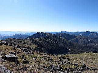 view to the south from Tiffany Mountain 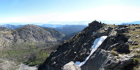 Tiffany Mountain summit 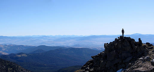 Tiffany Mountain summit, looking east  Tiffany Mountain summit 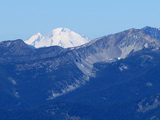 zoomed-in shot of Mt Baker from Tiffany Mountain 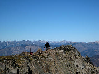 Tiffany Mountain summit 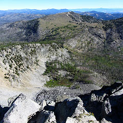 Steep northface of Tiffany Mountain 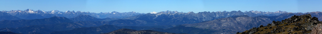 11-photo pan from Tiffany Mountain 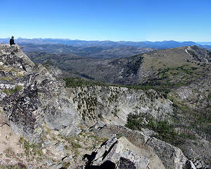 Tiffany Mountain summit 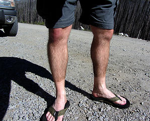 dirt tan 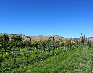 Methow Valley Ciderhouse apple orchard 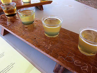 Methow Valley Ciderhouse sampler 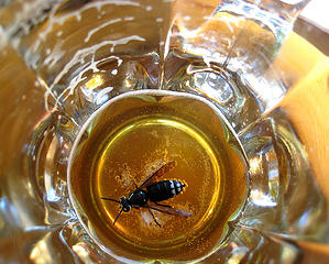 um, I didn't order honey ale 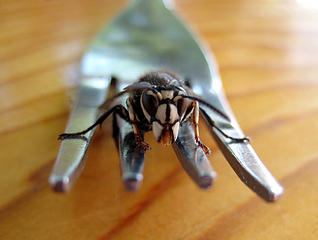 Bee? Wasp? Hornet? Yellowjacket? ...
|
| Back to top |
  
|
|
tigermn
Member

Joined: 10 Jul 2007
Posts: 9242 | TRs | Pics
Location: There... |
|
tigermn
Member
|
Mon Sep 19, 2011 12:35 pm |
|
|
What a great name for a pass (Freezout), and it looks so hot and dry. 
|
| Back to top |
|
|
pasayten
Class of 65...

Joined: 18 Aug 2011
Posts: 536 | TRs | Pics
Location: Winthrop, WA |
|
pasayten
Class of 65...
|
Mon Sep 19, 2011 1:13 pm |
|
|
Your beer liking friend is one of our local Bald Face Hornets (Some call it a White Face Hornet) or scientific name of Dolichovespula maculata... Sometimes, when they get too bothersome at our table while at the PUB, I will just buy them their own beer...  You passed right by our house on your way to/from the TH... We are on the East Chewack Rd 0.9 miles north of the Ciderhouse... lol... Richard and Lynn are great neighbors...
and a trivia item is that the town name Twisp is from an Okanogan Indian name for wasp or yellow jacket...
Glad you enjoyed our little neck of the woods... the dry side...
You passed right by our house on your way to/from the TH... We are on the East Chewack Rd 0.9 miles north of the Ciderhouse... lol... Richard and Lynn are great neighbors...
and a trivia item is that the town name Twisp is from an Okanogan Indian name for wasp or yellow jacket...
Glad you enjoyed our little neck of the woods... the dry side... 
|
| Back to top |
|
|
Tangeman
ride the storm

Joined: 24 Oct 2010
Posts: 485 | TRs | Pics
Location: Cascadia |
|
Tangeman
ride the storm
|
Mon Sep 19, 2011 5:33 pm |
|
|
Tiffany has such a great view. You can do a loop, too, if you start up the Berhardt "trail", bag Clark Peak, then follow the ridge south of Tiffany to Tiffany, and return via Freezout. I did that loop back in july, it's a good one.
"Civilization is a nice place to visit, although I wouldn't want to live there."
My photos
"Civilization is a nice place to visit, although I wouldn't want to live there."
My photos
|
| Back to top |
|
|
|
|
You cannot post new topics in this forum
You cannot reply to topics in this forum
You cannot edit your posts in this forum
You cannot delete your posts in this forum
You cannot vote in polls in this forum
|
Disclosure: As an Amazon Associate NWHikers.net earns from qualifying purchases when you use our link(s). |


