| Previous :: Next Topic |
| Author |
Message |
puzzlr
Mid Fork Rocks


Joined: 13 Feb 2007
Posts: 7220 | TRs | Pics
Location: Stuck in the middle |
|
puzzlr
Mid Fork Rocks
|
 Tue Sep 27, 2011 11:02 pm |
|
|
"Climb either NE or SE to the N or S ridge on brushy rock. Follow the selected ridge to the summit"
1949 Climbers Guide to the Cascade and Olympic Mountains of Washington, Bessemer Mountain
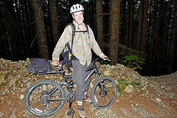
Getting to North Bessemer constitutes most of the challenge in climbing this prominent Middle Fork peak. The guide book approaches recommend coming in the North Fork via Hancock Lake (now on gated roads), or up Quartz Creek road to Blethen Lakes (now overgrown). Most recent ascents are via the SE ridge or traversing from South Bessemer after a 5-mile walk up the Bessemer road. Martin and I chose the latter route, and brought mountain bikes along to speed up the descent, in theory at least.
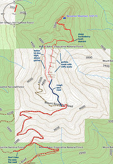 North Bessemer route map and notes 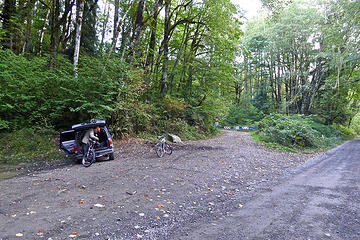 Prepping bikes for the long push up the Bessemer road 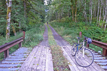 Martin approaches Blowout Creek bridge 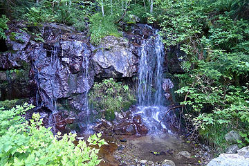 Brawling Creek crossing at 2000' 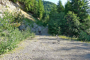 Turnoff to the logging road that heads toward the pass and Bessemer mountain. Do not be tempted by the more maintained level road that keeps going without elevation gain here. 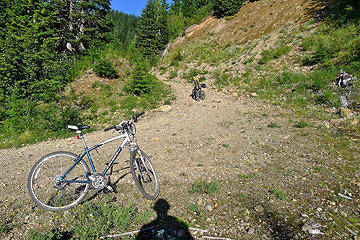 I left my bike here at 3800' because I didn't think I could ride down a gravel road this steep, and sections of it had large rocks. 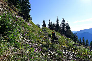 The Bessemer South road is not being maintained and sections like this would be difficult to bike down, but Martin is still taking his bike uphill. 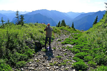 Martin decides this is as far as the bike is going to be useful 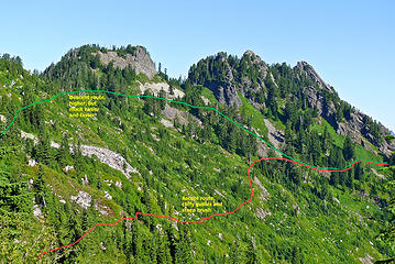 High points on the Bessemer ridge. The summit is the far right high point, but there is an intervening ridge that must be crossed. I recommend a high traverse to avoid cliffy gullies 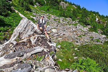 Huge stump. Trees were cut up to the skyline along this ridge 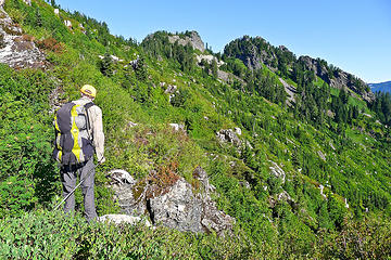 Martin scopes out a cliff, blocking a traverse along across what looked like a reasonable heather/huckleberry slope 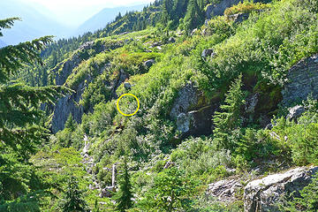 Martin chooses a steep brush downclimb to get through the cliffy gully 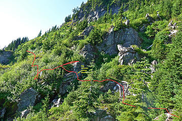 I found a higher but some what challenging upper route 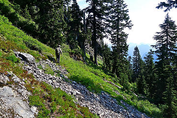 Nearing the SE rib where the traverse was easier with less brush and fewer gullies 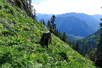 Just before reaching the rib there is a talus slope that has a thick cover crop of ferns and false hellibore, making it impossible to see what you're stepping on. 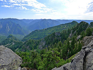 View of SE ridge with location of crossing point and steep huckleberry descent 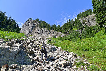 After a steep huckleberry-assisted descent on the east side of the ridge (no pictures), this talus finger leads up to the base of a gully that provides access to the summit ridge 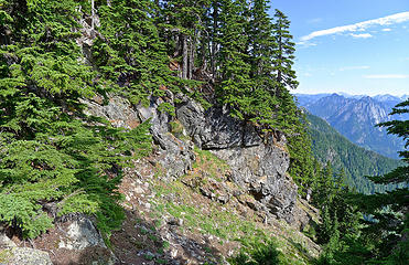 Top of the gully that provides access to the summit ridge 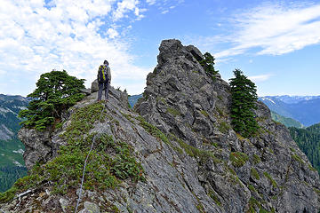 Martin walks across an airy traverse just before the Bessemer summit block. We were using a short rope between us, but were not belaying. 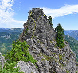 Bessemer summit block. It's possible to go either right or left to avoid the overhanging top block. Both have exposure, but left is easier. 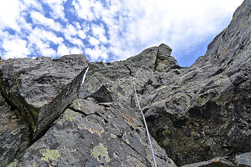 Bessemer summit block. Martin is hidden on a ledge where the rope dissapears 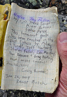 Bessemer summit register 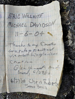 Bessemer summit register 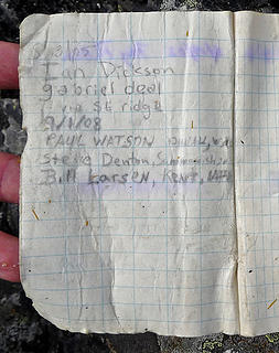 Bessemer summit register 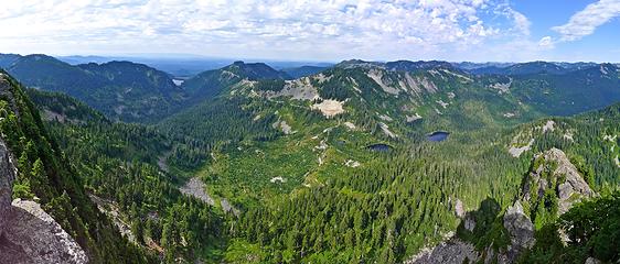 Bessemer pano NW, including Hancocks Comb, Blethen Lakes, Quartz tarn 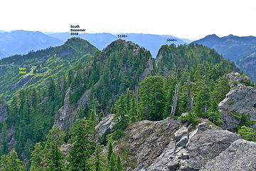 Bessmer ridge. One more 5040+ high point is hidden behind 5120+. 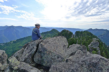 Martin on Bessemer 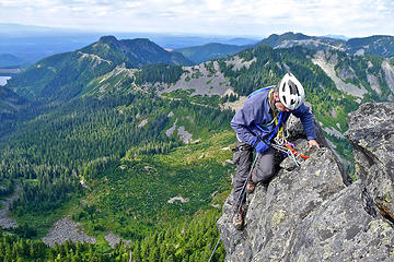 Martin rappelling off Bessemer 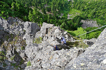 Martin rappelling off Bessemer. Loose sling below is old stuff we cleaned out from below the summit block (we carried it out) 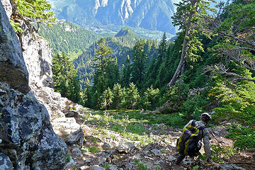 Descending the gully 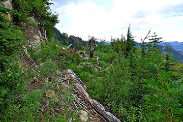 Higher on the slope we had a much easier traverse than down below 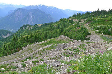 In much less time, the road is visible below  . But Noooooo! Martin's front tire had somehow gotten a flat while it was laying by the side of the road . But Noooooo! Martin's front tire had somehow gotten a flat while it was laying by the side of the road   . On top of that, neither of us had brought a patch kit or a pump. This was not going to be the quick thrill ride down to the car we expected. Martin made the best of it by shifting most of his weight onto the rear tire, and riding down slowly on the flat tire. But it was still 3-4 times faster than walking. We got back to the car at 6:30, 11 hours after starting out. . On top of that, neither of us had brought a patch kit or a pump. This was not going to be the quick thrill ride down to the car we expected. Martin made the best of it by shifting most of his weight onto the rear tire, and riding down slowly on the flat tire. But it was still 3-4 times faster than walking. We got back to the car at 6:30, 11 hours after starting out.
 Martin bemoans his flat front tire, robbing him of a hard-earned thrill ride down the Bessemer road. 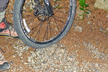 Martin's flat front tire
|
| Back to top |
  
|
|
cartman
Member

Joined: 20 Feb 2007
Posts: 2800 | TRs | Pics
Location: Fremont |
|
cartman
Member
|
Tue Sep 27, 2011 11:39 pm |
|
|
Great pics and beta. Quite involved for less than a mile of actual foot travel, but an interesting route. More fine Middle Fork fun.
|
| Back to top |
|
|
RichP
Member

Joined: 13 Jul 2006
Posts: 5634 | TRs | Pics
Location: here |
|
RichP
Member
|
Thu Sep 29, 2011 4:09 pm |
|
|
Are you working on a Middle Fork guidebook or just enamored with the area?
|
| Back to top |
|
|
puzzlr
Mid Fork Rocks
Joined: 13 Feb 2007
Posts: 7220 | TRs | Pics
Location: Stuck in the middle |
|
puzzlr
Mid Fork Rocks
|
Thu Sep 29, 2011 5:04 pm |
|
|
I have had some thoughts about creating a website for the Middle Fork, and I miss midforc.org. If I do decide to do that, I'll want to launch it with a lot of content so in that sense yes, I'm "working" on it but I'd write up these trip reports anyway. The real answer is that I'm obsessed by the Middle Fork because it's close and wild and has a huge variety of things to do. Much of that is off trail, which is what I really enjoy. I don't like driving too far to get my hiking/exploring jones satisfied.
|
| Back to top |
|
|
RichP
Member
Joined: 13 Jul 2006
Posts: 5634 | TRs | Pics
Location: here |
|
RichP
Member
|
Thu Sep 29, 2011 5:24 pm |
|
|
Great idea about the website  . I am starting to catch the Middle Fork bug for the same reasons as you. . I am starting to catch the Middle Fork bug for the same reasons as you.
|
| Back to top |
|
|
daffish
Member

Joined: 16 Sep 2009
Posts: 282 | TRs | Pics
Location: Dreamtime |
|
daffish
Member
|
Thu Sep 29, 2011 5:43 pm |
|
|
I like the way you add the route lines to some of the photos.
It really helps to tie in the photos to the write-up.
"Be moderate in everything, including moderation" Horace Porter
"Be moderate in everything, including moderation" Horace Porter
|
| Back to top |
|
|
Bernardo
Member

Joined: 08 Feb 2010
Posts: 2174 | TRs | Pics
Location: out and about in the world |
|
Bernardo
Member
|
Thu Sep 29, 2011 10:27 pm |
|
|
Thanks for another nice Middle Fork report.
|
| Back to top |
|
|
EastKing
Surfing and Hiking

Joined: 28 Mar 2007
Posts: 2082 | TRs | Pics
Location: 77 miles from Seattle! |
|
EastKing
Surfing and Hiking
|
Sat Oct 01, 2011 4:44 am |
|
|
Excellent TR on a peak I have always wondered about! Good pics and details.
YouTube | SummitPost
Saw the depths of despair. Now I am salvaging what time I have left on Earth.
YouTube | SummitPost
Saw the depths of despair. Now I am salvaging what time I have left on Earth.
|
| Back to top |
|
|
Magellan
Brutally Handsome

Joined: 26 Jul 2006
Posts: 13116 | TRs | Pics
Location: Inexorable descent |
|
Magellan
Brutally Handsome
|
Fri Apr 26, 2013 2:58 pm |
|
|
Nice work! It is crazy how difficult some of these 5k peaks on the Middle Fork are.
|
| Back to top |
|
|
like2thruhike
Member
Joined: 28 May 2009
Posts: 1288 | TRs | Pics
Location: Seattle |
Next time try disengaging one side of the tire bead and packing the tire with leaves and duff. Stuff it full then reseat the tire bead.
A buddy of mine claims this "works" or at least won't do as much damage to the rim as the weight transfer technique.
|
| Back to top |
|
|
Now I Fly
Member
Joined: 07 Jun 2018
Posts: 467 | TRs | Pics
|
This is a great TR, Monty!
Seeing Bessemer from Rooster Mountain the other day has really peaked my interest in this beautiful Peak!
Thanks for the report!
|
| Back to top |
|
|
|
|


