| Previous :: Next Topic |
| Author |
Message |
tgleason
Member


Joined: 27 Jan 2010
Posts: 21 | TRs | Pics
|
|
tgleason
Member
|
 Wed Nov 02, 2011 6:46 pm |
|
|
Where was it and can u still see anything the remains?
Thank You,
Tami Gleason 
|
| Back to top |
  
|
|
Dayhike Mike
Bad MFKer

Joined: 02 Mar 2003
Posts: 10958 | TRs | Pics
Location: Going to Tukwila |
I'm pretty sure Camp Brown posts here under the pseudonym Quark.
Wait, no, that's Kim Brown. Carry on.
"There is only one basic human right, the right to do as you damn well please. And with it comes the only basic human duty, the duty to take the consequences." -P.J. O'Rourke
"Ignorance is natural. Stupidity takes commitment." -Solomon Short
"There is only one basic human right, the right to do as you damn well please. And with it comes the only basic human duty, the duty to take the consequences." -P.J. O'Rourke
"Ignorance is natural. Stupidity takes commitment." -Solomon Short
|
| Back to top |
|
|
Backpacker Joe
Blind Hiker

Joined: 16 Dec 2001
Posts: 23956 | TRs | Pics
Location: Cle Elum |
| Dayhike Mike wrote: | | I'm pretty sure Camp Brown posts here under the pseudonym Quark.
Wait, no, that's Kim Brown. Carry on. |
Ya wise guy!
There are a few small remains. In the old days when I/we/you had to ford the creek there I remember a could old wooden artifacts. Now that you can walk across the bridge you might head up there a take a look.
"If destruction be our lot we must ourselves be its author and finisher. As a nation of freemen we must live through all time or die by suicide."
Abraham Lincoln
"If destruction be our lot we must ourselves be its author and finisher. As a nation of freemen we must live through all time or die by suicide."
Abraham Lincoln
|
| Back to top |
|
|
Yana
Hater

Joined: 04 Jun 2004
Posts: 4212 | TRs | Pics
Location: Out Hating |
|
Yana
Hater
|
Wed Nov 02, 2011 7:17 pm |
|
|
BPJ - I don't think she's going to be walking across the bridge and taking a look if she doesn't know where it is (see OP's first question). 
PLAY SAFE! SKI ONLY IN CLOCKWISE DIRECTION! LET'S ALL HAVE FUN TOGETHER!
PLAY SAFE! SKI ONLY IN CLOCKWISE DIRECTION! LET'S ALL HAVE FUN TOGETHER!
|
| Back to top |
|
|
Backpacker Joe
Blind Hiker
Joined: 16 Dec 2001
Posts: 23956 | TRs | Pics
Location: Cle Elum |
| Yana wrote: | | BPJ - I don't think she's going to be walking across the bridge and taking a look if she doesn't know where it is (see OP's first question). |
OOPS! Thanks Yans.
"1928-29 Railroad extended to 1 mile past Taylor River. Camp Brown is built (named after Robert Brown, civil engineer for laying track on the Middle Fork railroad who was run over and killed by a backing locomotive in 1928)."
Middle Fork Snoqualmie history. Camp Brown used to be on the Middle Fork of the Snoqualmie river just outside of North Bend Wash.
"If destruction be our lot we must ourselves be its author and finisher. As a nation of freemen we must live through all time or die by suicide."
Abraham Lincoln
"If destruction be our lot we must ourselves be its author and finisher. As a nation of freemen we must live through all time or die by suicide."
Abraham Lincoln
|
| Back to top |
|
|
tgleason
Member
Joined: 27 Jan 2010
Posts: 21 | TRs | Pics
|
|
tgleason
Member
|
Thu Nov 03, 2011 11:07 am |
|
|
thanks for the four posts that i got. i will be going up to the gateway trail head tomorrow (Friday 11/4/11) with my brother and my fiance. I know that my brother (an avid NW hiker) told me about camp brown. I still don't know where it is. I have looked on the internet but to no avail. Was camp brown near the taylor river or is it in the area of the bridge crossing the snoqualmie river? I would like some more clarification. Please help!
Tami Gleason
|
| Back to top |
|
|
Slugman
Its a Slugfest!

Joined: 27 Mar 2003
Posts: 16874 | TRs | Pics
|
|
Slugman
Its a Slugfest!
|
Thu Nov 03, 2011 11:22 am |
|
|
|
| Back to top |
|
|
kbatku
Questionable hiker

Joined: 17 Sep 2007
Posts: 3330 | TRs | Pics
Location: Yaquima |
|
kbatku
Questionable hiker
|
Thu Nov 03, 2011 5:04 pm |
|
|
Try Googling "pmac nworb" and see if that helps.
|
| Back to top |
|
|
Slugman
Its a Slugfest!

Joined: 27 Mar 2003
Posts: 16874 | TRs | Pics
|
|
Slugman
Its a Slugfest!
|
Thu Nov 03, 2011 5:20 pm |
|
|
|
| Back to top |
|
|
JimK
Member

Joined: 07 Feb 2002
Posts: 5606 | TRs | Pics
Location: Ballard |
|
JimK
Member
|
Thu Nov 03, 2011 7:47 pm |
|
|
Google brought up this: Camp Brown
Suppose to be very near the new campground.
|
| Back to top |
|
|
mtnresqr
Member
Joined: 18 May 2010
Posts: 48 | TRs | Pics
|
|
mtnresqr
Member
|
Fri Nov 04, 2011 8:33 am |
|
|
From what I remember as a kid, Camp Brown was a USFS Guard Station alongside Middle Fork road. Like around late 1950's. A small Ranger Station in a wooden cabin. Then the log cabin got rickety or damaged and was torn down. The USFS put a concrete pad down, to park a small camping trailer, for a seasonal USFS place. Maybe around early 1960's.
And, back before that, over on Rainy Creek, on other side of MF river, there was a water works, that provided water for the camp, thru some 7-8 inch wooden water pipe. the remains of that pipe still shows in a few places, by the wire wrapping remaining. Like continuous coils of wire that was used to wrap the wooden pieces to hold it into a pipe. On the far side of Rainy Creek, near the new bridge on the new Pratt Connector trail. That is because in the past, Camp Brown was a fairly large timber company logging camp. Must have had a water pipe system across Middle Fork River.
The location of the concrete pad, is at the wide spot on MF road about three fourths mile before the Middle Fork Trail Head parking lot. This 'wide spot' gets used as a once popular camping spot in Summer. Park cars and wander out an old road to river.
|
| Back to top |
|
|
tgleason
Member
Joined: 27 Jan 2010
Posts: 21 | TRs | Pics
|
|
tgleason
Member
|
Sat Nov 05, 2011 1:21 pm |
|
|
thank you for your information about camp brown. my brother took me up to hike the new pratt river connector trail along with my fiance. we stopped at the spot that you talked about. we got out of the car and he swiped with his boot where the concrete slab was. pretty cool i might add. my brother remembers camp brown when he was hiking up there in the 70s.
Tami Gleason
|
| Back to top |
|
|
lopper
off-route

Joined: 22 Jan 2002
Posts: 845 | TRs | Pics
|
|
lopper
off-route
|
Sat Nov 05, 2011 3:52 pm |
|
|
There was a "single-wide" prefab trailer on the slab until the mid 1970's. It was always locked and un-manned during my comings and goings 1968-1974.
Also there was a wall-sized wooden sign-board on the east side of the parking area next to the trailer. I think that the sign listed distances to the main road-accessed trailheads further up the roads east and north. I wonder if anyone has a picture of that sign? It was big....like the one at US10/Denny Creek in the old days.
South of the Guard Station, at the riverside (in the mid 1970s), there was a large stump wrapped with steel cables where a footbridge had once crossed the MFK to the Rainy Cr. Trail. (not to be confused with the wire bridge at the Pratt confluence).
When I worked for the USFS in Wenatchee in 1978, I had a supervisor who had been stationed at Camp Brown for a couple of summers in the late 1950s or early 1960s.
|
| Back to top |
|
|
tgleason
Member
Joined: 27 Jan 2010
Posts: 21 | TRs | Pics
|
|
tgleason
Member
|
Sun Nov 06, 2011 1:26 pm |
|
|
thank you so much for your information. you gave me more information than any previous posts.
Tami Gleason 
|
| Back to top |
|
|
lopper
off-route
Joined: 22 Jan 2002
Posts: 845 | TRs | Pics
|
|
lopper
off-route
|
Tue Jan 17, 2012 5:11 pm |
|
|
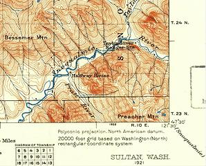
Here is more grist for the Camp Brown discussion mill. See 1921 USGS map below.
"Halfway House" at the Pratt Confluence. Halfway to where? North Bend to Goldmyer?
"Taylor River Ranger Station" Located across the MFK from where the future Taylor River Campground (1950s-70s) would be.
Pre-CCC, the only land route up alongside the MFK is on the south bank.
 1921
|
| Back to top |
|
|
|
|


 No, doing it the right way didn't help. Not specific enough or something.
