| Previous :: Next Topic |
| Author |
Message |
elderbob
Member


Joined: 27 Jun 2004
Posts: 75 | TRs | Pics
Location: Phoenix |
|
elderbob
Member
|
 Tue Mar 20, 2012 7:31 am |
|
|
Thanks for the photo Lotus. Is this shelter (Falls Creek) the one near Graywolf? It is not on the list of all the shelters posted by Paul Gleeson, unless he just refers to it as "Falls" shelter?
You have the word "Beach" which is confusing me. Just wondering if you mean it is near a beach?
|
| Back to top |
  
|
|
Lotus54
Member

Joined: 17 Oct 2010
Posts: 381 | TRs | Pics
Location: Port Angeles |
|
Lotus54
Member
|
Tue Mar 20, 2012 11:48 am |
|
|
It is the one near falls creek on the coast. NOT the one up the Greywolf (although I have some old pics of that also someplace).
Mark
|
| Back to top |
|
|
RodF
Member

Joined: 01 Sep 2007
Posts: 2593 | TRs | Pics
Location: Sequim WA |
|
RodF
Member
|
Wed Mar 28, 2012 12:49 pm |
|
|
| Lotus54 wrote: | | It is the one near falls creek on the coast. |
Where is Falls Creek on the coast?
(There was a shelter at Cedar Creek, south of Norwegian Memorial...)
"of all the paths you take in life, make sure a few of them are dirt" - John Muir
"the wild is not the opposite of cultivated. It is the opposite of the captivated - Vandana Shiva
"of all the paths you take in life, make sure a few of them are dirt" - John Muir
"the wild is not the opposite of cultivated. It is the opposite of the captivated - Vandana Shiva
|
| Back to top |
|
|
Lotus54
Member
Joined: 17 Oct 2010
Posts: 381 | TRs | Pics
Location: Port Angeles |
|
Lotus54
Member
|
Wed Mar 28, 2012 5:18 pm |
|
|
South part of third beach. Just before Taylor pt
|
| Back to top |
|
|
RodF
Member
Joined: 01 Sep 2007
Posts: 2593 | TRs | Pics
Location: Sequim WA |
|
RodF
Member
|
Thu Mar 29, 2012 5:09 pm |
|
|
| Lotus54 wrote: | | Falls Creek... South part of third beach. Just before Taylor pt |
Thanks, Mark!
Wow! That bumps the count of Olympic trail shelters (listed in the first posting in this thread) to 177.
(When searching for this, I also noticed there's another coastal "Falls Creek" crossing, a tributary of Goodman Creek, on the Hoh Head trail.)
"of all the paths you take in life, make sure a few of them are dirt" - John Muir
"the wild is not the opposite of cultivated. It is the opposite of the captivated - Vandana Shiva
"of all the paths you take in life, make sure a few of them are dirt" - John Muir
"the wild is not the opposite of cultivated. It is the opposite of the captivated - Vandana Shiva
|
| Back to top |
|
|
RPBrown
Member

Joined: 14 Aug 2005
Posts: 126 | TRs | Pics
|
|
RPBrown
Member
|
Fri Mar 30, 2012 12:18 am |
|
|
Not a trail shelter but while we're on the subject here's Interrorem in 1946. My auntie manned the station June-September of 46 and spent the summer fishing the Duckabush.
|
| Back to top |
|
|
elderbob
Member
Joined: 27 Jun 2004
Posts: 75 | TRs | Pics
Location: Phoenix |
|
elderbob
Member
|
Wed Apr 11, 2012 11:13 am |
|
|
Check out the following link about historical maps of ONF and ONP
https://www.nwhikers.net/forums/viewtopic.php?t=7997563
There is one of the original plans for an overnight shelter on my Web site. RodF did the scanning and some of the stitching. I just put everything together in one place. Rod has posted a few of the maps earlier. Now they are all together.
|
| Back to top |
|
|
Ancient Ambler
Member

Joined: 15 May 2007
Posts: 1092 | TRs | Pics
Location: Bainbridge Island |
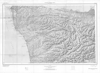
We were going through some stuff and came across an old map of mine I had not seen for many years, the USGS Olympic National Park and Vicinity 1:125K topo from 1957. It was amazing how many of the long-gone ONP shelters referred to in this thread are included on this map. Had it scanned today in high-res gray-tone (color scanning was more expensive than I could stomach) and have uploaded the 23 MB jpg file to flickr. Contour interval is 200 feet. The paper map size is 33" x 45" and the dimensions of the jpg I uploaded to flickr are 13,472 X 9694. As far as I could tell, this map was not linked or loaded elsewhere in this thread, so I'm hoping it will be of some interest to those who enjoyed the old trail shelters. Am hoping this file won't be too unwieldly to view; if it would be better presented some other way, let me know. To see it full-size, you'll need to click on "view original" at the top of the image page.
 1957 USGS ONP & vicinity topo scan
|
| Back to top |
|
|
reststep
Member
Joined: 17 Dec 2001
Posts: 4757 | TRs | Pics
|
|
reststep
Member
|
Sat Jun 23, 2012 12:11 pm |
|
|
Thanks for posting the map AA.
We sure have lost a lot of shelters.
The group "Friends of Olympic Trail Shelters" has helped restore some of the shelters. Are they still in existence?
The park service is restoring some of them now also I believe.
"The mountains are calling and I must go." - John Muir
"The mountains are calling and I must go." - John Muir
|
| Back to top |
|
|
elderbob
Member
Joined: 27 Jun 2004
Posts: 75 | TRs | Pics
Location: Phoenix |
|
elderbob
Member
|
Sat Jun 23, 2012 4:16 pm |
|
|
Hi Reststop
Yes, the Friends are still around and active. Just ask Rodf. He has been working with them.
Bob aka Elder Bob
|
| Back to top |
|
|
Magellan
Brutally Handsome

Joined: 26 Jul 2006
Posts: 13116 | TRs | Pics
Location: Inexorable descent |
|
Magellan
Brutally Handsome
|
Sat Jun 23, 2012 6:24 pm |
|
|
Amazing map! I am stunned to think that 177 shelters have existed at one point in time.
|
| Back to top |
|
|
Lotus54
Member
Joined: 17 Oct 2010
Posts: 381 | TRs | Pics
Location: Port Angeles |
|
Lotus54
Member
|
Sat Jun 23, 2012 6:32 pm |
|
|
I'd sure like to get the full sized scan...
I recall when so many were being burnt down- many by one person.
I still remember when he came through after burning down upper Cameron.
We counted 29 sub alpine furs killed and he left a huge mess.
Yeah, that really helped the wilderness alright.
Mark
|
| Back to top |
|
|
Ancient Ambler
Member
Joined: 15 May 2007
Posts: 1092 | TRs | Pics
Location: Bainbridge Island |
| Lotus54 wrote: | | I'd sure like to get the full sized scan...
I recall when so many were being burnt down- many by one person.
I still remember when he came through after burning down upper Cameron.
We counted 21 sub alpine furs killed and he left a huge mess.
Yeah, that really helped the wilderness alright.
Mark |
pm sent.
If the guy burned the Upper Cameron shelter right where it was standing, I'm not surprised he killed that many sub-alpine firs. There was a really nice stand of them close to the north side of the shelter. Hard to understand that kind of thinking.
06-24-12 NOTE: I got a message that it was difficult to view the scanned 1957 map via the flickr link on nwhikers.net, so I have emailed copies of the scanned files in pdf and jpg format to elderbob in hopes that he'll be able to set up a link so the 1957 map can be more easily viewed here.
|
| Back to top |
|
|
elderbob
Member
Joined: 27 Jun 2004
Posts: 75 | TRs | Pics
Location: Phoenix |
|
elderbob
Member
|
Sun Jun 24, 2012 7:12 am |
|
|
| Ancient Ambler wrote: | | 06-24-12 NOTE: I got a message that it was difficult to view the scanned 1957 map via the flickr link on nwhikers.net, so I have emailed copies of the scanned files in pdf and jpg format to elderbob in hopes that he'll be able to set up a link so the 1957 map can be more easily viewed here. |
I got the maps and put them on my Website. You should be able to view the maps in their true size without any trouble. They load slowly, so be patient. I will add a link to them later on my Website. For the time being use these links to see the entire maps.
http://www.windsox.us/1957_Map/1957USGSONP&vicinitytopopdf.pdf
http://www.windsox.us/1957_Map/1957USGSONP&vicinitytoposcan.jpg
There may be problems using the jpg link from this posting. When I tried it, I got a Hot Link error message. Just copy the link and paste it into your browser address bar. It should work.
Bob aka Elder Bob
|
| Back to top |
|
|
elderbob
Member
Joined: 27 Jun 2004
Posts: 75 | TRs | Pics
Location: Phoenix |
|
elderbob
Member
|
Sun Jun 24, 2012 7:37 am |
|
|
Use this link to my History page. It has the links on it also. You should be able to click on them to see the maps. If you have trouble, let me know. They are large files and may not work for you but work for me.
http://www.windsox.us/VISITOR/history.html
Thanks,
Bob aka Elder Bob
|
| Back to top |
|
|
|
|


