| Previous :: Next Topic |
| Author |
Message |
raising3hikers
Member


Joined: 21 Sep 2007
Posts: 2344 | TRs | Pics
Location: Edmonds, Wa |
Finally, a good weekend forecast. With the nice weather, I had to get out and climb Mt. Logan. I left the Easy Pass TH at 8am Saturday after getting my backcountry permit in Marblemount. I quickly hit snow and lost the trail through the forest. I thought it would have been a good idea to stay to the right and be in the forest as soon as I hit brush. That wasn't the best idea but I eventually made it up to some nice snowy slopes below the pass and followed it up. At the pass, I could see my destination way off in the distance. I wondered if I was actually going to make it happen.
 my first view of Logan from Easy Pass 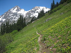 Mesahchie Pk above the meadow  glacier lilies  the view of the basin from camp  waterfalls 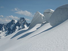 Goode and seracs 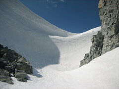 the wind blown snow wall  Logan's summit, easier than it looks  Sahale and Boston  Buckner to Forbidden  big slab below Pincer Pk  first light on the glacier lilies with Logan in the background  false helborne
|
| Back to top |
  
|
|
twodogdad
Member
Joined: 21 Nov 2006
Posts: 846 | TRs | Pics
Location: seattle |
You have become a master of understatement, among other things  N
N
|
| Back to top |
|
|
Backpacker Joe
Blind Hiker

Joined: 16 Dec 2001
Posts: 23956 | TRs | Pics
Location: Cle Elum |
You guys are animals! Very nice work. I wish I knew where you found all your energy. LOL!
"If destruction be our lot we must ourselves be its author and finisher. As a nation of freemen we must live through all time or die by suicide."
Abraham Lincoln
"If destruction be our lot we must ourselves be its author and finisher. As a nation of freemen we must live through all time or die by suicide."
Abraham Lincoln
|
| Back to top |
|
|
iron
Member

Joined: 10 Aug 2008
Posts: 6392 | TRs | Pics
Location: southeast kootenays |
|
iron
Member
|
 Sun Jul 08, 2012 11:24 pm |
|
|
glad you made it happen. pretty short first day compared to what i thought you'd be dealing with. i'd be interested to see the pics of the snow filling the crevasse as well as what it was like walking on the avi debris.
|
| Back to top |
|
|
puzzlr
Mid Fork Rocks

Joined: 13 Feb 2007
Posts: 7220 | TRs | Pics
Location: Stuck in the middle |
|
puzzlr
Mid Fork Rocks
|
Mon Jul 09, 2012 12:50 am |
|
|
A Hemmingway of TRs. Each word and picture counts. I continue to be amazed at how you can cover ground, on trail or off.
|
| Back to top |
|
|
silence
Member

Joined: 25 Apr 2005
Posts: 4420 | TRs | Pics
|
|
silence
Member
|
Mon Jul 09, 2012 6:04 am |
|
|
OK .. now you've really outdone yourself bud!!! amazing solo climb ..
beautiful photos too .. i remember that big slab from jason's and kyle's recent climb/ski
REALLY looking forward to what more you have in store this season .. challenger perhaps?
PHOTOS
FILMS
Keep a good head and always carry a light bulb. Bob Dylan
PHOTOS
FILMS
Keep a good head and always carry a light bulb. Bob Dylan
|
| Back to top |
|
|
Sadie's Driver
Sadie's Driver

Joined: 24 Apr 2006
Posts: 1763 | TRs | Pics
Location: Welcome Pass |
An overnighter? You ARE (somewhat) human!   Beautiful. Beautiful.
Four-paw buddy lets me tag along!
Four-paw buddy lets me tag along!
|
| Back to top |
|
|
Snowdog
Member

Joined: 21 Jul 2006
Posts: 1028 | TRs | Pics
Location: on (& off) the beaten path |
|
Snowdog
Member
|
Mon Jul 09, 2012 9:27 am |
|
|
nicely done- just 'a walk in the park' for you...... 
'we don't have time for a shortcut'
'we don't have time for a shortcut'
|
| Back to top |
|
|
raising3hikers
Member
Joined: 21 Sep 2007
Posts: 2344 | TRs | Pics
Location: Edmonds, Wa |
| iron wrote: | | pretty short first day compared to what i thought you'd be dealing with. i'd be interested to see the pics of the snow filling the crevasse as well as what it was like walking on the avi debris. |
That first mile off trail is really tame, but that brush a little further up will be worse in a few years. Manageable now but will need snow cover in years to come to make it easier. A mid June trip would be ideal.
As for walking on the small slide area on the glacier, it was just like the rest of the snow. Ankle deep and firm below that, I'd say it was at least 2-3 days old by the way it was melted. I didn't get a good picture of the filled in crevasse but it was actually mounded up a bit at that spot. The filled in part was about 5' wide and as the slide rounded the corner, it was maybe 15' wide. It definitely helped me out or else I would have had to try the left side of the glacier and travel above the crevasse in limited room. The location of this is where the Douglas glacier narrows at around 8000'. The route might become impassible soon
 Here's a pic of another crevasse near that area, that's all I got
|
| Back to top |
|
|
b00
Member

Joined: 29 Sep 2003
Posts: 1144 | TRs | Pics
|
|
b00
Member
|
Tue Jul 10, 2012 1:04 am |
|
|
| raising3hikers wrote: | | At the pass, I could see my destination way off in the distance. I wondered if I was actually going to make it happen. |
logan really looks far away from easy pass, but next time i'm there, it is going to look a lot closer after reading your t/r
:>)
|
| Back to top |
|
|
Fatal Justice
UW Huskies UW
Joined: 15 Oct 2011
Posts: 161 | TRs | Pics
Location: Lynnwood WA |
| raising3hikers wrote: | | 10800' elevation gain-8000' day 1 |
Not quite Uli Steck, but pretty good nonetheless. 
Always remember you're unique, just like everyone else lol
Always remember you're unique, just like everyone else lol
|
| Back to top |
|
|
wamtngal
Member

Joined: 13 Jun 2004
Posts: 2382 | TRs | Pics
Location: somewhere |
|
wamtngal
Member
|
Tue Jul 10, 2012 4:33 pm |
|
|
Opinions expressed here are my own.
|
| Back to top |
|
|
wildernessed
viewbagger

Joined: 31 Oct 2004
Posts: 9275 | TRs | Pics
Location: Wenatchee |
Very Nice, your not in a hurry to check off the T100 list are you ?
Living in the Anthropocene
Living in the Anthropocene
|
| Back to top |
|
|
Magellan
Brutally Handsome

Joined: 26 Jul 2006
Posts: 13116 | TRs | Pics
Location: Inexorable descent |
|
Magellan
Brutally Handsome
|
Tue Jul 10, 2012 11:10 pm |
|
|
Nice work E.
|
| Back to top |
|
|
Don
Member

Joined: 25 Apr 2005
Posts: 2013 | TRs | Pics
Location: Fairwood, WA |
|
Don
Member
|
Wed Jul 11, 2012 7:07 am |
|
|
An incredible solo feat! Serious motivation! That's a huge amount of elevation gain.
|
| Back to top |
|
|
|
|


 (
(