| Previous :: Next Topic |
| Author |
Message |
Tom_Sjolseth
Born Yesterday


Joined: 30 May 2007
Posts: 2652 | TRs | Pics
Location: Right here. |
August 8-11, 2013
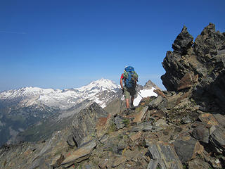
Originally this trip was supposed to end at Trinity via High Pass and Buck Creek Pass, but intense electrical storms had us changing our itinerary. This is essentially a repeat of a trip Birddog and I did in August of 2011, but this time we kept on the N side of the range instead of the S. We wound up traversing the Richardson, Pilz, and Butterfly Glaciers. The descent down Thunder Creek was made more pleasant thanks to very recent work by a trail crew w/ horses. Those must be some cowboys to get horses up there! My hat is off.
We started from and ended at White River TH. We ascended Clark via the Klenke/Sjolseth cross-country Y-Basin route, passing within 400' of the summit. We then continued on traversing the N side of the crest, climbing Luahna and Chalangin Peak along the way. We had one particularly sweet high camp at ~7900' on the Napeequa/Thunder divide above the Butterfly Glacier. Lightning was intense here, and we nearly got struck with several bolts cracking right on top of us. We dropped back onto the S side via a key ramp from the upper Butterfly, before climbing Tenpeak, then setting up another camp in upper Thunder Basin (gorgeous). We dropped back down to the White River trail via the climber's path in Thunder Creek. Good routefinding required here to keep the trail..
Highlights:
-40+ goats in one herd (pictured somewhere below)
-Perseid Meteor Shower
-Almost getting hit by lightning (more than once)
-Two all-night thunderstorms w/ hail, high winds, and lots o lightning
-Stupendous views
-Saw nobody the entire trip
Anyway, enough with the boring words, here are some photos...
 IMG_4364  IMG_4370  IMG_4371 IMG_4372 IMG_4376 IMG_4380 IMG_4381 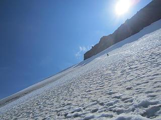 IMG_4382 IMG_4384 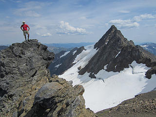 IMG_4391 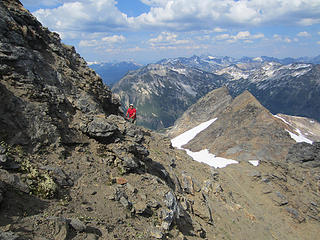 IMG_4393 IMG_4373 IMG_4396 IMG_4398 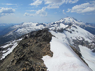 IMG_4400 IMG_4374 IMG_4407 IMG_4410 IMG_4413 IMG_4422 IMG_4429 IMG_4436 IMG_4439 IMG_4443 IMG_4445 IMG_4449 IMG_4450 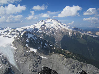 IMG_4455 IMG_4458 IMG_4462 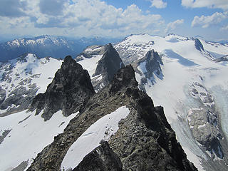 IMG_4464 IMG_4465 IMG_4466 IMG_4472 IMG_4480 IMG_4482 IMG_4485  IMG_4489 IMG_4491 IMG_4493 IMG_4496 IMG_4506 IMG_4510 IMG_4512 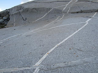 IMG_4516 IMG_4527 IMG_4539 IMG_4544 IMG_4545 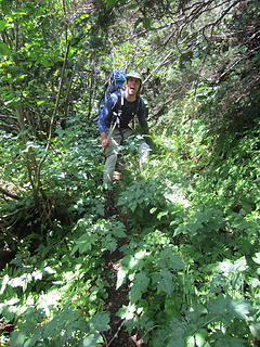 IMG_4548  IMG_4549 IMG_4551
|
| Back to top |
  
|
|
ree
Member

Joined: 29 Jun 2004
Posts: 4399 | TRs | Pics
|
|
ree
Member
|
 Tue Aug 13, 2013 4:20 pm |
|
|
What is 4472?
Amazing glaciers! Love that area.
|
| Back to top |
|
|
raising3hikers
Member

Joined: 21 Sep 2007
Posts: 2344 | TRs | Pics
Location: Edmonds, Wa |
Nice traverse you two, awesome pics  that is some nice glaciated area that is some nice glaciated area
|
| Back to top |
|
|
Bedivere
Why Do Witches Burn?

Joined: 25 Jul 2008
Posts: 7464 | TRs | Pics
Location: The Hermitage |
|
Bedivere
Why Do Witches Burn?
|
Tue Aug 13, 2013 6:58 pm |
|
|
Beautiful!
Ree- if i had to guess i'd say those are the goats.
|
| Back to top |
|
|
Tom_Sjolseth
Born Yesterday
Joined: 30 May 2007
Posts: 2652 | TRs | Pics
Location: Right here. |
Ree, that's just my sweet telephoto lens doing its magic (ie, trying to focus). Indeed, those are the goats. The herd was 40+ best that I could tell.
|
| Back to top |
|
|
gb
Member
Joined: 01 Jul 2010
Posts: 6310 | TRs | Pics
|
|
gb
Member
|
Wed Aug 14, 2013 7:29 am |
|
|
Tom,
Are you saying somebody has cut a new trail (or cleaned up the ancient one) into Thunder Basin?
|
| Back to top |
|
|
Jetlag
Member
Joined: 17 Aug 2010
Posts: 1410 | TRs | Pics
|
|
Jetlag
Member
|
Wed Aug 14, 2013 7:51 am |
|
|
Really enjoyed your Dakobed TR!!!
pic #4391 is excellent with the best view we saw of Luahna to the right of the climber on Chalangin ridge. After all your trips into this area (4?) what appears to be the best route up Luahna? The Richardson glacier still looks surprisingly solid.
#4413 - is that the camp with intense lightning above the Butterfly glacier? Do you know the name of the peak just to the right of Chalangin? We were impressed by its tusk-like pyramid and lack of any easy route.
#4462 - really like this photo from Tenpeak of the two lobes of the Honeycomb glacier. We found a spectacular pre-flattened camp at the head of the right lobe, just below the col that links the Honeycomb and Suiattle glaciers.
I also had the same question basically as gb - did the horsemen fix the two miles of White River trail from Boulder Creek to Thunder Basin, or did they go all the way up into Thunder Basin?
Thanks for the quick preparation of this awesome TR!
|
| Back to top |
|
|
DIYSteve
seeking hygge

Joined: 06 Mar 2007
Posts: 12655 | TRs | Pics
Location: here now |
|
DIYSteve
seeking hygge
|
Wed Aug 14, 2013 8:15 am |
|
|
Great stuff, Tom Very cool to see two TRs of adventurous Dakobed traverses on the same page!
|
| Back to top |
|
|
Tom_Sjolseth
Born Yesterday
Joined: 30 May 2007
Posts: 2652 | TRs | Pics
Location: Right here. |
Someone has gone in and brushed out the trail into Lower Thunder Basin with a team of horses. They did a really good job too, it was much easier to follow than when I was in there two years ago. They stopped at the big meadow before you go up through the slide alder next to the waterfall into the upper basins. I would guess it would be impossible to get a horse through that slide alder and subsequent steep forested slopes. The climber's path through the slide alder is difficult to follow, but there. Lots of chances to get into an epic brush battle here (reports in the summit register of it taking 3 hours to climb 600' in that area).
Jetlag.. the best route up Luahna is from the col that separates the Richardson from the Pilz. That would be the E Ridge. It's class 4 in one spot, but the rest is pretty easy scrambling. I think it took about 20 minutes to gain the summit from the col??
#4413 is the camp with the intense lightning. The peak to the right of Chalangin is unnamed (it doesn't have prominence) and could be considered just a point on the ridge. There are lots of neat features up there on that ridge, and that's definitely one of them!
I saw the camp in photo 4462 in your Dakobed TR. What a place to spend the night. I would like to have completed a traverse to N Fork Sauk (in fact, that was discussed), but the logistics of dropping cars would be a real pain. You guys had an awesome trip!
|
| Back to top |
|
|
HitTheTrail
Member

Joined: 30 Oct 2007
Posts: 5458 | TRs | Pics
Location: 509 |
Nice set of photos. Is that a pair of Salewa boots in pic #4466? If so what do you think of them? I have a pair of the Mt Trainer Mid GTX and have been trying to like them all summer, but the jury is still out.
|
| Back to top |
|
|
Jetlag
Member
Joined: 17 Aug 2010
Posts: 1410 | TRs | Pics
|
|
Jetlag
Member
|
Wed Aug 14, 2013 10:36 am |
|
|
Tom, thanks for the additional detail on routes, brush and camps. I can't figure out why it took me 43 years of Cascades hikes and climbs to discover this beautiful range and what it has to offer. Having your pictures and descriptions really sets me up for a 2nd encounter.
|
| Back to top |
|
|
Tom_Sjolseth
Born Yesterday
Joined: 30 May 2007
Posts: 2652 | TRs | Pics
Location: Right here. |
No kidding Jetlag.. this is one of the nicest areas in the range.. and so close!
HitTheTrail.. those are Salewa boots. I believe he likes them. Maybe Sergio can chime in.
|
| Back to top |
|
|
Jetlag
Member
Joined: 17 Aug 2010
Posts: 1410 | TRs | Pics
|
|
Jetlag
Member
|
Sat Aug 17, 2013 1:41 am |
|
|
Well . . . the Dakobed isn't so close to me down here near Mt. Rainier, but it's worth every mile of driving to get there. Just looking at Ree's pictures from her Kennedy Ridge ascent, I could see two of our best camps in the background and 8 of the glaciers we crossed. Looking at one of your pics, I was wondering if you crossed from Luahna to the Pilz glacier down that steep N/NW-facing snow and ice shield on Luahna.
|
| Back to top |
|
|
b00
Member

Joined: 29 Sep 2003
Posts: 1144 | TRs | Pics
|
|
b00
Member
|
Sat Aug 17, 2013 8:17 am |
|
|
|
| Back to top |
|
|
puzzlr
Mid Fork Rocks

Joined: 13 Feb 2007
Posts: 7220 | TRs | Pics
Location: Stuck in the middle |
|
puzzlr
Mid Fork Rocks
|
Sat Aug 17, 2013 12:07 pm |
|
|
Great trip, nice variation on the previous. Love to come across rocks like this
| Tom_Sjolseth wrote: | IMG_4516 |
|
| Back to top |
|
|
|
|


