| Previous :: Next Topic |
| Author |
Message |
Jason Hummel
Member


Joined: 31 Aug 2006
Posts: 1209 | TRs | Pics
Location: Tacoma Washington |
Curious about anyone's thoughts on this hike, and if they'd done some of the cross country sections. Most of these places I've been to, but it was when they were snow covered. I was thinking 4 days.
- Lake Lillian trailhead to Lake Lillian
- Lake Lillian cross country to Rampart Lakes
- Rampart Lakes to Lila Lake to Alta Pass to Park Lakes (mineral lakes Trail)
- Spectacle Lake to Glacier lake to Chikamin Lake
- Chikamin Lake up and over the shoulder of Chikamin down to the PCT
- Alaska Lake down to the Gold Creek Valley Trail
Any thoughts are appreciated. The one section I don't really know is Lila to Alta Pass to Park Lakes.
Thanks all.
|
| Back to top |
  
|
|
FiveNines
Member
Joined: 01 Oct 2010
Posts: 526 | TRs | Pics
|
Those are all really fun routes. I did a similar trip in 3 days a few years ago in late Aug. I could have used more time, but imagine I'm way slower than you'd be. I'd recommend going into Lillian via the backdoor, up Rocky Run. Think you'll have an easy time navigating over Alta Pass to Park Lakes.
I used D Inscho's tr for beta on the Alta Pass section.
https://www.nwhikers.net/forums/viewtopic.php?t=7987366
Followed his route pretty much exactly as described. I thought Tom or Dayhike Mike had a route description TR for this section, too, but I cannot find it right now.
|
| Back to top |
|
|
Joey
verrry senior member

Joined: 05 Jun 2005
Posts: 2798 | TRs | Pics
Location: Redmond |
|
Joey
verrry senior member
|
 Mon Aug 04, 2014 1:50 pm |
|
|
| Jason Hummel wrote: | | The one section I don't really know is Lila to Alta Pass to Park Lakes. |
You could try the old trail that went from Becky's Three Tarns up and over East Alta and then (I think) descended to Park Lakes. Years ago I did the part from the tarns to East Alta.
Below is a map where I traced near 3 sections of this old trail that are visible on the Google aerial if you zoom all the way in. I intentionally did not trace on top of the trail so you can see it.
From the tarns the trail traverses a talus field. When you get to a rock outcrop and would have to angle down to keep going, then the trail turns straight uphill in tight switchbacks. There may be little to no tread as you climb.
In due course you will come to a place where the tread is again visible and traverses to the right. IIRC, there might still be a large tree (blazed?) where the trail stops climbing and begins more traversing.
View larger size in new window
|
| Back to top |
|
|
Jason Hummel
Member
Joined: 31 Aug 2006
Posts: 1209 | TRs | Pics
Location: Tacoma Washington |
I appreciate the information Joey and Fivenines. Hopefully I'll head out on this in a day or two. I'll try and share some imagery, etc.
|
| Back to top |
|
|
contour5
Member

Joined: 16 Jul 2003
Posts: 2963 | TRs | Pics
|
|
contour5
Member
|
Mon Aug 04, 2014 11:22 pm |
|
|
The "Alta Pass" marked on the topos isn't really a used route. The old mountaineers climbing trail heads over the peak of East Alta, as shown in Joey's map. Sorta confusing...
The climber's trail continues, in a relatively level traverse all the way over to the Park/Glacier saddle, passing through the old horse camp high above Park Lakes.
Backdoor/ Rocky Run TH is a far quicker access to Lillian (compared to Mt Margaret/Twin Lakes)- but there's no permit box there- grab a card at Commonwealth or Snoq. Ranger hut if you wanna be legit.
Cross country between Spectacle and Glacier is very brushy- quicker and easier to use the PCT...although the gullies below Glacier are really nice- huge waterfalls from the tarns on PG saddle...the saddle is an awesome camp with an amazing view of Spectacle... lots of tarns...
At Lillian you can go either left or right around the lake- right is a bit quicker- the routes basically meet at the south end of Rampart Ridge. Some cool spots high on the ridge if you climb immediately where the 2 trails meet. Sorta cool camp if you take that hard right over the rock, when you arrive at Lillian...
Above Glacier the trail splits 3 ways- to Icebox Lake and the saddle between Chikamin and the 4Bros, to Chikamin Lake, or down to the wooded Lakes below the big falls. You can reach the PCT southbound by either of the first 2. I consider the first one easier...
Here's an old TR to add some confusion.
|
| Back to top |
|
|
H. Hound
Member

Joined: 09 May 2003
Posts: 1205 | TRs | Pics
Location: Exit 32 |
|
H. Hound
Member
|
Tue Aug 05, 2014 4:27 am |
|
|
| Quote: | | Spectacle Lake to Glacier lake to Chikamin Lake |
It's been a while, and I don't know what the water level in the creek will be like. When I did it, my feet stayed dry. I went up the creek connecting Glacier to Spectacle. When you hit a small waterfall go up the right side.
Glacier to Chickamin Lake - Go around the right side of the Monolith
From an old post
| H. Hound wrote: | 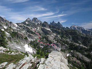 The route as best I remember it. Look at the "original size" and you will see the waterfall, you have to cross under. 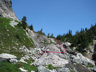 Another view of the water fall. The tricky junction is just past this area. 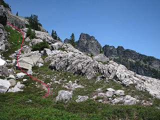 Tricky junction. The climbers path peels off to the left, just before here. The obvious trail goes down to the other drainage. The faint trail can be seen across the heather. 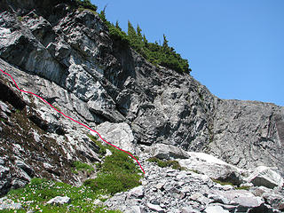 Shortly past the tricky junction you will hit this cliff. I went right first, and it goes nowhere good. Go up the ledges on the left. Not sure the pink line is in the correct spot on this one. |
|
| Back to top |
|
|
|
|


