| Previous :: Next Topic |
| Author |
Message |
Matt
Tea, Earl Grey, Hot


Joined: 30 Jan 2007
Posts: 4307 | TRs | Pics
Location: Shoreline |
|
Matt
Tea, Earl Grey, Hot
|
 Tue Aug 19, 2014 12:09 am |
|
|
Dicey & I camped on the high ridge between Tailgunner & Wing Peaks, and branched out to scramble those two peaks plus Gunnshy.
Highlights & Lowlights
Evil Hateful Bad: Getting off route in horrid steep brush on the Gunn Peak climbers track on the way in.
Wonderful: High camp on the ridge east of Tailgunner.
Poignant: Airplane debris so near the top of Wing Peak; the plane almost made it.
Relaxing: Swim for Matt and beer for Carla at camp between peaks.
Beautiful: Reflections in the Tailgunner tarn.
Smoky Fiery: Sunset views from Tailgunner.
Bright: Full moon after sunset.
Still Beautiful: Sunrise at the Tailgunner tarn.
Delightful: Acres of granite slabs on the high basin approaching Gunnshy.
Still Bad: Heat and deteriorated trail on the way back down the Gunn climbers track.
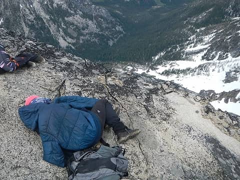
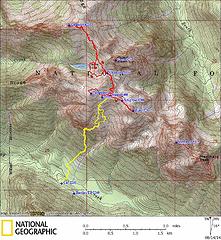 GPS Track (yellow lines are approach with packs, red lines are side trips to summits) 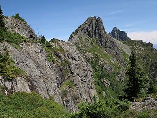 Somewhere on the way up, showing the steep terrain that that the trail has to work through to get onto the good ridge crest. 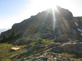 Camp on Tailgunner Ridge 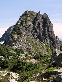 Wing Peak from Tailgunner Ridge 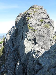 Wing Peak summit block route goes down around left side below the photo, then up the far left corner 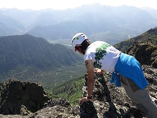 Carla looking over the edge at the Skykomish Valley 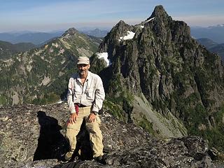 Me with the view to Townsend & Merchant Peaks 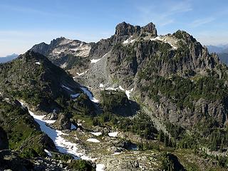 Gunnshy & Gunn Peaks 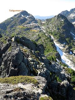 The ridge back to our camp and Tailgunner Peak 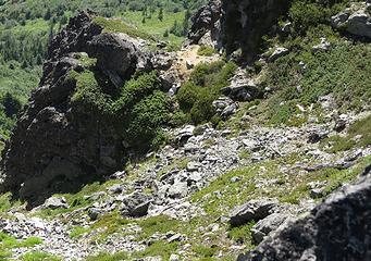 Airplane debris (hard to see in the sun glare, but pretty much everything that's not a square rock is pieces of aluminum) 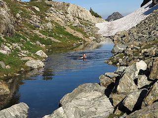 Swimming in the tarn below camp 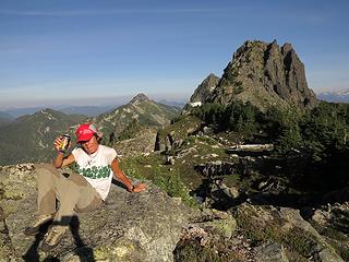 Beer on the rocks above camp 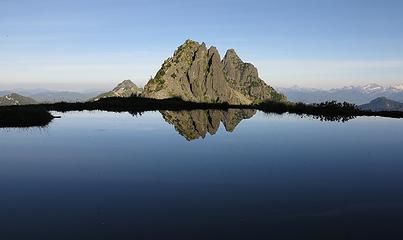 Wing & Merchant reflected in the Tailgunner Tarn 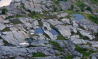 Tailgunner tarns from above 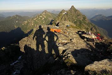 Tailgunner summit, 7:21pm 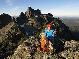 Carla with her beverage 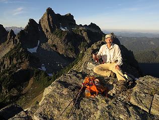 Me with my beverage 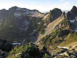 Gunnshy 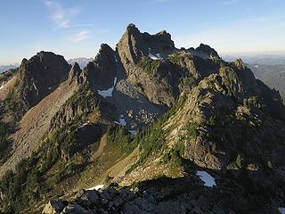 Gunn 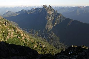 Baring & Barclay Lake 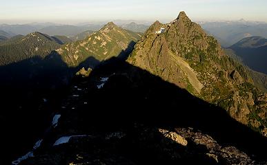 Shadows of Gunn & Tailgunner creeping across Burley, Townsend, and Wing/Merchant,7:41pm 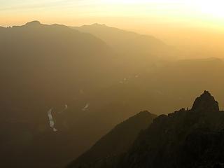 The Sky Valley 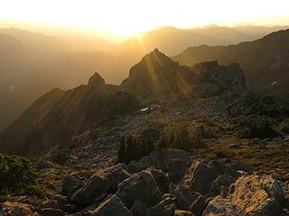 Sunbeams across pinnacles west of us 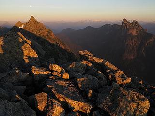 Merchant & Baring, 8:21pm 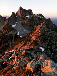 Gunn Alpenglow 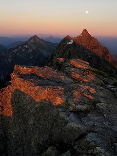 Merchant Alpenglow 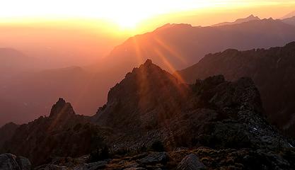 Sunset, 8:28pm 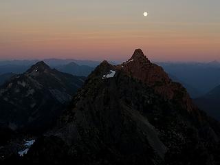 Moon over Merchant, 8:30pm 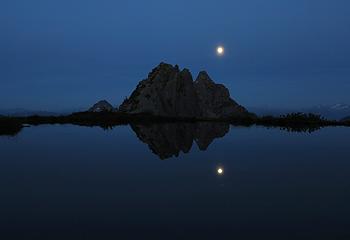 Late Reflection, 8:48pm 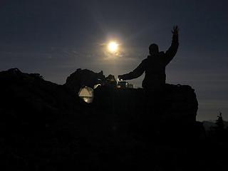 Moonlight shining through our various beverage containers 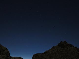 Big Dipper over Northeast Tailgunner (Point 5760), 9:45pm 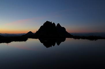 Foreglow in the Tailgunner Tarn, 5:37am 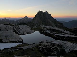 Another tarn at sunrise, 6:02am 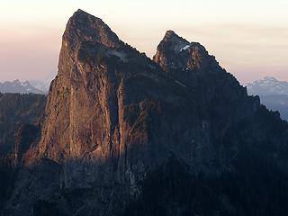 Early light on the north face of Baring 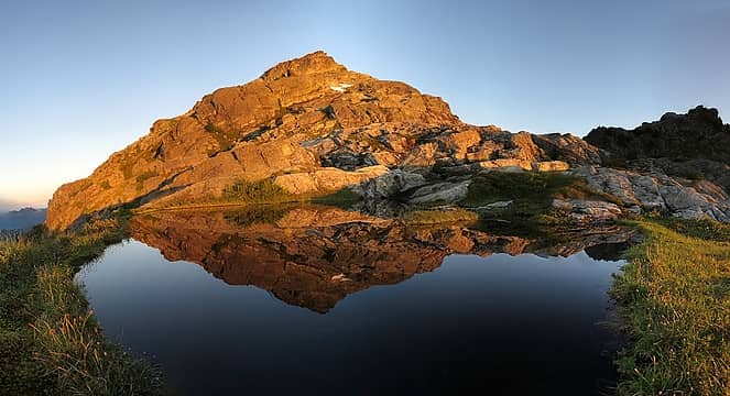 Tailgunner Sunrise Reflection, 6:09am 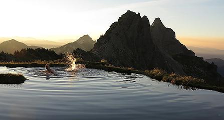 Swimming in the morning glow 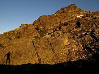 Morning shadow drying off in the warm air 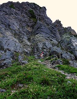 Descending into the Gunnshy basin 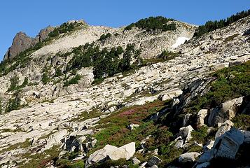 Glorious fields of granite and heather ahead of us 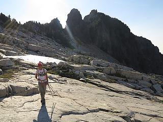 Carla walking the acres of slabs of Gunnshy basin 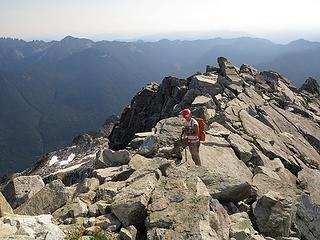 Carla on the crest below Gunnshy summit 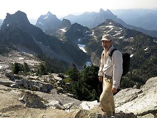 Me near Gunnshy summit 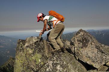 Carla braving swarms of flying ants to fetch the register 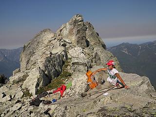 Relaxing away from the ants 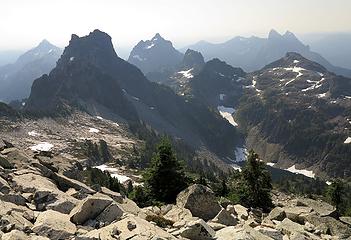 7 labels The local cluster of peaks: Townsend, Gunn, Merchant, Wing, Grotto, Baring, Tailgunner 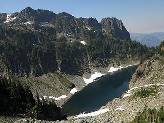 Descending to Gunn Lake 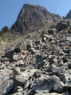 More boulder-scrambling on the way down 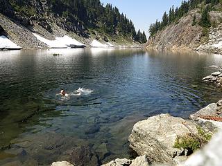 Swimming in Gunn Lake 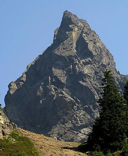 On the way back up, steep end of Gun with mountain goats at the col
As beacons mountains burned at evening. J.R.R. Tolkien
As beacons mountains burned at evening. J.R.R. Tolkien
|
| Back to top |
  
|
|
b00
Member

Joined: 29 Sep 2003
Posts: 1144 | TRs | Pics
|
|
b00
Member
|
Tue Aug 19, 2014 7:19 am |
|
|
|
| Back to top |
|
|
BarbE
Member

Joined: 28 Jul 2006
Posts: 1153 | TRs | Pics
|
|
BarbE
Member
|
Tue Aug 19, 2014 8:19 am |
|
|
|
| Back to top |
|
|
iron
Member

Joined: 10 Aug 2008
Posts: 6392 | TRs | Pics
Location: southeast kootenays |
|
iron
Member
|
Tue Aug 19, 2014 8:52 am |
|
|
ant orgies are never fun.
|
| Back to top |
|
|
Stefan-K
Member

Joined: 10 Aug 2009
Posts: 522 | TRs | Pics
Location: seattle |
|
Stefan-K
Member
|
Tue Aug 19, 2014 11:00 am |
|
|
ha, fern field - -
that annual cycle of lush growth is totally worth getting off route in my humble opinion...
great pics!
love that area
|
| Back to top |
|
|
Riverside Laker
Member

Joined: 12 Jan 2004
Posts: 2818 | TRs | Pics
|
Are the berries ripening yet? Best berries I've ever found up there!
|
| Back to top |
|
|
Matt
Tea, Earl Grey, Hot
Joined: 30 Jan 2007
Posts: 4307 | TRs | Pics
Location: Shoreline |
|
Matt
Tea, Earl Grey, Hot
|
Tue Aug 19, 2014 11:30 am |
|
|
I also found great crops of berries there on a previous trip a bit later in August.
This time they were still a few weeks early. We found occasional ripe berries, but only in the warmest south-facing slopes.
As beacons mountains burned at evening. J.R.R. Tolkien
As beacons mountains burned at evening. J.R.R. Tolkien
|
| Back to top |
|
|
Redwic
Unlisted Free Agent

Joined: 23 Feb 2009
Posts: 3292 | TRs | Pics
Location: Going to the Prom(inence) |
|
Redwic
Unlisted Free Agent
|
Tue Aug 19, 2014 12:19 pm |
|
|
60 pounds lighter but not 60 points brighter.
|
| Back to top |
|
|
filbert
Member

Joined: 31 May 2010
Posts: 99 | TRs | Pics
|
|
filbert
Member
|
Tue Aug 19, 2014 12:32 pm |
|
|
Beautiful! Gotta find time for this one.
With every passing hour our solar system comes forty-three thousand miles closer to globular cluster M13 in the constellation Hercules, and still there are some misfits who continue to insist that there is no such thing as progress.
With every passing hour our solar system comes forty-three thousand miles closer to globular cluster M13 in the constellation Hercules, and still there are some misfits who continue to insist that there is no such thing as progress.
|
| Back to top |
|
|
Stefan
Member

Joined: 17 Dec 2001
Posts: 5093 | TRs | Pics
|
|
Stefan
Member
|
Tue Aug 19, 2014 1:27 pm |
|
|
Those are some beautiful pictures. Well done! Looks like fun!
|
| Back to top |
|
|
contour5
Member

Joined: 16 Jul 2003
Posts: 2963 | TRs | Pics
|
|
contour5
Member
|
Tue Aug 19, 2014 4:40 pm |
|
|
Looks really nice up there.
|
| Back to top |
|
|
cartman
Member
Joined: 20 Feb 2007
Posts: 2800 | TRs | Pics
Location: Fremont |
|
cartman
Member
|
Tue Aug 19, 2014 9:53 pm |
|
|
Man, did you score on those tarn shots--perfect reflections. Very nice.
That Gunn trip was last weekend Aug 2005, another beautiful day up there. Great berries.
|
| Back to top |
|
|
Magellan
Brutally Handsome

Joined: 26 Jul 2006
Posts: 13116 | TRs | Pics
Location: Inexorable descent |
|
Magellan
Brutally Handsome
|
Tue Aug 19, 2014 11:18 pm |
|
|
Lovely story and pictures, Matt. 
|
| Back to top |
|
|
Michael Lewis
Taking a nap
Joined: 27 Apr 2009
Posts: 629 | TRs | Pics
Location: Lynnwood, WA (for now) |
| Quote: | Moonlight shining through our various beverage containers |
would you call that, moon shine?  Beautiful photos. I like the tarns especially. Someday maybe I'll get the guts to go up there.
|
| Back to top |
|
|
puzzlr
Mid Fork Rocks

Joined: 13 Feb 2007
Posts: 7220 | TRs | Pics
Location: Stuck in the middle |
|
puzzlr
Mid Fork Rocks
|
Wed Aug 20, 2014 12:36 am |
|
|
I can't believe you ended up in the middle of that horrid basin. It was bad just looking at it from above and imagining ...
Your pictures are so great we should make a calendar just from this trip. I love those rocky meadows on the ridge around Gunn.
|
| Back to top |
|
|
|
|
You cannot post new topics in this forum
You cannot reply to topics in this forum
You cannot edit your posts in this forum
You cannot delete your posts in this forum
You cannot vote in polls in this forum
|
Disclosure: As an Amazon Associate NWHikers.net earns from qualifying purchases when you use our link(s). |


