| Previous :: Next Topic |
| Author |
Message |
tinytowers
Member


Joined: 28 Nov 2011
Posts: 69 | TRs | Pics
|
With summer-like weather on the horizon, I called up my buddy Mark, and we made our way up to the Selkirks for a drop down into the Kent Lake cirque. Id been up on Kent Ridge the week before exploring possible routes to the lake and the cabin, and came away with a couple of options; neither of them easy.
Ive been meaning to get to the lake for quite some time after finding out about a secret, hush-hush cabin located on its northern shore. The cabin is privately owned and the land somehow acquired in a land exchange some forty years ago. The owner has chosen to leave it unlocked, as long as the cabin is treated with respect and replenished with any supplies used. It is fully stocked with food, a first aid kit and expired powdered milk, but I recommend bringing your own stash and maybe an extra candle or two. Its recommended you call the owner beforehand to arrange your stay. This might also help you to avoid sharing the cabin with other parties. The owners name is Gary Miller, and his phone number is 509.248.7398.
After reading through the guestbook it became apparent that the cabin is more of a winter destination. Most of the entries were from snowmobilers and back-country skiers looking for a snowy escape into the Kirks. One skier had written about a midnight romp to the cabin from Long Canyon Ridge under a full moon, but it seems most people skin their way up to Kent Peak and bomb back down the cabin below. Winter access is through Lions Creek drainage, but I wouldnt recommend this route in the summer or fall, unless brush bashing is your thing.
The lake itself is stunning and the 1500 granite cirque its cradled by is absolutely incredible. However, I was a bit disappointed with the weedy shoreline and lack of fish. If youre looking to spend some time on the lake, there are some really nice granite slabs on the southwest end, one large enough to pitch a tent on.
To get to the trailhead, head north on I-95 out of Sandpoint and turn west into Naples. Bear right on Deep Creek Rd (Old Hwy 2). Continue north 5.7 miles and turn left toward Snow Creek Road. Drive 2 miles to a Y and take the gravel road to the left (FR 402). Take this road for about 18 miles to the trailhead. *IMPORTANT* When you reach the signs for Bottleneck Lake and Roman Nose Lakes, take a hard right switchback turn onto FR 661 (might also be labeled 633 on the map)
Take the Two Mouth trail up roughly 3-4 miles to a junction in the trail and the beginning of the ridge heading west toward the Kent Lake area. After this, its all off-trail scrambling. Once you've reached the Kent Peak/Wigwam saddle junction, look for a somewhat grassy area below and start your descent.
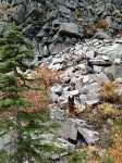
Theres no easy way down, and the route requires some major boulder hopping through massive talus fields.
|
| Back to top |
  
|
|
Treehugger5
Member
Joined: 23 Sep 2012
Posts: 407 | TRs | Pics
Location: Spokane, WA |
Cool TR. Sounds like a great trip-- until the coming back up part.  What do you estimate total mileage to be?
Elrond's Rocket of Rivendell~ hiker and runner extraordinaire
Elrond's Rocket of Rivendell~ hiker and runner extraordinaire
|
| Back to top |
|
|
tinytowers
Member
Joined: 28 Nov 2011
Posts: 69 | TRs | Pics
|
Thanks, it was a good one.
Total mileage round trip would be about 15 miles and maybe 5k gain. Keep in mind that 60-70% of that is off-trail scrambling. It's totally doable. I could probably do it in a day, but I don't see the point.
Make it to the Selkirk's much? Always looking for company.
|
| Back to top |
|
|
Redwic
Unlisted Free Agent

Joined: 23 Feb 2009
Posts: 3292 | TRs | Pics
Location: Going to the Prom(inence) |
|
Redwic
Unlisted Free Agent
|
 Fri Sep 26, 2014 5:16 am |
|
|
60 pounds lighter but not 60 points brighter.
|
| Back to top |
|
|
Backpacker Joe
Blind Hiker

Joined: 16 Dec 2001
Posts: 23956 | TRs | Pics
Location: Cle Elum |
Thats awesome. Thanks for the beta. 
"If destruction be our lot we must ourselves be its author and finisher. As a nation of freemen we must live through all time or die by suicide."
Abraham Lincoln
"If destruction be our lot we must ourselves be its author and finisher. As a nation of freemen we must live through all time or die by suicide."
Abraham Lincoln
|
| Back to top |
|
|
tinytowers
Member
Joined: 28 Nov 2011
Posts: 69 | TRs | Pics
|
LST is a favorite Selkirk destination of mine. I'd go late in the year if I were you. Still need to summit its bigger brother.
|
| Back to top |
|
|
Chief Joseph
Member

Joined: 10 Nov 2007
Posts: 7701 | TRs | Pics
Location: Verlot-Priest Lake |
I really like that area and i really like TR's that actually give you the info needed to actually find the TH and take the hike, thanks!
Go placidly amid the noise and waste, and remember what comfort there may be in owning a piece thereof.
Go placidly amid the noise and waste, and remember what comfort there may be in owning a piece thereof.
|
| Back to top |
|
|
Dubeman44
Member
Joined: 08 May 2015
Posts: 2 | TRs | Pics
|
this hike is completely worthwhile me and five of my buddies checked it out last summer right before you were there actually super cool journey super rewarding super hard though took us 11 hours to get from the trailhead at wigwams to the cabin hiked out going towards lions head and the waterslides camped at the top of the slides hike out the next day total of 5 days up there. planning on camping at the first stream you come to going up wigwams and spending a day on the ridgeline next. the hike out towards the water slides was extremely hard as you mentioned lots of bushwhacking we tried to go up that way to Kentlake the previous summer but didn't plan for it accordingly the only way to go up that way in my eyes is to camp at that main campsite at the top of the water slides and then have a fresh start in the morning to bushwhack through to the lake both ways no matter how you look at it or hard traversing the ridgeline means that you have to deal with all of that vertical gain and descent but going up from the other side means you have to bushwhack I might try going up the stream sometime but waders would be necessary
|
| Back to top |
|
|
Shelby
Member
Joined: 14 Jun 2016
Posts: 1 | TRs | Pics
Location: Spokane |
|
Shelby
Member
|
Tue Jun 14, 2016 11:47 am |
|
|
I was wondering if anyone could provide a few more details about the trail to get from the Wigwam summit to Kent lake? I'm trying to organize an overnight hike for a group of Whitworth University students and would love more details to be able to provide them with. What is the terrain like? Is there a clear path? Are there stream crossings? Is this a doable overnight trip if they stay at Kent lake? Are there any campsites at the lake or just the cabin? Thank you in advance for any answers!
|
| Back to top |
|
|
Dubeman44
Member
Joined: 08 May 2015
Posts: 2 | TRs | Pics
|
The hike from the parking area up wigwams is not bad at all. About 10 min in, u will come to a nice campsite by a little stream. If you camped there and hiked back towards the Stream see a Boulder Field that you can climb most of the way up to the closest Peak it only took me and my dog 20 minutes. From the campsite it's a short hike to the base of the switchbacks that lead up wigwams. The switchbacks were really brutal on our party due to the fact that we were all carrying 50 and 60 pound packs with us. Once you're at the top you will have to navigate around the Peaks which was a little scary but worth it when you come around the other side to the Ridgeline. I did not notice any established Trail along the Ridgeline that we were following. There is a section after you get to the end of that first Ridge where you will have to drop down and then back up on the other side of a saddle sort of. It looks safe enough to cross straight across without dropping down and requiring you to climb back up however half of our group opted for the high road and the other half opted for the low road. The high road proved to be much more difficult than we anticipated however through careful attention and focus on what we were doing we safely made it across the safer route is definitely the low road though. After that you are basically on the ridge leading down into the bowl of Kent Lake. You kind of want to stay along the edge of the tree line as much as you can on the way down but after doing it and experiencing the thick brush and steep descent going down there and looking at the map it looks like it might have been easier to try and Boulder hop our way down the large Boulder Field. From there you've made it to Kent Lake there is what looks like a potential campsite on a large granite slab on one side of the lake opposite the cabin. Good luck navigating out from there we hiked our way out towards Lions head Lions head. The terrain there is very thick we had to bushwhack a significant amount you begin by following a trail out from kentlake and it looks like you start to climb up a good ways that's where we think we may have gone wrong but we ended up having to bushwhack a significant way through to find the campsite at the top of lions head there are I think 3 stream Crossings but there may be for before you get to that campsite but from there on out the trail is easily accessible and well-marked
|
| Back to top |
|
|
tinytowers
Member
Joined: 28 Nov 2011
Posts: 69 | TRs | Pics
|
Finally made it in to cabin in winter, and I must say the line from the Kent Peak summit down to the cabin is pure epicness. Such a sick zone.
|
| Back to top |
|
|
Dirt_junky208
Member
Joined: 09 Apr 2019
Posts: 3 | TRs | Pics
Location: Selkirks |
Ive had this TR bookmarked for ages! Finally made it down to the lake last weekend. I parked at Harrison lake trailhead, climbed the rock beehive, traversed under the crest to Harrison lake, then traversed the west face of Harrison peak to the ridge leading down into two mouth basin where I stayed the night. Then headed northwest up the ridge and gained Kent peak before dropping into the lake for a swim. Followed trail east then climbed the east bowl to the ridge south of myrtle peak where I stayed a second night. From there I headed south back to two mouth then followed the ridge of Myrtles turtle to the east face of Harrison then trail down to TH.
|
| Back to top |
|
|
drv8535
Darrick
Joined: 06 Apr 2019
Posts: 19 | TRs | Pics
Location: Spokane |
|
drv8535
Darrick
|
Thu Apr 01, 2021 1:01 pm |
|
|
Hey Dirt_junky, your response about your trip is super intriguing as something I'd like to attempt, too! I've got 3 questions for you, if you can remember from 2 years ago. 1) Your post is from July 3rd - is that about the time you attempted this, and if so, how was the snow line by then? 2) Can you (or anyone) point out Myrtle's Turtle on a map? - I've heard it referenced in other trip reports and I'm not sure where this geographic location/feature is... 3) Do you have an actual trip report posted somewhere?
Cheers!
|
| Back to top |
|
|
Dirt_junky208
Member
Joined: 09 Apr 2019
Posts: 3 | TRs | Pics
Location: Selkirks |
Yea it was first of July, two years ago but last year the same time period there was still quite a bit of snow. Myrtles turtle is just east of two mouth lakes and is visible from two mouth trail head. You can do a shorter version of this from two mouth.
|
| Back to top |
|
|
|
|


