| Previous :: Next Topic |
| Author |
Message |
Gimpilator
infinity/21M


Joined: 12 Oct 2006
Posts: 1684 | TRs | Pics
Location: Edmonds, WA |
Picacho del Diablo (Peak of the Devil) is the highest point of Baja Mexico and is considered the toughest ascent on the Sierra Club Desert Peaks Section list. The terrain is rugged, steep and route finding is difficult. The standard route drops down 3000 feet into a rocky canyon before climbing back up to reach the summit. Success rates are relatively low.
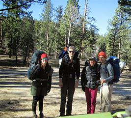 trailhead 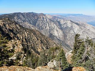 observatory telescope (visible upper left) 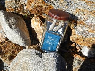 Blue Bottle summit register 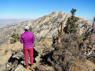 Heather scoping the peak 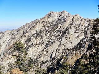 Peak of the Devil 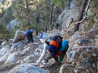 descending 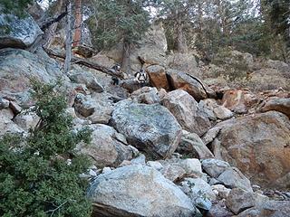 rough terrain 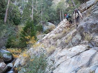 sketchy slab traverse 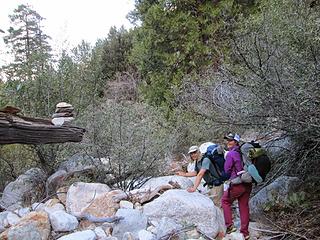 photo by Greg Slayden 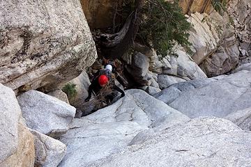 4th class spot  So much for making a video. Jill was generous enough to offer to loan me her camera to document the rest of the trip.
the large brush choked gully
We descended slightly into the big gully and the followed cairns up along the right side. We lost the route briefly by ascending too high along the right side. Descending 40 feet put us right back on track. The cairns led us into the middle where there were a few 4th class crux moves up slabs and rock steps. Then along the left side of the gully we came to the base of the dihedral friction slabs. So much for making a video. Jill was generous enough to offer to loan me her camera to document the rest of the trip.
the large brush choked gully
We descended slightly into the big gully and the followed cairns up along the right side. We lost the route briefly by ascending too high along the right side. Descending 40 feet put us right back on track. The cairns led us into the middle where there were a few 4th class crux moves up slabs and rock steps. Then along the left side of the gully we came to the base of the dihedral friction slabs.
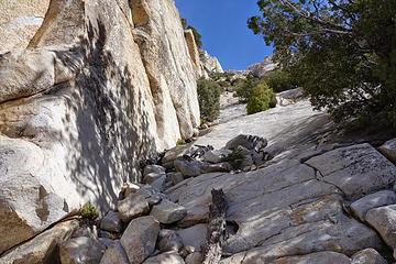 dihedral friction slabs 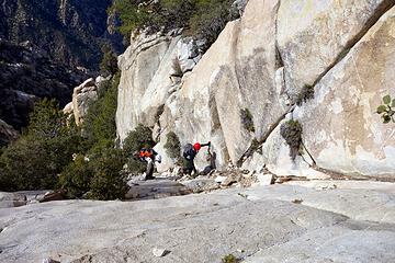 dihedral friction slabs 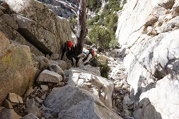 chockstone bypass ledge in Wall Street 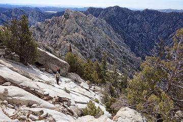 near the summit  We couldn't quite see the Pacific Ocean as it was somewhat hazy on that side. We couldn't quite see the Pacific Ocean as it was somewhat hazy on that side.
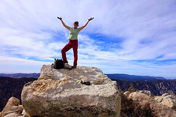 Heather on the summit 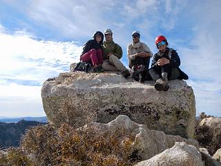 summit 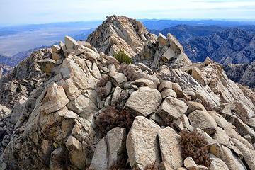 the south summit only slightly lower 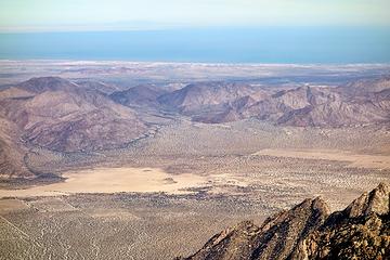 Sea of Cortez  One of the most amazing and graceful creatures I have ever seen in the wild. It was circling around us on the edges of camp, obviously attracted by the smell of our food. I tried in vain to photograph it, but the flash delay on my camera caused me to miss the shot. One of the most amazing and graceful creatures I have ever seen in the wild. It was circling around us on the edges of camp, obviously attracted by the smell of our food. I tried in vain to photograph it, but the flash delay on my camera caused me to miss the shot.
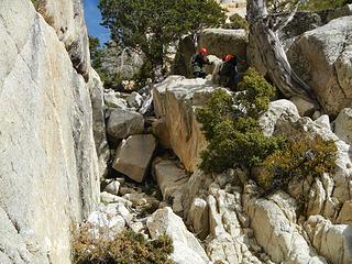 descending the chockstone slot ledge 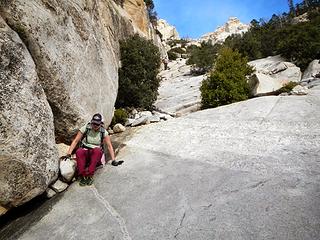 back at Wall Street
|
| Back to top |
  
|
|
Paul M
Member

Joined: 15 Jul 2008
Posts: 371 | TRs | Pics
|
|
Paul M
Member
|
 Sun Nov 30, 2014 6:50 pm |
|
|
Nice trip Adam. Looks like you are making great use of your time down south.
|
| Back to top |
|
|
MtnGoat
Member

Joined: 17 Dec 2001
Posts: 11992 | TRs | Pics
Location: Lyle, WA |
|
MtnGoat
Member
|
Sun Nov 30, 2014 8:53 pm |
|
|
Man that looks dry. Did you haul all your water for the better part of three days?
Diplomacy is the art of saying 'Nice doggie' until you can find a rock. - Will Rogers
Diplomacy is the art of saying 'Nice doggie' until you can find a rock. - Will Rogers
|
| Back to top |
|
|
Redwic
Unlisted Free Agent

Joined: 23 Feb 2009
Posts: 3292 | TRs | Pics
Location: Going to the Prom(inence) |
|
Redwic
Unlisted Free Agent
|
Mon Dec 01, 2014 8:09 am |
|
|
60 pounds lighter but not 60 points brighter.
|
| Back to top |
|
|
Gimpilator
infinity/21M
Joined: 12 Oct 2006
Posts: 1684 | TRs | Pics
Location: Edmonds, WA |
It was extremely dry. However there is plenty of water in the stream at camp noche, so we only carried a days worth at a time.
|
| Back to top |
|
|
Ski
><((((°>

Joined: 28 May 2005
Posts: 12831 | TRs | Pics
Location: tacoma |
|
Ski
><((((°>
|
Mon Dec 01, 2014 12:39 pm |
|
|
excellent! 
"I shall wear white flannel trousers, and walk upon the beach.
I have heard the mermaids singing, each to each."
"I shall wear white flannel trousers, and walk upon the beach.
I have heard the mermaids singing, each to each."
|
| Back to top |
|
|
puzzlr
Mid Fork Rocks

Joined: 13 Feb 2007
Posts: 7220 | TRs | Pics
Location: Stuck in the middle |
|
puzzlr
Mid Fork Rocks
|
Mon Dec 01, 2014 10:17 pm |
|
|
That is a really interesting trip report. Surely a peak that few around here have done. It looked like Wall Street might be really bad for rock fall because of funneling onto the climbing route. But maybe that's just the pictures. Anyway, very cool peak and thanks for the report.
|
| Back to top |
|
|
Bernardo
Member

Joined: 08 Feb 2010
Posts: 2174 | TRs | Pics
Location: out and about in the world |
|
Bernardo
Member
|
Tue Dec 02, 2014 9:31 pm |
|
|
Another great destination in Mexico. Very nice. I recently enjoyed reading your "10 days in Mexico" report on summitpost in preparation for some possible future trips.
|
| Back to top |
|
|
|
|
You cannot post new topics in this forum
You cannot reply to topics in this forum
You cannot edit your posts in this forum
You cannot delete your posts in this forum
You cannot vote in polls in this forum
|
Disclosure: As an Amazon Associate NWHikers.net earns from qualifying purchases when you use our link(s). |


