| Previous :: Next Topic |
| Author |
Message |
puzzlr
Mid Fork Rocks


Joined: 13 Feb 2007
Posts: 7220 | TRs | Pics
Location: Stuck in the middle |
|
puzzlr
Mid Fork Rocks
|
 Mon Jan 05, 2015 8:08 pm |
|
|
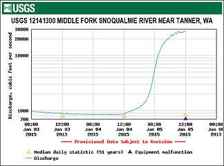
The warm rain storm on January 4 and 5 resulted in near record flows on the Middle Fork river. Heavy rain on the morning of January 5 caused several creeks to overflow the road with the worst being the creek crossing at MP 9.9 just past the CCC road intersection. The Middle Fork road is closed at Valley Camp (MP 2.2) and I walked in from there to get these photos, and later got a ride with some ACI road construction employees out to check on the condition of the water passages. The road will probably be closed for a while because significant repairs are needed at the MP 9.9 creek crossing.
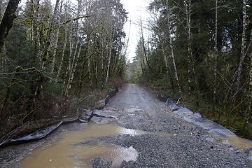
 TANW1 graph 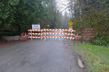 Road closed at Valley Camp - In general there must have been very little wind activity because the road is very clear. One tree fell at the RR pilings at MP 7.5 but it has been cut so a vehicle can pass.
- There is a small washout in rocks above the first close river bend approach (Island Drop) at MP 3.4.
- The creek at MP 6.8 (Wise Creek) was overflowing the road in the morning and is what caused the road to be closed. By the time I was there the creek was down and flowing well through the culvert with minimal road damage.
 MP 6.8 creek - The creek at MP 9.9 is the one with the two new water crossings. The second one is fine, but the first one plugged up with debris and is overflowing the road causing significant damage. Some of the concrete slabs are undercut and even when the water goes down will be dangerous to cross. This will probably keep the road closed until some cleanup and repairs are made.
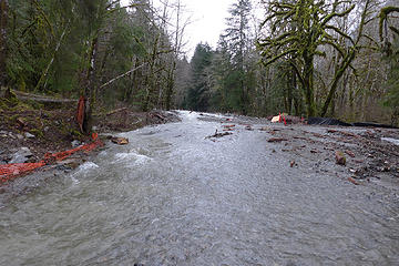 MP 9.9 creek overflowing the road because rock and tree debris completely blocked the first new water passage structure. This creek is located just beyond where the CCC road/trail intersects the Middle Fork road. 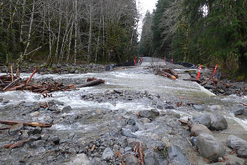 MP 9.9 creek  MP 9.9 creek 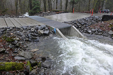 Functioning water crossing on 11/25/2014 - The two new bridges at MP 8.1 (Big Blowout creek) and MP 10.6 (station 588) are both fine
- Beyond the MP 10.6 bridge a party returning from Goldmyer reported that the paved section has no problems. They said there are two washouts between the Taylor River bridge and Dingford Creek. On Sunday night one was running deep enough to cause them to camp overnight instead of trying to cross it. On Monday morning they said it was possible to cross in the their 4x4 jeep, but probably requires a high clearance vehicle of some sort.
More photos on flickr. A sample:
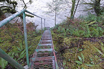 Water boiling just below the stairs at TANW1 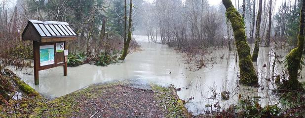 Middle Fork river up to the sign at the concrete bridge access point 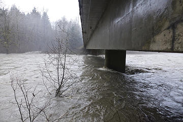 Concrete bridge pillars
|
| Back to top |
  
|
|
iron
Member

Joined: 10 Aug 2008
Posts: 6392 | TRs | Pics
Location: southeast kootenays |
|
iron
Member
|
Mon Jan 05, 2015 8:59 pm |
|
|
thanks for the update MFK historian.
seems like a poor design if the culvert already failed. grr...
|
| Back to top |
|
|
puzzlr
Mid Fork Rocks
Joined: 13 Feb 2007
Posts: 7220 | TRs | Pics
Location: Stuck in the middle |
|
puzzlr
Mid Fork Rocks
|
Mon Jan 05, 2015 9:13 pm |
|
|
I'm not a road engineer but I'll be a little slower to blame poor design here. That creek is in the process of re-establishing slope equilibrium after a huge rock fall into the creek bed upstream ~10 years ago. The "bulge" of debris first washed onto the road in the 2009 flood and this is the second time it's moved. The amount of material that piled up around the intake of the culvert is huge. The design anticipated some events like this and allows for rocks to be bulldozed off the concrete slabs, but I think the magnitude of this is surprising and somewhat rare. It's possible that once they clear the debris it won't be as bad as it seems right now. Unfortunately, all the construction equipment has left the valley for the winter and I don't know who has to come up with money to fix it. That argument may cause extra delays. It's on USFS land so the interested parties will be the USFS, King County (who maintains the road, but maybe not this far up), and the construction firm ACI.
|
| Back to top |
|
|
Bernardo
Member

Joined: 08 Feb 2010
Posts: 2174 | TRs | Pics
Location: out and about in the world |
|
Bernardo
Member
|
Mon Jan 05, 2015 9:25 pm |
|
|
Interesting. Thanks for posting. Won't be able to check this out myself for a while.
Looks like that slab crossing may have been designed to be quickly repaired at reasonable cost.
The river flow chart indicates equipment failure. I wonder what happened there.
|
| Back to top |
|
|
zephyr
aka friendly hiker

Joined: 21 Jun 2009
Posts: 3370 | TRs | Pics
Location: West Seattle |
|
zephyr
aka friendly hiker
|
Mon Jan 05, 2015 9:32 pm |
|
|
Whoa... Thanks, puzzlr for scouting this out for us and posting the report and photos. Very informative. Great photos. ~z
|
| Back to top |
|
|
Magellan
Brutally Handsome

Joined: 26 Jul 2006
Posts: 13116 | TRs | Pics
Location: Inexorable descent |
|
Magellan
Brutally Handsome
|
Mon Jan 05, 2015 10:16 pm |
|
|
|
| Back to top |
|
|
wolffie
Member

Joined: 14 Jul 2008
Posts: 2693 | TRs | Pics
Location: Seattle |
|
wolffie
Member
|
Mon Jan 05, 2015 10:37 pm |
|
|
I wonder if it's even possible to build roads in these mountains that will last long without constant maintenance. We have a long, long history of being surprised by what happens to our stuff.
Something interesting up the Pratt River on the old logging RR grade: there's a culvert that has NOT washed out, and it might date to the '30s.
Thanks for the disappointing info; it beats learning the hard way.
Some people have better things to do with their lives than walking the dog. Some don't.
Some people have better things to do with their lives than walking the dog. Some don't.
|
| Back to top |
|
|
Sore Feet
Member

Joined: 16 Dec 2001
Posts: 6307 | TRs | Pics
Location: Out There, Somewhere |
| puzzlr wrote: | | The creek at MP 6.8 (Wise Creek) was overflowing the road in the morning and is what caused the road to be closed. |
 This blows my mind - that creek is normally a solid 10+ feet below the road bed and while I've seen it swollen pretty good, I never even imagined it could get anywhere close to over topping the road. It must have been absolutely pouring up there for this to happen.
|
| Back to top |
|
|
Kascadia
Member

Joined: 03 Feb 2014
Posts: 651 | TRs | Pics
|
|
Kascadia
Member
|
Mon Jan 05, 2015 11:27 pm |
|
|
I heard from someone that lives up in that area that the north fork is (was) running higher than they'd seen in 25 years and caused some unexpected difficulties in travel.
It is as though I had read a divine text, written into the world itself, not with letters but rather with essential objects, saying:
Man, stretch thy reason hither, so thou mayest comprehend these things. Johannes Kepler
It is as though I had read a divine text, written into the world itself, not with letters but rather with essential objects, saying:
Man, stretch thy reason hither, so thou mayest comprehend these things. Johannes Kepler
|
| Back to top |
|
|
touron
Member

Joined: 15 Sep 2003
Posts: 10293 | TRs | Pics
Location: Plymouth Rock |
|
touron
Member
|
Mon Jan 05, 2015 11:30 pm |
|
|
It might be good to get a couple of once in a century type storms before they finish paving the road. 
Touron is a nougat of Arabic origin made with almonds and honey or sugar, without which it would just not be Christmas in Spain.
Touron is a nougat of Arabic origin made with almonds and honey or sugar, without which it would just not be Christmas in Spain.
|
| Back to top |
|
|
RichP
Member

Joined: 13 Jul 2006
Posts: 5634 | TRs | Pics
Location: here |
|
RichP
Member
|
Tue Jan 06, 2015 6:26 am |
|
|
Very interesting. The Middle Fork will always win.
|
| Back to top |
|
|
coldrain108
Thundering Herd

Joined: 05 Aug 2010
Posts: 1858 | TRs | Pics
Location: somewhere over the rainbow |
| touron wrote: | | a couple of once in a century type storms |
that happen every 5 years...is that the new math?
Since I have no expectations of forgiveness, I don't do it in the first place. That loop hole needs to be closed to everyone.
Since I have no expectations of forgiveness, I don't do it in the first place. That loop hole needs to be closed to everyone.
|
| Back to top |
|
|
Windstorm
Member
Joined: 16 Dec 2014
Posts: 288 | TRs | Pics
|
| coldrain108 wrote: | | touron wrote: | | a couple of once in a century type storms |
that happen every 5 years...is that the new math? |
Actually, the "100-year storm" isn't one that's expected once every hundred years. It's a storm that has a 1% chance (1 in 100) of happening in any given year. If I remember from my probability and statistics class, the probability of the storm occurring one year would be independent of the probability the next year. If we've had a couple of big storms within a few years, it just means we beat the odds.
"New math" is something I never learned. However, I do find probability and statistics to be counterintuitive and I have the equivalent of a math minor.
|
| Back to top |
|
|
Kascadia
Member
Joined: 03 Feb 2014
Posts: 651 | TRs | Pics
|
|
Kascadia
Member
|
Tue Jan 06, 2015 11:51 am |
|
|
Well I'm no weather expert, but I'm not sure rolling the dice (same independent probability each time) and long term weather patterns are an "equal" starting point in terms of comparing probabilty. There are long term cyclic weather patterns that influence weather over a period of time as I understand the process. But I am open to facts. . . . 
It is as though I had read a divine text, written into the world itself, not with letters but rather with essential objects, saying:
Man, stretch thy reason hither, so thou mayest comprehend these things. Johannes Kepler
It is as though I had read a divine text, written into the world itself, not with letters but rather with essential objects, saying:
Man, stretch thy reason hither, so thou mayest comprehend these things. Johannes Kepler
|
| Back to top |
|
|
Windstorm
Member
Joined: 16 Dec 2014
Posts: 288 | TRs | Pics
|
I'm no weather expert either. It's incredibly complex as seen by the difficulty in predicting the weather with any accuracy.
However, I'm pretty sure the 100-year storm is just a number based on past storm data. It would only be as accurate as the data used to calculate it. Because of long term weather patterns you mentioned, it's possible that the past data might not accurately predict the current storms. I suspect that the 100-year storm is updated periodically to reflect new data, but it's probably a number of years (possibly even decades) between updates. In the meantime, we use the information we have to design bridges, culverts, etc., with the understanding that there's always a chance a bigger storm can come along and destroy our infrastructure.
|
| Back to top |
|
|
|
|


