| Previous :: Next Topic |
| Author |
Message |
puzzlr
Mid Fork Rocks


Joined: 13 Feb 2007
Posts: 7220 | TRs | Pics
Location: Stuck in the middle |
|
puzzlr
Mid Fork Rocks
|
 Sat Mar 14, 2015 1:43 pm |
|
|
It's a pain to download a 247 page PDF document and find the relevant parts. I saw this in the USFS SOPA announcements a while back and I'm glad that a number of organizations were able to comment on it at the scoping phase. If it were one valley north I'd be all over it. Generally I'm glad to see the the units being restricted to the lower elevations.
[Edit] removed map of alternative 4 that I thought was proposed because of the map labelling, but according to the document alternative 2 is proposed. This is alternative 2:
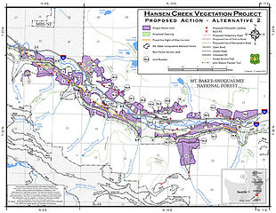 Proposed alternative 2 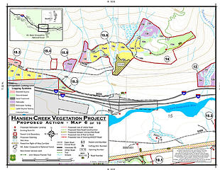 Road 9030 area logging 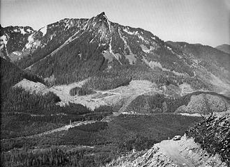 1960s era Bob & Ira Spring photo 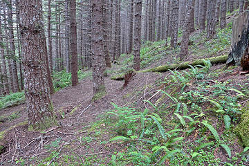 Second growth forest near old logging road below the Talapus Lake trail 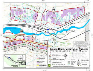 Units 18.1 and 18.2
|
| Back to top |
  
|
|
Kim Brown
Member

Joined: 13 Jul 2009
Posts: 6899 | TRs | Pics
|
Thanks puzzlr. The Cover Letter does mention some units being taken out altogether, but does not name which ones.
I'm confused on the map you posted. I see units 18.1 and 18.2, and the map on page 16 of the EA does include 18.1 and 18.2. The chart on page 17 discusses these units, as we. Where are you seeing 18.1 and 18.2 taken out?
I'm glad you're helping me read the thing and come up with questions, if any, to ask before sending a comment.
"..living on the east side of the Sierra world be ideal - except for harsher winters and the chance of apocalyptic fires burning the whole area."
Bosterson, NWHiker's marketing expert
"..living on the east side of the Sierra world be ideal - except for harsher winters and the chance of apocalyptic fires burning the whole area."
Bosterson, NWHiker's marketing expert
|
| Back to top |
|
|
puzzlr
Mid Fork Rocks
Joined: 13 Feb 2007
Posts: 7220 | TRs | Pics
Location: Stuck in the middle |
|
puzzlr
Mid Fork Rocks
|
Sat Mar 14, 2015 4:09 pm |
|
|
| Kim Brown wrote: | | Where are you seeing 18.1 and 18.2 taken out? |
One the first map I posted from page 223 for "Proposed Action - Alternative 4". It's included on the previous page in the Alternative 2 and 3 map.
However, now you've caused me to go back and read the document more carefully and I believe the Alternative 4 map is mislabeled. Page 20 says "This chapter describes Alternative 1 (No Action), Alternative 2 (the Proposed Action), and Alternatives 3 and 4."
Assuming that is correct, then logging at the Pratt Lake/Granite Mountain trailhead is in the proposed alternative. Here's the map for Alternative 2. So confusing.
Proposed alternative 2
|
| Back to top |
|
|
Kim Brown
Member
Joined: 13 Jul 2009
Posts: 6899 | TRs | Pics
|
It is confusing to go through these, because they have to address all points for each alternative, so there's a lot of repetition. It's easy to get lost in these things, not remembering which alternative you're reading about. I wish they'd use section breaks with footers so you can keep track of where the hell you are in the document.
Plus sometimes stuff misses the editing process.
"..living on the east side of the Sierra world be ideal - except for harsher winters and the chance of apocalyptic fires burning the whole area."
Bosterson, NWHiker's marketing expert
"..living on the east side of the Sierra world be ideal - except for harsher winters and the chance of apocalyptic fires burning the whole area."
Bosterson, NWHiker's marketing expert
|
| Back to top |
|
|
puzzlr
Mid Fork Rocks
Joined: 13 Feb 2007
Posts: 7220 | TRs | Pics
Location: Stuck in the middle |
|
puzzlr
Mid Fork Rocks
|
Sat Mar 14, 2015 4:28 pm |
|
|
Yeah, and I can imagine the project manager sending "Map Update Request Form 1032.F" to the GIS department to get an updated map with a title change and being rejected because of the short lead time! Just making that all up, but I wouldn't be surprised.
|
| Back to top |
|
|
nordique
Member

Joined: 04 May 2008
Posts: 1086 | TRs | Pics
|
|
nordique
Member
|
Sat Mar 14, 2015 6:24 pm |
|
|
Sorry but it's far past time to 'thin' in this area. Go to any trailhead within 50 miles of Seattle on a weekend and what do you see? Trailhead parking full and cars parked down approach roads for miles, often illegally, and with families, including kids and dogs, walking on busy roads to get to those trailheads. With thinning on the road to the Ira Spring trailhead, we ended up with mudslides down to I-90. Send those loggers over the pass to the GOP side of the state to do their logging--if there is any logging left.
|
| Back to top |
|
|
Ski
><((((°>

Joined: 28 May 2005
Posts: 12831 | TRs | Pics
Location: tacoma |
|
Ski
><((((°>
|
Sun Mar 15, 2015 12:13 am |
|
|
Kim - I read the first dozen or so pages and then skimmed through the rest of the document quickly.
Bear in mind that I'm not familiar with that area - the only one of those trails up there I've climbed was Granite Mountain, and that was at least 20 years ago, so my take on this is strictly from the documents you've cited here.
| Kim wrote: | | "The EA includes a buffer between cut and trail. However, the cuts will still be visible both through the buffer and from many viewpoints around and portions of the trails will be destroyed."
"A 21 acre clear-cut is an eyesore to those hiking; in the 1980's, people howled about it, the "Zorro" scars on the side of mountains prompted conservationists to form MTS Greenway." |
> From what I was able to understand, they're putting a 75-foot buffer along the trails. Looks to me like they're trying to steer clear of and maintain the trails. Did I miss something?
If I'm understanding the document correctly, the thinning units will be left with about a 70% canopy retention.
> The (up to) "21 acre openings" are not a regeneration units (clearcuts). They're saying 30% canopy retention, and (as I speculated earlier) there will be skips and leaves and "legacy" specimen retention.
Additionally, as mentioned in the comment responses, they're required to replant those units, even though the purpose is to try to re-create "early seral" conditions.
This isn't setting off any alarms for me.
They're all second-growth stands. They're all matrix units. There's nothing happening on LSR units.
There's nothing in the rule books requiring buffer zones around designated wilderness areas. (see Washington Wild "adjacent to...") That part is a non-issue.
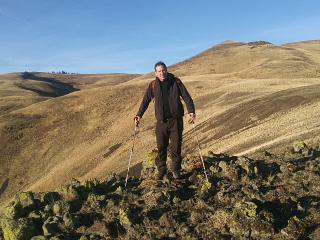
If the photo puzzlr posted above is a fair example of what it looks like, what I am seeing is an over-crowded fairly even-aged second-growth stand of only a couple species and a dearth of understory growth. It would probably benefit tremendously from a good thinning, although if it were up to me I'd go with only maybe 30-40% canopy retention (as opposed to their proposed 70%) to better mimic the effects of natural disturbances from lightning, windthrow, and wildfire. I'd say maybe 50-60% if it was in the cards they were going back in at some point in the future to do more, but it's pretty clear from the comment responses there's currently no plan (and may not be in the future) to go back in at a later date.
(As I mentioned in a different thread, the goalposts get moved now and then, so there's no predicting what may or may not happen 30-40-50 years down the road.)
I get that this is a popular area. But it's matrix NFS land. NFS has to cut wood somewhere- Congress said so.
That some matrix units had trails running through them when they started drawing lines on maps is one of the (probably unforeseen) consequent results of the NWFP.
I'd say try to make the best of it and demand trail upgrades and/or new bridges or trailhead facilities as part of the deal. Looks to me like they're going to a lot of trouble in that "mitigation" section to keep visual impact to a minimum.
I've been on trails where they clearcut right over the trail: Wright Meadow Trail (#80), and the multi-use trail up to Blue Lake (#271) just south of Randle. They looked like hell and were hot and dry and dusty (probably because of all the volcanic ash down there.) I'm not getting from the EA that the end result is going to look anything like that.
That said, here's the gist of what I'll include in a comment letter:
Trails, trailhead facilities and infrastructure, trailhead parking areas and approach roads be maintained and/or restored after operations to like or better conditions than exist at present.
Visual impacts to the trails themselves be minimized as is practicable and appropriate. (This is not the same as visual impact as seen from the trails - even within designated wilderness in National Parks visual impacts from harvest activity on lands outside NPS boundaries can be seen.)
Helicopter landing areas and landing sites for yarding which are near roads should be rehabilitated after operations and made inaccessible and unusable for purposes of "target shooting". (i.e., ditch and berm)
Where practicable and appropriate these areas should be replanted with native vegetation.
"I shall wear white flannel trousers, and walk upon the beach.
I have heard the mermaids singing, each to each."
"I shall wear white flannel trousers, and walk upon the beach.
I have heard the mermaids singing, each to each."
|
| Back to top |
|
|
Kim Brown
Member
Joined: 13 Jul 2009
Posts: 6899 | TRs | Pics
|
Thanks, Ski; I'm still going with the inappropriateness of portions of the project's location.
Oh, and I hope you had a happy Pi Day yesterday 
"..living on the east side of the Sierra world be ideal - except for harsher winters and the chance of apocalyptic fires burning the whole area."
Bosterson, NWHiker's marketing expert
"..living on the east side of the Sierra world be ideal - except for harsher winters and the chance of apocalyptic fires burning the whole area."
Bosterson, NWHiker's marketing expert
|
| Back to top |
|
|
Ski
><((((°>
Joined: 28 May 2005
Posts: 12831 | TRs | Pics
Location: tacoma |
|
Ski
><((((°>
|
Sun Mar 15, 2015 2:06 pm |
|
|
well.... to be quite honest, I'd prefer that no activity take place that impacts trails or other recreational facilities, but I don't think that's realistic.
from the maps puzzlr posted above, it appears they've got the buffers along the trails already drawn in, and unless I'm misreading the maps, those are pretty short little sections of trail being impacted: I'm not seeing anything on there where more than half a mile is being affected, and (again) they're proposing 75-foot buffer zones, so what you'll actually see from the trail will be more light coming through the canopy (provided that you can actually see through that 75-foot buffer.)
most likely from vista viewpoints things might look a little ragged for a couple years, but they're required to replant on those units, and with 70% canopy retention my guess is that the project areas will be difficult to pick out in a dozen years.
the proposed openings (with 30% canopy retention) will be a mess for a few years, but as above, after replanting they'll all be green again in 3-5 years and (hopefully) host some variety of species instead of what appears to be almost a monoculture stand in that photo of puzzlr's above.
but, as with the tiny logging project on Tiger, it won't matter where they do any harvesting, somebody's ox is getting gored.
In addition to the usual comments from industrial concerns and local tribes and a couple "environmental" groups, I think it would be appropriate and effective if both WTA and the Mountaineers submitted comment on their own (as opposed to the way it was done with "Washington Wild") and insist that every practicable and appropriate mitigation measure that can be done is effected to minimize impacts to the trails and users.
(just my lousy opinion, but the WW's headline link to the story ("adjacent to Alpine Lakes") reeks of alarmist hyperbole, and I think both WTA and the Mountaineers would do well do distance themselves from that. again - just my lousy opinion.)
"I shall wear white flannel trousers, and walk upon the beach.
I have heard the mermaids singing, each to each."
"I shall wear white flannel trousers, and walk upon the beach.
I have heard the mermaids singing, each to each."
|
| Back to top |
|
|
Kim Brown
Member
Joined: 13 Jul 2009
Posts: 6899 | TRs | Pics
|
It's on WTA's website. Easy to comment through their site if you agree with that position.
Add a personal story to the letter. Packs a better punch.
"..living on the east side of the Sierra world be ideal - except for harsher winters and the chance of apocalyptic fires burning the whole area."
Bosterson, NWHiker's marketing expert
"..living on the east side of the Sierra world be ideal - except for harsher winters and the chance of apocalyptic fires burning the whole area."
Bosterson, NWHiker's marketing expert
|
| Back to top |
|
|
Ski
><((((°>
Joined: 28 May 2005
Posts: 12831 | TRs | Pics
Location: tacoma |
|
Ski
><((((°>
|
Thu Mar 26, 2015 10:10 pm |
|
|
thanks Kim.
as I said previously, I think Andrea did a bang-up job on that letter.
hope they get it done with minimal impact and disruption to the recreational users.
bk
"I shall wear white flannel trousers, and walk upon the beach.
I have heard the mermaids singing, each to each."
"I shall wear white flannel trousers, and walk upon the beach.
I have heard the mermaids singing, each to each."
|
| Back to top |
|
|
Bernardo
Member

Joined: 08 Feb 2010
Posts: 2174 | TRs | Pics
Location: out and about in the world |
|
Bernardo
Member
|
Fri Mar 27, 2015 9:08 pm |
|
|
Looks like they will only be using the first part of the road out of the Ira Spring TH up till the hairpin turn. From just before the TH, they will be cutting from the current road up to the trail where it crosses the Mason Creek. Looks like they will take the logs down hill to the road. That's pretty steep terrain and the creek there floods and causes erosion.
They have planed an opening right below the TH which will open up nice views across the valley to McClellan Butte and the other peaks on that side.
I'm suppose I'm OK with everything below the road, but cutting above is pushing it for me. I've often wished a few of the trees below the TH were gone so they've cleverly placed that opening to appeal to the masses.
|
| Back to top |
|
|
Brucester
Member
Joined: 02 Jun 2013
Posts: 1102 | TRs | Pics
Location: Greenwood |
Earlier this week,I passed some thinning on a drive towards Windy Pass at Snoqualmie.
|
| Back to top |
|
|
Randito
Snarky Member

Joined: 27 Jul 2008
Posts: 9513 | TRs | Pics
Location: Bellevue at the moment. |
|
Randito
Snarky Member
|
Fri Mar 27, 2015 11:06 pm |
|
|
| Brucester wrote: | | Earlier this week,I passed some thinning on a drive towards Windy Pass at Snoqualmie. |
That is the Roaring Thin Project
|
| Back to top |
|
|
MyFootHurts
Huge Member

Joined: 22 Nov 2011
Posts: 912 | TRs | Pics
Location: Kekistan |
I would have thought occasional closures of the busiest, highest-impact trails into the wilderness would please the folks who think humans are pollution that need to stay out of the mountains.
Gives the land and the lakes "time to heal" from all the human pieces of sh## who dare to leave their sustainable 50-square ft microhousing units to go trespass upon Mother Nature.
|
| Back to top |
|
|
|
|
You cannot post new topics in this forum
You cannot reply to topics in this forum
You cannot edit your posts in this forum
You cannot delete your posts in this forum
You cannot vote in polls in this forum
|
Disclosure: As an Amazon Associate NWHikers.net earns from qualifying purchases when you use our link(s). |


