Tom
Admin

Joined: 15 Dec 2001
Posts: 17853 | TRs | Pics
|
|
Tom
Admin
|
 Sun Sep 15, 2002 3:29 pm |
|
|
On Saturday I hooked up with "Glacier Peak" (aka "Smokey Don") to climb White Chuck Mtn. We met at 6 AM just past Lynnwood and carpooled the remaining 1.5 hour drive to the trailhead. Don had printed out Mike Collins' WTA trip report for driving directions. As usual Mike's driving directions were flawless.  We knew to ignore the odometer and look for the logging road numbers. I was glad we took Don's 4x4 as a few sections in the last mile would have required some careful maneuvering in my lower clearance vehicle. In our zest to start hiking we parked at the first berm with views of the summit and hiked up the wrong abandoned road for a few minutes before quickly realizing our mistake and driving the main road another 1/8 of a mile or so, looking for the berm on the right (per Mike's directions).
From the "trailhead" we walked the abandoned road a short bit before noticing a route heading into the forest that appeared to be flagged (in hindsight this may be a more direct route to the basin). We continued on, looking for a stump with a cairn and found it a short distance later. Per Mike's WTA trip report, "the route is faintly visible at times". I will add that the bottom of my legs encountered a few sharp twigs and branches along the way. More annoying, however, were the bugs which swarmed us most of the way up. What the ..., this is supposed to be middle of September. We knew to ignore the odometer and look for the logging road numbers. I was glad we took Don's 4x4 as a few sections in the last mile would have required some careful maneuvering in my lower clearance vehicle. In our zest to start hiking we parked at the first berm with views of the summit and hiked up the wrong abandoned road for a few minutes before quickly realizing our mistake and driving the main road another 1/8 of a mile or so, looking for the berm on the right (per Mike's directions).
From the "trailhead" we walked the abandoned road a short bit before noticing a route heading into the forest that appeared to be flagged (in hindsight this may be a more direct route to the basin). We continued on, looking for a stump with a cairn and found it a short distance later. Per Mike's WTA trip report, "the route is faintly visible at times". I will add that the bottom of my legs encountered a few sharp twigs and branches along the way. More annoying, however, were the bugs which swarmed us most of the way up. What the ..., this is supposed to be middle of September.  I was tempted to put on some bug spray but Smokey Don was smoking me up the trail and I figured my perspiration would quickly wash away any protection.
The route up the gully looks quite daunting from the basin, but other than being steep it was not that bad. I won't rehash Mike's WTA report as he does a very good job of describing the route, other than to add I would not do this route in snow (at least not without ice axe) due to extremely short runout along much of the traverse to the Summit. Wet conditions would also prompt me to consider another destination. Also, bring a new notepad for the summit registry (it still hasn't been replaced).
Time to summit was a quick 2 hours, elevation gain was a mere 2900', and distance was less than 2.5 miles. Thanks to Don's peakbagger-like pace I still got a good workout. We spent roughly an hour on the summit, very appreciative of the breeze that kept the bugs at bay. By then, a couple we had passed along the way had made their way to the top, bringing with them a reinforcement of bugs and prompting us to head down.
On the way down, roughly 1/8 of a mile before reaching the gully, I followed a route to the top of the ridge offering impressive views of the glacier (which is not visible from the summit or the normal route). I called out to Don but didn't hear a response. As I was snapping a few pictures a huge avalanche / ice fall roared down near the bottom of the glacier, providing a reminder that while beautiful, it was nothing for the inexperienced to mess around with. As I scrambled down toward the gully I saw another peakbagger who fortunately pointed out Don to me (and vice versa) who was patiently waiting behind where I was coming down. The rest of the way down, Don was much too nimble for me to keep up with. We hooked up again at the bottom of the basin where he was more than happy to give up the berry picking and keep moving thanks to the swarming bugs. Though annoying, I didn't think the bugs were biting much until I checked out my arms and legs today. This is the worst I've been bitten in years. I was tempted to put on some bug spray but Smokey Don was smoking me up the trail and I figured my perspiration would quickly wash away any protection.
The route up the gully looks quite daunting from the basin, but other than being steep it was not that bad. I won't rehash Mike's WTA report as he does a very good job of describing the route, other than to add I would not do this route in snow (at least not without ice axe) due to extremely short runout along much of the traverse to the Summit. Wet conditions would also prompt me to consider another destination. Also, bring a new notepad for the summit registry (it still hasn't been replaced).
Time to summit was a quick 2 hours, elevation gain was a mere 2900', and distance was less than 2.5 miles. Thanks to Don's peakbagger-like pace I still got a good workout. We spent roughly an hour on the summit, very appreciative of the breeze that kept the bugs at bay. By then, a couple we had passed along the way had made their way to the top, bringing with them a reinforcement of bugs and prompting us to head down.
On the way down, roughly 1/8 of a mile before reaching the gully, I followed a route to the top of the ridge offering impressive views of the glacier (which is not visible from the summit or the normal route). I called out to Don but didn't hear a response. As I was snapping a few pictures a huge avalanche / ice fall roared down near the bottom of the glacier, providing a reminder that while beautiful, it was nothing for the inexperienced to mess around with. As I scrambled down toward the gully I saw another peakbagger who fortunately pointed out Don to me (and vice versa) who was patiently waiting behind where I was coming down. The rest of the way down, Don was much too nimble for me to keep up with. We hooked up again at the bottom of the basin where he was more than happy to give up the berry picking and keep moving thanks to the swarming bugs. Though annoying, I didn't think the bugs were biting much until I checked out my arms and legs today. This is the worst I've been bitten in years.  On the way home we stopped by the Whitehorse General Store on Don's recommendation. Where else can you get a waffle cone with a double scoop of premium ice cream for a mere $1.50? We didn't imbibe, but they also had ice cold beers for 79 cents. We made it back to the park & ride by 2:30 on a day that was far too pleasant to be spent entirely in the mountains. At home I checked out my pictures to find my camera had once again encountered focus problems. Fortunately they don't look too bad when resized to web view. Enjoy!
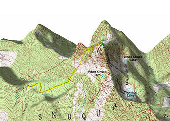 3D Map Of Scramble To White Chuck Mtn 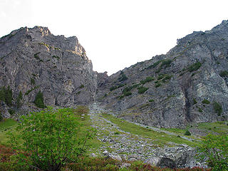 Looking Up The Gully From The Basin 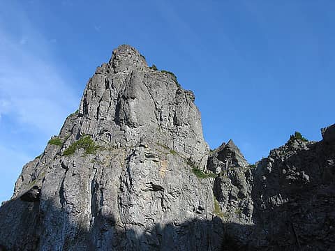 Looking Up To Northwest Peak From Route To White Chuck Mtn 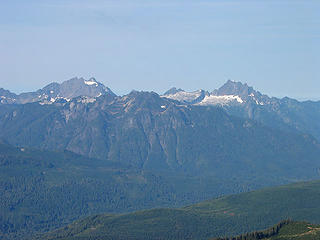 Looking Across To Three Fingers, Jumbo, And Whitehorse Mtn From Route To White Chuck Mtn 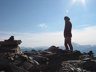 Don Checking Out The Views From White Chuck Summit 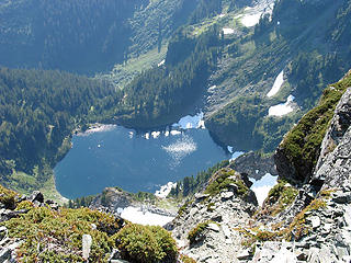 Looking Down To Thornton Lake From White Chuck Summit 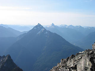 Mt Pugh, Sloan, And Monte Cristo Peaks From White Chuck Summit 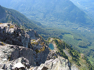 Peering Down To White Chuck Tarn From Summit  Don Signing The White Chuck Registry 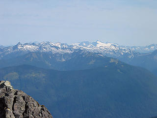 Looking Northeast To Green Mtn And Beyond 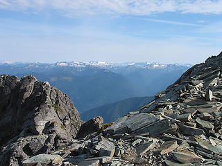 Looking Northeast From The Summit 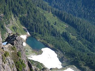 Northern White Chuck Lake 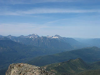 Three Fingers, Jumbo, White Horse Mtn, And Darrington From White Chuck Summit 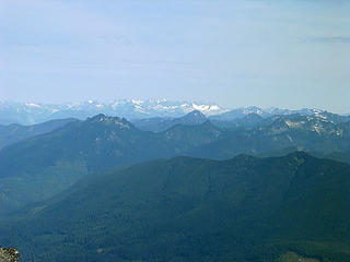 Looking North To Pickets From White Chuck Summit 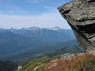 Three Fingers, Jumbo, And White Horse Mtn From White Chuck Mtn 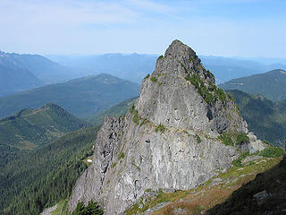 Northwest Peak From White Chuck Mtn 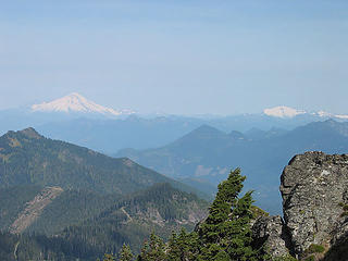 Mt Baker And Mt Shuksan From White Chuck Mtn 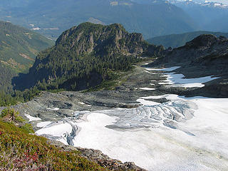 Crevased Glacier On Northwestern Slopes Of White Chuck Mtn 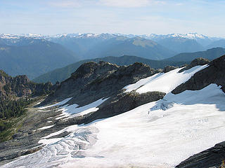 Looking Down To Glacier On Northwestern Slopes Of White Chuck Mtn And Northeast To Peaks In Distance 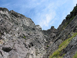 Looking Up To Top Of Gully On White Chuck Mtn (Fortunately You Don't Have To Go Up This) 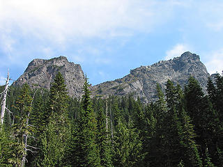 Looking Back To White Chuck Mtn From Meadows Below
|


