| Previous :: Next Topic |
| Author |
Message |
raising3hikers
Member


Joined: 21 Sep 2007
Posts: 2344 | TRs | Pics
Location: Edmonds, Wa |
This peak inside Mt Rainier National Park is tough to see from just about anywhere unless you know exactly where to look. It stands 6670' tall with 430' of prominence and everyone i've asked about it thinks it has been unclimbed before. When viewed from the West, it blends into the taller ridges as it divides the Puyallup glacier into two tongues. On a trip last fall in the Glacier View Wilderness with iron, we made a point to try and see the peak and come up with ideas on how to climb it. The westside gullies up either side of the steep looking peak appeared extremely horrible with glacier debris and waterfalls all through out. So a glacier plan was put into place with a lot of elevation gain and loss.
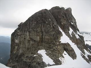 Nasatin Pk 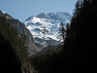 Rainier from the S Puyallup bridge  Rainier 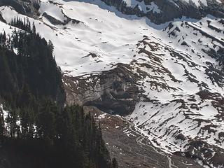 looking down at the Tahoma glacier terminus 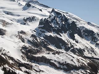 Glacier Island 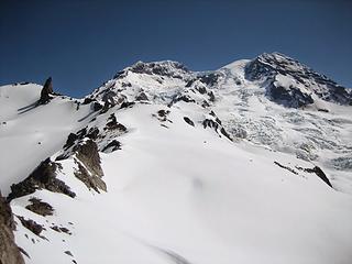 Tokaloo Rock(L) and Rainier 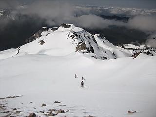 hiking along the ridge 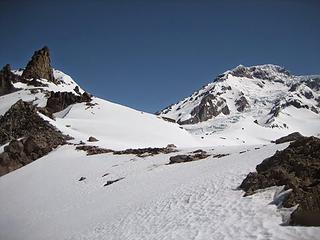 Tokaloo Spire and Sunset Amphitheater 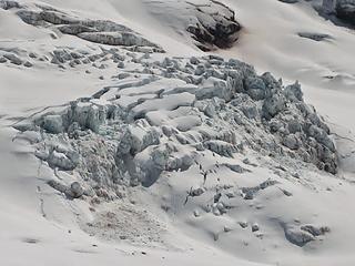 Tahoma glacier 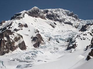 Puyallup glacier 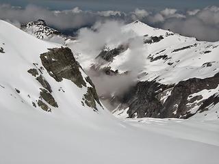 the view down the Puyallup glacier valley, where we'd go 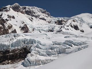 the awesome Puyallup glacier 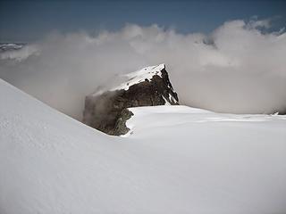 Nesatin Pk emerging from the fog 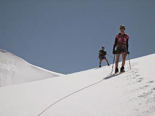 bluebird day on the glacier 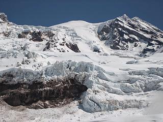 what a view! 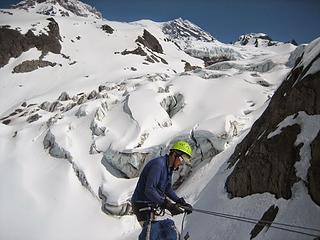 Stefan ready to rappel 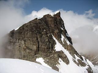 another look at Nesatin 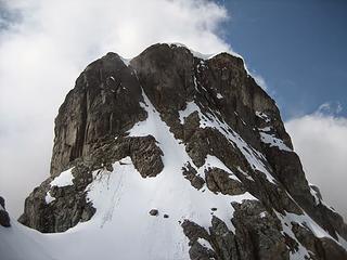 We took the highest and longest snow gully on left 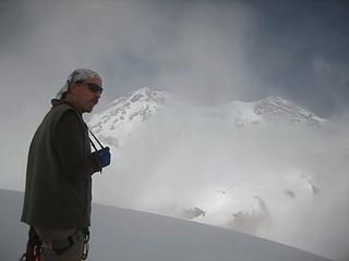 Greg at the Nesatin summit 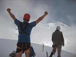 iron hoping for a better view 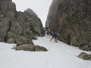 iron coming down the gully 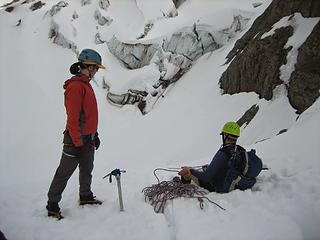 Hotpantz and Stefan at the belay station 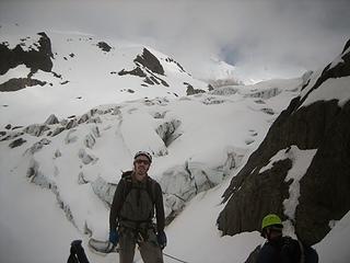 Greg 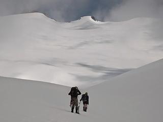 Greg and Stefan 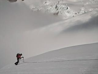 Hotpantz emerging from the cloud 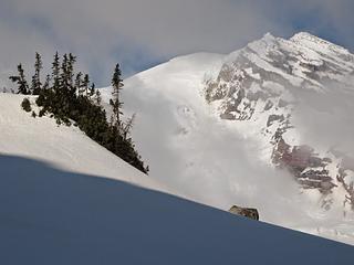 last look at Rainier 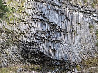 volcanic rock near the S Puyallup trail
|
| Back to top |
  
|
|
wildernessed
viewbagger

Joined: 31 Oct 2004
Posts: 9275 | TRs | Pics
Location: Wenatchee |

Living in the Anthropocene
Living in the Anthropocene
|
| Back to top |
|
|
Distel32
Member
Joined: 03 Jun 2014
Posts: 961 | TRs | Pics
Location: Edmonds, WA |
|
Distel32
Member
|
 Mon May 04, 2015 6:33 pm |
|
|
unique find!
|
| Back to top |
|
|
RichP
Member

Joined: 13 Jul 2006
Posts: 5633 | TRs | Pics
Location: here |
|
RichP
Member
|
Mon May 04, 2015 6:42 pm |
|
|
I've never heard of that one. Great shots of The Mountain.
|
| Back to top |
|
|
Tom_Sjolseth
Born Yesterday

Joined: 30 May 2007
Posts: 2652 | TRs | Pics
Location: Right here. |
|
| Back to top |
|
|
Justus S.
Member
Joined: 17 Nov 2004
Posts: 1298 | TRs | Pics
Location: WA |
Nice! A few years ago when I looked at all the peaks in the park I thought that would be a interesting peak to visit.
|
| Back to top |
|
|
MyFootHurts
Huge Member

Joined: 22 Nov 2011
Posts: 912 | TRs | Pics
Location: Kekistan |
wow.
All I did today was schlep up the old Mt Si trail and turn around about 1 mile before the top.
|
| Back to top |
|
|
b00
Member

Joined: 29 Sep 2003
Posts: 1144 | TRs | Pics
|
|
b00
Member
|
Mon May 04, 2015 9:40 pm |
|
|
| raising3hikers wrote: | | Hotpantz suggested we tag Tokaloo, so her, Iron and I went up |
huh? a first ascent wasn't enough. she sure has been bitten by the peak bagging bug.
great job guys! you are awesome!
:>)
|
| Back to top |
|
|
iron
Member

Joined: 10 Aug 2008
Posts: 6392 | TRs | Pics
Location: southeast kootenays |
|
iron
Member
|
Mon May 04, 2015 9:42 pm |
|
|
pics of the peak from afar:
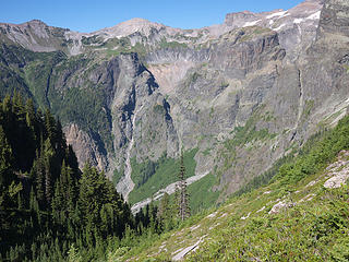 View into North Puyallup from between St. Andrews and Klapache Park
|
| Back to top |
|
|
Magellan
Brutally Handsome

Joined: 26 Jul 2006
Posts: 13116 | TRs | Pics
Location: Inexorable descent |
|
Magellan
Brutally Handsome
|
Mon May 04, 2015 10:25 pm |
|
|
Great story! Congrats on the probably FA.
|
| Back to top |
|
|
the Zachster
Member

Joined: 17 Jan 2007
Posts: 4776 | TRs | Pics
Location: dog training |
What an awesomely obscure and fabulous trip! I LOVE that part of the Park. It looks very different in snow, but is this it?
"May I always be the kind of person my dog thinks I am"
"May I always be the kind of person my dog thinks I am"
|
| Back to top |
|
|
silence
Member

Joined: 25 Apr 2005
Posts: 4420 | TRs | Pics
|
|
silence
Member
|
Tue May 05, 2015 7:19 am |
|
|
Awesome climb ... way to go guys.
And yeah ... the Puyallup Glacier is pretty awesome too!
PHOTOS
FILMS
Keep a good head and always carry a light bulb. Bob Dylan
PHOTOS
FILMS
Keep a good head and always carry a light bulb. Bob Dylan
|
| Back to top |
|
|
hotpantz
Member

Joined: 20 Jan 2014
Posts: 4 | TRs | Pics
|
|
hotpantz
Member
|
Tue May 05, 2015 8:41 am |
|
|
| b00 wrote: | | raising3hikers wrote: | | Hotpantz suggested we tag Tokaloo, so her, Iron and I went up |
huh? a first ascent wasn't enough. she sure has been bitten by the peak bagging bug.
great job guys! you are awesome!
:>) |
Not quite. I wasn't confident in my ability to get up the peak, so I held back (bummer! because it went easily enough), so I wanted to get up something and coaxed Eric and Mike to climb Tokaloo with me.
|
| Back to top |
|
|
Stefan
Member

Joined: 17 Dec 2001
Posts: 5091 | TRs | Pics
|
|
Stefan
Member
|
Tue May 05, 2015 8:48 am |
|
|
And some more pictures. Thanks for the day!
|
| Back to top |
|
|
Jetlag
Member
Joined: 17 Aug 2010
Posts: 1410 | TRs | Pics
|
|
Jetlag
Member
|
Tue May 05, 2015 8:52 am |
|
|
Splendid early May jaunt on those Westside glaciers. They are what I look at most mornings from my cabin. When the Westside road was driveable, I used to take students up to see that wonderful view from Tokaloo Rock. Never noticed that great snow route up newly-named Nesatin!
|
| Back to top |
|
|
|
|


