| Previous :: Next Topic |
| Author |
Message |
Randy
Cube Rat


Joined: 18 Dec 2001
Posts: 2910 | TRs | Pics
Location: Near the Siamangs |
|
Randy
Cube Rat
|
 Sun Jun 05, 2005 1:39 pm |
|
|
With just a day allotted for a trip this weekend, Craig and I decided that wed clean up on a couple peaks up the Phelps Creek trail. Seven Fingered Jack (7FJ) and Mount Maude are technically easy peaks, but their height and locale make them great destinations for the obsessed peakbagger in all of us. We made the long drive over from Seattle to the TH (elevation 3500), threw the truck in a parking spot, and had feet moving at 0830.
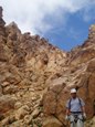
We set a relaxed pace up the Phelps Creek trail, the only difficulty trying to stay dry across the high creek crossings in my sneakers. After about 3.2 miles, we reached Leroy Creek where we dropped a bit below the trail and crossed on a small log. Immediately, we found the trail leading up to Leroy Basin on the north side of the creek, elevation 4100. The trail takes off like a bandit straight up the hill and my calves were thrown awake as they worked to get me up the hill. The trail is in fine shape all the way up to the basin at about 6100 where we got our first good views of 7FJ and the route we needed to take. We followed the trail away from the basin to the NE and gained a couple hundred feet before we left it for the more direct cross country route up 7FJ. The trail takes one across the headwalls of the basin and is essentially a route for Maude best I can tell. Anyhow, we continued straight up the hill on scree, rock and minor snow patches directly underneath what looks to be a cave from the basin. At about 8000 the terrain steepened, and I had to reluctantly remove my sneakers and go with heavy boots for the remainder of the day. Here, we encountered a steep-ish, 300-foot snow slope as we turned to parallel the summit towers of 7FJ (we were probably a bit off the standard route through here). The snow was still hard from the cool morning air and we had to carefully carve out footholds to keep from ending up back in the basin. Once on top we traversed more steep snow before getting into the final gully system below the summit. I cursed the snow and scree through the final couple of gullies; if we werent postholing up to our waste we were surfing rocks in the wrong direction. The true summit is as far north as you can go and we finally arrived after 5 hours, that last 1000 taking forever in the less than ideal conditions. Clear skies in all directions yielded great views, but I was especially thankful for the nice flat spot on the summit where I could lay down and enjoy my candy bar.
We left the summit at 1400 and descended back along the summit towers the same way we had come up. The snow had softened just enough to where we could plunge step down the steeper sections, but at the same time we were now postholing like mad. We resorted to a series of steep glissades to get down to flat terrain just below the southern most summit of 7FJ at about 7900. We kept as high as possible aiming for a distant W spur ridge coming off Maude. There looked to be a ramp system at about 7200 on this spur that would takes us up and over to the broad S ridge of Maude. After a porous snow traverse, we eventually made it to this ramp system and took it up and over aiming for tracks up a snow slope to the S ridge of Maude. What doesnt show up on maps however is the 50 band of cliffs that prevents access to the snow slope unless youre down at about 7000. Too high, we had to reluctantly drop a couple hundred feet and skirt around the terminus of the cliff system. We cut briefly across the basin then booted it up about 200 of scree before getting onto the snow slope (now on the standard route for Maude). We traded off leads up the snow and after 900 we were on the S ridge at 8100, ready to get this whole ordeal over with! The route up the S ridge is as easy as it gets up grass and rock. At 8700 we came across a mother Ptarmigan in the midst of adjusting plumage with her brood nicely hidden amongst the rocks. The last 50 to the summit were on snow and the summit was a welcome sight after 9 hours or so on the go. It was nice to look back over to 7FJ and the views over to Glacier Peak were great as it was half in and out of the clouds. We didnt stay long as it looked like weather might be moving in and thoughts of warm food in Leavenworth were starting to dominate motivations between the two of us. Sometimes cheese nips and gummie bears just dont cut it.
Back down the S ridge and then a series of long glissades got us back down to about 6900 where we picked up the trail leading back down into Leroy Basin. We cut back across the basin and briefly spoke to a couple guys who had been over on Fernow earlier in the day. We hurried down the steep trail and to the Phelps Creek trail without much incident. Once down to flat terrain, we came across a fat porcupine lumbering along side the trail. It was hard to tell if he was afraid of or not as he was darned slow and just kept going from one side of the trail to the other doing his thing. Neat to see nonetheless and a good capper to a fine day in the hills. A few more miles of flat trail later we were back at the car at 2100.
For those considering this trip, word on the street is that the route goes 13 miles with 7700 of gain.
|
| Back to top |
  
|
|
Jeff R
Closet hiker.
Joined: 10 Apr 2005
Posts: 972 | TRs | Pics
Location: Everret |
|
Jeff R
Closet hiker.
|
Sun Jun 05, 2005 1:51 pm |
|
|
Nice little walk you did there, in one day!  How about that gnarly 25' deep gully crossing above and to the south of leroy creek basin, on the Carne mountain high route ,leading towards Maude? Did you encounter something like this? How about that gnarly 25' deep gully crossing above and to the south of leroy creek basin, on the Carne mountain high route ,leading towards Maude? Did you encounter something like this?
|
| Back to top |
|
|
Backpacker Joe
Blind Hiker

Joined: 16 Dec 2001
Posts: 23956 | TRs | Pics
Location: Cle Elum |
Pictures pictures pictures!
You guys are animals....
Randy, what was the condition of Ice lakes???
Tom
"If destruction be our lot we must ourselves be its author and finisher. As a nation of freemen we must live through all time or die by suicide."
Abraham Lincoln
"If destruction be our lot we must ourselves be its author and finisher. As a nation of freemen we must live through all time or die by suicide."
Abraham Lincoln
|
| Back to top |
|
|
philfort
Member

Joined: 02 Sep 2003
Posts: 443 | TRs | Pics
Location: seattle |
|
philfort
Member
|
Sun Jun 05, 2005 2:25 pm |
|
|
I think this must be you guys traversing under Maude? Around 3:20pm yesterday.
|
| Back to top |
|
|
Randy
Cube Rat
Joined: 18 Dec 2001
Posts: 2910 | TRs | Pics
Location: Near the Siamangs |
|
Randy
Cube Rat
|
Sun Jun 05, 2005 2:37 pm |
|
|
Yup that's us. You must have been the skiers we saw.
|
| Back to top |
|
|
Randy
Cube Rat
Joined: 18 Dec 2001
Posts: 2910 | TRs | Pics
Location: Near the Siamangs |
|
Randy
Cube Rat
|
Sun Jun 05, 2005 2:52 pm |
|
|
I saw one of the Ice Lakes and it was completely frozen over. However, there were some patches of lighter blue showing through, so it's starting to thin.
|
| Back to top |
|
|
Beave
Member

Joined: 21 Dec 2001
Posts: 276 | TRs | Pics
Location: Woodinville |
|
Beave
Member
|
Sun Jun 05, 2005 4:25 pm |
|
|
Damn, we deserve a little more credit than that  I traced out our route and came up with the following:
8500' gain, 14 miles RT and 12.5 hrs car-to-car
Thanks for the pic Phil; Thats a photo perspective I've never gotten a chance to enjoy until now.
Beave
I traced out our route and came up with the following:
8500' gain, 14 miles RT and 12.5 hrs car-to-car
Thanks for the pic Phil; Thats a photo perspective I've never gotten a chance to enjoy until now.
Beave
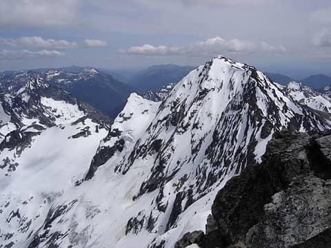 Maude from 7FJ 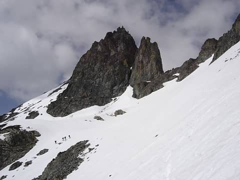 Climbers Below 7FJ 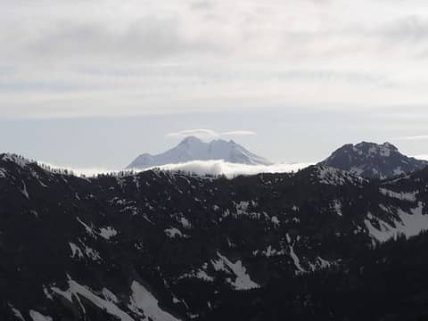 Glacier Peak 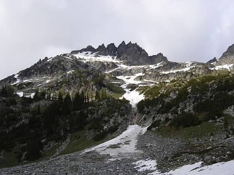 7FJ
|
| Back to top |
|
|
|
|


