| Previous :: Next Topic |
| Author |
Message |
Guiran
Member


Joined: 03 Mar 2004
Posts: 621 | TRs | Pics
Location: University of Washington |
|
Guiran
Member
|
 Sun Jul 17, 2005 3:56 pm |
|
|
The Plan:
Set up a carry ferry on Wednesday at the Slide Lake TH and the end of Tenas Creek Road. Over the next three days, our group of four would traverse a high route in glorious weather from Hurricane Peak to Snowking Mtn.
The Reality:
Two of us literally sloshed out of Illabot Creek on Saturday evening, bedraggled and beaten, having been turned back from Snowking and spent nearly half the trip travelling in near white-out conditions. As we hoofed it back up the road to where the car had been stashed, we weren't capable of saying much more than, "Epic, man. Just epic."
The Story:
The car ferry got set up on Wednesday night without incident. Took a little longer than anticipated, but both Illabot Road and Tenas Creek Road were very drivable. Got a sluggish start Thursday morning, but were up and moving on the fishermans trail to Boulder Lake at little after 10. The trail features an impressive waterfall and looks to have been better maintained in the past. In fact, there is even a Glacier Peak Wilderness sign at the wilderness boundary, which I didnt think was that common for a fishermans trail. Our pace, however, was pretty slow and Charles and I were getting worried about managing the traverse in three days. We set out ahead of our other two compatriots and headed up to Pear Lake and then up a steep, mossy gully to a saddle below the top of the ridge to the east of Pear. When the other two members of our party failed to join up with us, Charles and I dropped our packs and, after and hour of traversing the ridge, found them down at Pear Lake, laboring along. Not good. Charles and I had badly underestimated how slowly fit, but inexperienced, backpackers move on challenging terrain. Around 5 PM we pulled in to our camp a bench about 500 ft above Lake Toketie. Charles and I decided to head up Hurricane Peak for an evening stroll and took in the magnificent views of Cheval, Buckindy, and Glacier. Found a few familiar names in the register, including one Tom Davenport whos known to lurk on the boards.  That night we discussed our options and decided that wed split up. The two less experienced members of our party would head back to the car at Tenas Creek while Charles and I would try to complete the traverse in two days. Sure the weather looked to be deteriorating, but how bad could it get?
  Up and moving early the next morning, we headed north below Hurricane Peak and picked up the ridge running to Pt 6078. There was a faint climbers trail for much of the traverse which clung to the top of the narrow, occasionally exposed ridge. Experienced some nasty side-hilling as we came around the east side of Crater Lake (about 1000 ft up). Once we started heading west around the lake basin, the slick heather was replaced by large granite blocks which made for really enjoyable walking. As we reached the 6400 col to the east of Chevals east peak we felt our first drops of rain. Sure it had been getting cloudier during the morning, but things looked better to the west. Conditions were bound to improve. Right? We glissaded down into the cloud shrouded cirque at the origin of Buck Creek. On the way down we came across some curious wreckage including a metal tube, canvas, and some small wooden looking floats. Further down in the basin, I would come across some yellow, rubbery looking fabric and some rusted pole sections. Someone trying to raft down the cliff bands? Conditions continued to deteriorate as we descended and soon we were down to only a hundred feet or so of visibility and blowing rain. The descent down to Buck Creek was pure misery. Wet brush, no visibility to speak of, and constant green belays. We missed the correct ridge and halted our descent only when a brief break in the clouds showed the creek floor still nearly a thousand feet below us (the basin should have only been a hundred or so). In good weather, the descent would probably be straightforward, but in drifting clouds and rain it kinds of blows. Casualties for the descent: a nalgene bottle, a carbon fiber trekking pole that snapped like a twig, and a pair of boxers that ripped from stem to stern since the designers apparently never thought theyd be worn in heavy rain. Upon reaching the desolate basin, we took refuge beneath an overhung boulder in the Buck Creek basin, trying to stay out of the rain while we choked down some food. A few times I thought the rain had stopped, but then realized the wind had intensified and it was just blowing sideways. This was really the low point of the trip for me near hypothermic, stuffed under a boulder, with a 1500 ft climb to get up to our camp. The waterfall coming down over the cliffs of the upper cirque was really impressive, though.
Some additional brush bashing (we were starting to get pretty good at it) got us to the base of a talus slope heading up towards the Illabot-Buck divide. For anyone who has a hankering to give this route a shot, take the ridge at the east end of the Buck basin all the way down. By descending into a lower basin you can avoid hopping gravel bars and some of the brush busting and set yourself up nicely to ascend the talus slope. Once we were back on solid talus, our spirits started to improve. The walking was easy, the clouds were starting to break up, and we were feeling pretty good about ourselves. Dropped over the ridge into the Illabot Creek drainage and steadily made our way up the side of the ridge to Pt. 6042. Here we had a bout of confusion. The GT map said there should be a lake just below us, but we couldnt see a thing in the fog and clouds. Had we somehow managed to end up on the wrong ridge? Then the clouds broke a bit and we discovered we were about 50 ft above the lake. Good times.
Made camp in a col on the low, undulating ridge running along the west side of the lake. Interestingly, the lake does not show up on the USGS map (but its really large) and the basin beyond looks to contain glacial ice, even though none is indicated. We went to bed hoping that the weather would clear up by morning and wed be able to get some views on our way over Snowking. Youd think by now wed have learned not to set expectations that high?
Up and moving early the next morning, we headed north below Hurricane Peak and picked up the ridge running to Pt 6078. There was a faint climbers trail for much of the traverse which clung to the top of the narrow, occasionally exposed ridge. Experienced some nasty side-hilling as we came around the east side of Crater Lake (about 1000 ft up). Once we started heading west around the lake basin, the slick heather was replaced by large granite blocks which made for really enjoyable walking. As we reached the 6400 col to the east of Chevals east peak we felt our first drops of rain. Sure it had been getting cloudier during the morning, but things looked better to the west. Conditions were bound to improve. Right? We glissaded down into the cloud shrouded cirque at the origin of Buck Creek. On the way down we came across some curious wreckage including a metal tube, canvas, and some small wooden looking floats. Further down in the basin, I would come across some yellow, rubbery looking fabric and some rusted pole sections. Someone trying to raft down the cliff bands? Conditions continued to deteriorate as we descended and soon we were down to only a hundred feet or so of visibility and blowing rain. The descent down to Buck Creek was pure misery. Wet brush, no visibility to speak of, and constant green belays. We missed the correct ridge and halted our descent only when a brief break in the clouds showed the creek floor still nearly a thousand feet below us (the basin should have only been a hundred or so). In good weather, the descent would probably be straightforward, but in drifting clouds and rain it kinds of blows. Casualties for the descent: a nalgene bottle, a carbon fiber trekking pole that snapped like a twig, and a pair of boxers that ripped from stem to stern since the designers apparently never thought theyd be worn in heavy rain. Upon reaching the desolate basin, we took refuge beneath an overhung boulder in the Buck Creek basin, trying to stay out of the rain while we choked down some food. A few times I thought the rain had stopped, but then realized the wind had intensified and it was just blowing sideways. This was really the low point of the trip for me near hypothermic, stuffed under a boulder, with a 1500 ft climb to get up to our camp. The waterfall coming down over the cliffs of the upper cirque was really impressive, though.
Some additional brush bashing (we were starting to get pretty good at it) got us to the base of a talus slope heading up towards the Illabot-Buck divide. For anyone who has a hankering to give this route a shot, take the ridge at the east end of the Buck basin all the way down. By descending into a lower basin you can avoid hopping gravel bars and some of the brush busting and set yourself up nicely to ascend the talus slope. Once we were back on solid talus, our spirits started to improve. The walking was easy, the clouds were starting to break up, and we were feeling pretty good about ourselves. Dropped over the ridge into the Illabot Creek drainage and steadily made our way up the side of the ridge to Pt. 6042. Here we had a bout of confusion. The GT map said there should be a lake just below us, but we couldnt see a thing in the fog and clouds. Had we somehow managed to end up on the wrong ridge? Then the clouds broke a bit and we discovered we were about 50 ft above the lake. Good times.
Made camp in a col on the low, undulating ridge running along the west side of the lake. Interestingly, the lake does not show up on the USGS map (but its really large) and the basin beyond looks to contain glacial ice, even though none is indicated. We went to bed hoping that the weather would clear up by morning and wed be able to get some views on our way over Snowking. Youd think by now wed have learned not to set expectations that high?  The next morning we hurriedly packed up cramp in a break in the rain and set out up the ridge to Pt. 6995 with basically no visibility. The wet talus was not fun for walking and became even less fun above 6500 ft where it was slathered in black lichen. Around 6800 we encountered a local high point on the ridge without any good way around. In drier weather with better visibility, we might have continued on, but as it was, we decided to bail. I think a better route might be to traverse to the right of the ridge, where the snow and talus looks to be pretty low-gradient, but to be fair, this opinion is based only on a few glimpses of snowfield as we were coming back down. We staggered back into our campsite at 12:30, and pulled out our maps to figure out possible bail routes. After some half-hearted consideration of going up the south side of Snowking by traveling on glacier not shown on any map, we decided instead to bail by traversing the steep southern flanks of Snowking to reach the relative safety of an unnamed lake around 4700. The worst part of the bail was the very beginning where we crossed the roaring outlet of the basin on a snowbridge of questionable stability. The scene was one of swirling fog, water running and pooling over ice, and desolate glacial debris. Kind of what hell might look like if it froze over. Once beyond this impasse it was all sidehilling on talus and heather until we crossed over a ridge below Pt 6100. Here, for the first time in nearly two days, we had a stunning view of Snowkings shoulder barren slabs and hanging snowfields. We descended to flat meadow around 5200 where we were pursued by a pack of mosquitos all the way down to the lake. We circumnavigated the lake in wet, but manageable brush looking for a purported fishermans trail, but finding nothing (except for a firepit) resigned ourselves to a miserable bushwhack down the final 2500 to Illabot Creek. And thats when we finally had a ray of luck in this otherwise cursed adventure after crossing a creek we stumbled upon a very faint tread. Wed found the fishermans trail! The trail clearly sees little use, but we were able to follow nearly to Illabot Creek before losing it at a massive washout. At some time in the distant past, this was clearly a better maintained route. A number of huge moss covered blowdowns showed the marks of a cross-cut saw and in other places notches had been hacked in logs to make for an easier crossing. In hindsight, we probably should have tried to descend the washout and find the trail on the other side, but with Illabot Creek nearly in view, we chose instead to bust down through the brush. I didnt know brush could grow so thick. It was with great relief that we broke out on the banks of Illabot Creek about ½ mile from the road. After an attempt to bushwhack through the brush lining the creek we decided to abandon our dry feet and waded down the creek, crossing gravel and sand benches with many interesting animal tracks. As we rounded the final bend and saw the bridge of Illabot Creek Road I could have nearly wept. Dropping packs, we briskly walked a mile or so back up the road to the Slide Lake trailhead where our car was waiting. Epic. Just epic.
Despite my personal epic meter having spent probably a good quarter of the trip pegged heavily in the red, Im already suffering from trip amnesia and want to go back. I think something may be wrong with me.
The next morning we hurriedly packed up cramp in a break in the rain and set out up the ridge to Pt. 6995 with basically no visibility. The wet talus was not fun for walking and became even less fun above 6500 ft where it was slathered in black lichen. Around 6800 we encountered a local high point on the ridge without any good way around. In drier weather with better visibility, we might have continued on, but as it was, we decided to bail. I think a better route might be to traverse to the right of the ridge, where the snow and talus looks to be pretty low-gradient, but to be fair, this opinion is based only on a few glimpses of snowfield as we were coming back down. We staggered back into our campsite at 12:30, and pulled out our maps to figure out possible bail routes. After some half-hearted consideration of going up the south side of Snowking by traveling on glacier not shown on any map, we decided instead to bail by traversing the steep southern flanks of Snowking to reach the relative safety of an unnamed lake around 4700. The worst part of the bail was the very beginning where we crossed the roaring outlet of the basin on a snowbridge of questionable stability. The scene was one of swirling fog, water running and pooling over ice, and desolate glacial debris. Kind of what hell might look like if it froze over. Once beyond this impasse it was all sidehilling on talus and heather until we crossed over a ridge below Pt 6100. Here, for the first time in nearly two days, we had a stunning view of Snowkings shoulder barren slabs and hanging snowfields. We descended to flat meadow around 5200 where we were pursued by a pack of mosquitos all the way down to the lake. We circumnavigated the lake in wet, but manageable brush looking for a purported fishermans trail, but finding nothing (except for a firepit) resigned ourselves to a miserable bushwhack down the final 2500 to Illabot Creek. And thats when we finally had a ray of luck in this otherwise cursed adventure after crossing a creek we stumbled upon a very faint tread. Wed found the fishermans trail! The trail clearly sees little use, but we were able to follow nearly to Illabot Creek before losing it at a massive washout. At some time in the distant past, this was clearly a better maintained route. A number of huge moss covered blowdowns showed the marks of a cross-cut saw and in other places notches had been hacked in logs to make for an easier crossing. In hindsight, we probably should have tried to descend the washout and find the trail on the other side, but with Illabot Creek nearly in view, we chose instead to bust down through the brush. I didnt know brush could grow so thick. It was with great relief that we broke out on the banks of Illabot Creek about ½ mile from the road. After an attempt to bushwhack through the brush lining the creek we decided to abandon our dry feet and waded down the creek, crossing gravel and sand benches with many interesting animal tracks. As we rounded the final bend and saw the bridge of Illabot Creek Road I could have nearly wept. Dropping packs, we briskly walked a mile or so back up the road to the Slide Lake trailhead where our car was waiting. Epic. Just epic.
Despite my personal epic meter having spent probably a good quarter of the trip pegged heavily in the red, Im already suffering from trip amnesia and want to go back. I think something may be wrong with me. 
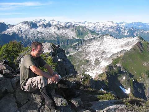 Hurricane Peak. Ridge traverse in background. Register cap on very tight.  Ridge traverse from Hurricane. 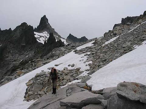 Approaching Mt. Cheval. Kind of imposing. 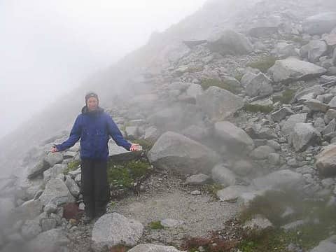 On route? Who can know for sure? 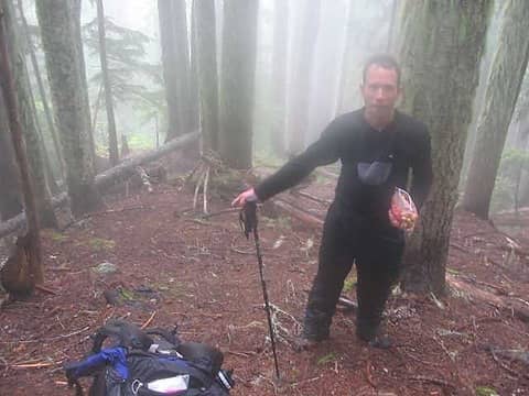 I'm actually pointing at the tread of a "well established" fisherman's trail. 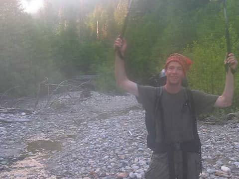 End of an Epic
|
| Back to top |
  
|
|
Trevor
Member
Joined: 31 Jan 2004
Posts: 1562 | TRs | Pics
Location: Edmonds, WA |
|
Trevor
Member
|
Sun Jul 17, 2005 6:30 pm |
|
|
| Quote: | | Found a few familiar names in the register, including one Tom Davenport whos known to lurk on the boards. |
No. . .I don't recall him ever visiting this site.
Fantastic trip report and images, really enjoyed it. The conquest of the adverse conditions always seems to heighten the desire to be adventurous. I've been really curious about this area ever since investigating it, glad you could whet the appetite with a tr and images! Chaval does look quite intimidating.
|
| Back to top |
|
|
Guiran
Member
Joined: 03 Mar 2004
Posts: 621 | TRs | Pics
Location: University of Washington |
|
Guiran
Member
|
Sun Jul 17, 2005 6:44 pm |
|
|
I get the impression that the aspect of Cheval from the other side is a little less intense. Going to need to head back and give it a shot some day soon.
|
| Back to top |
|
|
Backpacker Joe
Blind Hiker

Joined: 16 Dec 2001
Posts: 23956 | TRs | Pics
Location: Cle Elum |
That is some report brother. Next time you need to be more sure of the weather AND the condition of the people going alone. No offense meant, but that stuff is critical. I've been there and I've made those mistakes. Mostly with myself (not being in the condition necessary) for such an endeavor.
Nice report. Can I see pictures of that aircraft wreckage????
Tom
"If destruction be our lot we must ourselves be its author and finisher. As a nation of freemen we must live through all time or die by suicide."
Abraham Lincoln
"If destruction be our lot we must ourselves be its author and finisher. As a nation of freemen we must live through all time or die by suicide."
Abraham Lincoln
|
| Back to top |
|
|
Guiran
Member
Joined: 03 Mar 2004
Posts: 621 | TRs | Pics
Location: University of Washington |
|
Guiran
Member
|
Sun Jul 17, 2005 8:04 pm |
|
|
Here's the stuff we found on the cirque walls. Any idea what it is?
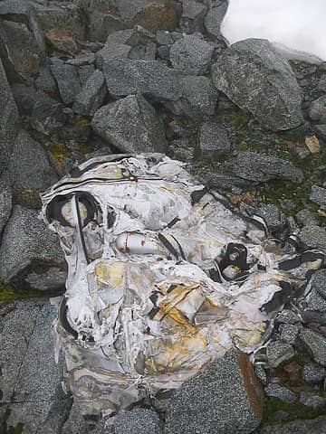 junk
|
| Back to top |
|
|
dicey
custom title

Joined: 11 May 2004
Posts: 2870 | TRs | Pics
Location: giving cornices a wider berth |
|
dicey
custom title
|
Sun Jul 17, 2005 8:56 pm |
|
|
Sounds like fun! 
|
| Back to top |
|
|
wildernessed
viewbagger

Joined: 31 Oct 2004
Posts: 9275 | TRs | Pics
Location: Wenatchee |
There are many benefits to adversity and struggle, these are great teachers. Those who have not been properly schooled are positioned to fail. Sounds like a great adventure ! 
Living in the Anthropocene
Living in the Anthropocene
|
| Back to top |
|
|
borank
Lake dork
Joined: 16 Dec 2001
Posts: 640 | TRs | Pics
Location: Evert |
|
borank
Lake dork
|
Mon Jul 18, 2005 10:58 am |
|
|
I had always wondered how a huge lake like Illabot Lk (located at the curve of the Illabot road) could shrink from 65 acres down to a size so small, you're lucky to catch a glimpse of water down through the trees from the road. That is, until I saw the outlet gorge from those pots you referred to. The whole upper Illabot basin is strewn with debris from the massive mudslide/blowout. The last lake you passed is named King Lk on 70's FS maps.
|
| Back to top |
|
|
mike
Member
Joined: 09 Jul 2004
Posts: 6398 | TRs | Pics
Location: SJIsl |
|
mike
Member
|
Mon Jul 18, 2005 12:00 pm |
|
|
| Quote: | | The whole upper Illabot basin is strewn with debris from the massive mudslide/blowout. |
Look at Slide Mtn. or Cultus Mtn. I've always wondered if the remnants of these massive slides are connected to the same event. Maybe the monster earthquake in the late 1700's? Can any of you rockheads shed any light on this?
Great trip report by the way. Epic sounds about right.
|
| Back to top |
|
|
Allison
Feckless Swooner

Joined: 17 Dec 2001
Posts: 12287 | TRs | Pics
Location: putting on my Nikes before the comet comes |
|
Allison
Feckless Swooner
|
Tue Aug 16, 2005 8:10 am question about the fisherman's trail to Boulder Lake
|
|
|
Does this trail begin from Tenas Crk Road where it hairpins across Tenas Crk, then follow the creek to Boulder Lake?
Thanks in advance,
Pat
www.allisonoutside.com
follow me on Twitter! @AllisonLWoods
www.allisonoutside.com
follow me on Twitter! @AllisonLWoods
|
| Back to top |
|
|
Guiran
Member
Joined: 03 Mar 2004
Posts: 621 | TRs | Pics
Location: University of Washington |
|
Guiran
Member
|
Tue Aug 16, 2005 8:53 am |
|
|
| Quote: | | Does this trail begin from Tenas Crk Road where it hairpins across Tenas Crk, then follow the creek to Boulder Lake? |
Yes - but the road doesn't so much hairpin as end at a wall of slide alder.
Who's Pat?
|
| Back to top |
|
|
|
|
You cannot post new topics in this forum
You cannot reply to topics in this forum
You cannot edit your posts in this forum
You cannot delete your posts in this forum
You cannot vote in polls in this forum
|
Disclosure: As an Amazon Associate NWHikers.net earns from qualifying purchases when you use our link(s). |


