| Previous :: Next Topic |
| Author |
Message |
wildernessed
viewbagger


Joined: 31 Oct 2004
Posts: 9275 | TRs | Pics
Location: Wenatchee |
Destination : Rachel, Lila, Rampart lakes and potholes, Rampart ridge, Alta Mtn. summit
Location : Rachel Lakes TH, ALW, I-90 exit 62 N > Kachess Lake Rd. > FR 4930
Guidebooks :100 Classic HIKES in Washington, 75 Scrambles in Washington
Map : Snoqualmie Pass, WA - NO 207
Roundtrip distance : 13 miles
Elevation gain : 4752'
Max. elevation : Alta Mtn. summit 6250'
Yet, Gary, Hannah, and myself met at the TH and left around 8:15 am, we had never met or hiked together (except for Hannah and I).
The initial goal was Rachel and Lila, but Alta Mtn. was a probability. The forecast was for clear and hot, maybe the hottest day of the year there yet.
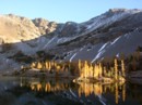
The Rachel Lakes trail was generous with it's heavy tree canopy and the trail undulated with a couple overgrown open areas until about the 2.5 mile area when you get the 1300' in a mile through a well worn and beat up trail of rocks and roots, very nice though going up, better than flat dirt, this trail showed some attitude. We passed maybe 3 slab type waterfalls running low otherwise views were scant except for hibox mtn. on occasion.
We reached Rachel Lake at 10:45 am (21/2 hours), took a short break with Yet and Gary, had some water / GU and Clif bars. Yet decided to hangout at the lake, Gary accompanied Hannah and I up to Lila lake where we all had lunch and watched the trout swimming and jumping, pumped water and I was deciding which mtn. might be Alta, I thought I saw a pyramidal pile of rocks earlier coming up but obscured. Gary decided to head back to Rachel and meet Yet and thought we would catch up with them going down as Hannah and I decided to scramble up the E slope of the ridge to it's top and see what was up with Alta.
It was a quick scramble to the ridge and a foot trail rising steadily to Alta, maybe a mile away. The rock was hot, we stayed long enough to grab some pics and share a clif bar. We then took the Rampart Ridge trail back down, it was much more inefficient than taking the easy scramble from just before the potholes before Lila Lake to the ridge, but we were heading towards Rampart lakes, losing elevation to gain a few hundred feet up to the lakes, we poked our head in there, nice, and said later, time was burning as well as skin, energy, and desire.
We decended back to Rachel pumped more water, drank a liter each of Gatorade, downed some more GU / Clif bars and headed back down. The 1300' downhill was wicked on the knees, and the 2.5 miles after that rather boring, seeming like 4-5 miles, we finally made it back to the truck at 6pm.
It was smoking at 80 degrees in the shade at the TH. Yet and Gary were long gone, they hit the TH at 4 pm. Gorgeous Lakes, deep, clear, awesome views from Alta's summit. A full featured -packed dayhike.  We each drank about 1.5 gallons of water and a liter of Gatorade. No wildlife seen. Wildflowers were scant.
http://community.webshots.com/album/413970738Suwmxy
We each drank about 1.5 gallons of water and a liter of Gatorade. No wildlife seen. Wildflowers were scant.
http://community.webshots.com/album/413970738Suwmxy
Living in the Anthropocene
Living in the Anthropocene
|
| Back to top |
  
|
|
wildernessed
viewbagger
Joined: 31 Oct 2004
Posts: 9275 | TRs | Pics
Location: Wenatchee |
If your goal was Alta Mountain for sure, I would start earlier, and to make the trip more efficient hike by Rachel to Lila Lake (s) gain the ridge from the E slope, storm the mountain follow the ridge back to Rampart Lakes, down to Rachael and back out. We meandered a little bit, but not to much. 
Living in the Anthropocene
Living in the Anthropocene
|
| Back to top |
|
|
Allison
Feckless Swooner

Joined: 17 Dec 2001
Posts: 12287 | TRs | Pics
Location: putting on my Nikes before the comet comes |
|
Allison
Feckless Swooner
|
 Fri Aug 05, 2005 12:49 pm |
|
|
| Quote: | | Destination : Rachel, Lila, Rampart lakes and potholes, Rampart ridge, Alta Mtn. summit
Location : Rachel Lakes TH, ALW, I-90 exit 62 N > Kachess Lake Rd. > FR 4930
Guidebooks :100 Classic HIKES in Washington, 75 Scrambles in Washington
Map : Snoqualmie Pass, WA - NO 207
Roundtrip distance : 13 miles
Elevation gain / loss : 4752'
Max. elevation : Alta Mtn. summit 6250' |
I'm not trying to poop in your rice bowl here, but does this mean a total elevation gain of 4752' or 2376'? It used to be that elevation gain was from low to high (major ups and down often factored in) but nowadays people add up the gain and loss and use that number, which is confusing to me. Good example, for me, a 6000' gain day would be pretty stout, 3000 up and 3000 down, not so much.
Nice trip, BTW.
www.allisonoutside.com
follow me on Twitter! @AllisonLWoods
www.allisonoutside.com
follow me on Twitter! @AllisonLWoods
|
| Back to top |
|
|
Justus S.
Member

Joined: 17 Nov 2004
Posts: 1298 | TRs | Pics
Location: WA |
Great report and pictures. Seems like a lot of people are going up to that area lately.
|
| Back to top |
|
|
wildernessed
viewbagger
Joined: 31 Oct 2004
Posts: 9275 | TRs | Pics
Location: Wenatchee |
That's the total elevation up by itself in a sommewhat linear trip, with the same down, with a loop you could have different gain and elevation, but with a in and out the loss will be equal to your gain overall. I use mapping software to more accurately get my mileage and elevation gain / loss, while gain / loss is easier to calculate and more accurate, mileage can often be off due to the closeness of switchbacks, absence of switchbacks on the map vs. reality and off trail travel. Both gain and loss were roughly 4750' for our trip / route.
Living in the Anthropocene
Living in the Anthropocene
|
| Back to top |
|
|
wildernessed
viewbagger
Joined: 31 Oct 2004
Posts: 9275 | TRs | Pics
Location: Wenatchee |
That trail looks like it gets hammered. 
Living in the Anthropocene
Living in the Anthropocene
|
| Back to top |
|
|
wbs
member
Joined: 11 Aug 2003
Posts: 661 | TRs | Pics
Location: Kirkland WA |
|
wbs
member
|
Fri Aug 05, 2005 8:24 pm |
|
|
| Quote: | | That trail looks like it gets hammered. |
What do you get when you combine that ~1300' in a mile section mentioned, the first part of the Three Fingers trail, the last grade heading up to Necklace Valley, the last grade up to Tuck Lake and the "old" cat-track style Bandera Mtn. trail into one long continuous (yet fictional) trail?
A really really hammered, really bad trail - especially in July heat 
|
| Back to top |
|
|
wildernessed
viewbagger
Joined: 31 Oct 2004
Posts: 9275 | TRs | Pics
Location: Wenatchee |
I'm not complaining the going up was better than a boring dirt path at a sub acute angle, I'd rather climb up, than walk. Coming down was tedious (the one section) and hard on the knees though. Beautiful area with alot of features and stunning views. There is definitely alot in a little area. The closer to major populations I imagine the more worn the path. We saw one person the entire day except near the end of the day by the TH two ladies were backpacking up and glad to hear they were the only ones in the whole area. 
Living in the Anthropocene
Living in the Anthropocene
|
| Back to top |
|
|
Yet
Member

Joined: 23 Apr 2005
Posts: 2634 | TRs | Pics
Location: Happily Ever After |
|
Yet
Member
|
Sat Aug 06, 2005 1:00 pm |
|
|
Rob, thank you for planning this trip.
Rachel Lake was indeed beautiful and I had a nice time napping and taking in everything while the three of you climbed some more. 
|
| Back to top |
|
|
Allison
Feckless Swooner
Joined: 17 Dec 2001
Posts: 12287 | TRs | Pics
Location: putting on my Nikes before the comet comes |
|
Allison
Feckless Swooner
|
Sat Aug 06, 2005 1:15 pm |
|
|
| Quote: | | Both gain and loss were roughly 4750' for our trip / route. |
From the Rachel Lake TH (2800') to Lila and Ramparts (appx elev 5100') and had a total GAIN of 4700'?
Now I'm really confused.... 
www.allisonoutside.com
follow me on Twitter! @AllisonLWoods
www.allisonoutside.com
follow me on Twitter! @AllisonLWoods
|
| Back to top |
|
|
wildernessed
viewbagger
Joined: 31 Oct 2004
Posts: 9275 | TRs | Pics
Location: Wenatchee |
It was very nice, and alot to take in. Glad you had a good time, Gary seemed to enjoy himself, the time slips by so quickly. I enjoyed meeting and hiking with you both and his expertise with the berries . Hannah had a funfilled day, she is quite the hiking partner.
Living in the Anthropocene
Living in the Anthropocene
|
| Back to top |
|
|
Yet
Member
Joined: 23 Apr 2005
Posts: 2634 | TRs | Pics
Location: Happily Ever After |
|
Yet
Member
|
Sat Aug 06, 2005 1:26 pm |
|
|
Yes, it was nice meeting you too!
I'm glad Hannah had fun. She didn't even seem to get tired! Please extend my regards to her also.
|
| Back to top |
|
|
wildernessed
viewbagger
Joined: 31 Oct 2004
Posts: 9275 | TRs | Pics
Location: Wenatchee |
I wouldn't ponder on it to much ML. Rachael, Lila, Potholes, Rampart Ridge, Alta Mtn, Rampart Lakes. Were not talking point A to B, or guidebook mileage and routes. It's over, time to move on.
Living in the Anthropocene
Living in the Anthropocene
|
| Back to top |
|
|
Allison
Feckless Swooner
Joined: 17 Dec 2001
Posts: 12287 | TRs | Pics
Location: putting on my Nikes before the comet comes |
|
Allison
Feckless Swooner
|
Sat Aug 06, 2005 1:45 pm |
|
|
Wow, that was not very nice. I just missed the part about summiting Alta, there's no need to bite my head off. 
www.allisonoutside.com
follow me on Twitter! @AllisonLWoods
www.allisonoutside.com
follow me on Twitter! @AllisonLWoods
|
| Back to top |
|
|
wildernessed
viewbagger
Joined: 31 Oct 2004
Posts: 9275 | TRs | Pics
Location: Wenatchee |
OK, I am sorry, then, things just aren't sometimes what they appear. Lila was the goal. Alta summit, some extra potholes, and Rampart Lakes were a series of fortunate events that happened along the way.
Living in the Anthropocene
Living in the Anthropocene
|
| Back to top |
|
|
|
|
You cannot post new topics in this forum
You cannot reply to topics in this forum
You cannot edit your posts in this forum
You cannot delete your posts in this forum
You cannot vote in polls in this forum
|
Disclosure: As an Amazon Associate NWHikers.net earns from qualifying purchases when you use our link(s). |


