Randy
Cube Rat


Joined: 18 Dec 2001
Posts: 2910 | TRs | Pics
Location: Near the Siamangs |
|
Randy
Cube Rat
|
 Mon Oct 07, 2002 9:22 pm |
|
|
Big Jim was my easy, dry side alternative as Malachite Peak was being overcome by a sea of fog and rain as I drove by about 0645 or so. Not looking for another Summit Chief kind of outing, I hurried east trying to get past the stubborn west side marine layer. Just before Coles Corner, I broke out into welcome sunshine and soon after headed up Hatchery Creek Road for 2.2 miles to my trailhead, elevation 2800'.
I left the car at 0815 and made my way up endless switchbacks to the intersection with the Badlands Trail at 5300'. I set off down the Badlands Trail which I had to take down to 4750' only to regain all that loss (and more) back up to 6000', this was my favorite part of the trip (not really). At 6000' I left the trail through moderately open forest contouring around the head of the subtle basin making up the headwaters of Battle Canyon Creek. Just before reaching the Lower Big Jim Mountain Lake I came across what looked to be an old trail that led me the last few hundred yards down to the lake. The trail was oddly placed and I was curious to see where it went back towards Hatchery Creek, but I doubted I would be coming back this direction. Anyhow, the lower lake offered up the first decent views of the mountain and the numerous routes up the east face.
I worked my way around the east side of the lake then gained a large talus field above and west of the Upper Big Jim Mountain Lake. I worked my way south to an obvious gully that brought me to the base of the subtle (and I mean subtle) east ridge of Big Jim. I ascended this ridge which goes class 2 and a couple sections of easy class 3 all the way to the top. I popped up just south of the small summit block and quickly found a warm spot to sit out of the biting wind. The summit register had been placed in October of 2001 by Fay Pullen and contained a dozen or so entries, all from 2002 except for the original. Noteworthy views included those over to Glacier peaking above the cloud tops, the entire Chiwaukum Range and most of the high points making up the Enchantments. After 45 minutes on top I descended back to the upper lake and proceeded to take a different route out.
I walked around the east side of the upper lake then contoured around the base of Point 7165' and just continued working east and ENE through easy, open forest. Several game trails made life even easier through here. I gradually dropped as I went along until hitting the creek just west of the ridge containing the trail to Lake Augusta. I had to drop 50' down a steep duff slope to just get down to the creek (about 5250' at this point) half of which was inadvertently done on my arse. After splashing into the creek, I had to get back up about 100' or so on the other side where I picked up yet another nice game trail. I contoured the hill using this trail and finally intersected the Lake Augusta trail at 5330', just a couple hundred feet from the intersection with the Badlands Trail I had used earlier in the morning. The rest of the trip out went fairly fast and I was finally back at the truck at 1615.
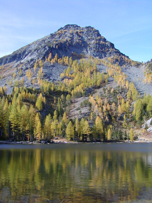 lower lake and big jim mt 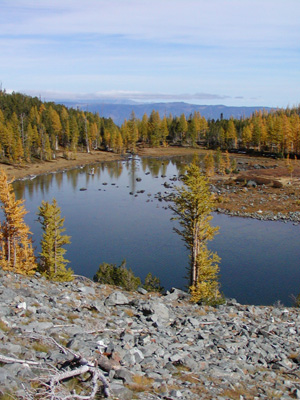 u. big jim mt lake
|


