| Previous :: Next Topic |
| Author |
Message |
rodman
Member

Joined: 03 May 2005
Posts: 49 | TRs | Pics
|
|
rodman
Member
|
 Wed Aug 10, 2005 5:25 pm |
|
|
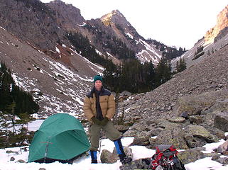
I read JimK's excellent trip report of his hike up Kaleetan on 7/17/2005 and since ragman is on vacation with his "boss" I decided to do a solo trip to Kaleentan.
The part of the hike where you leave Melakwa Lake makes the Mailbox Peak hike look like a walk in the park!
It was a very steep trail and I am glad it was very dry.
I wouldn't recommend going on this trail in damp conditions.
I took a small notebook and pencil to put in the trail register because JimK said that one was needed and he was right of course.
I need to learn how to attach my TOPO!GPS route map of this hike sometime.
|
| Back to top |
  
|
|
Jeff R
Closet hiker.

Joined: 10 Apr 2005
Posts: 972 | TRs | Pics
Location: Everret |
|
Jeff R
Closet hiker.
|
Wed Aug 10, 2005 5:52 pm |
|
|
Rodman,
Was the register still a brass can with the lid on a chain? Glad you hiked Kaleetan,it is a cool looking peak, it stands out pretty well and can be seen from around the cascades with its predominate shape, and is a fun, rewarding climb.  Do you have any pictures you would like to share?
|
| Back to top |
|
|
rodman
Member
Joined: 03 May 2005
Posts: 49 | TRs | Pics
|
|
rodman
Member
|
Wed Aug 10, 2005 8:10 pm Kaleetan Peak Trip
|
|
|
I am just trying to learn how to get my GPS routes and photos on this site.
This is a trial run to see if I am sucessfull.
|
| Back to top |
|
|
wbs
member
Joined: 11 Aug 2003
Posts: 661 | TRs | Pics
Location: Kirkland WA |
|
wbs
member
|
Wed Aug 10, 2005 8:55 pm |
|
|
Cool summit eh? Nice to see from your GPS track you (wisely) choose the south ridge route  Back in March, the low snow year prompted me to try another way than south I'd done before. Becky describes the east face route as:
"from the base of the final rise of the large talus basin to Melakwa Pass, turn left and follow a route featuring a gully and tree strip to the rocky upper S slope, then continue to summit".
Well.. I must of had the wrong gully or somthin' but the one I chose did have a layer of snow at 30 deg. + was very unstable. Near the top I triggered a 50 ft. wide slab and quickly retreated to a rock
Back in March, the low snow year prompted me to try another way than south I'd done before. Becky describes the east face route as:
"from the base of the final rise of the large talus basin to Melakwa Pass, turn left and follow a route featuring a gully and tree strip to the rocky upper S slope, then continue to summit".
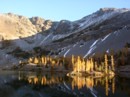
Well.. I must of had the wrong gully or somthin' but the one I chose did have a layer of snow at 30 deg. + was very unstable. Near the top I triggered a 50 ft. wide slab and quickly retreated to a rock  Scouted above to the ridge and the mossy crumble-rock didn't seem much safer. I believe the "tree strip" Becky refers to is see in this last pic as the last green vegitation strip. Scouted above to the ridge and the mossy crumble-rock didn't seem much safer. I believe the "tree strip" Becky refers to is see in this last pic as the last green vegitation strip.
 Kaleetan (east face) from Upper Melakwa Lk., March 05.
|
| Back to top |
|
|
phillyjon
Member

Joined: 15 Jul 2004
Posts: 383 | TRs | Pics
Location: White Center |
Thanx very much for the Topo.
"No matter how high one sits upon a pedestal, one still sits upon his arse." Ben Franklin
"No matter how high one sits upon a pedestal, one still sits upon his arse." Ben Franklin
|
| Back to top |
|
|
Don
Member

Joined: 25 Apr 2005
Posts: 2013 | TRs | Pics
Location: Fairwood, WA |
|
Don
Member
|
Thu Aug 11, 2005 7:51 am |
|
|
| Quote: | | Nice to see from your GPS track you (wisely) choose the south ridge route |
I can see how the south ridge would bennefit an early season ascent, but question it in late season. I climbed the south ridge and grew frustrated with all the elevation loss. I descended the east face route and found it much quicker and direct. Then again, I also got to surprise a nude sunbather at the upper lake on my way down, so maybe my judgement is clouded. 
|
| Back to top |
|
|
Guiran
Member

Joined: 03 Mar 2004
Posts: 621 | TRs | Pics
Location: University of Washington |
|
Guiran
Member
|
Thu Aug 11, 2005 8:08 am |
|
|
Route finding on the east direct route is a little more challenging, but the group I scrambled Kaleetan with was able to find a very solid (short) descent route down to the talus field. From there is was semi-stable walking down to the lakes. No nude sunbathers for us, though.
|
| Back to top |
|
|
Riverside Laker
Member

Joined: 12 Jan 2004
Posts: 2818 | TRs | Pics
|
After doing the "loop" trip last Sunday, I'd vote for the ridge route (at least this time of year). More aesthetic, far less talus to cross, and less exposure. Elevation loss is discouraging but ain't that bad. This sure is a popular peak! We signed the new booklet only days after it was placed. It'll get filled up quickly.
|
| Back to top |
|
|
|
|


