| Previous :: Next Topic |
| Author |
Message |
Tom
Admin

Joined: 15 Dec 2001
Posts: 17854 | TRs | Pics
|
|
Tom
Admin
|
 Sun Aug 14, 2005 8:21 pm |
|
|
Day 0:
Left home around 2 PM and picked up permits at the Sedro Woolley ranger station before it closed at 4:30. Dinner at DQ. Dropped Ed's truck at the Baker Lake trailhead, and car camped just before the Watson Lakes trailhead. Had a nice campfire while watching shooting stars.
Day 1:
Mike and I were roused by Ed at 8 AM who had been awake for a couple hours. After a very sluggish gear consolidation and packing session, we were finally on the trail by 10 AM. Headed cross country to Upper Anderson, then around Mt Watson, wowed by the slabs and many pools and lakes left by the receding glacier. After many picture breaks we finally reached the pass above Diobsud Lakes. While descending the steep and somewhat exposed gully to the lakes, Ed sprained his ankle quite badly. Upon reaching the uppermost lake, Mike's hamburger feet (pre-tenderized from an earlier week long trip) also needed relief, so we stopped here at around 4 PM and set up camp. The Diobsuds are nothing to write home about, but fortunately the bugs were not bad... until the next morning.
Day 2:
Awoke to lots of dew and condensation. After an hour or so of drying out in the sun, we were finally packed and on the way to Bacon Peak. Beckey's directions proved quite confusing (other than the bit about brushy ramps). The black flies multiplied exponentially as we traversed the brush in the hot morning sun, making things quite unpleasant. Upon reaching the creek we gave up on Beckey's directions and headed for the small tarns. Upon reaching the lower tarn, Mike evaluated his hamburger feet and reluctantly concluded he could not continue and would have to bail. After divvying gear, Ed and I said goodbye to Mike and continued steeply up to Bacon Peak, reaching the summit a little after 7 PM. A glance at the soggy summit register indicated we were the first to open it this year (although the last entry was undated). After leaving the register under a tin can to dry out overnight, we found a nice flat spot to camp just beneath the summit, thankful we would not have to sleep on a bed of cold snow.
Day 3:
Hastily awakened by Ed at 7 AM who indicated snow was quickly turning to slush and recommended we get going down the glacier as soon as possible. His morning recon indicated only one feasible route that might avoid significant crevasse exposure. After packing quickly we started to head down. It dawned on us that we not only forgot to sign the register but also left it out to dry. Ed offered to go back and take care of business while I snapped a few pictures. While waiting for Ed to return I noted another possible route zagging through a gully up the wall directly north. I convinced Ed to take a gamble on this route and in hindsight it may have been the only feasible route down. Crampons were still a must as some sections were quite icy, but we were able to maintain a safe distance from any visible crevasses. After a long descent, many oohs, aahs, and camera clicks we reached the meadows above Green Lake, and were rudely greeted by the swarms of black flies. Instead of dropping to the lake we decided to traverse high which would afford better picture taking opportunities. We gorged on blueberries while swatting flies, snapping pictures, and panting in sweltering heat while huffing up and down the bumps above the lake. We continued on to Nert Lake, reaching the shores by 4 PM. Exhausted from the heat, we decided to drop pack here, take a swim, and hike to the bump above the lake (hoping for views but were most disappointed). It was getting too late to continue on so we set up camp and cooked dinner, swarmed by flies. To escape the onslaught we inflated rafts and ate dinner afloat in the middle of the lake.
Day 4:
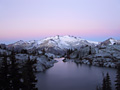
After letting things air out in the morning, we packed up and headed to Berdeen. In hindsight we probably could have made it to the large meadows below Berdeen the previous night, but noting evidence of "large" bear scat, perhaps it was better we didn't. Before the steep vegetable belay up to Berdeen we ate lunch and peeked around the corner to Lower Berdeen. It is hard to describe the feeling of standing on the shores of Berdeen, other than to say it evoked emotions deep from within. We were glad we brought rafts as the shoreline is more difficult to navigate than it would appear from photos. After a leisurely raft to the inlet we continued on to the upper lake and then the glacier that would be our exit route. Looking up to the crumbling glacier we had significant concerns about whether the route out was feasible. The only possible way seemed to be to traverse the northern edge strewn with refrigerator boulders and frequent rockfall. Sunlight was fading quickly and Ed suggested heading back to Berdeen to camp but I was concerned we would not be able to get out the next day unless we pushed on. After debating the pros and cons, we donned crampons and ice axes and briskly headed up the icy glacier, getting past the rockfall just in time to hear a fresh release come down.  Upon reaching our exit point, we breathed a huge sigh of relief and exchanged high fives. We continued on toward the summit of Blum and were relieved to find a nice flat spot to camp high on the ridge south of Blum. After feasting on our last dinner, we were enticed by a phenomenal sunset, northern lights, and the twinkle of distant city lights, staying up quite late.
Day 5:
We awoke relatively early with plans to summit Blum. It wasn't clear whether the ridge route from camp was feasible, so we opted to play it safe and descend to 5748'. From here we would dayhike the summit via Beckey's proven route. On the descent to 5748' we encountered some significant exposure and got cliffed out. On top of this, we experienced an hour of separation due to a mis-communication, and we each began to worry the other had fallen off a cliff trying to find a way down. In reality, we were not far from each other, but the cliffs were drowning out our calls. After finally hooking back up, Ed indicated he had found a way down. After reaching 5748' our desire to bag the summit waned. Throughout this trip it seemed every time we thought the worst was behind us, an even greater challenge would arise, and neither of us were in the mood for rolling the dice again after the harrowing separation. We decided to take it easy for the rest of the trip, not push our limits, and get home at a reasonable hour. After all, we would need something to look forward to next time...
As usual, I took too many pictures to cull to a reasonable number. Upon reaching our exit point, we breathed a huge sigh of relief and exchanged high fives. We continued on toward the summit of Blum and were relieved to find a nice flat spot to camp high on the ridge south of Blum. After feasting on our last dinner, we were enticed by a phenomenal sunset, northern lights, and the twinkle of distant city lights, staying up quite late.
Day 5:
We awoke relatively early with plans to summit Blum. It wasn't clear whether the ridge route from camp was feasible, so we opted to play it safe and descend to 5748'. From here we would dayhike the summit via Beckey's proven route. On the descent to 5748' we encountered some significant exposure and got cliffed out. On top of this, we experienced an hour of separation due to a mis-communication, and we each began to worry the other had fallen off a cliff trying to find a way down. In reality, we were not far from each other, but the cliffs were drowning out our calls. After finally hooking back up, Ed indicated he had found a way down. After reaching 5748' our desire to bag the summit waned. Throughout this trip it seemed every time we thought the worst was behind us, an even greater challenge would arise, and neither of us were in the mood for rolling the dice again after the harrowing separation. We decided to take it easy for the rest of the trip, not push our limits, and get home at a reasonable hour. After all, we would need something to look forward to next time...
As usual, I took too many pictures to cull to a reasonable number. 
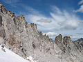
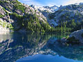
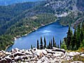
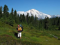 Ed Along Watson Lake Trail  Watson Lakes From Above  Upper Anderson Outlet  Upper Anderson Lake  Upper Watson From Above  Pools along Watson Traverse  Red Algae Tarn Along Watson Traverse  Looking Up To Mt Watson  Ed and Bacon Peak  Glacial Tarn Outlet on Mt Watson  Small Glacial Tarn on Mt Watson  Larger Tarn & Elementary Peak  Ice on Large Glacial Tarn  Another Glacial Tarn on Watson  Waterfall Coming Down Bacon Peak  4478' Diobsud Lake  4439' Diobsud Lake  5430' Tarns Below Bacon Peak  Looking Down to Lower Diobsuds  Unmapped Lakes at 5240' on Bacon  Electric Butte And Another Unmapped Lake  Pickets Behind Canadian Bacon (all red meat)  Shuksan Enroute To Bacon  Ed Traversing Below False Summit  360 Panorama From Bacon Peak  Snowking and Glacier Peak From Bacon  Shuksan and Eventual Route Down Up Gap  Swiss Cheeze Glacier  Berdeen and Pickets  Ed Descending Bacon  Looking Back to Route Down  Baker from Bacon  Green, Berdeen, and Pickets  Glacial Tarns at 5700'  More Green, Berdeen, and Pickets  Green Lake  Green and Bacon Laken  Waterfalls into Green  Green Lake Pano  Waterfalls Below Berdeen  Nert Lake (4556')  Lake 5354'  Green Eggs and Bacon  Ed and Green Lake Outlet  Meadow Below Berdeen  Pools Below Berdeen Outlet  Outfall into Lower Berdeen  Outfall to Lower Berdeen  Lower Berdeen  Waterfall Outlet From Berdeen  Approaching Berdeen  Berdeen Pano From Shore 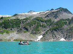 Ed Rafting Berdeen  Hagen, Lonely Peak, and Native Knoll From Raft  Berdeen From Inlet 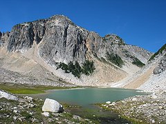 Upper Berdeen and Lonesome Peak  Meadows Above Berdeen  Berdeen Lake and Interloper Peak  Native Knoll, Interloper Peak, and Berdeen Lakes  Rockfall On Glacier Route Out  Berdeen From Ridge to Blum  Hagen At Sunset  5748' Blum From Above 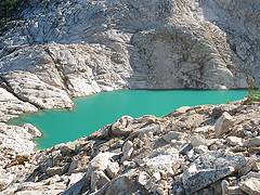 Approaching 5748' Blum  5748' Blum From Outlet  Outlet from 5748' Blum  Blum Lake From Above  Blum Lake From Outlet  Lower Blum Lake  Baker Lake From Above
|
| Back to top |
  
|
|
Tazz
Member

Joined: 27 Apr 2005
Posts: 7902 | TRs | Pics
|
|
Tazz
Member
|
Sun Aug 14, 2005 8:27 pm |
|
|
|
| Back to top |
|
|
Tom
Admin
Joined: 15 Dec 2001
Posts: 17854 | TRs | Pics
|
|
Tom
Admin
|
Sun Aug 14, 2005 8:33 pm |
|
|
Here's a few action shots complements of Ed. I'm sure he has a few more goodies.
 Looking to Avoid Crevasses  Clamps and Ice Axe  Looking Across to Baker  Rafting Berdeen  Safely Above Hagan Glacier, Phew!
|
| Back to top |
|
|
Dayhike Mike
Bad MFKer
Joined: 02 Mar 2003
Posts: 10958 | TRs | Pics
Location: Going to Tukwila |
Yep. Terrible place. Never go there.
BTW - Tom, you make it look pretty appealing. Little do they know the horror that awaits. 
"There is only one basic human right, the right to do as you damn well please. And with it comes the only basic human duty, the duty to take the consequences." -P.J. O'Rourke
"Ignorance is natural. Stupidity takes commitment." -Solomon Short
"There is only one basic human right, the right to do as you damn well please. And with it comes the only basic human duty, the duty to take the consequences." -P.J. O'Rourke
"Ignorance is natural. Stupidity takes commitment." -Solomon Short
|
| Back to top |
|
|
Trevor
Member
Joined: 31 Jan 2004
Posts: 1562 | TRs | Pics
Location: Edmonds, WA |
|
Trevor
Member
|
Sun Aug 14, 2005 8:58 pm |
|
|
I was truly anticipating this tr, thanks. A lakebagger's utopia.
|
| Back to top |
|
|
naturealbeing
Member

Joined: 05 Dec 2004
Posts: 1565 | TRs | Pics
Location: Great Mystery |
I knew this was going to happen sooner or later, I'm having a sensory system overload and it's all your fault Tom. Your lack of compassion in posting so many incredible shots at once has sent me over the top. I will probably never recover unless I experience that same trip myself.
I tip my hat to you guys, that will probably go down as the best 5 day trip of this year. Its got my vote.
If there's a better one bring it on and we will see.
BTW, I think there might be a 12 step program for people that have a compulsive picture posting disorder. I'd google it if I were you.
|
| Back to top |
|
|
wildernessed
viewbagger

Joined: 31 Oct 2004
Posts: 9275 | TRs | Pics
Location: Wenatchee |
Living in the Anthropocene
|
| Back to top |
|
|
Tom
Admin
Joined: 15 Dec 2001
Posts: 17854 | TRs | Pics
|
|
Tom
Admin
|
Sun Aug 14, 2005 9:17 pm |
|
|
| Quote: | | Tom, you make it look pretty appealing. Little do they know the horror that awaits. |
Appealing yes, but natural barriers aplenty. I don't know how many times I recited the 23rd Psalm on this trip but every time we thought we had it made we'd turn the corner and the next obstacle would await, whether it be a loose rock gully, a crevase minefield, an exposed cliff that doesn't show on the topo, an icy glacier strewn with refrigerator size boulders, a flagged boot path that vanishes abruptly in steep forest - and did I mention the black flies, the large bear scat, the absence of trees to hang food, ... 
|
| Back to top |
|
|
Kimmy
Member

Joined: 13 Jul 2005
Posts: 21 | TRs | Pics
Location: Stanwood, Wa |
|
Kimmy
Member
|
Sun Aug 14, 2005 9:36 pm |
|
|
Incredible pictures....
and I was just about to give up hiking! I want to see Berdeen!
Thanks for sharing , fantastic pics!
|
| Back to top |
|
|
Don
Member

Joined: 25 Apr 2005
Posts: 2013 | TRs | Pics
Location: Fairwood, WA |
|
Don
Member
|
Sun Aug 14, 2005 9:46 pm |
|
|
| Tom wrote: | | I took too many pictures to cull to a reasonable number. |
I am quite certain that you have proven otherwise! Fantastic job! 
|
| Back to top |
|
|
Edd
Member

Joined: 23 Jun 2003
Posts: 296 | TRs | Pics
|
|
Edd
Member
|
Sun Aug 14, 2005 10:09 pm |
|
|
Damn, nice pics Tom. Mine don't quite compare. Still don't quite have the eye for detail or composure. Learning though. Might take me awhile but I think I might be able to find one or two that you didn"t get.  Had a great time though, along with a few anxious moments that only made the trip more memorable.
Edit. Here are some pics, not nescesarially in any order. Had a great time though, along with a few anxious moments that only made the trip more memorable.
Edit. Here are some pics, not nescesarially in any order.
 shuksan  sunset from bacon  Tom skirting glacier on bacon  outlet from bacon laken 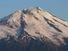 Baker close up  glacial terminus  baker sunrise  green  berdeen  the wall  bacon and green  silt contributor
|
| Back to top |
|
|
Dayhike Mike
Bad MFKer
Joined: 02 Mar 2003
Posts: 10958 | TRs | Pics
Location: Going to Tukwila |
| Kimmy wrote: | | Incredible pictures....I want to see Berdeen! |
Note that with Tom's generous delivery, you've seen more of Berdeen than most people ever have and/or ever will.  I started out on this trip with Tom and EDD and ended up having to turn back in the middle of Day 2 because my feet were still a little on the damaged side and were screaming at me something fierce.
It's some incredibly beautiful but terribly rough country and you'd be wise to allot ample time when planning a trip through it.
From the Diobsuds, for example, it took the three of us 4 hours to traverse a little over half of a mile, gaining only 200 feet from the second lake. Truly a hellacious traverse (and I got to do it *twice!*)...
I started out on this trip with Tom and EDD and ended up having to turn back in the middle of Day 2 because my feet were still a little on the damaged side and were screaming at me something fierce.
It's some incredibly beautiful but terribly rough country and you'd be wise to allot ample time when planning a trip through it.
From the Diobsuds, for example, it took the three of us 4 hours to traverse a little over half of a mile, gaining only 200 feet from the second lake. Truly a hellacious traverse (and I got to do it *twice!*)...
"There is only one basic human right, the right to do as you damn well please. And with it comes the only basic human duty, the duty to take the consequences." -P.J. O'Rourke
"Ignorance is natural. Stupidity takes commitment." -Solomon Short
"There is only one basic human right, the right to do as you damn well please. And with it comes the only basic human duty, the duty to take the consequences." -P.J. O'Rourke
"Ignorance is natural. Stupidity takes commitment." -Solomon Short
|
| Back to top |
|
|
Eric
Peak Geek

Joined: 21 Oct 2002
Posts: 2062 | TRs | Pics
Location: In Travel Status |
|
Eric
Peak Geek
|
Sun Aug 14, 2005 11:36 pm |
|
|
Lovely pics.
I wouldn't kick Berdeen outta bed or nothin but I reckon ole Green is the purtier of the two at least to my untrained eye. THat lake just looks like an unreal shade of aqua, like one of those black and white movies that Ted Turner had gone back and colorized in an over the top fashion. Lakebagger daydreams on an acid trip or something.
|
| Back to top |
|
|
sooperfly
Member

Joined: 04 May 2003
Posts: 1234 | TRs | Pics
Location: North Central Wa. |
Very nice.. looks like another place to add to the list. 
|
| Back to top |
|
|
Larry
Member

Joined: 22 Feb 2003
Posts: 1084 | TRs | Pics
Location: Kitsap |
|
Larry
Member
|
Mon Aug 15, 2005 7:47 am |
|
|
The mythical and mystical Berdeen. Simply outrageous Tom and Ed. GREAT report.
|
| Back to top |
|
|
|
|
You cannot post new topics in this forum
You cannot reply to topics in this forum
You cannot edit your posts in this forum
You cannot delete your posts in this forum
You cannot vote in polls in this forum
|
Disclosure: As an Amazon Associate NWHikers.net earns from qualifying purchases when you use our link(s). |


 very nice job guys


