| Previous :: Next Topic |
| Author |
Message |
JimK
Member


Joined: 07 Feb 2002
Posts: 5606 | TRs | Pics
Location: Ballard |
|
JimK
Member
|
 Mon Feb 20, 2006 12:08 pm |
|
|
Cold clear weather was the perfect time to get away from Seattle and go for a day of great views. Suzanne, Bob, and Kolleen joined me for a trip up to the area north of Mt. Baker. We were still undecided between Welcome Pass or snowshoeing from Mt. Baker ski area. We met at the Glacier Ranger Station at around 8:00 am and decided on Welcome Pass. We went past the road/trail and turned around at the maintenance sheds on the left. It's about 1/3 mile back to the road. There is a plowed turnout on the south side of the road where we parked. We were ready to get started just before 9:00.
The actual trailhead is 8/10 mile up the road. There is a snow berm blocking the road. Snow on the road was only a few inches deep and hard so we kept our snowshoes on our packs. The winter start at the highway begins at roughly 2000'. Welcome Pass is at 5200'. The first 8/10 mile to the summer trailhead gains 450'. The next 2 1/4 miles to the pass gains 2750'. To state the obvious, it gets steep. There were deeply postholed steps in the snow lower down. Eventually all footprints went away.
From the summer trailhead the route continued at a moderate grade. We had a few last bare spots along the trail. It was in the mid 20s at the cars but it warmed rapidly as we climbed above the valley floor. By the trailhead it was already about 30 degrees. We were able to strip down for the rest of the climb to the pass. The snow deepened and became crusty. At times it would have been nice to have brought crampons. Still, with a little care we continued higher.
In the crustiest places my concern was whether we could find our route when descending. We were able to stay on the summer route most of the way up though it was sketchy at times. Kolleen and Bob did a great job of route finding. Rock hard stretches were sometimes followed by soft snow then back to the ice again. I did not realize that forest continues all the way to the pass. I kept waiting to come out of the forest and get a look up to the pass. It never happened. We had one view across to Mt. Baker but otherwise it was dark forest all the way up.
At our viewpoint we were not pleased to see high clouds drifting in. The morning was crystal clear and I thought the whole day would be like that. We would not have blue sky to offset all the snowy peaks but it didn't turn out so bad after all. My altimeter read 5200' and still we had forest above. Either the air pressure had changed or we were climbing above the pass. We tried angling to the left in hope of finding the pass. Finally we saw light above and a little more slogging in deeper snow brought us into the open.
It turned out that we reached the ridge just to the right (east) of the pass. Now we had jaw dropping views of the peaks near the pass and to the north. Tomyhoi was not far away though it looked very different from this vantage point. It was now around noon and time for lunch. The three mile hike to the pass took us just over three hours. There are two high points on either side of the pass. Our next decision was to go east or west. Since we were already on the east side and above the pass, Point 5743 became our target.
The ridge crest was a little crusty with snowmobile tracks running along it. The snow was deep enough for us to finally put on our snowshoes. Heck, after carrying them up 3300' it was time to put them to use. The ridge is much wider than I was expecting. In places it was at least 40' wide and also very flat. We started with a steeper section that took us above the trees and finally gave us views south. Mts. Baker and Shuksan were crystal clear though backed by white clouds now. The wind was almost non existent and it was still about 30 degrees.
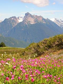
After the short steep climb the ridge turned to the north at a gentle grade. Now we could see northeast to Yellow Aster Butte, Mt. Larrabee, and the top of American Border Peak. We also had a nice close look at Goat Mountain. It looked much different from the fall hike I did there a few years back. We could see the east peak, the west peak, and the false summit where the trail ends. Point 5743 is really just a bump on the long flattish ridge. We continued to where the ridge drops off and had great 360 degree views. From there we could also see down into the Fraser River Valley in Canada.
It was now about 1:00 and time to head back. I love long ridge walks and this is one of the best winter ones I have done. I walked slow admiring the views. I was in no hurry to get back into the forest. I tried glissading the steep section but the few inches of soft snow under the crust would allow me to slide. In a few months there will be plenty of glissade opportunities. Back at our lunch spot we took off snowshoes and replaced one pole with ice axes.
The top section was snowy and plunge stepping worked great. Soon we were back into the icy crud and footing was a little more interesting. It did seem to have softened up a bit and that helped. All in all, the descent was not as bad as I feared. Nobody took a fall and where it was iciest and our boots left precious little marks we were able to stay on route. We dropped rapidly and were glad to be off the steep slope and back onto wide, albeit icy, trail. There was one stream crossing that was no problem and only a few downed trees which also presented no problems.
We finally popped out at the highway just before 3:30. We took a little over 3 hours to reach the ridge and a little under 2 hours to come down. While we did not get the bright blue skies forecast everything else was outstanding. After a winter in the Snoqualmie Pass area the North Cascades were a real treat. The ridge walk was among the best and the views from Pt. 5743 were well worth the effort. Quite a lot of effort it was. It took us about 2 1/2 hours driving time from Seattle to the trailhead. Great views, a challenging route with the ice, and great company made for a memorable day. I hope I have another trip this good this winter.
All 35 photos are now posted at: Welcome Pass Photos
Here are a few:
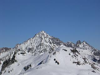
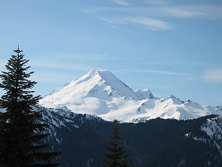 Mt. Baker 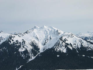 Goat Mountain 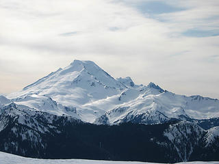 Mt. Baker
|
| Back to top |
  
|
|
Hiker Boy
Hinking Fool

Joined: 18 Feb 2002
Posts: 1569 | TRs | Pics
Location: Northern Polar Icecap |
|
Hiker Boy
Hinking Fool
|
Mon Feb 20, 2006 2:17 pm |
|
|
A very enjoyable and inspiring read. I'm going to have to try this one next month. 
|
| Back to top |
|
|
TrailPair
Member

Joined: 17 Apr 2005
Posts: 1699 | TRs | Pics
|
This thing called work is interfering with my play
|
| Back to top |
|
|
JimK
Member
Joined: 07 Feb 2002
Posts: 5606 | TRs | Pics
Location: Ballard |
|
JimK
Member
|
Mon Feb 20, 2006 9:42 pm |
|
|
|
| Back to top |
|
|
dicey
custom title

Joined: 11 May 2004
Posts: 2870 | TRs | Pics
Location: giving cornices a wider berth |
|
dicey
custom title
|
Tue Feb 21, 2006 12:13 am |
|
|
Nice!
Looks like you chose the same option from the pass some folks and I chose a couple of months ago. We didn't see any sleds either, but plenty of their tracks.
 Larrabee and YAB with snowsled tracks 12-17-05 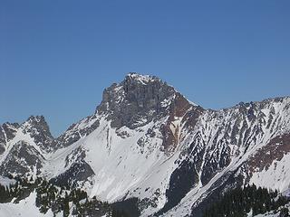 American border peak 12-17-05 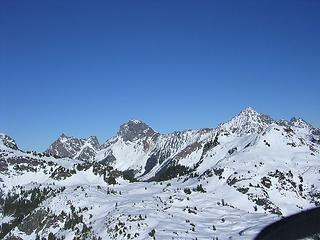 welcome pass/YAB area 12-17-05
|
| Back to top |
|
|
naturealbeing
Member

Joined: 05 Dec 2004
Posts: 1565 | TRs | Pics
Location: Great Mystery |
Wow Jim, you and your group are getting your fair share of winter trips. Glad that you were able to get a full dose of Welcome Pass, sure is purdy up there.
Us folks and dicey were blessed with great conditions and the antics of Jeff displaying a new technic for getting into snowshoes. Jeff couldn't find a rocket at the top of a antenna to take off from so this had to suffice.
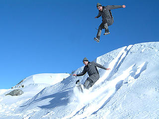 Jeff showing us how to properly jump into snowshoes. 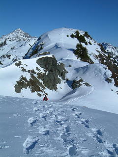 Point 5933 NW of Welcome Pass as seen from near point 5743. 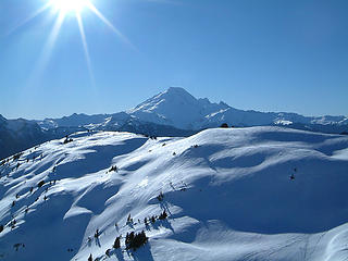 Mt. Baker as seen from near Point 5933 (NW of Welcome Pass).
|
| Back to top |
|
|
Trevor
Member

Joined: 31 Jan 2004
Posts: 1562 | TRs | Pics
Location: Edmonds, WA |
|
Trevor
Member
|
Wed Feb 22, 2006 6:26 pm |
|
|
Very nice to see baker! Nice pics guys. I particularly like the sun-star image, NB.
|
| Back to top |
|
|
Hiker Boy
Hinking Fool
Joined: 18 Feb 2002
Posts: 1569 | TRs | Pics
Location: Northern Polar Icecap |
|
Hiker Boy
Hinking Fool
|
Wed Feb 22, 2006 6:28 pm |
|
|
Looks like there are some great winter camping possibilities up there.
|
| Back to top |
|
|
Stefan
Member

Joined: 17 Dec 2001
Posts: 5091 | TRs | Pics
|
|
Stefan
Member
|
Wed Feb 22, 2006 6:47 pm |
|
|
|
| Back to top |
|
|
JimK
Member
Joined: 07 Feb 2002
Posts: 5606 | TRs | Pics
Location: Ballard |
|
JimK
Member
|
Wed Feb 22, 2006 8:23 pm |
|
|
NB,
I'm surprised to see Jeff kept his shirt on for such a sunny day.
HB,
The climb is short and steep. If you did carry a tent up there are numerous places to roam.
Stefan,
Thanks for the inspiration and great pictures back in December.
|
| Back to top |
|
|
peppersteak'n'ale
Member
Joined: 28 Aug 2003
Posts: 1996 | TRs | Pics
|
I'll be back up there again this summer  ..................whatta place ..................whatta place 
 Welcome Pass 221
|
| Back to top |
|
|
Slugman
Its a Slugfest!
Joined: 27 Mar 2003
Posts: 16874 | TRs | Pics
|
|
Slugman
Its a Slugfest!
|
Thu Feb 23, 2006 9:23 am |
|
|
After reading this trip report, I checked out the area on TOPO! It seems that a really good summer dayhike or short backpack would be to start at the Damfino Lakes trailhead (4,200 ft) and hike up to Excelsior Pass, just over 2 miles and 1,200 VF, then run the ridge over to Welcome Pass. Compared to starting at the Welcome pass end (2,400 ft) and going over to Excelsior, the Damfino start saves a full 1,800 ft of gain. With a car parked at each end, it would be a dayhike of about 11 miles and 3,000 VF up and 4,800 VF down. I've added it to my 2006 list. 
|
| Back to top |
|
|
David¹
Token Canadian

Joined: 25 Jul 2002
Posts: 3040 | TRs | Pics
Location: The Great White North |
|
David¹
Token Canadian
|
Thu Feb 23, 2006 10:03 am |
|
|
Sluggo - you can also keep going on to Yellow Aster Butte on an obvious but 'unofficial trail'
|
| Back to top |
|
|
hermes
Member

Joined: 24 Feb 2005
Posts: 449 | TRs | Pics
|
|
hermes
Member
|
Thu Feb 23, 2006 2:42 pm |
|
|
Sluggo, I did exactly that last summer - up to Excelsior from Damfino TH, along the ridge (stunning views) to Welcome - overnighted there and then hiked on until steep snow on the first downhill segment on the way to YAB stopped me. Hiked all the way out same day in rain so heavy that I didn't need to carry water!
Never dreamed that one could get up there at this time of year - truly awesome adventuring JimK! Gotta try it though it's going to take awhile for this snow to settle.
|
| Back to top |
|
|
Slugman
Its a Slugfest!

Joined: 27 Mar 2003
Posts: 16874 | TRs | Pics
|
|
Slugman
Its a Slugfest!
|
Thu Feb 23, 2006 8:49 pm |
|
|
D&K: that's a much better ending (to go on to YAB) than to just drop and drop down to the Welcome TH. Thanks.
Hermes: I agree about the "truly awesome adventuring" by JimK and company. It never ceases to amaze how some of the more intrepid members of this board go places in the middle of winter that I would consider difficult under ideal conditions. It's inspiring.
|
| Back to top |
|
|
|
|


 route up through the trees. As you are meandering through the trees wondering what happened to the trail....head for the light. When you pop out of the trees, you will be rewarded with jaw dropping scenery!!!


