| Previous :: Next Topic |
| Author |
Message |
polarbear
Member


Joined: 16 Dec 2001
Posts: 3680 | TRs | Pics
Location: Snow Lake hide-away |
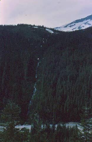
Does anyone know where this photo might have been take. I believe it is local, like I-90 or hwy 2. The scan is a bit fuzzy. There is a river at the bottom and a waterfall going down the slope.
 what mountain
|
| Back to top |
  
|
|
Tom
Admin
Joined: 15 Dec 2001
Posts: 17854 | TRs | Pics
|
|
Tom
Admin
|
 Thu Dec 26, 2002 7:37 pm |
|
|
Where did you get the photo from?
|
| Back to top |
|
|
polarbear
Member

Joined: 16 Dec 2001
Posts: 3680 | TRs | Pics
Location: Snow Lake hide-away |
It's a slide my dad took probably in the late 1960's from a road.
|
| Back to top |
|
|
Stefan
Member

Joined: 17 Dec 2001
Posts: 5093 | TRs | Pics
|
|
Stefan
Member
|
Thu Dec 26, 2002 9:17 pm |
|
|
I think it's behind Showgirls off of I-90.
|
| Back to top |
|
|
Mike Collins
Member

Joined: 18 Dec 2001
Posts: 3097 | TRs | Pics
|
I know it isn't behind Deja Vu in north Seattle.
|
| Back to top |
|
|
IBEX
Member
Joined: 02 Jan 2002
Posts: 117 | TRs | Pics
Location: IBEX Lair - Cavalero Hill |
|
IBEX
Member
|
Thu Dec 26, 2002 9:52 pm |
|
|
IBEX I-nalysis
- The snow covered slope above is angled typical of a volcanic cleaver.
- The cornice is shadowed toward the lens; probably a view looking west.
- Ridge top looks recently clear cut; that rules out Rainier.
- The rivers color hints of glacial till; Milky glacial fed.
- The river course flows straight; again typical of soft volcanic debris.
- A slight hint of a road this side of the river.
- Vegetation suggests Cascade west slope climate.
And I have know idea!  Find another slide with the same date.
"....what is above knows what is below, but what is below does not know what is above. One climbs, one sees. One descends, one sees no longer, but one has seen...." -Rene Daumel
"....what is above knows what is below, but what is below does not know what is above. One climbs, one sees. One descends, one sees no longer, but one has seen...." -Rene Daumel
|
| Back to top |
|
|
polarbear
Member
Joined: 16 Dec 2001
Posts: 3680 | TRs | Pics
Location: Snow Lake hide-away |
...or the Liberty Lasses by Blewett Pass. In the slide itself you can actually see the ladies but my $50 scanner seems to filter them into pine trees and naturey collage. Yes....it does. Sorry about that. You're battling technology here. 
|
| Back to top |
|
|
polarbear
Member
Joined: 16 Dec 2001
Posts: 3680 | TRs | Pics
Location: Snow Lake hide-away |
Thanks for the Ibexpert analysis Ibex.
|
| Back to top |
|
|
Sore Feet
Member

Joined: 16 Dec 2001
Posts: 6307 | TRs | Pics
Location: Out There, Somewhere |
Well, it could certainly be northwest, but I know few roadside rivers around these parts that are that colored. I'd be inclined to say it's somewhere in BC.
|
| Back to top |
|
|
Newt
Short Timer
Joined: 21 Dec 2001
Posts: 3176 | TRs | Pics
Location: Down the road and around the corner |
|
Newt
Short Timer
|
Fri Dec 27, 2002 8:03 am |
|
|
It reminds me of the route between Chilliwack and Hedley BC.
Just a wild guess
NN 
It's pretty safe to say that if we take all of man kinds accumulated knowledge, we still don't know everything. So, I hope you understand why I don't believe you know everything. But then again, maybe you do.
It's pretty safe to say that if we take all of man kinds accumulated knowledge, we still don't know everything. So, I hope you understand why I don't believe you know everything. But then again, maybe you do.
|
| Back to top |
|
|
Sore Feet
Member
Joined: 16 Dec 2001
Posts: 6307 | TRs | Pics
Location: Out There, Somewhere |
Could be. The snowy peak bit looks like it could be a piece of Cheam. But the river is in the wrong place for that to be true (plus, the Frazier isn't that color). I'd say possibly the Squamish / Elaho River valley with a chunk of the Tantalus Range in the background.
|
| Back to top |
|
|
Newt
Short Timer
Joined: 21 Dec 2001
Posts: 3176 | TRs | Pics
Location: Down the road and around the corner |
|
Newt
Short Timer
|
Fri Dec 27, 2002 3:57 pm |
|
|
hmmmm. I'll have to dig out the non-digital and see what I have.
Have these?
NN
It's pretty safe to say that if we take all of man kinds accumulated knowledge, we still don't know everything. So, I hope you understand why I don't believe you know everything. But then again, maybe you do.
It's pretty safe to say that if we take all of man kinds accumulated knowledge, we still don't know everything. So, I hope you understand why I don't believe you know everything. But then again, maybe you do.
|
| Back to top |
|
|
Sore Feet
Member
Joined: 16 Dec 2001
Posts: 6307 | TRs | Pics
Location: Out There, Somewhere |
The first two look pretty temporary to me. The last one is Bijoux Falls up somewhere around Monkman PP (no map in front of me, so I may be a little off, but it's somewhere north of Wells Gray). Nice pics.
|
| Back to top |
|
|
Stang
Guest
|
|
Stang
Guest
|
Wed Jan 01, 2003 1:53 am |
|
|
It could be on Camaino Island or it could be at the mustang ranch in Nevada, in any case, I like the brushy patches.
|
| Back to top |

|
|
|
|


