| Previous :: Next Topic |
| Author |
Message |
Jeff R
Closet hiker.


Joined: 10 Apr 2005
Posts: 972 | TRs | Pics
Location: Everret |
|
Jeff R
Closet hiker.
|
 Fri May 19, 2006 8:58 am |
|
|
Scott peak- 5288' Hubbart peak-5963'
Route-SouthWest Ridge - Stevens pass CAG page 59
Round trip time-13 1/2 hours - Elevation gain- 7500'
Party- Jeff R, Stefan F
Driving the Index/Galena road past the Silver Creek turn off and over the bridge brought us to a parking area next to the swollen Skykomish river. There is piles of gravel at the parking area and a barricade in the road saying the road was closed.
We walked an old road that quickly turned to a boot path that brought us to a creek and washout. On the East side of the creek we proceeded up the steep brushy forest gaining elevation quickly. The woods were still holding the heat from the day before and it was very warm and it was only 6:30 in the morning. This was a sure sign of how hot is was going to be all day long. Around 3200 feet we gained the SW ridge and this was sharply defined and very pleasant to boot up with openings in the forest allowing for some views of Mineral butte and Spire Mtn. There are some different colored tags nailed to some trees for some reason. At 4400' the snow pack became consistent and we dropped off the ridge to avoid some rock outcroppings and took a snowy bench to our left. This brought us to the final part of the West ridge which we scrambled up going over cornices, rocks, and scrub trees. In most areas it was pretty exposed and it felt good knowing we had a rope for the way down. Making the top of Scott peak by 9:30 we took in the views and found the register which there was only a couple entries on two tattered pieces of paper and the register is badly in need of a replacement.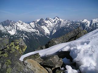 View from Scott 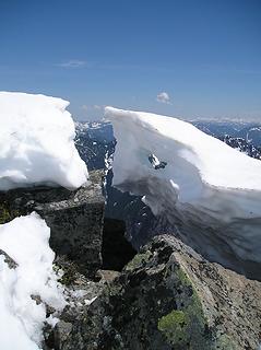 Scott, Hubbart 017 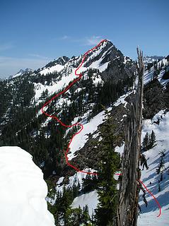 Route to Hubbart 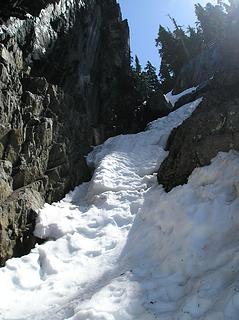 Gully to Hubbart 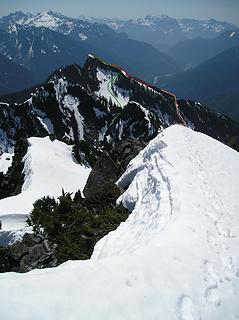 Route up,down Scott 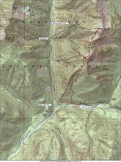 ScottHubbart
|
| Back to top |
  
|
|
wildernessed
viewbagger

Joined: 31 Oct 2004
Posts: 9275 | TRs | Pics
Location: Wenatchee |
Living in the Anthropocene
|
| Back to top |
|
|
Jamin Smitchger
Member

Joined: 02 Oct 2004
Posts: 673 | TRs | Pics
Location: Pullman |
Did Hubbart in late 2004. It really is a seldom climbed peak. Did anyone climb it last year. I am pretty sure it has only about 25 ascents to its record. 
|
| Back to top |
|
|
Stefan
Member

Joined: 17 Dec 2001
Posts: 5091 | TRs | Pics
|
|
Stefan
Member
|
Fri May 19, 2006 12:11 pm |
|
|
Great write up Jeff!
I was reading past reports and Mike T. in his report said they traversed west under point 5160 at 4500 feet. But I remember looking at that area and it did not look good. It might have went. But for future people if you do not know where the 4500 traverse point is at, here is a good description I came up with: At the point of where two streams meet (the further south one may be dry in late season) with the northern one being the main gulch, be about 50 feet higher where the two meet. You will see multiple trees on this cliff like barrier. You will have to do Tarzan moves up this section. If you are going from Hubbart to Scott, traverse at 4800 feet and then follow the gulch down until you come to your first tree and rappel into the gulch--you will not find a suitable way down to cross this gulch until you reach an elevation of 3700 feet further down.
To continue on to Scott from Hubbart, you can do two things: 1)traverse high into the north bowl of Scott and do low 5th climbing with branches and trees to gain the NW ridgeline at 5100+, or 2) traverse down to 4300 to regain the NW ridgeline of Scott at 4600+ through a gully. This option is good in the spring with snow.
|
| Back to top |
|
|
Justus S.
Member
Joined: 17 Nov 2004
Posts: 1298 | TRs | Pics
Location: WA |
Great trip report guys. Just a quick question. Would you think it's a good idea for someone(me) to solo Scott later in the year? Should I bring my short rope for the down climb? Thanks again guys. 
|
| Back to top |
|
|
Jeff R
Closet hiker.

Joined: 10 Apr 2005
Posts: 972 | TRs | Pics
Location: Everret |
|
Jeff R
Closet hiker.
|
Fri May 19, 2006 4:09 pm |
|
|
| Justus S. wrote: | | Great trip report guys. Just a quick question. Would you think it's a good idea for someone(me) to solo Scott later in the year? Should I bring my short rope for the down climb? Thanks again guys. |
Although I don't know what is under the snow pack that we travelled over entails but I would say its easily with in your skill level. You can either take the last part of the ridge in its entirety then when leaving do a rappel from a small tree with slings directly below the summit. Or, while climbing up, further below the summit you can drop to your right and scramble up solid rock to the aforementioned tree to avoid most of the exposed ridge.
Note- We did use a 50 meter rope.
|
| Back to top |
|
|
|
|


