| Previous :: Next Topic |
| Author |
Message |
Dean
(aka CascadeHiker)


Joined: 02 Mar 2002
Posts: 1967 | TRs | Pics
Location: ex Kennewick, Wa & Lehi Utah |
|
Dean
(aka CascadeHiker)
|
 Thu Jun 22, 2006 8:09 am |
|
|
Can anyone tell me if there is a trail or good route up to Natapoc Mountain The topo doesn't indicate a trail but I'd like to avoid a brushfest if possible. It looks like a decent line would be from Coles Corner but I'm hoping someone here will know this mountain and the best way to do it. Thanks.
|
| Back to top |
  
|
|
Get Out and Go
Member

Joined: 13 Nov 2004
Posts: 2128 | TRs | Pics
Location: Leavenworth |
I thought there was actually a gated road up to the top to access a microwave tower. I could be wrong (won't be the first time.  ) )
"These are the places you will find me hiding'...These are the places I will always go."
(Down in the Valley by The Head and The Heart)
"Sometimes you're happy. Sometimes you cry.
Half of me is ocean. Half of me is sky."
(Thanks, Tom Petty)
"These are the places you will find me hiding'...These are the places I will always go."
(Down in the Valley by The Head and The Heart)
"Sometimes you're happy. Sometimes you cry.
Half of me is ocean. Half of me is sky."
(Thanks, Tom Petty)
|
| Back to top |
|
|
greg
Member

Joined: 23 Jun 2003
Posts: 1159 | TRs | Pics
|
|
greg
Member
|
Thu Jun 22, 2006 8:26 am |
|
|
Dean, there are trails all over Natapoc, used mostly by local horseriders, but you can drive all the way to the top on logging roads via River Road. FS has been logging and thinning heavily up there in the last two years. I went 'shrooming up on Natapoc last month, but don't know about approaches from the Coles Corner side.
|
| Back to top |
|
|
Dean
(aka CascadeHiker)
Joined: 02 Mar 2002
Posts: 1967 | TRs | Pics
Location: ex Kennewick, Wa & Lehi Utah |
|
Dean
(aka CascadeHiker)
|
Thu Jun 22, 2006 8:43 am |
|
|
Thanks guys, that helps. 
|
| Back to top |
|
|
Stefan
Member

Joined: 17 Dec 2001
Posts: 5093 | TRs | Pics
|
|
Stefan
Member
|
Thu Jun 22, 2006 10:53 am |
|
|
Um...there are no roads to the top of Natapoc. They come somewhat close...but not to the top. I have been there. There are trails around there too, but none to the top that I recall.
|
| Back to top |
|
|
Riverside Laker
Member

Joined: 12 Jan 2004
Posts: 2818 | TRs | Pics
|
It works as a snowshoe trip.
|
| Back to top |
|
|
greg
Member
Joined: 23 Jun 2003
Posts: 1159 | TRs | Pics
|
|
greg
Member
|
Thu Jun 22, 2006 11:10 am |
|
|
I stand corrected. There are roads all over the top of Natapoc Ridge, but not to the top of Natapoc Mountain (4,204).
|
| Back to top |
|
|
aestivate
Member
Joined: 19 Mar 2004
Posts: 199 | TRs | Pics
|
| CscdHkr (Dean) wrote: | | Can anyone tell me if there is a trail or good route up to Natapoc Mountain The topo doesn't indicate a trail but I'd like to avoid a brushfest if possible. It looks like a decent line would be from Coles Corner but I'm hoping someone here will know this mountain and the best way to do it. Thanks. |
I have walked up it from the N, from the power line. In the woods all the way until you hit the ridgeline. No trail, easy.
The open ridges to the S are much more scenic, if a little lower.
|
| Back to top |
|
|
Dean
(aka CascadeHiker)
Joined: 02 Mar 2002
Posts: 1967 | TRs | Pics
Location: ex Kennewick, Wa & Lehi Utah |
|
Dean
(aka CascadeHiker)
|
Sat Jun 24, 2006 9:24 pm |
|
|
Well, Bob (smmslt) and I did Natapoc today. We parked on a road on the east side near a gated road (locked) at 2200 feet that serviced the powerlines and walked up to the 2900 foot level where we went cross country (nasty) up to the ridge on the northside. Near the top we found a trail that was coming up the ridge from the north and we happily followed it
down when we left the summit. Some outstanding views of Glacier Peak and other peaks showing a lot of snow is still present on the peaks to the west.
A hot day for sure but Natapoc was a treasure trove of Lupine flowers which were everywhere and filled the air with their wonderful scent.
Thanks to all who offered information on this peak.
|
| Back to top |
|
|
Dean
(aka CascadeHiker)
Joined: 02 Mar 2002
Posts: 1967 | TRs | Pics
Location: ex Kennewick, Wa & Lehi Utah |
|
Dean
(aka CascadeHiker)
|
Mon Jun 26, 2006 7:33 am |
|
|
Since I've received a query as to the way we went, I made up this map thanks to National Geographic's Topo program.
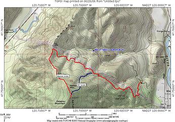 Natapoc
|
| Back to top |
|
|
Steve Erickson
Member
Joined: 13 Jun 2005
Posts: 210 | TRs | Pics
Location: Next door to my neighbors |
Years ago I parked under the railroad overpass that crosses Hwy. 2 a short ways past Coles Corner. On the north side of the highway you will see a pullout that allows you to park off the highway. It is quite brushy but head up the ridge a short ways until you break out of the brush and scramble up to the saddle. If you head to your left slightly as you start through the brush you should be able to get into the open quickly. Once at the top of the ridge remember the starting point of your hike as you don't want to miss the way back down. From the saddle I headed to my left, probably a northwest direction but I don't have my map with me to verify that. Use the drop off of the ridge on your right as a handrail going up. Soon you will meet up with an old logging road and use that as a trail as you hike up. It is relatively easy hiking and you should be able to get glimpses of Natapoc as you figure out your way up. I have hiked up into this area twice but it has been a few years. It was quite a surprise to run into an old road as none of the maps I have show it. It is probably atleast 40-50 years old. It makes for a fun scramble and really is not that brushy.
|
| Back to top |
|
|
Steve Erickson
Member
Joined: 13 Jun 2005
Posts: 210 | TRs | Pics
Location: Next door to my neighbors |
Correction - Right when you start up, after you leave your car, head a little to your right as you work your way up the brush. You will come to a steep open area very soon that you can hike up to the saddle. It takes only about 5-10 minutes of brush work to get to the steep open area.
|
| Back to top |
|
|
Dean
(aka CascadeHiker)
Joined: 02 Mar 2002
Posts: 1967 | TRs | Pics
Location: ex Kennewick, Wa & Lehi Utah |
|
Dean
(aka CascadeHiker)
|
Tue Jun 27, 2006 6:19 am |
|
|
Steve, I had considered a route very similar to what you have described originally. If I were to do this one again, your way might be the way I'd like to try. The summit of this peak is totally forested, and here's a couple pics from the trail on the north ridge.
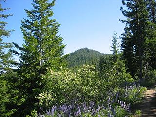 Natapoc Mtn from the north ridge trail 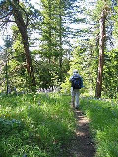 The trail on the north ridge
|
| Back to top |
|
|
Eric
Peak Geek

Joined: 21 Oct 2002
Posts: 2062 | TRs | Pics
Location: In Travel Status |
|
Eric
Peak Geek
|
Thu Oct 26, 2006 10:35 pm |
|
|
Just a couple of quick tips for anyone who might do this peak someday after today's outing:
1)If you look at the map the easy way to do this peak appeared to me to go the way Dean suggested via that 2600 ft junction to the North of the powerline road. In reality, I never found the road from Road 6601 and wound up coming in from a bit farther NE. I did try that path on the way back and would recommend against it. I wound up walking next to the road as there was more underbrush on the road than in the forest itself for most of the way. If you do wish to take this road look for a pink flag on the left side of the road right in a spot where the road bends to the right. You will not see the road even if you are five feet from it. Just walk into the forest and look for the flatest ground and follow the flat grade. The whole area to the North area is laced with abandoned roads, some appear to have been abandoned quite a while ago.
I didn't follow the powerline road the whole way down but it was in real good shape from the ridgeline down to where I veered off. Combine that with a good trail heading South from where the powerlines gain the ridge and this is the easiest way to do the peak I suspect.
2)Having said that, zzzzzzzzzzzzzt powerlines are not much fun. I'd do this in winter and take a direct line in the snow if I were to do it again.
3)For what it is worth, my GPS claimed that the Southern 4200+ summit was about 15 feet higher than the 4204 Northern summit. Too forested to see either summit from the other. Marginal bootpath but easy open forest between the two.
|
| Back to top |
|
|
|
|


