| Previous :: Next Topic |
| Author |
Message |
ragman and rodman
Member


Joined: 28 Apr 2005
Posts: 1219 | TRs | Pics
Location: http://rgervin.com/ |
Trailhead: From the 29 Pines Campground drive the North Fork Teanaway road for 8 miles to the DeRoux Horse Camp
continue a short distance beyond the horse camp and turn left on a signed road
after a quarter mile on this side road you will find the trailhead (3800 feet) and DeRoux campground
do not confuse the horse camp with the campground/trailhead.
Rodman rested today so I joined Charlie, a good friend from college, for this adventure
Lordy!, lordy!, we were so much younger then
our hiking motto in college was 15 more years
its been 30 years now and we are going to stick with the motto as long as possible.
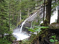
Route: Shortly after beginning the hike on trail #1392 cross De Roux creek on a good bridge and in 1.5 miles reach a junction with trail #1392.1
stay to the right at this junction and continue on #1392 for another 2.5 miles which takes you within an eighth of a mile of Gallagher Head Lake (5600 feet)
here we started an upwardly biased traverse to the west as we rounded the eastern end of Hawkins Mtn
the traverse brought us to 6200 feet where we could see our route to the saddle between the east and west summits of Hawkins
at this point the route becomes more steep so we went to the ice ax and reached the saddle at 6800 feet by traveling on both snow and rock
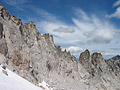
from the saddle turn left (west) and reach a false summit at 7080 feet
drop a bit and follow the ridge north for a eighth of a mile to the summit at 7160 feet.
Comments: The route is basically continuous snow from 4800 feet (2 miles from the trailhead) to the Hawkins saddle at 6800 feet
the ridge between the false summit and summit is corniced, but the cornices can be avoided by staying on west side of the ridge
there is no bridge to use for the stream crossing at 2.5 miles where knee-high gaiters were useful
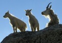
the views were spectacular
Hibox, Three Queens, Lemah, Chimney Rock, Hinman, Daniel, Summit Chief, Bears Breast, The Cradle, Ingalls, Fortune, the Stuart Range and most of the Teanaway Peaks.
Pictures of the Hawkins Mtn hike
..
|
| Back to top |
  
|
|
wildernessed
viewbagger

Joined: 31 Oct 2004
Posts: 9275 | TRs | Pics
Location: Wenatchee |
Awesome as usual, I like all the shots. The pic of the S slope of Fortune we took down last week puts that route in perspective. 
Living in the Anthropocene
Living in the Anthropocene
|
| Back to top |
|
|
rodman
Member
Joined: 03 May 2005
Posts: 49 | TRs | Pics
|
|
rodman
Member
|
 Thu Jun 22, 2006 5:07 pm |
|
|
Ragman was correct I was "resting" to get ready for a big three day weekend in the outdoors.
Meanwhile, here is a copy of our GPS rote up Hawkins Mountain that we did together in October of 2003.
|
| Back to top |
|
|
Randy
Cube Rat

Joined: 18 Dec 2001
Posts: 2910 | TRs | Pics
Location: Near the Siamangs |
|
Randy
Cube Rat
|
Thu Jun 22, 2006 5:57 pm |
|
|
Cool. Did you guys scramble The Thimble? Makes for a nice little side trip while up there.
|
| Back to top |
|
|
ragman and rodman
Member
Joined: 28 Apr 2005
Posts: 1219 | TRs | Pics
Location: http://rgervin.com/ |
Randy... we did not do the Thimble... I assume that it is one of the lumps in my third picture... Becky's book says that there is some Class 4 on it... if accurate, that kind of puts it out of my league...
|
| Back to top |
|
|
Randy
Cube Rat
Joined: 18 Dec 2001
Posts: 2910 | TRs | Pics
Location: Near the Siamangs |
|
Randy
Cube Rat
|
Thu Jun 22, 2006 9:30 pm |
|
|
Yeah, it's the high point ESE of Hawkins at the end of the ridge formation. Class 3 with a 6' slab that you have to butt slide down.
|
| Back to top |
|
|
mtnmschist
Member

Joined: 13 Jun 2006
Posts: 26 | TRs | Pics
Location: Seattle/Greenlake |
hey, where exactly is this hike? i see your directions but i dont know what area its in. about how long is the hike? technicality? how hard is it to make your way?
|
| Back to top |
|
|
ragman and rodman
Member
Joined: 28 Apr 2005
Posts: 1219 | TRs | Pics
Location: http://rgervin.com/ |
mtnmschrist... the hike is in the Teanaway... from exit 85 on I-90 take highway 970 (it might be highway 97) which goes to Blewett Pass and Leavenworth; however, you don't go all the way to Blewett Pass... you only drive hwy 97 for 7-10 miles... when you start to see the top of Mt. Stuart on your left, you are getting close to the left turn onto The Teanaway River road... drive the road for maybe 10 miles... you will pass a small convenience store on the right (there is only one such store on this road)... the road goes around a corner where you can turn left on the West Fork Teanaway road or continue on the North Fork Teanaway road... stay on the north fork road and you will see tall mountains up the valley... drive another 7 to 10 miles to the 29 Pines campground... then use the directions in my original post to get to the trailhead just past the De Roux horse camp...
Putz-in-Boots mentions two other routes... one via Salmon La Sac and the other via Esmerelda Basin... both of those might encounter some 4 wheel drive activity...
The hike is described in Becky's climbing book as a Class 2 "summit hike"... you might find some of the last 800 feet of elevation gain to be a little airy depending on you experience level...
Prior experience with this hike aided us with some route finding in the snow on the way to Gallagher Head lake... in two weeks I think that the snow will be gone on this hike... the downside is that the 4-wheelers will also start taking advantage of the snow-free road leading to the lake... in my opinion, the ideal time to do this hike is mid-week when the snow has already melted.
The hike was 11.5 miles round-trip... with approximately 3300 feet of elevation gain.
|
| Back to top |
|
|
Tom
Admin
Joined: 15 Dec 2001
Posts: 17851 | TRs | Pics
|
|
Tom
Admin
|
Fri Jun 23, 2006 9:42 am |
|
|
The jeep road to GH Lake is a really fun ride. I will be among those with 4WD taking advantage of it when the snow melts. Don't let that deter you in the least.
|
| Back to top |
|
|
ragman and rodman
Member
Joined: 28 Apr 2005
Posts: 1219 | TRs | Pics
Location: http://rgervin.com/ |
Definitely don't let the 4-wheelers deter you... you might even be fortunate enough to get a hot tub soak on the way out... in October 2003 some guys were pumping water from Gallagher Head Lake into the bed of their pickup and warming it up for a soak...
|
| Back to top |
|
|
Tom
Admin
Joined: 15 Dec 2001
Posts: 17851 | TRs | Pics
|
|
Tom
Admin
|
Fri Jun 23, 2006 11:09 am |
|
|
Good idea! Actually, when I was up there last year I was surprised how nice it was for a 4WD destination. A few bad apples for sure, but I suspect the majority are responsible, and someone definitely picks up the apple cores.
|
| Back to top |
|
|
ragman and rodman
Member
Joined: 28 Apr 2005
Posts: 1219 | TRs | Pics
Location: http://rgervin.com/ |
Putz... this will probably be the last weekend to glissade the south side of Hawkins... it's melting quickly in the 80 degree heat... 4-wheeling up there would make Hawkins a 2 mile round-trip hike instead of 11.5 miles via the De Roux Creek route... I'll stick to the trail route.
|
| Back to top |
|
|
Randy
Cube Rat
Joined: 18 Dec 2001
Posts: 2910 | TRs | Pics
Location: Near the Siamangs |
|
Randy
Cube Rat
|
Fri Jun 23, 2006 12:02 pm |
|
|
| Tom wrote: | | The jeep road to GH Lake is a really fun ride. I will be among those with 4WD taking advantage of it when the snow melts. Don't let that deter you in the least. |
Tom - did you continue past the lake into the basin below Hawkins? If so, how was the road back there? I remember walking it a few years ago thinking it would be a fun drive, but there were a couple decent mud holes that were questionable.
|
| Back to top |
|
|
Tom
Admin
Joined: 15 Dec 2001
Posts: 17851 | TRs | Pics
|
|
Tom
Admin
|
Fri Jun 23, 2006 12:43 pm |
|
|
Randy, we just drove to GH Lake. It was this trip last year. We didn't go to Hawkins. Apologies for the thread drift. I will walk an extra 9 miles of gated logging road to attone for my sins.
|
| Back to top |
|
|
|
|


