| Previous :: Next Topic |
| Author |
Message |
rodman
Member

Joined: 03 May 2005
Posts: 49 | TRs | Pics
|
|
rodman
Member
|
 Sat Jul 01, 2006 3:02 pm |
|
|
Ragman and Rodman decided to give the Teanaway area a rest yesterday and settled for something closer to Seattle. We decide to do Snoqualmie Mt and Guye Peak from the Alpental parking area. We encountered almost no snow and there was no problem crossing the creek at the waterfall. We reached the top of Snoqualmie in about 2.5 hours and had great all around views of Olympics, Baker, Glacier Peak, Stuart, Adams, Rainier and all the others in between!
It took us nearly 2 hours to get to the summit of Guye because some minor route finding problems on the side of Cave Ridge since most of the boot path trail was under snow. Once again great views from and we return to the parking lot in 1.25 hours. Ragman will post pictures of the hike together with the GPS route.
|
| Back to top |
  
|
|
wildernessed
viewbagger

Joined: 31 Oct 2004
Posts: 9275 | TRs | Pics
Location: Wenatchee |
I can see why you might have a little Teanaway fatigue, though it's quite nice, the crowds must be gathering, and where haven't you been there ? 
Living in the Anthropocene
Living in the Anthropocene
|
| Back to top |
|
|
ragman and rodman
Member

Joined: 28 Apr 2005
Posts: 1219 | TRs | Pics
Location: http://rgervin.com/ |
|
| Back to top |
|
|
ragman and rodman
Member
Joined: 28 Apr 2005
Posts: 1219 | TRs | Pics
Location: http://rgervin.com/ |
|
| Back to top |
|
|
mvdholst
Member

Joined: 16 May 2006
Posts: 45 | TRs | Pics
|
|
mvdholst
Member
|
Sun Jul 02, 2006 5:44 pm |
|
|
Personally, I think the GPS reports are very useful, especially for known routes. As I often hike solo, having good maps for known routes is very important to me. For instance, I find the green trails map for snoqualmie pass (no 207) lacking detail, and when I have a GPS map, it often adds the detail I want. Also, with GPS maps I can zoom in on the map at home, and check out if the route is actually ok for me to do alone.
My 2ct,
Marcel.
|
| Back to top |
|
|
Akula
Member

Joined: 04 Nov 2005
Posts: 477 | TRs | Pics
Location: Somewhere in middle America |
|
Akula
Member
|
Sun Jul 02, 2006 6:43 pm |
|
|
Excellent pictures. The shot of Rainier is outstanding
Twenty years from now you will be more disappointed by the things that you didn't do than by the ones you did do. So throw off the bowlines. Sail away from the safe harbor. Catch the trade winds in your sails. Explore, dream, discover. -- Mark Twain
Twenty years from now you will be more disappointed by the things that you didn't do than by the ones you did do. So throw off the bowlines. Sail away from the safe harbor. Catch the trade winds in your sails. Explore, dream, discover. -- Mark Twain
|
| Back to top |
|
|
Quark
Niece of Alvy Moore

Joined: 15 May 2003
Posts: 14152 | TRs | Pics
|
|
Quark
Niece of Alvy Moore
|
Sun Jul 02, 2006 9:06 pm |
|
|
One o' these days I'll have to stop being a Snoqualmie Pass snob and actually get in there & do sumpin'. I particuarly like Red Mtn; it's so - red. Why?
Nice pics.
"...Other than that, the post was more or less accurate."
Bernardo, NW Hikers' Bureau Chief of Reporting
"...Other than that, the post was more or less accurate."
Bernardo, NW Hikers' Bureau Chief of Reporting
|
| Back to top |
|
|
Malachai Constant
Member

Joined: 13 Jan 2002
Posts: 16093 | TRs | Pics
Location: Back Again Like A Bad Penny |
Because it is a choss pile of red rocks, silly 
"You do not laugh when you look at the mountains, or when you look at the sea." Lafcadio Hearn
"You do not laugh when you look at the mountains, or when you look at the sea." Lafcadio Hearn
|
| Back to top |
|
|
run4cache
Member

Joined: 18 Jun 2006
Posts: 137 | TRs | Pics
|
|
run4cache
Member
|
Mon Jul 03, 2006 4:42 pm Up there today
|
|
|
I enjoyed this scramble today. It rained a little on my way out. Conditions were good. Quite a few bugs if you stop moving.
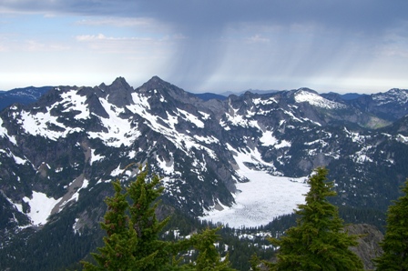 SnowLake 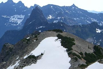 Looking East from Snoqualmie 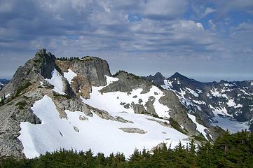 Snoqualmie Mtn
|
| Back to top |
|
|
peppersteak'n'ale
Member
Joined: 28 Aug 2003
Posts: 1996 | TRs | Pics
|
Nice pics, especially the Snow Lake shot with the rain tendrils coming out of the sky 
|
| Back to top |
|
|
lopper
off-route

Joined: 22 Jan 2002
Posts: 845 | TRs | Pics
|
|
lopper
off-route
|
Mon Jul 03, 2006 5:08 pm |
|
|
At the risk of being nitpicky, your "tooth" shot is of Lemah, Thomson and Chikamin.
The Tooth is in a more westerly direction. And quite a bit lower.
Good pics!
|
| Back to top |
|
|
rodman
Member
Joined: 03 May 2005
Posts: 49 | TRs | Pics
|
|
rodman
Member
|
Mon Jul 03, 2006 5:17 pm |
|
|
On our trip we went by a small tarn near the summit of Guye Peak. We saw two Salamanders swimming around and I got a couple of poor quality photographs.
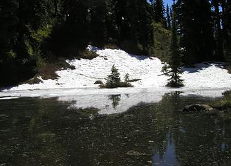 Small tarn near summit 0f Guye 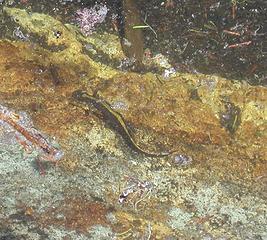 Long-Toed-Salamander-1 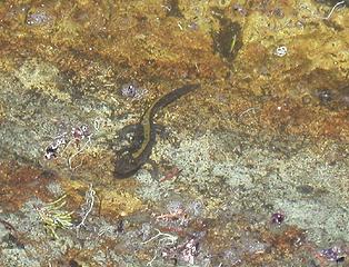 Long-Toed-Salamander 2
|
| Back to top |
|
|
run4cache
Member
Joined: 18 Jun 2006
Posts: 137 | TRs | Pics
|
Thanks for the comments on my photos. I updated the titles on them. I only saw one other hiker while out there today.
|
| Back to top |
|
|
ragman and rodman
Member
Joined: 28 Apr 2005
Posts: 1219 | TRs | Pics
Location: http://rgervin.com/ |
Looking at your picture of Mt. Snoqualmie it looks like you might have gone up and over the false summit on the left side of your photo and then up to the main summit more in the center of the photo... if so, how was the route going over the false summit?
|
| Back to top |
|
|
run4cache
Member
Joined: 18 Jun 2006
Posts: 137 | TRs | Pics
|
|
run4cache
Member
|
Mon Jul 03, 2006 10:17 pm Going over the false summit
|
|
|
Let's just say I didn't make it over the false summit. I got on top of it -- that was scarey enough. I made my way back down a ways and scrambled across the face and up to the summit. I thought my approach was a scenic, enjoyable route -- just avoid the false summit. Going back down I took the main trail and it was steep but much quicker.
|
| Back to top |
|
|
|
|


