| Previous :: Next Topic |
| Author |
Message |
cheakamus
Member


Joined: 19 Jul 2003
Posts: 331 | TRs | Pics
Location: Seattle |
We arrived at the Bare Mtn. trailhead at 8:30 a.m., after an hour-and-a-half drive from Seattle. The road was potholed, but not excessively.
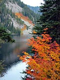
Bear River was raging. You wouldn't want to fall in, especially at the log crossing one mile in. The trail was dry and mostly brushed out all the way to the top. Some flowers, e.g., columbines, were already very much in evidence. We saw a few lupines, with the promise of many more to come. Also some early marsh marigolds, mimulas and shooting stars near the watercourses.
We set out using Justus S.'s report of 9/7/05 as a guide, with the goal of attaining Coney Lake and any intervening peak along the way. Initially, we intended to take the trail to Bear Lakes, mentioned in 100 Hikes, but missed the turnoff entirely. Instead, we stayed on the main trail until it passed just below the lowest part of the saddle between Bare Mtn. and Point 5310. There, we left the trail, crossed the saddle, and descended 100 feet or so on the other side. We then began a half-mile traverse, mostly on snow, across the northern slope of 5310 to the saddle between 5310 and 5449, looking down on Bear Lakes.
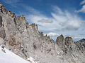
From there, we ascended across talus on the south side of 5449 till we reached the ridge between 5449 and 5706 (Canoe Peak). We had intended to stay on this ridge and eventually summit Canoe, but instead we dropped down to the snow field on the north side of the ridge and maintained a high traverse above Kanim Lake toward the next low point on the horizon, the saddle between Canoe Peak and Point 5695.
There we crossed the ridge again and proceeded on the south side for a while, hopping rocks and snow patches along the ridge. After a few hundred feet, we decided the north side look better and dropped back over for a long traverse over snow to a point just below 5695 (really, the last point were accessing the ridge seemed feasible).
Back on the ridge, we had the option of following it to the top of 5695, and thereafter Mt. Lennox (5894). Instead, we headed northeast toward what I was pretty sure must be the basin of Coney Lake. Coney has been described as looking very much like Robin Lakes, and certainly, the approach is eerily similar.
After twenty minutes along a level traverse we arrived at a ridge overlooking the lake, which was 99 percent frozen (just a bit of blue around the edges). As this was pretty much our turn-around time, we didn't ascend Lennox.
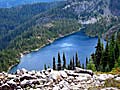
Even covered with snow, Coney is quite the jewel! It sits in an almost perfect crater, breached only by the outlet stream. On the opposite side of the rim is a small vertical peak that would be fun to try to climb once the snow is gone. I had trouble distinguishing the other peaks around, as from this angle, nothing looked familiar. Eventually, I discerned Hinman and Daniel, and then some of the others fell into place. Baker was also visible in the distance, as were The Brothers and some of the other Olympics.
On the way back, once we attained the main ridge, we dropped over to the north side and this time stayed there, going several hundred feet lower into the huge bowl above Lake Kanim and traversing all the way around the bowl on snow and back up to the saddle overlooking Bear Lakes. We then dropped down over talus to Bear Lakes and found the rudimentary boot path that descends from there to an abandoned mine and some old mining machinery (a steam donkey). We went 50 or 60 feet into the mine (hardrock) to where it appeared to turn left, but since we didn't have lights, stopped there.
After the mine, the trail becomes a little indistinct. Some steel cables leading toward the woods from the steam donkey provide a clue. Follow the cables and eventually, another sketchy path takes you to an old camp and more abandoned machinery. Again the trail becomes indistinct. After beating around a bit in the bush, we realized that the trail had in fact become an old road, complete with corduroy bridges, that more or less followed the contour of the land. We were therefore able to stay on course, despite rockfalls, slides, and encroaching vegetation, just by imagining where a road would have to go. Although Justus S.'s September '05 report states the trail is easy to follow after the mine, we found it completely grown in with waist-high bracken!
Just when the bracken was at its thickest, the road joined the main trail. The junction is much lower on the trail than we had supposed. It is at the end of a long traverse above Bear Creek, just before the trail begins switchbacking up toward Bare Mountain (approx.3400 feet elevation).
Although we didn't summit any of the peaks, we hit all the saddles, and our destinationConey Lakewas a very worthy goal in itself. I don't know if I'd want to do it later in the summer though, even with the promise of a cooling swim at the end. In another week or so, much of the snow will be gone, and getting to Coney will entail almost endless ridge scrambling or a long, hot slog across a baking talus sidehill.
|
| Back to top |
  
|
|
Sore Feet
Member

Joined: 16 Dec 2001
Posts: 6307 | TRs | Pics
Location: Out There, Somewhere |
|
| Back to top |
|
|
Backpacker Joe
Blind Hiker

Joined: 16 Dec 2001
Posts: 23956 | TRs | Pics
Location: Cle Elum |
"If destruction be our lot we must ourselves be its author and finisher. As a nation of freemen we must live through all time or die by suicide."
Abraham Lincoln
|
| Back to top |
|
|
touron
Member
Joined: 15 Sep 2003
Posts: 10293 | TRs | Pics
Location: Plymouth Rock |
|
touron
Member
|
 Mon Jun 26, 2006 11:13 pm |
|
|
Si! Si! Where is the proof! 
Touron is a nougat of Arabic origin made with almonds and honey or sugar, without which it would just not be Christmas in Spain.
Touron is a nougat of Arabic origin made with almonds and honey or sugar, without which it would just not be Christmas in Spain.
|
| Back to top |
|
|
fishonjoe
Member

Joined: 13 Feb 2006
Posts: 278 | TRs | Pics
Location: Marysville, Wa. USA |
cheakamus
Nice report...thank you
If you were to do it again, would it be easier to stay on the trail to the ridge or follow the old mine route to bear lakes on the way in. Maybe a little longer with the trail but no brush?
Thanks
fishonjoe
|
| Back to top |
|
|
Allison
Feckless Swooner

Joined: 17 Dec 2001
Posts: 12287 | TRs | Pics
Location: putting on my Nikes before the comet comes |
|
Allison
Feckless Swooner
|
Mon Jul 10, 2006 3:14 pm |
|
|
www.allisonoutside.com
follow me on Twitter! @AllisonLWoods
|
| Back to top |
|
|
Dayhike Mike
Bad MFKer
Joined: 02 Mar 2003
Posts: 10958 | TRs | Pics
Location: Going to Tukwila |
| cheakamus wrote: | | ...getting to Coney will entail almost endless ridge scrambling or a long, hot slog across a baking talus sidehill. |
Having had experienced said slog across a baking talus sidehill, I concur!  Fishonjoe, I'd bring your freeze-dried if you're visiting Coney. I wouldn't count on there being fish in there.
"There is only one basic human right, the right to do as you damn well please. And with it comes the only basic human duty, the duty to take the consequences." -P.J. O'Rourke
"Ignorance is natural. Stupidity takes commitment." -Solomon Short
"There is only one basic human right, the right to do as you damn well please. And with it comes the only basic human duty, the duty to take the consequences." -P.J. O'Rourke
"Ignorance is natural. Stupidity takes commitment." -Solomon Short
|
| Back to top |
|
|
cheakamus
Member
Joined: 19 Jul 2003
Posts: 331 | TRs | Pics
Location: Seattle |
| fishonjoe wrote: | | If you were to do it again, would it be easier to stay on the trail to the ridge or follow the old mine route to bear lakes on the way in. Maybe a little longer with the trail but no brush? |
Hard to say. First you'd have to FIND the trail to Bear Lakes (just remember to leave the main trail where the switchbacks begin and contour gently upwards until you reach the forest). This way is probably more direct, but it's a bit of a scramble, part of it up a small watercourse, until you reach the lakes. Then it's open talus to the ridgetop.
The other way, you've got a good trail almost all the way to the ridgetop, with about a half mile traverse across the backside of the ridge to where the gully up from Bear Lakes intersects the ridge.
Sounds like Coney is still frozen!
|
| Back to top |
|
|
Dayhike Mike
Bad MFKer
Joined: 02 Mar 2003
Posts: 10958 | TRs | Pics
Location: Going to Tukwila |
| cheakamus wrote: | | Sounds like Coney is still frozen! |
It is indeed.
I scoffed when Tom told me it melted out late, after all...it's at only 5100' and Colchuck at 5600' was melted out a month or more ago.
Now I've seen it and I'm a believer. Give it another month, maybe.
"There is only one basic human right, the right to do as you damn well please. And with it comes the only basic human duty, the duty to take the consequences." -P.J. O'Rourke
"Ignorance is natural. Stupidity takes commitment." -Solomon Short
"There is only one basic human right, the right to do as you damn well please. And with it comes the only basic human duty, the duty to take the consequences." -P.J. O'Rourke
"Ignorance is natural. Stupidity takes commitment." -Solomon Short
|
| Back to top |
|
|
Tom
Admin
Joined: 15 Dec 2001
Posts: 17854 | TRs | Pics
|
|
Tom
Admin
|
Mon Jul 10, 2006 9:58 pm |
|
|
Yes, still plenty frozen, see here.
|
| Back to top |
|
|
Mike M.
Member
Joined: 26 Jul 2006
Posts: 28 | TRs | Pics
|
|
Mike M.
Member
|
Wed Jul 26, 2006 7:00 pm Cony Lk
|
|
|
Another way to Coney Lk is the one I took about 35 years ago. Take abandoned W. Fork of Miller River Rd to end. Follow abandoned Jeep rd. straight uphill for about 2,000 ft. (Probably no trace of road left). This brings you to Cleopatra Basin and abandoned Cleopatra mine. Follow stream in basin to right straight up for about 800 ft. and you arrive on top with views to Bear and Paradise Lks to left and further along ridge to Lk Kanim below on left. Contour along above Coney Basin directly to Coney Lk. There are experimental steelhead trout in Coney Lk (planted by the Trailblazers) and they look like grey ghosts! I did Coney Lk in the winter one time straight up through Coney Basin on snowshoes! I am 70 years old and know every trail and high route in the central and north Cascades.
|
| Back to top |
|
|
lopper
off-route

Joined: 22 Jan 2002
Posts: 845 | TRs | Pics
|
|
lopper
off-route
|
Wed Jul 26, 2006 8:16 pm |
|
|
Welcome to the site Mike M!
Son #3 and I made an autumn recon to the cliffbands on the W side of Coney Basin about 8 years ago. Remnants of the road can be followed to the talus slopes around the mine adits, but it was extremely brushy.
After visiting Coney several times via two easier routes, I haven't been back to try the WFK Miller again. It does feature a more pleasant valley to hike up, good views, and a less tedious car approach.
And as far as snowfield travel versus the talus fields. My cohorts and I much prefer the rock gardens and slabs and moss. Step kicking across snowfields makes for fast transit, but I think you miss a lot.
|
| Back to top |
|
|
|
|
You cannot post new topics in this forum
You cannot reply to topics in this forum
You cannot edit your posts in this forum
You cannot delete your posts in this forum
You cannot vote in polls in this forum
|
Disclosure: As an Amazon Associate NWHikers.net earns from qualifying purchases when you use our link(s). |


