| Previous :: Next Topic |
| Author |
Message |
Dayhike Mike
Bad MFKer

Joined: 02 Mar 2003
Posts: 10958 | TRs | Pics
Location: Going to Tukwila |
Looks like I went a week previous to Tom and company's trip last year.
My dad was out of commission after his fall, and so I enlisted the company of a friend from work who'd always wanted to see the Enchantments. We set out on our 'day hike' on September 21st, starting from the Stuart Lake trailhead a little late, around 7am.
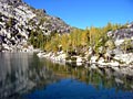
Evidence of just how dry the season had been was everywhere -- the waterfall just before Colchuck was dry and the water level in the lake was lower than I'd ever seen it before.
We spent a fair amount of time enjoying the sights around Colchuck, and dinked around in the talus at the far end of the lake, but our ascent was quick and we reached the top of Aasgard right around noon.
Beautiful weather; not a cloud in the sky, and visibility was tremendous from the top. Spent our lunch taking in Brynhild/Isolation Lake, Dragontail and Little Annapurna and then began our descent.
Talisman/Inspiration Lake was gorgeous, and Perfection/Rune begged for us to cool our feet wading in its shallow waters. The trees had just started to show their color, but hadn't yet fully turned.
Refreshed, we decided to visit Gnome Tarn and head out past Shield, Earl, and Mesa and down Toketie Creek. I began feeling a little uneasy as we dropped from Prusik Pass as the shadows were a little longer than I'd expected and my hiking buddy was starting to slow a bit.
As we rounded Mesa and crossed the hump to drop into the Toketie Creek drainage, it became more and more clear that we probably wouldn't make it out that night. The trail was sketchy at best and lack of light forced us to drag out a flashlight just to remain on course.
Crossed the outlet of Toketie and headed up over the rock to begin the 3000 foot drop to the Snow Creek floor and broke out a second flashlight to avoid tripping over the rough terrain. At 10:30pm, after dropping 1000 feet, we lost the faint trail completely and decided to call it a night.
Luckily we had decent weather, so rain and wind weren't really a problem. Unfortunately, the lack of cloud cover meant that it cooled off more than I was prepared for. Chris had brought a space blanket, so he wrapped himself in that and bought himself a little solace. I on the other hand was inadequately equipped with shorts, a t-shirt, and a polar fleece; at midnight, I was shivering uncontrollably and decided that I'd bend the rules and light a fire for warmth.
At 6am, we decided it was time to push on. Even as daylight broke, it was tough finding remnants of the trail. It had been almost 10 years since my dad and I went down this route, and the ravages of forest fire and the trampling of firefighters had apparently obliterated most of the path I'd remembered.
We stayed right as we descended, avoiding the Toketie Wall. The trail seemed to disappear in a boulder field, and reappeared on the left (north) edge. The trail seemed a bit more coherent near the bottom of the slope, but it was still heavily trampled and left a loose, sandy, slick and poorly defined route, rather than the decent route I remembered.
When we reached the bottom, we crossed the river and headed down the regular trail to the Snow Creek parking lot. Ascended to the lot a little stiff, a little sore, and looking forward to a long hot shower, and were welcomed home by the nice Chelan County Sheriff who'd been called out to look for us. 
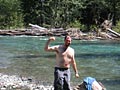
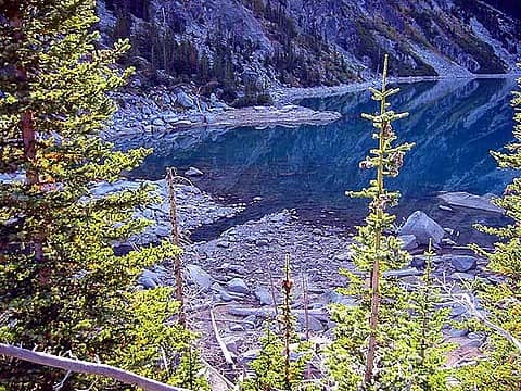 I've never seen the water this low in all the years I've been up here. There's more of the lake out of view to the left; these rocks are all usually totally submerged. 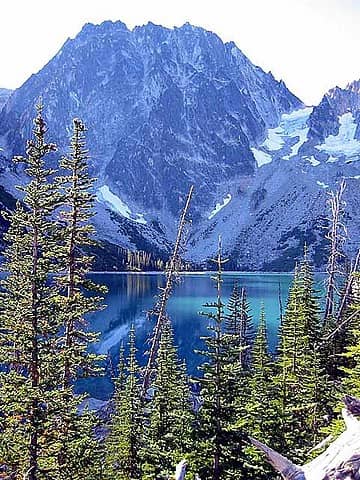 The obligatory short of Dragontail looming above Colchuck Lake. Perfect weather for a perfect day. 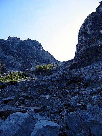 A view of Aasgard Pass from the bottom. It's daunting, but doable. 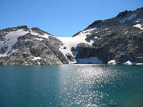 Lake Brynhild/Isolation Lake under the watchful gaze of East Dragontail. 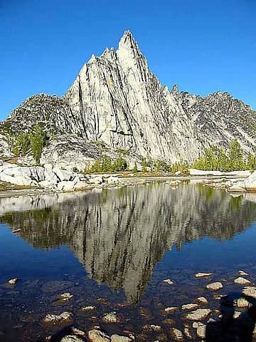 The obligatory shot of Prussik Peak's reflection in Gnome Tarn. Mmmm. Tasty. 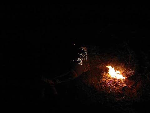 Chris getting a little shuteye while I fed the fire. We weren't *that* far above 5000 feet. 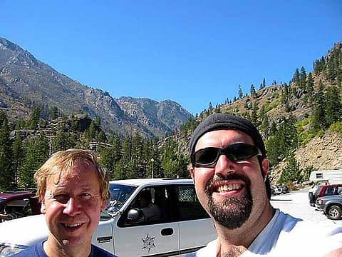 Chris and I, and our welcome party from the Chelan County Sheriff's Department.
"There is only one basic human right, the right to do as you damn well please. And with it comes the only basic human duty, the duty to take the consequences." -P.J. O'Rourke
"Ignorance is natural. Stupidity takes commitment." -Solomon Short
"There is only one basic human right, the right to do as you damn well please. And with it comes the only basic human duty, the duty to take the consequences." -P.J. O'Rourke
"Ignorance is natural. Stupidity takes commitment." -Solomon Short
|
| Back to top |
  
|
|
Dayhike Mike
Bad MFKer
Joined: 02 Mar 2003
Posts: 10958 | TRs | Pics
Location: Going to Tukwila |
Out of curiosity, has anyone else come down this route recently? Did we miss something in the dark that kept us from finding the more reasonable route that I remembered from years past? I'm thinking I might not have kept far enough right early on and been a ridge too far to the left.
Scenery-wise, I highly recommend the Shield/Earle/Mesa route -- it's a nice variation on the typical (though I do miss that drop from Viviane to Snow Lake). Shield and Earle are pretty, though they can get a bit buggy in the early season, and Mesa's quite striking with the stone wall flanking it's southeast side.
Any comments on other routes in/out?
I'm wanting to try the Cannon Mountain approach, up and over the Druid Plateau. I've heard the Rat Creek route is rough and brushy. The Temple Canyon route is an interesting variant, though the navigation of the cliffs above Nada can get a little tricky. Anyone dropped in to the Snow Lakes from Wedge Mountain and willing to comment on just how technical that descent is?
Thanks in advance!
"There is only one basic human right, the right to do as you damn well please. And with it comes the only basic human duty, the duty to take the consequences." -P.J. O'Rourke
"Ignorance is natural. Stupidity takes commitment." -Solomon Short
"There is only one basic human right, the right to do as you damn well please. And with it comes the only basic human duty, the duty to take the consequences." -P.J. O'Rourke
"Ignorance is natural. Stupidity takes commitment." -Solomon Short
|
| Back to top |
|
|
Backpacker Joe
Blind Hiker

Joined: 16 Dec 2001
Posts: 23956 | TRs | Pics
Location: Cle Elum |
MB, I'd go with you in/on that route anyday! Ive been in there, yet not gone in or out that way!
TB
"If destruction be our lot we must ourselves be its author and finisher. As a nation of freemen we must live through all time or die by suicide."
Abraham Lincoln
"If destruction be our lot we must ourselves be its author and finisher. As a nation of freemen we must live through all time or die by suicide."
Abraham Lincoln
|
| Back to top |
|
|
Dean
(aka CascadeHiker)

Joined: 02 Mar 2002
Posts: 1967 | TRs | Pics
Location: ex Kennewick, Wa & Lehi Utah |
|
Dean
(aka CascadeHiker)
|
 Mon Mar 03, 2003 8:07 am |
|
|
Great trip report and your pics are very enjoyable. I might be able to shed some light on the water level aspect that you encountered on your trip. There is a reason for what you saw.
The water in Colchuck was lowered to feed the Leavenworth fish hatchery system. I was camped at Colchuck on Aug 28th and the water level was normal. When my son in law and I returned from 3 days in the Enchantments, we found the water level down about 3 feet. Then when Tom and I were there three weeks later, the water level was down at least 6 feet. Almost all of the lakes in the region are used by the Leavenworth fish hatchery and if you've ever seen Snow Lake (the upper one) down by 20 or more feet, you get irritated by what you see. Nada Lake, Snow Lakes, Stuart Lake, 8 Mile Lake, Colchuck Lake, Klonaqua Lakes, etc are all part of the system and in drought years you'll find these lakes artificially lowered in late summer. This system was put in place sometime around 1918, I can't give you the exact year(s) but it was done before the public (us) knew what treasures were hidden in the mountains above Leavenworth. Perhaps you've seen the "vertical" waterfall that pours out from the hillside above Nada Lake (all part of the system)
I've been out via Cannon mountain (camped at Coney the night before) and in via Crystal Creek. I've also been out Toketie twice, once by the Becky route (the route you took) and by going straight down the creek bed. Both routes leave a lot to be desired and should never be done solo. You could break a leg very easily in the mess that was left by the fire of '94. Rat creek is a real grunt as is going up Hook creek. Ibex posted a story about going in Rat creek and you might want to check with him regarding Rat, and he has also been in via Cannon Mtn. Consider Crystal as the best of the lot and Cannon next. I have never met anyone who has done the Wedge mountain variant I know Allison is a big fan of the Temple canyon route and has commented on this route in other threads here. I have a Yahoo group called the Enchantment Lakes of Washington and you might want to join with myself and other Enchantment fans there.
Again, thanks for posting your report. 
|
| Back to top |
|
|
kleet
meat tornado

Joined: 06 Feb 2002
Posts: 5303 | TRs | Pics
Location: O no they dih ent |
|
kleet
meat tornado
|
Mon Mar 03, 2003 9:19 am |
|
|
I've done the Wedge Mountain route twice now. If you take your time, it's not too bad. The haul up the east side of Wedge through the old burn is hot, dry and steep but is only a couple miles long. An early morning start is a must. Routefinding once you top Wedge is a real pain, as is finding a decent place to cross Snow Creek. I could show someone the route but could never hope to describe how to do it. It's definitely an adventure!
A fuxk, why do I not give one?
A fuxk, why do I not give one?
|
| Back to top |
|
|
Larry
Member

Joined: 22 Feb 2003
Posts: 1084 | TRs | Pics
Location: Kitsap |
|
Larry
Member
|
Mon Mar 03, 2003 4:17 pm |
|
|
GREAT trip report. Felt like I was there. Fine images too! This is good stuff, and I appreciate it. Makes my "breaks" at work that much better...
|
| Back to top |
|
|
Dayhike Mike
Bad MFKer

Joined: 02 Mar 2003
Posts: 10958 | TRs | Pics
Location: Going to Tukwila |
Glad you all enjoyed the story...it's fun to recount old trips for me as well.
Backpacker Joe: I'll be glad to take you up on the offer.  CascadeHiker: That does shed quite a bit of light of the subject and explain why it was just sooo low. I've seen Snow Lakes lowered before, but this was the first time I'd seen Colchuck thus affected.
Cannon Mountain is looking like something I want to do at least once this year. If my dad's not up for it yet, I might drag the same guy along and take him in Cannon and out the standard route through the Snow Lakes...give him the complete tour of the town.
How is the scramble up/down from Coney onto the top of Cannon? The Topo makes it look interesting, but I can never be 100% certain just from looking at maps just how passable the terrain is. And Beckey shows two variants on the approach -- one which goes straight to the top along the ridgeline, and another that keeps lower and comes into The Lost World Plateau via Rat Creek around Mesa Lake.
Kleet: Thanks for the advice! I'm wanting to check out Wedge on the early side this year and will be keeping an eye out for good routes.
Thanks again to all!
Michael
CascadeHiker: That does shed quite a bit of light of the subject and explain why it was just sooo low. I've seen Snow Lakes lowered before, but this was the first time I'd seen Colchuck thus affected.
Cannon Mountain is looking like something I want to do at least once this year. If my dad's not up for it yet, I might drag the same guy along and take him in Cannon and out the standard route through the Snow Lakes...give him the complete tour of the town.
How is the scramble up/down from Coney onto the top of Cannon? The Topo makes it look interesting, but I can never be 100% certain just from looking at maps just how passable the terrain is. And Beckey shows two variants on the approach -- one which goes straight to the top along the ridgeline, and another that keeps lower and comes into The Lost World Plateau via Rat Creek around Mesa Lake.
Kleet: Thanks for the advice! I'm wanting to check out Wedge on the early side this year and will be keeping an eye out for good routes.
Thanks again to all!
Michael
"There is only one basic human right, the right to do as you damn well please. And with it comes the only basic human duty, the duty to take the consequences." -P.J. O'Rourke
"Ignorance is natural. Stupidity takes commitment." -Solomon Short
"There is only one basic human right, the right to do as you damn well please. And with it comes the only basic human duty, the duty to take the consequences." -P.J. O'Rourke
"Ignorance is natural. Stupidity takes commitment." -Solomon Short
|
| Back to top |
|
|
Randy
Cube Rat

Joined: 18 Dec 2001
Posts: 2910 | TRs | Pics
Location: Near the Siamangs |
|
Randy
Cube Rat
|
Tue Mar 04, 2003 12:38 pm |
|
|
We were up on the Druid Plateau in mid August last year and had a chance to look down on Coney in a couple of places. Saw a couple chutes that may have gone all the way down to the lake, but they had hard snow in the upper half and were probably 50-60º. Plenty of cliffs in there too. There may have been another spot where the ascent or descent would be easier, but we weren't going that way anyhow. That said, it's a simple enough route coming directly up the hill from Shield.
|
| Back to top |
|
|
Backpacker Joe
Blind Hiker
Joined: 16 Dec 2001
Posts: 23956 | TRs | Pics
Location: Cle Elum |
Havent been into Coney yet. Going to have to do it this year!
Thanks.
TB
"If destruction be our lot we must ourselves be its author and finisher. As a nation of freemen we must live through all time or die by suicide."
Abraham Lincoln
"If destruction be our lot we must ourselves be its author and finisher. As a nation of freemen we must live through all time or die by suicide."
Abraham Lincoln
|
| Back to top |
|
|
Stefan
Member

Joined: 17 Dec 2001
Posts: 5091 | TRs | Pics
|
|
Stefan
Member
|
Tue Mar 04, 2003 6:17 pm |
|
|
| MichaelB wrote: | | Any comments on other routes in/out? |
Yes there is a better way. I have heard the Toketie drainage sucks. There is a climbers path in the drainage to the south which is much better--I have been up it, but not down it. It comes out in boulders about 1/2 way up Nada Lake.
Path is somewhat obvious above Earle Lake at the pass heading down and east.
To access the path go 1/2 way up Nada, cross a stream, then go west through a boulder field and up aiming to climbers left. The boulders turn into small shrubs and dirt and you are aiming for the apex of the coulouired V you are heading up, but don't go all the way. To the right through some small vine maple trees is the path leading up over slabs--it is kind of hidden. Sometimes the path is there, sometimes it isn't. The path becomes more apparent around 6000feet. If you are doing class 4 moves at the couloired V, then you are not on the right path. Class 3 max for some small areas. Not much brush to contend with either.
|
| Back to top |
|
|
Mike Collins
Member

Joined: 18 Dec 2001
Posts: 3096 | TRs | Pics
|
|
Mike Collins
Member
|
Tue Mar 04, 2003 7:12 pm Trail up from Nada Lake
|
|
|
Thanks to Stefan I have been both up and down the Nada Lake approach which he references. On the west side of Nada Lake, about 400 feet past a double-log bridge you will see a sign for a toilet. Walk on the path toward the toilet but continue on a bootscarred path. Much of the way is marked with cairns and it would be difficult to follow if snow covered the ground. But it gets you to the high country without brush.
|
| Back to top |
|
|
Dean
(aka CascadeHiker)
Joined: 02 Mar 2002
Posts: 1967 | TRs | Pics
Location: ex Kennewick, Wa & Lehi Utah |
|
Dean
(aka CascadeHiker)
|
Tue Mar 04, 2003 7:47 pm |
|
|
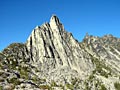
Here is a pic of Coney Lake taken from near Cannon mtn. It looks like a heart from above and I camped on the little peninsula that juts out. I climbed up and out by a gully that ascended west as at this time of the year there wasn't any snow to deal with and it was just a scramble.
|
| Back to top |
|
|
Backpacker Joe
Blind Hiker
Joined: 16 Dec 2001
Posts: 23956 | TRs | Pics
Location: Cle Elum |
Maybe I'll take that route this year. Once up the ridge where do you end up?
TB
"If destruction be our lot we must ourselves be its author and finisher. As a nation of freemen we must live through all time or die by suicide."
Abraham Lincoln
"If destruction be our lot we must ourselves be its author and finisher. As a nation of freemen we must live through all time or die by suicide."
Abraham Lincoln
|
| Back to top |
|
|
Dayhike Mike
Bad MFKer
Joined: 02 Mar 2003
Posts: 10958 | TRs | Pics
Location: Going to Tukwila |
Stefan - That's the Temple Canyon route. I've been out that way, but never up it (probably because I swear by Colchuck and Aasgard for the ascent -- Cannon may change my mind. Note to self: fun day hike possibility might be Stuart Lake Trailhead to Colchuck Lake to Aasgard Pass to Cannon Mountain/Coney Lake and down the Cannon Mountain approach to car. Mmm.).
There are two entrances to Temple Canyon. The first one's the one that leaves Earle lake from the northeast end and is the one most people trip across --- I and my dad took it for the first time (accidentally) 10-12 years ago while trying to take Toketie out with no maps in hand.
The other route is a more direct traverse from near Prusik Pass. You end up at the head of the canyon, with great views of Temple and the whole Lost World Plateau.
"There is only one basic human right, the right to do as you damn well please. And with it comes the only basic human duty, the duty to take the consequences." -P.J. O'Rourke
"Ignorance is natural. Stupidity takes commitment." -Solomon Short
"There is only one basic human right, the right to do as you damn well please. And with it comes the only basic human duty, the duty to take the consequences." -P.J. O'Rourke
"Ignorance is natural. Stupidity takes commitment." -Solomon Short
|
| Back to top |
|
|
Dayhike Mike
Bad MFKer
Joined: 02 Mar 2003
Posts: 10958 | TRs | Pics
Location: Going to Tukwila |
Dean,
Thanks for the pic of Coney...lonely and isolated that one. I'll have to see it myself this year...
"There is only one basic human right, the right to do as you damn well please. And with it comes the only basic human duty, the duty to take the consequences." -P.J. O'Rourke
"Ignorance is natural. Stupidity takes commitment." -Solomon Short
"There is only one basic human right, the right to do as you damn well please. And with it comes the only basic human duty, the duty to take the consequences." -P.J. O'Rourke
"Ignorance is natural. Stupidity takes commitment." -Solomon Short
|
| Back to top |
|
|
|
|
You cannot post new topics in this forum
You cannot reply to topics in this forum
You cannot edit your posts in this forum
You cannot delete your posts in this forum
You cannot vote in polls in this forum
|
Disclosure: As an Amazon Associate NWHikers.net earns from qualifying purchases when you use our link(s). |


