| Previous :: Next Topic |
| Author |
Message |
motsies
Member

Joined: 06 Jul 2006
Posts: 25 | TRs | Pics
|
|
motsies
Member
|
 Fri Oct 20, 2006 10:06 am |
|
|
Plan:
Solo backpack trip in Yosemite from Wawona to Yosemite Valley via Red Peak Pass and the Merced River; approximately 57 miles. This would be the longest hike I've ever done, solo or otherwise. Relatively easy to plan out using the YNP Trail Illustrated map and by combining several hikes via guide books from the Seattle Public Library.
Fri, 10/6: Leave Seattle
All packed up and leave work at 12:30 pm (on the road at last!!!!!!!!) to get by Portland before the Friday rush and at least to the California border before stopping. I love taking road trips like this as you just crank the tunes, step on the gas and envision the adventure to come. I drove until about 10 pm and camp at a forest service site on the western slopes of Mt. Shasta.
Sat, 10/7: Arrive in Yosemite / Begin backpack
Up early and on the road around 6:30 am getting a nice view of Shasta and the surrounding forest in the morning light. Cruise down I5 and Rt. 99 to Medera, CA for access directly to the Wawona entrance. Through the gate at 1:30 pm with a simple plan: talk to rangers, get permits, camp at Wawona and pack up for an early start the next morning. But in Yosemite, "fall" means "october 1st", so no rangers to speak to in Wawona for reassurance/background on my route. Funny how you sometimes feel a need for ranger contact to discuss your trip or maybe help validate what you're going to do. Anyway, I quickly self-registered, picked up my bear container from the Wawona Store and headed to the campground, where I hit snag #2.
After 10/1, the Wawona campground is first come first serve, so being Columbus Day weekend it was full. I didn't like the idea of leaving the park for the night, so being only 2:45 pm at this point, I decided to start my trip a little early. Drove to the Chilnualna Falls trailhead, packed up, sorted all my food and I was on the trail by 3:30 pm. After all the planning, it was almost a relief to leave in this way w/o an evening to pack/repack and worry about whether I had everything I needed.
So the hike begins!!! The water levels are low (as expected of course) and you quickly ascend along the Chilnualna Creek before joining a more gentle trail in 0.5 miles. As far as creeks go, water will be low or nonexistent during the whole trip and I can only imagine what they're like in the spring (future trip!!!) b/c they're stunning w/ just all the smooth rocks. Get up the 4.2 miles to the falls in about 2.5 hrs. w/ slight rain falling and great views for the last 0.5 mile traverse. Continue up above the falls and setup camp for the night. Still very anxious for the trip to come as I go to sleep, though sleep came easy in the cold night. Plus I was catching the end of the harvest moon, so headlamp was not really needed during the night.
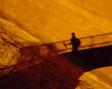
Stairway to heaven
Upper Chilnualna Falls
Sun, 10/8: Chilnualna Falls to Royal Arch Lake
Up and on the trail by 8:30 am. Some choices now that I'm basically 1/2 day ahead of schedule, so I decided to head slightly off my route to Royal Arch Lake for the night. I had previously seen a photo of the lake and I didn't want to pass it by, and now I could actually camp there for a night. My pace seemed very quick in the cool morning air and I stopped for lunch at the calming Crescent Lake. Continued on to Johnson Lake, whose rocky shoreline gave me that "i'm really at Yosemite" feeling. Arrived at Royal Arch Lake (8.6 miles) at 2:15 pm, ending hiking for the day and leading to some doubt about whether I should have continued more to stay more "ahead", but part of this trip is relaxing too and this was a great spot to do it. Spent the afternoon relaxing by the lake, reading a little and making slight changes to the mileage and options for the days to come.
Fall color near Crescent Lake
Crescent Lake
Johnson Lake
Royal Arch Lake
Mon, 10/9: Royal Arch Lake to Lower Ottoway Lake
Up early again and hiking around 8:00 am as this would figure to be my hardest day: 12.4 miles w/ approx. 3,200 in total gain to Lowe Ottoway Lake @ 10,000'; and about 1/2 way up Red Peak Pass (the trip's highpoint @ 11,200'). But the thing I've discovered is that backpacking in Washington prepares you well for most other places b/c the trail would rise 1,300' over final 3 miles to Lower Ottoway Lake; hardly the 800'-1000' per mile of many trails in the western Cascades. I hiked the 8.3 miles hard from Royal Arch to Merced Pass and arrived just past noon to no views on the treed pass.
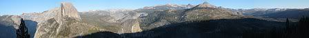
This might have been the low point of the trip as I had expected to enjoy the views and lunch at the pass. Hiking solo, it is easy to have moments such as these as little details don't go as initially perceived. I began to feel as if I was too much about the hike, mileage, etc. instead of enjoying what I was actually doing and where I was. But another great thing about hiking is that things can change fast. About 1/4 mile down from the pass it opened up to my first views of a few of the peaks surrounding the the far off valley floor (Mount Starr King being the most prominent). Also, the landscape changed from mostly forested to that mix of open granite and scattered trees.
As I continued up to Lower Ottoway @ 2:45 pm, the weather was in transition and rain appeared imminent w/ heavy clouds up towards Red Peak. After a quick setup, it never came and I enjoyed the lake w/ many granite coves and small islands. Small amounts of snow from the previous week had remained on many areas of the trail to this point and on the few peaks visible above. Basically at this point I've completed 1/2 of my hike w/ only 1,300' gain remaining up Red Peak Pass and 26+ miles of mostly downhill to the valley. Felling pretty good physically w/ some general soreness in the hips and right knee, and slightly concerned about all the pounding on my feet. Good thing I've got tevas for around camp!!! By night fall, the clouds seemed to settle around 11,000'.
First views towards the valley
Lower Ottoway Lake
Tues, 10/10: Lower Ottoway down along Illilouette Creek
Weather-wise, this day would amount to one of the stranger days I've experienced while hiking. I awoke to snow pelting the rain fly around 5 am that would continue slow, but steady until about 9:30 am. Despite the cold, snow is easier than rain to deal w/ in both a practical and psychological sense. But up above, the clouds were very dark and the whole area around Red Peak was socked in. I enjoyed some hot drinks and waited past my expected start time as I debated my next move in my head. Clouds to the west continued to roll in and thunder roared a few times as short downpours of snow pellets came down. Crossing Red Peak Pass, which I couldn't see, would amount to 6 miles (3 up, 3 down) of exposure. Thus came the hardest decision of the trip: to head down. Being solo, this wasn't really a hard decision but more of an agonising one.
All packed and bundled up, I headed down along Illilouette Creek as thunder continued and weather would quickly switch from windy and snowy, to clear and warm, to sunny and rainy; layers on, layers off, layers on, etc. The nice thing about route changes is that whatever you get to do, you wouldn't have done otherwise and every experience is unique. Illilouette Creek has many beautiful sections of open granite w/ views and down further you go through a section of forest recovering from a 2001 blaze. I crossed the creek many times and often side streams were dry, so I continued a little south towards Mono Meadows for guaranteed water. All in all it was 12.2 miles, but mostly downhill.
So now what to do?? The previous night I was anxious b/c I still had 1/2 the hike remaining and tonight I'm camped just 8 miles from the valley floor w/ a feeling that the trip is just about over. I contemplated returning to Wawona via Buena Vista Pass, but didn't want to pass on the joy of entering the valley after several days in the backcountry. As I ended the day, the best option looked to be to head to Little Yosemite w/ and afternoon hike up Half Dome.
Cold morning
Heading down the Illilouette
2001 blaze area
Nice cloud moving overhead
Wed, 10/11: Illilouette Creek to Little Yosemite Valley
During the night I had my only bear encounter of the trip: nothing was in my pack, but a bear was curious and after a few returns and splashing in the nearby creek, I was able to scare him/her off but not before my raincover was torn in a few spots. After a restless sleep, I awoke to a glorious morning w/o a cloud in the sky!! With rain the previous evening and a cold night, but rainfly was frozen and the ground frosted. I moved up to a clearing to warm up in the sun and had great views of Starr King and Red Peak (now clear of course!! haha).
Only 5.5 miles to Little Yosemite w/ constantly improving views and a stop at Nevada Falls, where I encountered, gasp, day hikers!!!! Nevada Falls was very low of course, but the morning sun was stunning on Grizzly Peak and the surrounding rock faces. Made my way to Little Yosemite around noon for lunch and camp setup; obviously mixed feelings as I was now out of the "real" backcountry. I started up Half Dome, making the 3.5 mile trek in about 2 hours. Hiking w/o a full pack was like "wearing nothing at all, nothing at all" (in my best Ned Flanders' voice). No clouds in sight and views all around; nothing is quite like Yosemite. Walked all over the summit and just enjoyed the moment. Getting to go up Half Dome was another memorable bonus of the route change as it was not on the original itinerary. Later afternoon sun as I returned to camp and enjoyed talking to fellow hikers. The bathrooms were a welcome change after days of digging holes, but I cannot imagine this campground when full in the summer months. As the last night of the hike, I enjoyed the evening and stars shinning above the backside of Half Dome.
Early morning
Nevade Falls area
Getting on the John Muir Trail
Half Dome
Thurs, 10/12: Hike to the Valley and back to Wawona
Rise in the dark and pack up to enjoy the sunrise against the backside of Half Dome. As w/ the whole trip, being up early is so refreshing as night gives way to day and this tend to be the moments I remember most. As I near Nevada Falls, a few day hikers emerge from the Vernal Falls trail and inquire if I've been "up and down" already. LOL!!! This would be a common question in the hour or so to come. Down to Vernal Falls and along the Mist Trail (w/ no mist) to Happy Isles. Hiked along the campground to the shuttle stop as the generators were pumping. Good to be back to civilization?
This day would involve some logistical issues to get back to my car. I rode the shuttle to Yosemite Lodge to get a ticket for the bus to Glacier Point. I had some time to kill before the 1:30 departure, so I checked out the Ansel Adams gallery and actually enjoyed the valley w/ the minimal mid-week crowds. I had to pay the full one-way fare of $20 even though I had them drop me off at the Chinquapin intersection. From there, I would have the hitchhike the 14 miles to Wawona. A tough road to hitchhike w/ all the quick turns, but after about 30 mins. and 1.5 miles walked a kind soul helped me out. Hiked 2 miles from the Wawona Store to my car and the circle was complete!!! Final talley was close to 60 miles, including the 7 miles day-hiked up and down Half Dome. Being only 3:45 pm, I cleaned up, set up at ten at the Wawona campground and was off to Glacier Point to enjoy the views and sunset. And how impressive it was after all the effort of the past 6 days.
Half Dome at night - too much moon
What - no hole??
Back of Half Dome in the AM
Vernal Falls / Mist Trail
Hike complete!!
Glacier Point
 Fri, 10/13: Sunrise at Washburn Point; Leave park
Left the campground at 4 am to enjoy the morning transition from Washburn Point. Over the next 2.5 hours, no one else arrived as I took in the stars, shadows, coyote yelps and slow sunrise. Like many spots in Yosemite, it's a vantage point of pure magnificence and quite overwhelming. With the sun now up, it was down to the valley w/ stops at some of the classic spots including Tunnel View, Stoneman Bridge, Swinging Bridge. By 9:30 am I was headed out via Tioga Road as I was headed to a friend's place in Carson City. Eastward from Porcupine Flat is just gorgeous as you pass Tenaya Lake and Tuolumne Meadows. I'm sure my next trip back will be up in this area. Out the gate and down to Mono Lake.
Washburn Point
Valley
And so ended my Yosemite trip and the longest hike I've completed. I still had a few days remaining catching up w/ friends from Carson City, Reno and Sacramento. And also a lovely hike near the Blue Lakes (south of Lake Tahoe) where there was a beautiful patch of Aspens on the road up to Carson Pass.
I know it's not a PNW report but I figured people here would enjoy the photos and details of my adventure. Our reasons may not all be the same, but the hiking and love of nature is what connects us.
Enjoy, Ben
Full Photo Album: http://www.kodakgallery.com/I.jsp?c=mthtq0f.c5hl3xp7&x=0&y=ku5da7
Fri, 10/13: Sunrise at Washburn Point; Leave park
Left the campground at 4 am to enjoy the morning transition from Washburn Point. Over the next 2.5 hours, no one else arrived as I took in the stars, shadows, coyote yelps and slow sunrise. Like many spots in Yosemite, it's a vantage point of pure magnificence and quite overwhelming. With the sun now up, it was down to the valley w/ stops at some of the classic spots including Tunnel View, Stoneman Bridge, Swinging Bridge. By 9:30 am I was headed out via Tioga Road as I was headed to a friend's place in Carson City. Eastward from Porcupine Flat is just gorgeous as you pass Tenaya Lake and Tuolumne Meadows. I'm sure my next trip back will be up in this area. Out the gate and down to Mono Lake.
Washburn Point
Valley
And so ended my Yosemite trip and the longest hike I've completed. I still had a few days remaining catching up w/ friends from Carson City, Reno and Sacramento. And also a lovely hike near the Blue Lakes (south of Lake Tahoe) where there was a beautiful patch of Aspens on the road up to Carson Pass.
I know it's not a PNW report but I figured people here would enjoy the photos and details of my adventure. Our reasons may not all be the same, but the hiking and love of nature is what connects us.
Enjoy, Ben
Full Photo Album: http://www.kodakgallery.com/I.jsp?c=mthtq0f.c5hl3xp7&x=0&y=ku5da7
Find your place on the planet. Dig in, and take responsibility from there - Gary Snyder
Find your place on the planet. Dig in, and take responsibility from there - Gary Snyder
|
| Back to top |
  
|
|
gorp
Member

Joined: 25 Jun 2003
Posts: 226 | TRs | Pics
Location: Seattle |
|
gorp
Member
|
Fri Oct 20, 2006 10:12 am |
|
|
|
| Back to top |
|
|
ActionBetty
Im a dirty hippie!

Joined: 06 Jul 2003
Posts: 4807 | TRs | Pics
Location: kennewick, wa |
|
ActionBetty
Im a dirty hippie!
|
Fri Oct 20, 2006 10:13 am |
|
|
Beautiful pics and great TR!  I have to ask about the glove picture..whats up with that? I have to ask about the glove picture..whats up with that?
"If you're not living good, you gotta travel wide"...Bob Marley
"If you're not living good, you gotta travel wide"...Bob Marley
|
| Back to top |
|
|
motsies
Member
Joined: 06 Jul 2006
Posts: 25 | TRs | Pics
|
|
motsies
Member
|
Fri Oct 20, 2006 10:27 am |
|
|
gloves are for the cable walkway up half dame...you really need them for the way down!!
Find your place on the planet. Dig in, and take responsibility from there - Gary Snyder
Find your place on the planet. Dig in, and take responsibility from there - Gary Snyder
|
| Back to top |
|
|
Tazz
Member

Joined: 27 Apr 2005
Posts: 7902 | TRs | Pics
|
|
Tazz
Member
|
Fri Oct 20, 2006 10:43 am |
|
|
very nice thanks for sharing
|
| Back to top |
|
|
RG
Member
Joined: 04 Feb 2005
Posts: 27 | TRs | Pics
Location: Sammamish, Wa |
|
RG
Member
|
Sat Oct 21, 2006 8:30 am |
|
|
Nice Pictures!! Brings back memories of last spring when we did Half Dome. I thought the same thing about Little Yosemite Valley CG, being over crowded and hordes of people, but was pleasantly surprised after spending 2 nights there and enjoying great company at the comunal fire pit. Btw, have you read "Shattered Air"? Excellent read about a rescue on Half Dome. It is in the King County library system. Thanks for sharing! Rick
|
| Back to top |
|
|
ree
Member

Joined: 29 Jun 2004
Posts: 4399 | TRs | Pics
|
|
ree
Member
|
Sat Oct 21, 2006 9:25 am |
|
|
Lovely pictures, and great trip report!
Yah, thanks for asking about the glove picture, AB. I was wondering too!
Sierras really are quite magical.
Was the valley quite crowded?
|
| Back to top |
|
|
|
|
You cannot post new topics in this forum
You cannot reply to topics in this forum
You cannot edit your posts in this forum
You cannot delete your posts in this forum
You cannot vote in polls in this forum
|
Disclosure: As an Amazon Associate NWHikers.net earns from qualifying purchases when you use our link(s). |


