| Previous :: Next Topic |
| Author |
Message |
whitebark
Member


Joined: 08 Jul 2005
Posts: 1864 | TRs | Pics
Location: Seattle |
A fine new hike along the I-90 corridor, recently opened. Actually reopened, as the North Ridge was the original route used to get to Mount Washington. To get to the North Ridge, follow the standard trail past the Owl Hike Vista to the major junction at 2900'. Here, follow any signage and instructions you see, going right at the junction instead of left (the standard route up). Volunteers have done incredible work brushing out the road/trail that leads up into the upper basin of Washington Creek. The actual North Ridge trail is steep and involves a few tricky steps up rock ledges. Otherwise, it's a fun scramble. The views should be great from here, but I climbed the route in clouds and didn't get to see anything. At 4000 feet the scramble ends at the side of an old logging road, which you follow until you rejoin the Standard"Great Wall" route at a junction with another larger road. The final 200' climb to the summit proceeds as usual.
Another nice thing about Mt Washington is that it gets much less use than Mt Si or Mailbox Peak. Snowshoeing is supposed to be good here, too, at higher elevations (I haven't tried it but talked to people who have).
The climb to Mt Washington via the N Ridge is fun, highly recommended--a great new addition to the stock of close-to-seattle hikes.
|
| Back to top |
  
|
|
Sabahsboy
Member

Joined: 18 Jul 2006
Posts: 2484 | TRs | Pics
Location: SW Sno County |
|
Sabahsboy
Member
|
 Wed Oct 18, 2006 7:07 pm Mt. WA North Ridge, new "trail" route
|
|
|
Thank you, Whitebark. I must try this!
When residing at Mercer Island, it was such a quick trip to State Park parking lot (up stream of Twin Falls). Explored some of the lower route and hoped to do more in the future. Well, the future is here! Now!
Can two biggish dogs make the trip up and over the "rough spots"? I keep my two on 4 foot leads. We had some trouble on the slab going up to Glacier Basin in 2005...had to help pups down so they would not get injured. One pup broke a nail; it bled and required a visit to the vet.
Saturday, we made our 2nd visit of 2006 to Rattlesnake Ridge, TH just off I-90. The fog parted just as we reached a high point on one of the logging roads and a view that was great, excepting the reason the view was there at all, power transmission line clearcuts. Quite a few glorious vine maples colonizing the "transmission" corridor.
Of disappointment and note: a road has been cut, running off the regularly used road. That old gravel road bed serves power lines and the water tank and continues upward to recent and old clearcuts. The new road starts across from the east gate to the water tank and contours, heading east. It may head toward North Bend and a housing development. It is too soon to walk it...well, I suppose one could. It has been graded but appears not yet ready for any drivers.
What a shame...it was near here I have seen bear not far from the Snoqualmie City Park...which is undergoing "improvements".
Happy Trails!
|
| Back to top |
|
|
Coasty
I like Salmon!
Joined: 02 Apr 2006
Posts: 762 | TRs | Pics
Location: Kodiak, AK |
|
Coasty
I like Salmon!
|
Wed Oct 18, 2006 9:08 pm Mt Washington
|
|
|
Thanks for the info. Are there any maps or guidebooks to describe the trails on Mt Washington?
Thanks,
Jason
|
| Back to top |
|
|
whitebark
Member

Joined: 08 Jul 2005
Posts: 1864 | TRs | Pics
Location: Seattle |
| Sabahsboy wrote: | | Can two biggish dogs make the trip up and over the "rough spots"? I keep my two on 4 foot leads. We had some trouble on the slab going up to Glacier Basin in 2005...had to help pups down so they would not get injured. One pup broke a nail; it bled and required a visit to the vet.
Happy Trails! |
I think that dogs could do the N ridge (which is 2 miles shorter than the standard route, by the way)
|
| Back to top |
|
|
whitebark
Member
Joined: 08 Jul 2005
Posts: 1864 | TRs | Pics
Location: Seattle |
| c4jc88 wrote: | | Thanks for the info. Are there any maps or guidebooks to describe the trails on Mt Washington?
Thanks,
Jason |
The Green Trails map (Snoqualmie Pass gateway peaks #206s) covering this area shows the Mt Washington hike , except for the N ridge path, which is too new. This map is well worth getting. The "Winter Walks and Hikes" guidebook (Mountaineers) I think also has info on Mt Washington.
|
| Back to top |
|
|
rodman
Member
Joined: 03 May 2005
Posts: 49 | TRs | Pics
|
|
rodman
Member
|
Thu Oct 19, 2006 2:26 pm |
|
|
Thank for the information about a "new" route up Mt Washington. Using the information provided I have guessed at the track of the new route shown here:
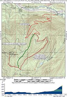 NEW-MOUNT-WASHINGTON-TRAIL
|
| Back to top |
|
|
Mesahchie Mark
A Lerxst

Joined: 10 May 2005
Posts: 700 | TRs | Pics
Location: In Wonderland |
Hmmm - nice, but I think it's still shorter to bushwhack straight-aways to the north ridge, then follow the bootpath up from there. New path might make a nice descent route, though.
|
| Back to top |
|
|
Malachai Constant
Member

Joined: 13 Jan 2002
Posts: 16092 | TRs | Pics
Location: Back Again Like A Bad Penny |
Went up to check this out today. The map Rodman posted is incorrect. The path pretty much follows the scramble route mentioned by Mark. After passing Owl Point you continue strait and cross the creek and follow old roads under the pinnacles and recross the creek up to a shallow pond then another old road intersects the ridge. These roads used to be choked with brush and were effectively impassable. One on the ridge you follow the old scramble path which has seen some clearing but still contained mossy boulders and steep dirt. Soon you intersect the spur high on the ridge which can be followed to the main road then up the path on the South ridge. This trail eliminates a steep dirt devilclub section. I will post a map later.
"You do not laugh when you look at the mountains, or when you look at the sea." Lafcadio Hearn
"You do not laugh when you look at the mountains, or when you look at the sea." Lafcadio Hearn
|
| Back to top |
|
|
whitebark
Member
Joined: 08 Jul 2005
Posts: 1864 | TRs | Pics
Location: Seattle |
| rodman wrote: | Thank for the information about a "new" route up Mt Washington. Using the information provided I have guessed at the track of the new route shown here:
yep, this map is not correct on the location of the N Ridge route.
NEW-MOUNT-WASHINGTON-TRAIL |
|
| Back to top |
|
|
Malachai Constant
Member
Joined: 13 Jan 2002
Posts: 16092 | TRs | Pics
Location: Back Again Like A Bad Penny |
Here is the corrected map with abandoned roads in Red Old Trail Green and New Trail in Yellow. Incidently there are maps at the junction.
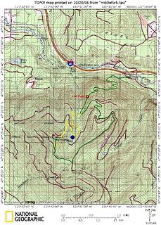 New Mount Wasington Trail
"You do not laugh when you look at the mountains, or when you look at the sea." Lafcadio Hearn
"You do not laugh when you look at the mountains, or when you look at the sea." Lafcadio Hearn
|
| Back to top |
|
|
|
|


