| Previous :: Next Topic |
| Author |
Message |
Snowbrushy
Member


Joined: 23 Jul 2003
Posts: 6670 | TRs | Pics
Location: South Sound |
| Veneer wrote: | | We have a celebrity posting on this board: |
Yes, she always gets the good press stuff. 
Oh Pilot of the storm who leaves no trace Like thoughts inside a dream Heed the path that led me to that place Yellow desert stream.
Oh Pilot of the storm who leaves no trace Like thoughts inside a dream Heed the path that led me to that place Yellow desert stream.
|
| Back to top |
  
|
|
Scrooge
Famous Grouse

Joined: 16 Dec 2001
Posts: 6966 | TRs | Pics
Location: wishful thinking |
|
Scrooge
Famous Grouse
|
 Sat May 19, 2007 2:44 pm |
|
|
Something lost behind the ranges. Lost and waiting for you....... Go and find it. Go!
|
| Back to top |
|
|
peppersteak'n'ale
Member
Joined: 28 Aug 2003
Posts: 1996 | TRs | Pics
|
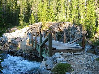
Here's the MC Road in case anyone wants to know what the twin bridges crossing looks like. These pics are a few weeks old, but I'm just getting to posting them now (better late than never, I suppose):
The old way across
The new way across
|
| Back to top |
|
|
greg
Member
Joined: 23 Jun 2003
Posts: 1159 | TRs | Pics
|
|
greg
Member
|
Thu Jun 28, 2007 1:03 pm |
|
|
Just heard from a Forest Service guy that the Waptus River Bridge, a huge sucker nine miles in just before the lake, is completely gone. The river right now is a thigh-deep ford.
|
| Back to top |
|
|
-lol-
Member
Joined: 17 Dec 2001
Posts: 767 | TRs | Pics
|
|
-lol-
Member
|
Thu Jun 28, 2007 1:09 pm |
|
|
|
| Back to top |
|
|
peppersteak'n'ale
Member
Joined: 28 Aug 2003
Posts: 1996 | TRs | Pics
|
the water is before the bridge and it's at least knee deep, but could be deeper in the center (potentially even waist deep) and it was running pretty fast. I didn't cross, but it looks like you cross the blowdown near the Gothic Basin TH and then cross over the bridge, which is still intact. Getting a bike over the root scramble on the blowdown might be a challenge, however.
|
| Back to top |
|
|
JimK
Member

Joined: 07 Feb 2002
Posts: 5606 | TRs | Pics
Location: Ballard |
|
JimK
Member
|
Thu Jun 28, 2007 1:23 pm |
|
|
Here is a look at the old Waptus Lake bridge. Concrete piers, steel beam construction, and no big trees that I recall being nearby.
 Near Waptus Lake Outlet
|
| Back to top |
|
|
Stefan
Member

Joined: 17 Dec 2001
Posts: 5091 | TRs | Pics
|
|
Stefan
Member
|
Thu Jun 28, 2007 2:43 pm |
|
|
| peppersteak'n'ale wrote: | | the water is before the bridge and it's at least knee deep, but could be deeper in the center (potentially even waist deep) and it was running pretty fast. I didn't cross, but it looks like you cross the blowdown near the Gothic Basin TH and then cross over the bridge, which is still intact. Getting a bike over the root scramble on the blowdown might be a challenge, however. |
And I will be willing to bet that tree will be gone by this year's first Pineapple express storm.
|
| Back to top |
|
|
peppersteak'n'ale
Member
Joined: 28 Aug 2003
Posts: 1996 | TRs | Pics
|
I bet it will, but I'm hoping more logs will pile up against the snag and create a bigger crossing
|
| Back to top |
|
|
MCaver
Founder

Joined: 14 Dec 2001
Posts: 5124 | TRs | Pics
|
|
MCaver
Founder
|
Sun Jul 01, 2007 5:02 pm |
|
|
A few weeks ago I drove out ot see how far I could get up FS-63 (North Fork Skykomish) -- not very far.
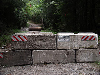 FS-63 Roadblock 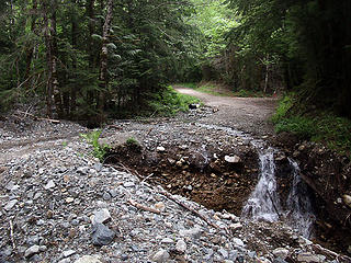 FS-63 Washout 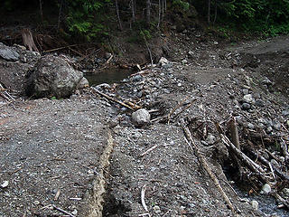 FS-2130 Washout
|
| Back to top |
|
|
greg
Member
Joined: 23 Jun 2003
Posts: 1159 | TRs | Pics
|
|
greg
Member
|
Thu Aug 16, 2007 12:42 pm |
|
|
Forest Service Reopens Westside Road to Glacier Peak Wilderness Trailhead
Darrington, WA The North Fork Sauk Road (Forest Road 49) has been reopened, with some restrictions. The road was temporarily closed in May due to impacts from winter flooding and storms.
The North Fork Sauk Road once again provides hikers and equestrians vehicle access to the North Fork Sauk Trail #649. This will provide access to the southwestern part of the Glacier Peak Wilderness on the Mt. Baker-Snoqualmie National Forest, said Peter Forbes, Darrington District Ranger.
Repairs were made to bridge approaches at Lost Creek and the North Fork Sauk River. Culverts were repaired and several new ones installed. Stock trucks and trailers can drive to the horse camp at the North Fork Sauk Trailhead. The road is closed to vehicles with trailers beyond this point. However, vehicles without trailers can continue another 2.8 miles to the Bald Eagle Trailhead.
Due to major flood damage to roads and trails in the Suiattle and White Chuck River valleys to the north, the North Fork Sauk Trail provides the only remaining stock access to the west side of the Glacier Peak Wilderness. The trail also connects to the Pacific Crest National Scenic Trail (PCNST). The Bald Eagle Trail provides access to the Henry M. Jackson Wilderness.
Forbes cautions drivers that Road 49 is a single-lane, gravel/dirt road with turnouts. Dust and roadside vegetation can affect visibility in seeing oncoming traffic, so drivers are cautioned to be alert to vehicles large and small sharing the roadway.
###
|
| Back to top |
|
|
|
|


 For ages now I've had the impression that Acrobat Reader was something left over from the dark ages of MS-DOS, I mean, it was primitive!
 I think it probably came with my camera's (the first Canon Elph) photo-editing program. Since the camera is long since out of production, I guess it's not surprising that any associated software should be out of date, too.
I still don't really like Acrobat Reader, but version 8.0 ( ! ) does at least make things legible.
I think it probably came with my camera's (the first Canon Elph) photo-editing program. Since the camera is long since out of production, I guess it's not surprising that any associated software should be out of date, too.
I still don't really like Acrobat Reader, but version 8.0 ( ! ) does at least make things legible.


