| Previous :: Next Topic |
| Author |
Message |
Newt
Short Timer


Joined: 21 Dec 2001
Posts: 3176 | TRs | Pics
Location: Down the road and around the corner |
|
Newt
Short Timer
|
 Thu Mar 27, 2003 7:05 pm |
|
|
While I was trying to create an overlay of the old EvMC RR I, was using 2 different images saved from TOPO!. One was saved @ level 4 and one @ level 5.
This is in the Monte Cristo area but a few spot checks state wide yielded the same results.
Can you see what's different? Took me awhile but the calc. varified what I thought.
Check em out.
NN 
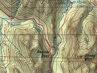 Level 4  Level 5
It's pretty safe to say that if we take all of man kinds accumulated knowledge, we still don't know everything. So, I hope you understand why I don't believe you know everything. But then again, maybe you do.
It's pretty safe to say that if we take all of man kinds accumulated knowledge, we still don't know everything. So, I hope you understand why I don't believe you know everything. But then again, maybe you do.
|
| Back to top |
  
|
|
REJ
Member
Joined: 21 Mar 2002
Posts: 100 | TRs | Pics
|
|
REJ
Member
|
Mon Mar 31, 2003 1:22 pm |
|
|
Ok NN. What I am I missing? One map is based on the 1:100,000 scale USGS map and the contour elevations are in meters. The other is from the 7 1/2-min USGS map and the contours are in feet. One map is missing the Barlow Point Trail. Anything else?
|
| Back to top |
|
|
Newt
Short Timer
Joined: 21 Dec 2001
Posts: 3176 | TRs | Pics
Location: Down the road and around the corner |
|
Newt
Short Timer
|
Mon Mar 31, 2003 1:34 pm |
|
|
You b missing nothing.
It's the feet/meters thing. I was surprised. Having never looked at the 1:100,000 paper map was unaware it was in meters.
Actually never paid that kind of attention in TOPO! either.
NN
It's pretty safe to say that if we take all of man kinds accumulated knowledge, we still don't know everything. So, I hope you understand why I don't believe you know everything. But then again, maybe you do.
It's pretty safe to say that if we take all of man kinds accumulated knowledge, we still don't know everything. So, I hope you understand why I don't believe you know everything. But then again, maybe you do.
|
| Back to top |
|
|
REJ
Member
Joined: 21 Mar 2002
Posts: 100 | TRs | Pics
|
|
REJ
Member
|
Mon Mar 31, 2003 9:02 pm |
|
|
There was a time not long ago that the US was going to convert to the metric system. The USGS 1:100,000 scale maps were developed about that time and were to the first USGS map product prepared using the metric system. I guess the metric conversion never took hold in the US. What a shame.
|
| Back to top |
|
|
Newt
Short Timer
Joined: 21 Dec 2001
Posts: 3176 | TRs | Pics
Location: Down the road and around the corner |
|
Newt
Short Timer
|
Tue Apr 01, 2003 5:25 am |
|
|
I remember. the Feds made it mandatory that all states convert, at least for orginazations like I work in. WA state was ranked one of the better in compliance. Mass amounts of money were spent converting only to convert back. I think in 2K they dropped it as no one was doing anything.
Looks like the feds fell short too or the whole lot of topos would have been metric.
NN
It's pretty safe to say that if we take all of man kinds accumulated knowledge, we still don't know everything. So, I hope you understand why I don't believe you know everything. But then again, maybe you do.
It's pretty safe to say that if we take all of man kinds accumulated knowledge, we still don't know everything. So, I hope you understand why I don't believe you know everything. But then again, maybe you do.
|
| Back to top |
|
|
Malachai Constant
Member

Joined: 13 Jan 2002
Posts: 16092 | TRs | Pics
Location: Back Again Like A Bad Penny |
The most recent Bellevue East and West as well as Seattle west and east are metric. I contributed a Issaquah Quad I had got at REI for $0.33 to scan to make their Cougar MT. map. It was the only way to get the contours to match up.
"You do not laugh when you look at the mountains, or when you look at the sea." Lafcadio Hearn
"You do not laugh when you look at the mountains, or when you look at the sea." Lafcadio Hearn
|
| Back to top |
|
|
MichaelW
Guest
|
|
MichaelW
Guest
|
Fri Apr 25, 2003 8:17 am NG TOPO! confusted
|
|
|
Some of the 1:24k quads maps in the East Coast are also done in meters as well. I can be a little confusing when you see one quad in feet and it's neighbor in meters.
|
| Back to top |

|
|
|
|


