| Previous :: Next Topic |
| Author |
Message |
JimK
Member


Joined: 07 Feb 2002
Posts: 5606 | TRs | Pics
Location: Ballard |
|
JimK
Member
|
 Tue May 28, 2002 10:54 am |
|
|
I recently posted 18 year old photos of North Bend from Si and Issaquah and the surrounding area from Tiger. I would be interested to see old photos others may have laying around. How about Monte Cristo when it was a trailhead parking lot with more buildings? The old Pilchuck lookout would be fun to compare to the new. Go back into your archives and lets see what we can come up with. Mine are at:
That was then...
|
| Back to top |
  
|
|
polarbear
Member

Joined: 16 Dec 2001
Posts: 3680 | TRs | Pics
Location: Snow Lake hide-away |
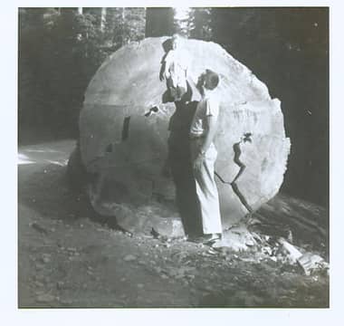
Here's a picture from a mystery road I've been trying to identify for a long time. If I can dig up some more photos I'll post them too. I believe it was in the Middle Fork or Snoq. Pass area. What a tree!
 mysteryroad
|
| Back to top |
|
|
JimK
Member
Joined: 07 Feb 2002
Posts: 5606 | TRs | Pics
Location: Ballard |
|
JimK
Member
|
Sun Jun 02, 2002 6:53 pm |
|
|
Thanks for the picture polarbear. That was exactly along the lines of what I was hoping for. 
|
| Back to top |
|
|
JimK
Member
Joined: 07 Feb 2002
Posts: 5606 | TRs | Pics
Location: Ballard |
|
JimK
Member
|
Sat Jun 08, 2002 9:29 pm |
|
|
|
| Back to top |
|
|
polarbear
Member
Joined: 16 Dec 2001
Posts: 3680 | TRs | Pics
Location: Snow Lake hide-away |
100 Hikes in Western Washington, 1966, has a great picture of the ice caves. It's hike 41. I must have been there not too long after 1981. I know the following year they had collapsed.
|
| Back to top |
|
|
JimK
Member
Joined: 07 Feb 2002
Posts: 5606 | TRs | Pics
Location: Ballard |
|
JimK
Member
|
Fri Jun 14, 2002 7:49 pm |
|
|
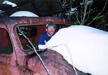
I know some of you have hiked the old road above Dirty Harry's Balcony, on the way to Webb Mountain etc... Here is a picture of the truck sitting on the side of the mountain. The difference is this photo was taken in 1986. Many of you have not seen the truck back in it's glory days.
|
| Back to top |
|
|
Logger Head
Guest

|
|
Logger Head
Guest
|
Fri Jun 14, 2002 10:02 pm |
|
|
And a recent photo of the truck:
 dirtyharrytruck
|
| Back to top |

|
|
JimK
Member
Joined: 07 Feb 2002
Posts: 5606 | TRs | Pics
Location: Ballard |
|
JimK
Member
|
Fri Jun 14, 2002 11:43 pm |
|
|
Thanks for the updated picture. 16 years of snow and sun seems to have taken it's toll. I'de love to see him drive it away...
|
| Back to top |
|
|
Sundance Kid
Hiking the Wasatch

Joined: 07 Jun 2002
Posts: 120 | TRs | Pics
Location: Orem, Utah |
|
Sundance Kid
Hiking the Wasatch
|
Sat Jun 15, 2002 8:16 am Dirty Harry?
|
|
|
Where is this cool truck? How do I get there?
Just where is it I can find beaver, bear, and other critters that are worth cash money when skint?
Just where is it I can find beaver, bear, and other critters that are worth cash money when skint?
|
| Back to top |
|
|
Logger Head
Guest
|
|
Logger Head
Guest
|
Sat Jun 15, 2002 9:06 am |
|
|
Check Karen Sykes' book "Hidden Hikes in Western Washington". A gem of a book for the roads less travelled by.
|
| Back to top |
|
|
JimK
Member
Joined: 07 Feb 2002
Posts: 5606 | TRs | Pics
Location: Ballard |
|
JimK
Member
|
Tue Jun 25, 2002 3:02 pm Old Robe Trail At High Water
|
|
|
I don't seem to be able to get you folks to dig into your old photos. Oh well, let me try one more.
Back in Novermber of 1990 it snowed heavily then rained hard. The result was our usual fall flooding. I monitored the South Fork Stilly closely. It usually ran about 800 cf/s. At the peak of this flood it was at over 26,000 cf/s. The gauge height is still monitored but the stream flow is not. I went down to the Old Robe Trail, located at the top of the hill before dropping down to Verlot. The river was running so high that at the first tunnel the water was only about 1 foot below the grade. In the summer it is about 20 feet down to the water. This photo was taken just before the entrance to the first tunnel. The noise was equal to standing on the runway at Sea-Tac.
|
| Back to top |
|
|
snag lady
Guest
|
|
snag lady
Guest
|
Tue Jun 25, 2002 7:38 pm |
|
|
One reason you may not be getting a huge response is that there are many hikers who don't have scanners or digital cameras or are in the learning stages which is a challenge for some of us old farts. As for me, I have slides going back all the way to 1979 but don't have the ability to scan them in. Wish I could figure out how to do it without spending a fortune. Don't stop downloading these great photos, though -- I certainly enjoy looking at them and I'm not alone. Frankly, I feel some disappointment when I log in and see that there aren't more responses to this topic because it is one of the more interesting subjects on the board.
|
| Back to top |
|
|
C Dog
Member
Joined: 07 Jan 2002
Posts: 140 | TRs | Pics
Location: Seattle, WA |
|
C Dog
Member
|
Wed Jun 26, 2002 12:05 am |
|
|
Yes, more photos please! I've been enjoying them, as well as the couple posted on the Otter Falls thread in Trip Repots... I'd post some, but I only started hiking 3 years ago.
|
| Back to top |
|
|
Roxann
Member
Joined: 25 Feb 2002
Posts: 29 | TRs | Pics
|
|
Roxann
Member
|
Wed Jun 26, 2002 5:57 pm |
|
|
|
| Back to top |
|
|
JimK
Member
Joined: 07 Feb 2002
Posts: 5606 | TRs | Pics
Location: Ballard |
|
JimK
Member
|
Wed Jun 26, 2002 10:35 pm |
|
|
Thanks, I think... I'm actually not quite that old. 35 years ago I was getting out of the 2nd grade. It's fun to post and look at the old pictures. I will see what else I might be able to post.
|
| Back to top |
|
|
|
|


 Please keep posting your old photos.
Also some of us are not old enough to have old photos.
Please keep posting your old photos.
Also some of us are not old enough to have old photos.  Today I went to Dungeness spit with an older group of hikers. (Who else hikes on a Wednesday) And they were talking about the ice caves up by Paradise on Mt. Ranier. I actually new what they were talking about thanks to you. They were up there about 30 to 35 years ago.