| Previous :: Next Topic |
| Author |
Message |
Karen
Member


Joined: 22 Dec 2001
Posts: 2866 | TRs | Pics
|
|
Karen
Member
|
 Sat Feb 10, 2007 11:06 pm |
|
|
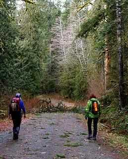
Quark, BJ and I met for this hike today along the battered forest service road but didn't make much progress. We're talking quality, not quantity -- our cameras worked harder than we did as we attempted to capture the magic of lichen, water and stone.
Things have settled down since the floods but the washouts are pretty impressive, starting at about milepost 12 -- there are three washouts in about a 2-mile stretch. We made it as far as the Huckleberry trailhead (the sign is spelled wrong!!) and could find no trace of the trail -- trees down everywhere, what a jumble. Across from the Huckleberry trailhead we scrambled down to the river and were amazed at the stones that have tumbled down, some glittering with mica or fool's gold, others sparkling like diamonds (we agreed that diamonds are not our stones of choice), all with striations and delicate tracings of geological wizardry.
It's a pretty lonesome road -- one fellow was camped at the washout and was burning garbage (not his -- left behind from other folks) but he was the only person we met all day. Admittedly, we dawdled and why not? This is the place for that because everywhere we looked we saw beauty, some of it delicate, some of it raw.
Much more could be said about this hike but if you haven't been up there, go up and see it. There's much more there than meets the eye.
We lucked out with the weather too. Nice day -- it didn't start to rain until BJ and I were on the West Seattle bridge tonight.
About 3 miles of hiking, give or take a bit -- lots of gawking and photography and tomfoolery too.
Hope Kim and BJ got better photos than I did.
Karen
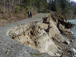 First washout, Suiattle Road 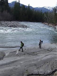 BJ and Kim, on the sandy banks of the Suiattle River, across from the Huckleberry trailhead 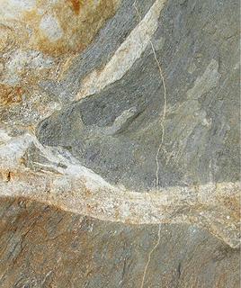 Poem in stone, geological art 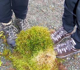 Shoe shot, sort of 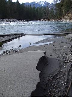 Another view of the Suiattle River 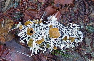 Lichen, Suiattle River Road 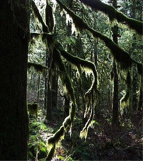 Almost like a rain forest 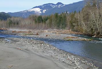 The view from the road
stay together, learn the flowers, go light - from Turtle Island, Gary Snyder
stay together, learn the flowers, go light - from Turtle Island, Gary Snyder
|
| Back to top |
  
|
|
Magellan
Brutally Handsome

Joined: 26 Jul 2006
Posts: 13116 | TRs | Pics
Location: Inexorable descent |
|
Magellan
Brutally Handsome
|
Sun Feb 11, 2007 12:05 am |
|
|
Man, that hurts. No Huck access, no Green Mt access, no Sulphur Mt access, no Suiattle river trail, image lake, etc. 
|
| Back to top |
|
|
silly_traveler
~ roaming ~

Joined: 04 Jun 2006
Posts: 1525 | TRs | Pics
Location: Bellevue |
♫ You have brains in your head. You have feet in your shoes. You can steer yourself any direction you choose. And you're the one who will decide where you'll go. Oh the places you'll go. - Dr. Seuss
|
| Back to top |
|
|
Allison
Feckless Swooner

Joined: 17 Dec 2001
Posts: 12287 | TRs | Pics
Location: putting on my Nikes before the comet comes |
|
Allison
Feckless Swooner
|
Sun Feb 11, 2007 2:57 am |
|
|
Can you tell me how far short of the Sulphur Mt TH the road ends now, and if you know, what's the FS timeline on road repairs?
www.allisonoutside.com
follow me on Twitter! @AllisonLWoods
www.allisonoutside.com
follow me on Twitter! @AllisonLWoods
|
| Back to top |
|
|
Karen
Member
Joined: 22 Dec 2001
Posts: 2866 | TRs | Pics
|
|
Karen
Member
|
Sun Feb 11, 2007 7:31 am |
|
|
ML,
My best guess -- the road ends at about 23 miles and since the closure is at 12.5 miles, you can see it is about 10.5 miles to the Sulphur Mt trailhead.
As for what the Forest Service is planning, I need to do more research before I can provide an answer.
I was kind of tired after the trip last night -- not from the walk but from the long drive and just the emotional jolt of seeing all the damage. I was somewhat prepared for that because when I went on the FS web page and looked up trails, almost every single trail was designated "Inaccessible". It was like a wake on the web if you know what I mean.
The Huckleberry Mountain trail looks like a nightmare -- complete with a new sign and still room to park but no trace of the trail. We looked for it and it was like no trail ever existed there at all.
The bridge over the Suiattle at milepost 10 (access to Circle Peak trail, FS Road No. 25) is downright scary -- not only is the far end just completely gone (it washed out on the other side) but if you look at the railings on the bridge, they are bent and crumpled as if they had been made of paper rather than metal. Like Quark said, "trees did that".
When I know more about the future of the Suiattle, I'll give you an update.
Karen
stay together, learn the flowers, go light - from Turtle Island, Gary Snyder
stay together, learn the flowers, go light - from Turtle Island, Gary Snyder
|
| Back to top |
|
|
Quark
Niece of Alvy Moore

Joined: 15 May 2003
Posts: 14152 | TRs | Pics
|
|
Quark
Niece of Alvy Moore
|
Sun Feb 11, 2007 8:29 am |
|
|
Note the trees down at Hucklberry have been cut on purpose - as I understand it, the road is going to be moved back from the slope and the area was/is in the process of being cleared. Odd we couldn't find the old trailhead, though. It was right there off the road about 3 inches, west of the parking lot where the earth widens. It was moved only 3 years ago.
The Boundary Bridge (Circle Pk) repair delay is because the bridge is within the Washington Wild and Scenic River designation, meaning the repair must not alter the original bridge - the bridge must be put in it's original condition. Rather than extend the bridge to the other side, they must bring the other side to the end of the bridge. That's a lot of dirt.  Doable, from what I've been told - but some users aren't happy with the materials necessary to do this.
This road damage, like the Beaver Lake trail damage, is not kind to the english language. There's an original road end, a 2003 road end, and the current road end - so when you ask about the road end you have to specify - and when you're talking about all trail and road ends, it's a grammatical nighmare.
It's a very beautiful river and river bottom; the alders, the pine, cottonwoods, the gravel bars, and the sound of the river itself are wild.
I do not want this road to remain closed. I read in an old Signpost magazine that they came > < this close to not repairing it in 1990 when it was washed out in the same location as the current road end (public decision, not FS).
Excellent trip, and I don't know if I've ever seen the River Road so pretty - the sun and high clouds, the clear views, the color of the river and it's shimmer.
Looking at the damage that surrounds it, and then seeing the river running low, serpentining through it's many gravel bars and islands makes you just shake your head and say to it, "Now look what you did!" It's like a child that had just had a raging fit and is now quiet. Doable, from what I've been told - but some users aren't happy with the materials necessary to do this.
This road damage, like the Beaver Lake trail damage, is not kind to the english language. There's an original road end, a 2003 road end, and the current road end - so when you ask about the road end you have to specify - and when you're talking about all trail and road ends, it's a grammatical nighmare.
It's a very beautiful river and river bottom; the alders, the pine, cottonwoods, the gravel bars, and the sound of the river itself are wild.
I do not want this road to remain closed. I read in an old Signpost magazine that they came > < this close to not repairing it in 1990 when it was washed out in the same location as the current road end (public decision, not FS).
Excellent trip, and I don't know if I've ever seen the River Road so pretty - the sun and high clouds, the clear views, the color of the river and it's shimmer.
Looking at the damage that surrounds it, and then seeing the river running low, serpentining through it's many gravel bars and islands makes you just shake your head and say to it, "Now look what you did!" It's like a child that had just had a raging fit and is now quiet.
"...Other than that, the post was more or less accurate."
Bernardo, NW Hikers' Bureau Chief of Reporting
"...Other than that, the post was more or less accurate."
Bernardo, NW Hikers' Bureau Chief of Reporting
|
| Back to top |
|
|
Solo Steve
Harry Mudd wannabe

Joined: 07 Jun 2006
Posts: 639 | TRs | Pics
Location: Federal Way |
|
Solo Steve
Harry Mudd wannabe
|
Sun Feb 11, 2007 9:43 am |
|
|
Nice TR, all -- I shoulda played hooky and joined you! That's a shame about all the damage. 
|
| Back to top |
|
|
BarbE
Member

Joined: 28 Jul 2006
Posts: 1153 | TRs | Pics
|
|
BarbE
Member
|
Sun Feb 11, 2007 10:43 am |
|
|
A few more pictures. A wonderful "wild" place with great company.
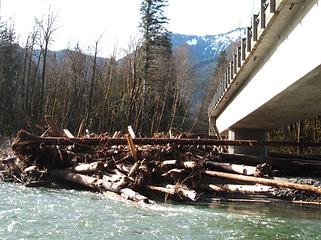 Damaged bridge 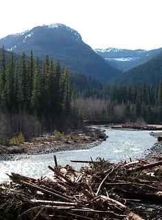 Valley view 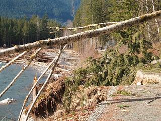 End of the road 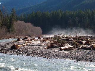 Fog on the Suiattle 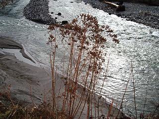 More river 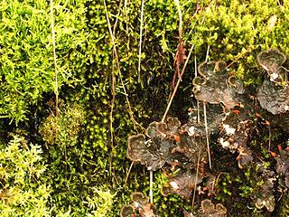 Lichen 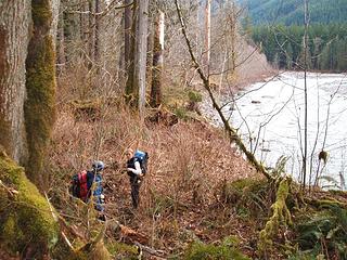 New trail around washout 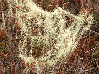 Moss everywhere
|
| Back to top |
|
|
the Zachster
Member

Joined: 17 Jan 2007
Posts: 4776 | TRs | Pics
Location: dog training |
"A wake on the web..." Well said. It's kind of strange how we are getting bits and pieces of information in the backcountry and grieving a bit at every loss. It will be a very interesting spring, summer (and years to come) as we witness the devastation and the re-birth that follows. And we we'll all be able to say "I remember when..."
"May I always be the kind of person my dog thinks I am"
"May I always be the kind of person my dog thinks I am"
|
| Back to top |
|
|
Backpacker Joe
Blind Hiker

Joined: 16 Dec 2001
Posts: 23956 | TRs | Pics
Location: Cle Elum |
Great pics and report. Thanks.
"If destruction be our lot we must ourselves be its author and finisher. As a nation of freemen we must live through all time or die by suicide."
Abraham Lincoln
"If destruction be our lot we must ourselves be its author and finisher. As a nation of freemen we must live through all time or die by suicide."
Abraham Lincoln
|
| Back to top |
|
|
Quark
Niece of Alvy Moore
Joined: 15 May 2003
Posts: 14152 | TRs | Pics
|
|
Quark
Niece of Alvy Moore
|
Sun Feb 11, 2007 8:17 pm |
|
|
Your photos "Fog on the Suiattle" and "More River" peg the trip, BJ. A beautiful, now-calm river.
"...Other than that, the post was more or less accurate."
Bernardo, NW Hikers' Bureau Chief of Reporting
"...Other than that, the post was more or less accurate."
Bernardo, NW Hikers' Bureau Chief of Reporting
|
| Back to top |
|
|
Magellan
Brutally Handsome
Joined: 26 Jul 2006
Posts: 13116 | TRs | Pics
Location: Inexorable descent |
|
Magellan
Brutally Handsome
|
Sun Feb 11, 2007 9:45 pm |
|
|
It tough about the boundary bridge. It could be said it is becoming unneccessary. FR 25 no longer goes to Gibson Falls. The only thing I see over there is 'Captain Moses Seed Orchard'. I don't know what it is, or what is does. Lime Creek, FR 25, all those roads have been deteriorating for years.
With the new Circle Peak/Crystal Lake trail access will be from the old Crystal Lake/Meadow Mt TH. They have rebuilt Circle Peak over Skar Pass and connected it with the Crystal Lake 'trail'. I know they very much want to rebuild an ancient trail connecting to FR 2700, as opposed to the crappy, alder-infested road walk that exists now. The Meadow/Crystal TH is much closer to FR 23, Whitechuck river road. They have an unbelievable amount of work to do on that road and the Whitechuck trail.
I always had a blast going over Rattrap Pass. One time I was out with my girl, driving our pickemup truck over Rattrap. I look up, and here comes my mom and her friend going the other way. Neither one of us had any idea the other was in the area.
|
| Back to top |
|
|
Jason Hummel
Member

Joined: 31 Aug 2006
Posts: 1209 | TRs | Pics
Location: Tacoma Washington |
Thanks for the report! I like to hear about the suiattle area. It is where I spent a lot of time kayaking, and I've enjoyed many hikes in the area. Its good to get some up-to-date info.
|
| Back to top |
|
|
Quark
Niece of Alvy Moore
Joined: 15 May 2003
Posts: 14152 | TRs | Pics
|
|
Quark
Niece of Alvy Moore
|
Mon Feb 12, 2007 1:37 pm |
|
|
Pics. God, what a beautiful place!
 Hikers walk the Suiattle River Road with white Alder trees ahead of them 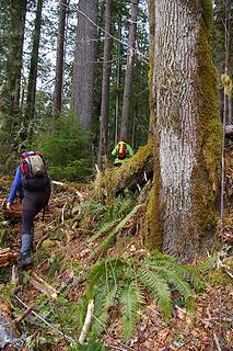 Karen & Barbara off trail with no compass or GPS 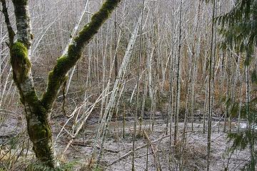 doghair of alders in river slough 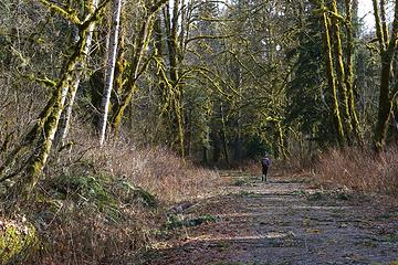 Walking the road 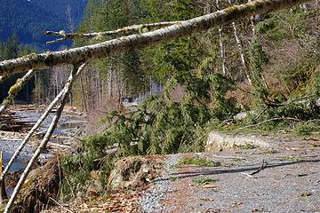 Kickin' it when it's down - blowdown on top of washout 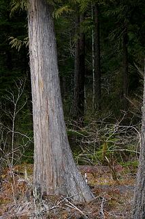 Cedar trunk 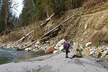 Karen & Barbara on the beach at Hucklberry, roadbed above 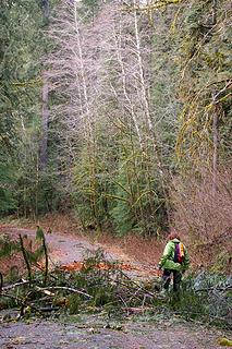 Barbara and alders 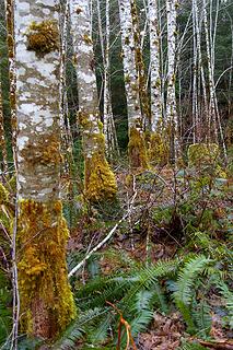 alder trunks in a row 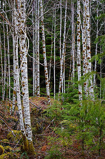 Alders on sideroad off the Suiattle
"...Other than that, the post was more or less accurate."
Bernardo, NW Hikers' Bureau Chief of Reporting
"...Other than that, the post was more or less accurate."
Bernardo, NW Hikers' Bureau Chief of Reporting
|
| Back to top |
|
|
|
|
You cannot post new topics in this forum
You cannot reply to topics in this forum
You cannot edit your posts in this forum
You cannot delete your posts in this forum
You cannot vote in polls in this forum
|
Disclosure: As an Amazon Associate NWHikers.net earns from qualifying purchases when you use our link(s). |


 That hurts
  Thanks for the TR Karen


