| Previous :: Next Topic |
| Author |
Message |
Badger
Member


Joined: 01 Aug 2006
Posts: 1172 | TRs | Pics
Location: Alki Beach, Washington |
|
Badger
Member
|
 Sun Mar 04, 2007 8:34 pm |
|
|
|
| Back to top |
  
|
|
kleet
meat tornado

Joined: 06 Feb 2002
Posts: 5303 | TRs | Pics
Location: O no they dih ent |
|
kleet
meat tornado
|
Tue Nov 06, 2007 10:39 am |
|
|
The Library of Congress has an exhibition entitled Maps In Our Lives ongoing. I was there in June but didn't know about the exhibit, dammit! They do have quite a few map exhibits online, including maps George Washington prepared of his estate in the 1760s.

A fuxk, why do I not give one?
A fuxk, why do I not give one?
|
| Back to top |
|
|
Gsnorgathon
Mile-per-hour club

Joined: 20 Feb 2007
Posts: 129 | TRs | Pics
|
|
Gsnorgathon
Mile-per-hour club
|
Tue Nov 06, 2007 5:49 pm |
|
|
While we're at it...
Here's the Monte Cristo page from a 1960s Metsker's map book. They've got a few other interesting tids on their site, including a 1934 map book of Snohomish county.
|
| Back to top |
|
|
Jake
Member
Joined: 13 Jun 2004
Posts: 257 | TRs | Pics
Location: monroe, Wa. |
|
Jake
Member
|
Tue Nov 06, 2007 6:57 pm |
|
|
Ive never been a big fan of Metzkers maps. Too many boo boos on them. For instance; the Monte Cristo map linked above shows the placer claims that should be on the Sauk River are a good distance above even the road. I know some of the folks that own these patented claims and they are not on Addison Peak as indicated on the map. They are on the river.
That is only an example.
Ill stick with USGS and Green Trails maps.
|
| Back to top |
|
|
Gsnorgathon
Mile-per-hour club
Joined: 20 Feb 2007
Posts: 129 | TRs | Pics
|
|
Gsnorgathon
Mile-per-hour club
|
Tue Nov 06, 2007 9:24 pm |
|
|
That's good to know about the Metsker maps. FWIW, they've got Kroll, too. (That's a link to the 1934 Snohomish county map. They've got others, but strangely, no maps that cover all of King county.)
|
| Back to top |
|
|
Jake
Member
Joined: 13 Jun 2004
Posts: 257 | TRs | Pics
Location: monroe, Wa. |
|
Jake
Member
|
Tue Nov 06, 2007 10:15 pm |
|
|
Yes, I've found Kroll maps to be good maps. Most of the old Anderson's maps are good too. The Anderson's are now owned and printed by Kroll. Most of those are from 1896 and 1897.
|
| Back to top |
|
|
geobob
Member

Joined: 29 Sep 2007
Posts: 183 | TRs | Pics
Location: seattle |
|
geobob
Member
|
Sat Nov 10, 2007 10:23 pm |
|
|
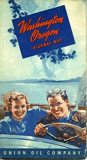
Thought this might be of interest. It's a road map of Washington from 1939. I have scanned and cropped the portion that shows a proposed road over Cascade Pass. I have read of this proposed road before, but thought that seeing the real deal might be interesting to you PNW history buffs.
 MapCover 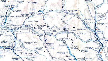 Pass Road
I think there's an easier way on the far side
I think there's an easier way on the far side
|
| Back to top |
|
|
Jake
Member
Joined: 13 Jun 2004
Posts: 257 | TRs | Pics
Location: monroe, Wa. |
|
Jake
Member
|
Sat Nov 10, 2007 10:31 pm |
|
|
Thanks geobob, I like those old maps. That one is interesting in how they screwed Ruby Creek up. I'd like to see more maps of that vintage. They're fun to compare with todays maps.
|
| Back to top |
|
|
peltoms
Member

Joined: 13 Jul 2006
Posts: 1760 | TRs | Pics
Location: Worcester MA |
|
peltoms
Member
|
Sun Nov 11, 2007 5:47 am |
|
|
Nice old map geobob. The Twisp River has an interesting ability to cross the divide.
|
| Back to top |
|
|
-lol-
Member
Joined: 17 Dec 2001
Posts: 767 | TRs | Pics
|
|
-lol-
Member
|
Sun Nov 11, 2007 4:29 pm |
|
|
|
| Back to top |
|
|
Gsnorgathon
Mile-per-hour club
Joined: 20 Feb 2007
Posts: 129 | TRs | Pics
|
|
Gsnorgathon
Mile-per-hour club
|
Sun Nov 11, 2007 5:43 pm |
|
|
Uh-oh. There goes more than a couple of hours, right there...
Thanks? 
|
| Back to top |
|
|
MLHSN
What goes here?????

Joined: 09 Sep 2007
Posts: 1069 | TRs | Pics
Location: Wenatchee |
|
MLHSN
What goes here?????
|
Sun Nov 11, 2007 10:35 pm |
|
|
|
| Back to top |
|
|
Bergschlawiner
Member

Joined: 20 Apr 2006
Posts: 177 | TRs | Pics
Location: North Bend WA |
When arrived here in 1967 at Ft Lewis, rapidly accumulated a stock of every 1:50.000 scale AMS (Army Map Series) topo maps of the state which I used for years hiking, and still do sometimes. Used to highlight trails with red pencils and they showed lots of old trails that are now abandoned. Great maps and the price was right if you know what I mean!
|
| Back to top |
|
|
More Cowbell
Warrior Princess

Joined: 01 Jul 2006
Posts: 5657 | TRs | Pics
Location: Alive on Earth |
Old (1968-73) WA USGS maps at Craigslist
If you want to forget all your other troubles, wear too tight shoes. - Unknown
If you want to forget all your other troubles, wear too tight shoes. - Unknown
|
| Back to top |
|
|
|
|


