| Previous :: Next Topic |
| Author |
Message |
Sore Feet
Member


Joined: 16 Dec 2001
Posts: 6307 | TRs | Pics
Location: Out There, Somewhere |
Stomp and I seem to be developing this habbit of heading to semi-obscure locales, Cherry Lake for example. Lake Isabel seemed to be a natural progression of this trend. So, we headed out today, hoping that we wouldn't have to deal with off-roaders enjoying the extended weekend.
Upon arriving at the Reiter Pit, we were less than thrilled to see a varitable circus of dirtbikers and their RV's parked along a torn up section of the pit area. Signs pointed towards "trial" along Reiter Road, obviously they were talking about some sort of race.
Hoping they'd stay away from us, we turned up the road to the "trailhead", and as we passed under the powerlines, they seemed to die off, though there were routes marked all through the area (though we didn't run into anybody actually biking until we were driving out).
Reaching the trailhead is definitely the easiest part of this near-debachle. Follow the pretty well groomed road from Reiter Road, under the powerlines, then turn left at the junction (follow the major road, not the one under the powerlines). Drive as far as you can from this point. Stomp's '80-something Escort didn't make it all the way due to a few unreasonably large mudholes. If you can make it to the fork in the road, park at this point.
Ahead, about 500 feet, down either fork lies May Creek. This time of year, it's not advised that it be forded, but later in the summer it ought to be easy. The easiest way to reach the lake doesn't require fording anyway. At the point where the road forks, there is a maze of dirtbike paths in the woods to the right (north) of the road. What you want to do is go more or less straight into the woods, don't follow the road. You should eventually come to the hillside, where the trail proceeds straight up, extremely steeply in places, for several hundred vertical feet. Not having seen proper directions before, we made the mistake of following a faint path right next to the creek for as far as we could, then started bushwhacking and sidehilling uphill until we eventually hit the easily recognizable trail.
Once you've reached the top, the trail levels out, the maze of paths disappears and the route becomes a lot more obvious (if you have any trouble at all, just head uphill, following the sound of the creek). There are a series of biker-bridges (where they jump 10 feet off of the end sort of thing) that you should be seeing on the way up too.
Once at the top of the hill, the trail is pretty level for about 3/4 of a mile, where it starts to veer to the east (staying on this route will lead to the mine). Keep a watch for a well-worn tread leading back downhill, to the left, and follow it downhill to the first bridge across May Creek, just shy of a mile from the "trailhead". There are a pretty series of waterfalls above and below the bridge to enjoy while you rest.
After crossing the bridge, follow the trail to the right (upstream) for a short distance, to where it switch-backs almost 180 degrees. Keep a watch for flagging, because the route to the Lake turns bck almost 180 degrees, and keeps following the creek, almost immediately after it turns away from the creek. We got disoriented at this point, but were fortunate enough to run into a group of people heading to the lake (who we followed the whole way) who knew the proper trail. From here, the trail gets steeper, as it climbs up to the old road frequented (apparently) by the off-roaders.
The trail hits the road a little over 1/2 way to the Lake. Once you reach the road, head right, back towards May Creek, and follow the road to the second bridge, which will bring you back to the east side of the creek. Oddly, a small stream coming down the road from the other side of the bridge seems to actually be crossing the bridge over May Creek. Probably one of the few places in the world where a natural stream crosses another natural stream.
Anyway, from here, the so-called "road" becomes a messy streambed, with hardly a square inch of ground not covered by big light gray boulders...which doesn't make traveling easy. Another 1/3 of a mile or so up this road-turned-streambed and you'll come to a nice open area on the left, with the sound of a small waterfall (in the spring) ahead of you on the small stream that occupies the road. The road makes a sharp left and heads into the woods, still paralleling May Creek.
By now, you ought be able to hear the falls coming down from the western outlet of Lake Isabel. Unfortunately, it can't be seen without some serious bushwhacking (as far as I know). Keep heading up the road to a switchback, and start looking for a flagged path heading to the left, still contouring May Creek. We spotted 4 flags marking the trail. Be aware that there were at least two marked trails, you do NOT want to take the first one.
Once you've found the trail, the rocky "roadbed" is left behind for nice, level, open forest travel (save for farily profuse windfalls). Another 1/3 of a mile or so brings you to the bottom of the spectacular waterfall at the lake's eastern outlet. Stomp was kind enough to take an elevation reading, and I was able to measure the falls at 334 feet tall, give or take no more than 15 feet, plus another 100 feet or so of talus cascades. There are several places to view the falls, the best being just a few feet off of the trail, so don't bother crashing around in the brush in this area.
From here, the trail goes straight up the hill, using roots and rocks as footholds. As long as you take it slow, it's not that hard. Once at the top of the climb, the lake is just a minute away. Total elevation gain is 2300 feet in 2.4 miles.
The lake is just gorgeous. Mountains rise 1500+ feet around the lake, when there isn't any wind, the reflection is outstanding (best I've seen to date). The logjam at the outlet provides nice picnicing grounds, and there's even a dumpster next to a streamgauge on May Creek immediately below the outlet (the streamgauge was particularly weird at that location, but the dumpster just blew my mind). The group of people we were following said something about a float-plane wreck on the island between the two outlet streams, but we couldn't find it (though we didn't look all that hard). No sign of the boat that was reported to be tied up somewhere on the shoreline, didn't see any floatplanes on the lake, though one buzzed us as we were climbing up. There's a little gorge on May Creek between the logjam and the top of the falls that was particularly cool looking though.
I really liked this hike, awesome waterfall aside, I'll definitely be heading back eventually. Not for someone who doesn't have good routefinding skills, and maps are essential (gps is even better). I've attatched a map with the key points labeled. Pictures coming hopefully sooner than later.
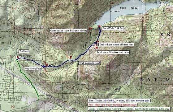 isabel trailmap
|
| Back to top |
  
|
|
salish
Member

Joined: 17 Dec 2001
Posts: 2322 | TRs | Pics
Location: Seattle |
|
salish
Member
|
 Tue May 27, 2003 5:59 am |
|
|
Sore Feet : that's the best trip report for Lake Isabel I've ever seen. Thank you for taking the time and effort to go into such detail. I was first at Isabel as an invading boy scout back in 1965, but I made it there again about six years ago as my re-introduction to backpacking and since "I knew the way" I didn't bother with maps. Well, the trail had changed since 1965 (back then you could drive a normal rig up that boulder-strewn road almost at that level campground/plateau area). To make a long story short, on the trip six years ago we crossed over May Creek down where you park your car and headed off in an northwesterly fashion in order to hit the road. We guestimate we turned the hike into roughly five miles of goofy logging roads and trails west of the creek before we made it to that level plateau just before the steep part to the lake.
You haven't mentioned garbage, refuse, and the obligatory tattered blue tarps laying around, so I'm hoping people have cleaned up part of the camp area at the south outlet. It was a gross mess when I was last there. There are a few Beavers (airplanes) in the lake, from what I've been told. We ran into a crew in a boat that was trying to salvage a Beaver from the lake when we were there. Actually, they were just using sonar to find the craft at that point. That was the night we camped near the outlet and were attacked by hundreds (maybe thousands) of mice about midnight. As if by signal they came out all at once. I was awakened by a mouse running across my face and through my hair, and more scurrying over my sleeping bag. My buddy and I had a cheap little one person tent and set it up really fast and got inside and ended up spooning all night (our wives still tease us about that). In the morning we found the mice had ravished our packs and shredded everything that could be shredded, and scattered it all over the area. It was like a cloud of locust had flown in. Pretty weird.
ANyway, great report. Now that I have really good directions I may head back up there this year.
Salish
My short-term memory is not as sharp as it used to be.
Also, my short-term memory's not as sharp as it used to be.
My short-term memory is not as sharp as it used to be.
Also, my short-term memory's not as sharp as it used to be.
|
| Back to top |
|
|
Backpacker Joe
Blind Hiker

Joined: 16 Dec 2001
Posts: 23956 | TRs | Pics
Location: Cle Elum |
Nice report. i've been up there on feet, and in 4x4's. The last time was after a Lake Buccaneer amphibian crashed taking 4 with it. They had national guard helicopters taking out the aircraft.
Big fish in that lake.  TB
TB
"If destruction be our lot we must ourselves be its author and finisher. As a nation of freemen we must live through all time or die by suicide."
Abraham Lincoln
"If destruction be our lot we must ourselves be its author and finisher. As a nation of freemen we must live through all time or die by suicide."
Abraham Lincoln
|
| Back to top |
|
|
Sore Feet
Member
Joined: 16 Dec 2001
Posts: 6307 | TRs | Pics
Location: Out There, Somewhere |
Salish - There wasn't too much trash around the outlet. There was one tarp in one place, a little ways away from the outlet, and there was a small pile of rusted junk on the island between the two outlets, but it looked like most of the garbage in the area was properly deposited in the big green dumpster next to the stream gauge. Didn't come across any evidence of mice either.  BPJ - If by big fish, you mean little fish, then yes ('course I only saw one).
|
| Back to top |
|
|
Backpacker Joe
Blind Hiker
Joined: 16 Dec 2001
Posts: 23956 | TRs | Pics
Location: Cle Elum |
No sir, LARGE mackinaw be's in that tub O water!
TB
"If destruction be our lot we must ourselves be its author and finisher. As a nation of freemen we must live through all time or die by suicide."
Abraham Lincoln
"If destruction be our lot we must ourselves be its author and finisher. As a nation of freemen we must live through all time or die by suicide."
Abraham Lincoln
|
| Back to top |
|
|
Sore Feet
Member
Joined: 16 Dec 2001
Posts: 6307 | TRs | Pics
Location: Out There, Somewhere |
| Backpacker Joe wrote: | | No sir, LARGE mackinaw be's in that tub O water! |
Best not be letting Weyrick know 'bout that. 
|
| Back to top |
|
|
Backpacker Joe
Blind Hiker
Joined: 16 Dec 2001
Posts: 23956 | TRs | Pics
Location: Cle Elum |
"If destruction be our lot we must ourselves be its author and finisher. As a nation of freemen we must live through all time or die by suicide."
Abraham Lincoln
|
| Back to top |
|
|
salish
Member
Joined: 17 Dec 2001
Posts: 2322 | TRs | Pics
Location: Seattle |
|
salish
Member
|
Tue May 27, 2003 12:18 pm |
|
|
Nice going, BPJ...................................
My short-term memory is not as sharp as it used to be.
Also, my short-term memory's not as sharp as it used to be.
My short-term memory is not as sharp as it used to be.
Also, my short-term memory's not as sharp as it used to be.
|
| Back to top |
|
|
Backpacker Joe
Blind Hiker
Joined: 16 Dec 2001
Posts: 23956 | TRs | Pics
Location: Cle Elum |
Oh God, that damn lake ISNT even in a protected area! Everybody knows that it's got mackinaws!
TB
"If destruction be our lot we must ourselves be its author and finisher. As a nation of freemen we must live through all time or die by suicide."
Abraham Lincoln
"If destruction be our lot we must ourselves be its author and finisher. As a nation of freemen we must live through all time or die by suicide."
Abraham Lincoln
|
| Back to top |
|
|
salish
Member
Joined: 17 Dec 2001
Posts: 2322 | TRs | Pics
Location: Seattle |
|
salish
Member
|
Tue May 27, 2003 4:12 pm |
|
|
Well, if they didn't know, they do now......
(Take it easy BPJ, I'm just razzing you).
My short-term memory is not as sharp as it used to be.
Also, my short-term memory's not as sharp as it used to be.
My short-term memory is not as sharp as it used to be.
Also, my short-term memory's not as sharp as it used to be.
|
| Back to top |
|
|
Backpacker Joe
Blind Hiker
Joined: 16 Dec 2001
Posts: 23956 | TRs | Pics
Location: Cle Elum |
I know, I know, I know!
Damn F I S H!
TB
"If destruction be our lot we must ourselves be its author and finisher. As a nation of freemen we must live through all time or die by suicide."
Abraham Lincoln
"If destruction be our lot we must ourselves be its author and finisher. As a nation of freemen we must live through all time or die by suicide."
Abraham Lincoln
|
| Back to top |
|
|
|
|
You cannot post new topics in this forum
You cannot reply to topics in this forum
You cannot edit your posts in this forum
You cannot delete your posts in this forum
You cannot vote in polls in this forum
|
Disclosure: As an Amazon Associate NWHikers.net earns from qualifying purchases when you use our link(s). |


